Study on Communal Land Registration in Lao PDR - MekongInfo
←
→
Page content transcription
If your browser does not render page correctly, please read the page content below
Study on

           Communal Land Registration
                 in Lao PDR
           Land Policy Study No. 6 under LLTP II

                               Katrin Seidel
                             Khamla Phanvilay
                             Bounlath Vorachit
                                 Lau Mua
                          Somthong Boupphachan
                            Robert B. Oberndorf

Sponsored by: Lao-German Land Policy Development Project
           (German Contribution to the Land Titling Project II in Lao PDR)

                                                    February 2007
This study is part of a series of Land Policy Studies conducted in preparation of a
coherent and comprehensive “National Land Policy Statement for Lao PDR”.
The following studies have already been published in this series:
No. 1: Study on Land Allocation to Individual Households in Rural Areas
of Lao PDR; December 2004
Authors: Bouakham Soulivanh, Anothai Chantalasy, Phounsavat
Suphida, Florian Lintzmeyer, Florian Rock
No. 2: Study on Land Markets in Urban and Rural Areas of Lao PDR;
March 2005
Authors: Bouakham Soulivanh, Anothai Chantalasy, Phounsavat
Suphida, Florian Lintzmeyer, Florian Rock
No. 3: Study on Land Tax and Fees Policy in Lao PDR; February 2006
Authors: Simon Keith, Pheuiphanh Ngaosrivathana, Bouakham
Soulivanh, Onsy Phimsomphou, Chanh Denuthai
No. 4: Study on State Land Leases and Concessions in Lao PDR;
June 2006
Authors: Gunda Schumann, Pheuiphanh Ngaosrivathana, Bouakham
Soulivanh, Somboun Kenpraseuth, Khamdeng Onmanivong,
Khamthanh Vongphansipraseuth, Chithasone Bounkhong
No. 5: Study on Urban Land markets in Lao PDR; September 2006
Authors: Babette Wehrmann, Bouakham Soulivanh, Khamdeng
Onmanivong
_______________________________________________________________
iiAcknowledgement
The study team would like to thank all the organizations and individuals that have contributed
to the success of this study. The results of our work have greatly benefited from our
discussions with government officials of the Department of Land, the National Land
Management Agency, the Ministry of Justice and the Ethnic Department of the Lao Front for
National Construction. Particular thanks go to GTZ staff in Luang Namtha province and Dak
Lak province (Vietnam) for technical and logistical support. We are also particularly grateful
to Holger Grages and Gerry Duckitt of the German Agro Action Integrated Poverty Reduction
Project for sharing their time, knowledge, experience, and homes during our stay in
Phongsaly province.
Last but not least, we would like to thank the people in all study villages that have received
us and our questions with enormous patience and generous hospitality.
iiiTable of Contents
ACKNOWLEDGEMENT..................................................................................................................................III
TABLE OF CONTENTS.................................................................................................................................... IV
LIST OF TABLES, MAPS AND FIGURES.......................................................................................................V
LIST OF ACRONYMS ...................................................................................................................................... VI
EXECUTIVE SUMMARY............................................................................................................................... VII
I. INTRODUCTION ............................................................................................................................................. 1
1.1 BACKGROUND ............................................................................................................................................... 1
1.2 OBJECTIVES................................................................................................................................................... 1
1.3 STUDY TEAM................................................................................................................................................. 2
1.4 METHODOLOGY ............................................................................................................................................ 3
1.5 INTRODUCTION TO THE STUDY VILLAGES ..................................................................................................... 5
1.6 LIMITATIONS OF THE STUDY ......................................................................................................................... 6
1.7 DEFINITIONS AND TERMINOLOGY ................................................................................................................. 7
II. RESULTS FROM THE FIELD WORK........................................................................................................ 9
2.1 COMMUNAL TENURE SYSTEMS ..................................................................................................................... 9
2.2 MANAGEMENT SYSTEMS OF COMMUNAL LANDS ........................................................................................ 13
2.3 CHARACTERISTICS OF COMMUNITIES AND USER GROUPS ........................................................................... 17
2.4 CONFLICTS AND CONFLICT RESOLUTION .................................................................................................... 18
2.5 ROLE AND IMPORTANCE OF COMMUNAL LANDS ......................................................................................... 19
2.6 TRENDS AND IMPLICATIONS FOR COMMUNAL LAND MANAGEMENT .......................................................... 21
2.7 PERCEPTION ON COMMUNAL LAND REGISTRATION .................................................................................... 23
III. TOWARDS COMMUNAL LAND REGISTRATION IN THE LAO PDR ............................................ 25
3.1 OBJECTIVES FOR COMMUNAL LAND REGISTRATION ................................................................................... 25
3.2 RISKS INVOLVED IN THE REGISTRATION OF COMMUNAL LANDS ................................................................. 26
3.3 OPTIONS FOR COMMUNAL LAND REGISTRATION ........................................................................................ 27
IV. EXPERIENCES FROM CAMBODIA AND VIETNAM ......................................................................... 30
4.1 HISTORY AND BACKGROUND ...................................................................................................................... 30
4.2 LEGISLATIVE FRAMEWORK ......................................................................................................................... 31
4.3 STATE OF IMPLEMENTATION ....................................................................................................................... 33
4.4 LESSONS LEARNED...................................................................................................................................... 35
V. LEGAL AND POLICY IMPLICATIONS OF COMMUNAL LAND REGISTRATION ...................... 37
5.1 EXPLANATION OF REGISTRATION AND TITLING .......................................................................................... 37
5.2 RECOGNIZING COMMUNITIES AND USER GROUPS FOR COMMUNAL TITLING .............................................. 38
5.3 TYPES OF LAND FOR REGISTRATION AND TITLING ...................................................................................... 39
5.4 TYPES OF RIGHTS GRANTED THROUGH REGISTRATION AND TITLING .......................................................... 40
5. 5 LAND AND FOREST LAND CATEGORIES/CLASSIFICATIONS ......................................................................... 41
5.6 AMOUNT OF LAND TO BE REGISTERED AND TITLED .................................................................................... 42
5.7 RECOGNITION OF CUSTOMARY USE ............................................................................................................ 42
5.8 LAND DISPUTE CONFLICT RESOLUTION PROCEDURES ................................................................................ 43
5.9 CAN COMMUNAL LAND TITLE BE RECOGNIZED IN THE CURRENT FRAMEWORK? ........................................ 44
5.10 OPTIONS FOR SUPPORTING COMMUNAL LAND TITLE ................................................................................ 45
VI. SUMMARY OF RECOMMENDATIONS AND NEXT STEPS .............................................................. 48
6.1 NATURE AND CONTENT OF COMMUNAL TITLE ........................................................................................... 48
6.2 LEGAL AND POLICY DEVELOPMENT WITH REGARDS TO COMMUNAL LAND TITLING .................................. 50
6.3 IMPLEMENTATION OF COMMUNAL LAND TITLING ...................................................................................... 51
6.4 CLOSING THE KNOWLEDGE GAP: FURTHER RESEARCH AND STUDIES......................................................... 52
LITERATURE REFERENCE........................................................................................................................... 53
APPENDIX I: TERMS OF REFERENCE ....................................................................................................... 56
ivAPPENDIX II: LIST OF INTERVIEWS IN VIENTIANE ............................................................................ 60
APPENDIX III: TIME SCHEDULE................................................................................................................. 61
APPENDIX IV: VILLAGE CHECKLIST ....................................................................................................... 62
APPENDIX V: VILLAGE PROFILES............................................................................................................. 69
BAN NONGBUA, SING DISTRICT, LUANG NAMTHA PROVINCE .......................................................................... 69
BAN MOM, SING DISTRICT, LUANG NAMTHA PROVINCE .................................................................................. 70
BAN LAOKHAO, SING DISTRICT, LUANG NAMTHA PROVINCE .......................................................................... 71
BAN HOUYHOY, SING DISTRICT, LUANG NAMTHA PROVINCE .......................................................................... 72
BAN HOUAYVANGKAO, MAI DISTRICT, PHONGSALY PROVINCE....................................................................... 73
BAN PHIA, MAI DISTRICT, PHONGSALY PROVINCE ........................................................................................... 74
BAN OMPOULOU, MAI DISTRICT, PHONGSALY PROVINCE ................................................................................ 75
BAN SOPHOUNE, MAI DISTRICT, PHONGSALY PROVINCE ................................................................................. 76
BAN SAEN IN, MAI DISTRICT, PHONGSALY PROVINCE...................................................................................... 77
BAN NONG SAM CHE, PEK DISTRICT, XIENGKHUANG PROVINCE ..................................................................... 78
BAN PHONE KHAM, PEK DISTRICT, XIENGKHUANG PROVINCE......................................................................... 79
BAN KHAI, PEK DISTRICT, XIENGKHUANG PROVINCE ...................................................................................... 80
BAN OR AN, PEK DISTRICT, XIENGKHUANG PROVINCE .................................................................................... 81
BAN TAT HAI, PHINE DISTRICT, SAVANNAKHET PROVINCE ............................................................................. 82
BAN TANG ALAI, PHINE DISTRICT, SAVANNAKHET PROVINCE ......................................................................... 83
BAN NATHONG, PHINE DISTRICT, SAVANNAKHET PROVINCE ........................................................................... 84
BAN NONYANG, PHINE DISTRICT, SAVANNAKHET PROVINCE .......................................................................... 85
BAN THONGNAMEE, PAKKADING DISTRICT, BOLIKHAMXAY PROVINCE........................................................... 86
BAN NAMDUA, PAKKADING DISTRICT, BOLIKHAMXAY PROVINCE................................................................... 87
BAN HOUYLERK, THAPHABATH DISTRICT, BOLIKHAMXAY PROVINCE ............................................................. 88
BAN SOMSAARD, THAPHABATH DISTRICT, BOLIKHAMXAY PROVINCE ............................................................. 89
APPENDIX VI: ROLES AND DUTIES OF RELEVANT AUTHORITIES................................................. 90
APPENDIX VII: LIST OF RULES AND REGULATIONS REVIEWED.................................................... 92
List of Tables, Maps and Figures
TABLE 1: DETAILED SCHEDULE FOR FIELD WORK IN INDIVIDUAL VILLAGE………………………3
TABLE 2: SUMMARY OF INFORMATION ON STUDY VILLAGES………………………………………...5
TABLE 3: ETHNIC COMPOSITION OF STUDY VILLAGES…………………………………………………6
TABLE 4: TYPES OF COMMON OR COMMUNAL LANDS………………………………………………...12
MAP 1: MAP OF FIELD SITES AND MAIN ETHNIC GROUPS……………………………………………....4
FIGURE 1: DRIVING FORCES OF CHANGE IN THE MANAGEMENT OF COMMUNAL LANDS……...21
vList of Acronyms
FLA Forest Land Allocation (Vietnam)
DAFEO District Agriculture, Forestry and Extension Office
DARD Department of Agriculture and Rural Development
DONRE Department of Natural Resources and Environment
GTZ German Technical Cooperation
LL Land Law
LUP/LA Land Use Planning/Land Allocation
NAFRI National Forestry and Agriculture Research Institute
NGO Non-governmental organization
NLMA National Land Management Agency
NTFP Non-timber forest product
RDMA Rural Development in Mountainous Areas
viExecutive Summary
Rethinking of priorities for land titling projects in the Lao PDR is needed to stop the current
trend towards conversion of communal lands to other uses mainly agricultural and tree
plantations. Instead of focusing exclusively on the registration of individual land holdings it is
important to understand and recognize customary tenure systems that support both
communal and individual use of land and natural resources.
Field visits to over twenty villages in five different provinces of the Lao PDR have shown that
across all ethnic groups, communities use and manage communal lands. Types of lands
often found to be under communal management include upland areas, grazing lands and
village use and sacred forests. Communities and use groups have devised local rules for
provision, management and appropriation of communal resources.
Land held in common by a community or user group plays a crucial role for the social,
economic and cultural well-being of rural communities. The recognition of communal land
rights in statutory law is therefore well in line with national goals of poverty reduction and
sustainable use of land and natural resources.
On the other hand, formalizing customary tenure systems also involves risks that need to be
carefully addressed in appropriate policies and legislation. The language in existing law and
regulation does not clearly support the concept of registering communal land property rights.
Two options should be considered: 1) extending the definition of the term “organization”
found in current legislation to include communities and user groups or 2) make necessary
amendments to the Land and Forestry Laws. An open multi-stakeholder policy debate
informed by results from pilot activities testing the registration of communal lands should
form the basis for the decision.
Valuable lessons for the process of recognizing communal land rights can also be drawn
from two neighbouring countries. The governments of the Kingdom of Cambodia and the
Socialist Republic of Vietnam have adopted provisions of long-term statutory land use rights
of community groups based on customary tenure systems.
A comprehensive policy and legal framework is needed to support the successful
implementation of communal land titling in the Lao PDR. But registration of communal lands
is not an end in itself. It legally empowers communities to protect and manage their
communal resource base. Follow up support systems including monitoring, enforcement of
management rules, and incentives need to be in place to ensure equitable and sustainable
use of communal lands after registration and titling.
viiI. Introduction
1.1 Background
For many decades, communal systems of managing land relations were perceived as
outdated and inefficient. The rights assigned to individuals within communal land tenure
systems were thought to be insufficient to provide necessary tenure security as precondition
to intensify agricultural production. Most land reform efforts therefore centred on the formal
recognition of exclusive individual land use rights as seemingly the most efficient property
arrangement.
Communal land tenure systems, however, have existed and evolved over a long period of
time. They are well adapted systems based on customary laws that connect the present
generation with past and future generations, and the human with the spiritual world. In the
Lao People’s Democratic Republic (Lao PDR), communal property rights regimes represent
an integral part of the cultural, social, political and economic framework of the majority of
communities across all ethnic groups.
In recent years, there has been an apparent change in the attitude towards customary tenure
systems (Fitzpatrick 2005). This new orientation is in part due to a shift in the international
policy debate from a primary focus on economic development towards the goal of
sustainable use and management of land resources. It is increasingly recognized that in
order to achieve the latter, rural people need both secure individual rights to their farm lands
and secure communal rights to resources upon which whole villages depend.
With regards to land right registration, it has been realized that building on existing
customary tenure systems is easier and more appropriate than trying to re-invent the wheel
(World Bank 2003). Premature attempts at establishing formalized structures for land under
customary tenure have led to unintended distributive effects, high costs of enforcement,
wide-spread disputes and decrease in natural resources (Fitzpatrick 2005, Native Title
Report 2003). In general, there is a growing appreciation of the role communities and
communal tenure systems play in the sustainable use and management, as well as
protection of land and natural resources.
The government of the Lao PDR has recognized customary land use rights for example
under the Forestry Law and in several forestry-related Decrees, as well as in Ministerial
Decree 997 of the Ministry of Finance, which acknowledges individual land use rights based
on customary ways. Under the current legal framework, however, there are no clear
provisions and procedures for the registration of communal rights on land. The amended
Land Law (2003) and the implementation guidelines to the Law (PM Decree 101) only
distinguish areas falling under individual land use right and state land units. In the process of
land registration, communally held resources are therefore either privatized or registered as
state land units. This potentially puts rural communities at risk of loosing control over their
customary use areas, such as grazing areas, use forest areas, NTFP collection areas etc. to
investors applying for state land leases and concessions.
1.2 Objectives
The main purpose of the study is to explore questions related to the formal registration of
communal lands. Overall objectives include:
To identify and categorize land use areas currently under communal tenure
To assess the need to register and title communal rights to land
1 To recommend appropriate legal mechanisms and options for the registration of
communal lands
More specific objectives are listed in the terms of reference for the study in Appendix 1. Due
to the short timeframe and the complexity of the topic, this paper can only provide initial
information and a checklist of issues in order to a) initiate and support a policy discussion on
the registration of communal lands in the Lao PDR, b) recommend next steps towards
communal land registration and c) point towards knowledge gaps and topics for further study.
1.3 Study Team
The study team consisted of six members:
Somthong Boupphachanh is a lecturer at the Faculty of Social Sciences, Department of
History at the National University of Laos. She has a Bachelor’s degree in History and
Geography from the Pedagogical University of Laos, and a Master degree in Rural
Development Management from Khon Kaen University in Thailand.
Bounlath Vorachit has a Bachelors Degree in Business Law from the National University of
Laos. He is the head of the land registration unit at the Department of Land, previously under
the Ministry of Finance, and will continue his important work under the new National Land
Management Agency. Bounlath has significantly contributed to the development of
implementation manuals on land registration in the Lao PDR. He has trained the Systematic
Adjudication Teams on investigation methods and continues to teach the process of land
registration to staff of provincial land offices and in upper levels of the Polytechnic School.
Lau Mua has been a lecturer at the Faculty of Forestry at the National University of Laos for
nearly twenty three years. He holds a Master degree in Forest Economics from Kasetsart
University, Thailand. He was born in a Hmong community in Xiengkhuang province.
Khamla Phanvilay is currently finalizing his PhD at the University of Hawaii at Manoa, with a
fellowship from the East West Center. His research focuses on land use and livelihoods
changes in two Northern provinces of Laos. Khamla holds a Master degree in Natural
Resource Management and Planning from the Asian Institute of Technology, Thailand. He
also teaches watershed management and land use planning at the Faculty of Forestry,
National University of Laos.
Katrin Seidel holds a Master degree in International Agricultural Science from the Humboldt
University Berlin, Germany. She has worked on land rights issues in Southeast Asia since
1999. Katrin lives and works in Cambodia, where she has supported the implementation of
communal land rights registration for more than three years. After this assignment, she will
return to Cambodia as programme coordinator for the Heinrich-Boell Foundation.
Robert B. Oberndorf is an international legal consultant with nearly fifteen years of law
practice experience. He graduated from Case Western Reserve University School of Law
(United States) in 1993 with a Juris Doctorate degree, and has been working in the
Southeast Asian region on issues related to natural resources, environmental protection and
governance reform since 2001. He is currently based in Bangkok, Thailand where he works
for the Regional Community Forestry Training Center for Asia and Pacific (RECOFTC).
21.4 Methodology
In addition to literature review and key informant interviews in Vientiane (see Appendix 2 for
list of persons interviewed), the study team conducted almost six weeks of field survey in five
provinces in the north, centre and south of the Lao PDR. In order to get a first hand
impression on the experiences with forest land allocation to local communities, the team also
visited a pilot village in Dak Lak Province, Vietnam and held discussions with the responsible
staff at district and province levels (see Appendix 3 for time schedule).
The results from the fieldwork were first presented to a small peer group and finally
discussed in a half-day workshop with representatives from the Lao Government and
international organizations. Comments and suggestions from workshop participants have
been incorporated into this report.
1.4.1 Theoretical Framework
Property rights theory, common-pool resources theory and the institutional analysis and
development framework (Ostrom 1990, Oakerson 1992) formed the theoretical foundation for
the study. With regards to the institutional analysis and development framework, the study
team particularly looked at the context that determines action-outcome linkages and
therefore influences decisions of individual actors and groups regarding the use and
management of land and natural resources. The contextual framework is set by the physical
and material nature of the resource, attributes of the community and the rules-in-use.
Although the time spent in each village was too short to conduct a comprehensive
institutional analysis, the study team collected information on a) the village context and
attributes of the community or user groups; b) the physical aspects of the village territory or
resource system, including boundaries; c) resource appropriation and provision rules; d)
governance and decision making, and e) conflict resolution mechanisms (see Appendix 4
for village checklist).
1.4.2 Fieldwork Methods
Information was gathered, using qualitative and participatory methods from the tool-box of
Rapid Rural Appraisal and Participatory Rural Appraisal including semi-structured interviews
(SSI), resource mapping and transect walks 1 . Table 1 shows the detailed time schedule for
the fieldwork in each village.
Day 1 Day 2
Morning Resource mapping
Transect walk
Final interview with Naiban
Afternoon Arrival in study village Travel to next village
Key informant interview with Naiban
(village head)
Evening SSI with village committee and
elder group
Table 1: Detailed schedule for field work in individual village
1.4.3 Selection of Field Sites
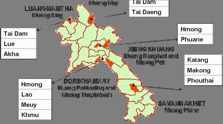
For the field study, the team selected 21 villages in 7 districts and 5 provinces (see Map 1)
based on the following criteria:
Ethnic composition: Villages were selected to represent a wide range of ethnic
groups of the Lao PDR. In addition to the majority of study villages that comprised
1
These and other fieldwork methods are described in Schoonmaker-Freudenberger (1994).
3only one main ethnic group, six villages were selected that are home to a number of
different ethnic groups.
Village history: With regards to the history of the village, the study team selected
traditional communities with a long common history and villages that were only
recently established. This allowed for a comparison of traditional with more modern
practices of communal land and natural resources management. Several study
villages were also targeted for relocation or village consolidation.
Experience with land and forest allocation: Partly conflicting with the criterion of
accessibility (see below), the study team identified eight villages for the field survey
where land and forest allocation has not yet taken place. In all other villages land use
planning (LUP) and land allocation (LA) has been conducted. In two villages of Luang
Namtha province the team was able to study the results of the improved LUP/LA
process.
Accessibility: Due to the tight time schedule, all study villages had to be accessible
within a maximum of 2-3 hours drive or walk. This prerequisite made it difficult to
explore a wide range of experiences with government programs on land and natural
resource use and allocation. In all selected province, the majority of the better
accessible villages had already undergone land and forest allocation.
Local partners: The team relied on local partners, including government officials and
staff of international organizations, for a first introduction to the selected villages,
logistical support and translation.
Topography and livelihood systems: Study villages were selected to reflect a wide
range of topographic situations and agro-ecological production zones, including rain-
fed wet-rice cultivation in lowland and plateau areas and shifting cultivation on rolling
hills and on lower and mid-level mountain slopes.
Map 1: Map of field sites and main ethnic groups 2
2
Since no standard exists for the transliteration of place names from Lao to English language, different spelling
versions can be found throughout literature (e.g. Xiengkhouang or Xiengkhuang). The spelling of names of
41.5 Introduction to the Study Villages
Table 2 summarizes main information on the 21 study villages as a first overview. In
Appendix 4, all villages are moreover described in short village profiles. The village profiles
are an attempt to capture the complexity of land and forest related issues that were identified
in the study villages.
Province District Village # of Ethnic Year Territory Year of
HH compo established in ha LUP/LA
sition or age
Luang Namtha Sing Nongbua 255 mixed 1991 55 none
Mom 133 Lue > 100 years 1,004 2005
Laokhao 56 Akha 1991 505 2000
Huayhoy 28 Akha 1998 1,210 2005
Phongsaly May Houayvangkao 44 Thai Dam > 400 years - none
Phia 42 Khammu > 100 years 1,500 (2000)*
Ompoulou 73 Sungkor > 50 years 2,320 (1998)*
Sophoune 77 mixed > 200 years - 2002
Saen In 24 Khammu 1965 1,115 2000
Nonghed Nong Sam Che 40 Hmong > 150 years 572 none
Xiengkhuang Phone Kham 38 Phuane 170 years 144 2006
Pek
Khai 64 Phuane > 200 years 500 none
Or An 39 Hmong 1961 - 1999
Tat Hai 91 Katang 1988 2634 1999
Savannakhet
Phine Tang Alai 63 Katang 100 years ca. 3,000 none
Nathong 167 Makong > 200 years 8,200 1998
Nonyang 152 mixed 1931 - none
Pakkading Thongnamee 515 Hmong 2003 6,000 2003
Bolikhamxay Namdua 300 mixed 1966 - 2003
Thaphabath Houylerk 112 mixed 1986 1,300 2000
Somsaard 80 mixed 1957 758 1999
Table 2: Summary of information on study villages
* Year of land use planning and boundary demarcation (no land and forest allocation)
In accordance with the first criterion of field site selection, villages representing a wide range
of ethnic groups were chosen for the field survey. The study team visited a total of 17 ethnic
groups, representing ethnic groups belonging to all four main language groups in the Lao
PDR (see Table 3). The village profiles in Appendix 4 also provide a short background to
the individual ethnic group.
provinces, districts and ethnic groups in this study is in accordance with the 2005 Lao population census. With
regards to village names, the most common spelling is used.
5Language Thai-Kadai Austro- Miao-Yao Sino-Tibetan
Group Asiatic
Study
Villages
Nongbua Thai Dam*, Lao Phounoy, Lolo,
Akha, (Lao Pane)**
Mom Tai Lue
Laokhao Akha
Huayhoy Akha
Houayvangkao Thai Dam
Phia Khammu
Ompoulou (Laosoung Khoe)
Sophoune Thai Dam, Thai Khammu
Daeng
Saen In Khammu
Nong Sam Che Hmong
Phone Kham Phuane
Khai Phuane
Or An Hmong
Tat Hai Katang
Tang Alai Katang
Nathong Makong
Nonyang Phouthay Katang
Thongnamee Thai Dam, Lao Khammu Hmong
Namdua Lao, (Thai Pao), Khammu
(Meuy), Phuane,
Houylerk Lao, Phuane Khammu
Somsaard (Meuy), Lao
Table 3: Ethnic composition of study villages
* Majority ethnic groups in the village in bold letters
** Ethnic groups in brackets are not among the officially recognized 46 ethnic groups.
1.6 Limitations of the Study
Although the study considers the situation of a variety of ethnic groups, the results presented
in this paper are based on a limited number of cases from literature review and the field
survey. They can therefore not be regarded as representative for the over 11,000 villages in
the Lao PDR.
6Topics discussed during the fieldwork included questions related to cultural norms, customs
and traditions with regards to the use and management of land and natural resources. Due to
the limited timeframe, however, these questions could only be superficially explored and in-
depth anthropological studies are needed to better understand the complex tenure systems
of the various ethnic groups in the country.
In addition to the comparatively short timeframe that affects scope and depth of the study
results, other limitations include biases inherent in the design of the study and selected field
methods. This includes seasonal biases, biases in the selection of study villages, language
and conceptual difficulties, and preconceptions of the members of the study team.
Finally, the fluid nature of customary rules represents additional difficulties. Since decision-
making authorities enjoy a certain degree of discretion in seeking feasible compromises,
actual decisions and outcomes of conflict situations may vary and even significantly divert
from formulated rules (Holleman 1986).
1.7 Definitions and Terminology
Customary tenure is the mode of holding rights in land that exists through customs and
tradition. Customary tenure systems have evolved over centuries and continue to exist in
many countries with a large rural population where access, control and use of land are
determined through customary law (Foerster and Apel 2004). Customary tenure
arrangements are generally characterized by overarching ritual and cosmological relations
with traditional lands, community rights of control over the disposal of land, membership
based criteria for land access, community-based restrictions on dealings with outsiders and
principles of reversion of unused land to community control (Fitzpatrick 2005). Due to the
strong emphasis on the control and management responsibilities of the community,
customary tenure arrangements are also often called communal tenure systems.
Communal land under communal tenure systems is “the land property of a well-defined and
demarcated group that uses the land communally according to known and mutually accepted
rules. Non-members of the group are often excluded from use or have lesser rights” (GTZ
1998). It is important to note that although the tenure to land is group-based, land use is in
the hand of individual families. Communal tenure systems therefore represent a balance
between collective and individual rights. Rights to use, rights to exclude, and limited transfer
rights (e.g. inheritance) to land and natural resources can be temporarily allocated to
individuals in accordance with customary law. However, power of management, full transfer
rights and rights of alienation are vested in the community as a whole. The term in Lao
language best describing the concept of communal rights to land is ‘sit suam luam’.
Collective property or ‘sit luam mou’ is recognized in the Constitution of the Lao PDR
(2003) and defined in the Property Law (1990) as “property belonging to a collective” that can
be “co-operatives and other collective organizations” (Article 2). Although collective and
communal property are similar concepts, the understanding of ‘collectives’ (‘sahakoum’) and
‘collective organizations’ (‘ankar khom luam mou’) relates more to the model of an
unincorporated association with rights vested in individuals by virtue of their membership. It
does not capture the notion of the ‘community’ as an entity that transcends the members as
individuals as it is the case in communal land tenure systems. The question whether the
definition of ‘collective property’ as a type of property recognised in the Property Law can be
extended to include ‘communal property’ is essentially a political one (see discussion below).
In the paper, however, we will differ between ‘communal rights’ (‘sit suam luam’) and
‘collective rights’ (‘sit luam mou’) to land as two different concepts.
7Communal land registration and titling as used in this paper can be understood as the
formal recognition of communal rights to land in statutory law. In case of the Lao PDR, the
study team perceives the recognition of communal land rights in statutory law as the most
feasible approach (see discussion in Chapter 3). Other options to legalize communal land
claims include a) their formal recognition in full accordance with customary law, which may
entail separate legislation and administration, and b) the allocation of entire geographical
areas for an ethnically defined group (which can be found for example in Canada, the United
States and several South-American countries). It should be noted, however, that the option
to recognize communal claims to land under statutory law will lead to regulations that are not
in full compliance with customary practices. Risks and implications of the inevitable gap
between customary and statutory law are discussed below.
8II. Results from the Field Work
2.1 Communal Tenure Systems
The research team set out to study customary tenure systems among 17 ethnic groups in 21
villages located in five different provinces of the Lao PDR. But what does one look for when
studying tenure?
2.1.1 Definition and Concepts
Tenure systems are related to property. However, property is not an object but rather the
social relationships that on individual or a group of individuals may possess or exercise
(Bromley 1992). Land tenure can thus be described as social relationships or institutions that
govern access to and the use of land and natural resource (Maxwell and Wiebe 1999).
Depending on how rights are attributed, scholars have classified property rights schemes into
four categories including state property, private property, common property, and open access
or the absence of any property rights arrangement.
Since the publication of Hardin’s essay “Tragedy of the Commons” in the Science journal in
1968, there have been a lot of misconceptions about the nature of common property
regimes. Hardin claims that the degradation of natural resources is inevitable whenever
many individuals use a scarce resource in common. His assumption that productive use can
only be realised by centralization or privatization of natural resources still influences the
general discussion on property reform. Based on the empirical evidence of well-functioning
communal management systems, a more differentiated view on collective tenure
arrangements and resource management has emerged in recent years. It is widely
acknowledged that common or communal property regimes ensure equitable and
sustainable use of resources as long as the tenure system is formally recognised and
effectively enforced (Foerster and Apel 2004).
Even in a private property rights situation not all rights to land or natural resources are vested
in the individual or group. The State often reserves the right to restrict private rights in the
use and management of the resource and certain right attributes always remain in the public
domain (Sjaastad and Bromley 1996). It is therefore more appropriate to think of property
rights as a bundle of rights over resources that include rights of access, withdrawal,
management, exclusion, and alienation (Schlager and Ostrom 1992).
2.1.2 Characteristics of Communal Tenure Systems
In the field, we observed similar characteristics of customary tenure systems across all
communities and ethnic groups. The traditional systems of resource use and management
assure individual access to resources over which the entire user group or community holds
collective claim. All communal tenure systems thus have a collective and an individual
dimension.
Communities have established claims to particular land areas by different means. Often they
have named their village after characteristic features of the landscapes they have used for
their subsistence to emphasize their claims to resources. Many village names reveal the
founder or founding clan of the settlement or a prominent natural feature. Among animist
communities, the relationship to a location or place has an important spiritual dimension (see
Box 1) and community members pay respect to village and other nature spirits.
9Box 1: The Spirit Forest in Ban Nathong
The spirit or sacred forest forms identity and spiritual foundation of the community in Ban
Nathong, a Makong village in Savannakhet province. In accordance with local customs and
traditions, the first settlers in Ban Nathong area could not establish an independent village without
their own village spirit. As the population of the settlement gradually increased, people in Ban
Nathong performed a ceremony and invited the village spirit of Ban Dongsavan, an already
established village, to come and live in the spirit forest of Ban Nathong. Since then, Ban Nathong
has been considered an independent village and continued respect for the spirit forest ensures
that villagers enjoy the protection of their tutelary village spirit.
Although resource mapping in traditional villages without LUP/LA demonstrated that
boundaries were often not clearly defined, members of neighbouring communities respected
and recognized the use zones and resource claims of their neighbours. Many traditional
communities perceive land differently from the established Western idea of geographical
points on a grid (Sjaastad and Bromley 1996). Land encompasses a collection of natural
resources that are used by the community often independently of the coincidence of their
location. Growing scarcity of land and natural resources has led to an increasing awareness
of the importance of boundaries in the majority of the study villages. This has further been
accelerated by the delineation of village boundaries in the LUP/LA process. However,
boundary demarcation has often caused conflicts between neighbouring communities and
has sometimes even compromised the resource base of the community itself (ADB 2001).
Within the collectively claimed territory of the community, households establish individual
rights by productively using the resources upon and within the land (see Box 2). This right is
tied to membership and non-members are either excluded or enjoy lesser rights. Extent and
duration of rights depend on the respective rules and customs of the community and are
traditionally determined by the labour that is invested by the household and nowadays
increasingly by the scarcity of the resource.
However, tenure is not only a bundle of socially accepted rights to benefit streams from land
and natural resources. Very often all of these rights only extend to certain attributes of the
resource. This is well illustrated by the example that in many study villages after the rice
harvest, paddy fields become the communal grazing area for all livestock in the village.
Individual households only hold rights to the fruits of the labour invested in the paddy fields
but this right does not exclude the collective use of the area for grazing. Another example
illustrating the complex relationship of individual and collective rights is the pond in Ban Nong
Sam Che.
Box 2: The Pond in Ban Nong Sam Che
Ban Nong Sam Che is named after a natural pond in the shape of a triangle that serves as water
source for the village. Every villager in Nong Sam Che has access to the water of the pond.
Recently, a young man in the village had the idea to release fingerlings in the pond to raise fish.
All fishes in the pond now belong to the young man and his family. But the pond and the water are
still the communal property of all villagers in Nong Sam Che.
The use and management of resources is governed by rules of conduct or local customary
law to which all members of the group subscribe. Members are equals in their rights to use
the resource. But not all members are equal regarding the quantity of resource use.
Traditionally, resource units are allocated depending on the needs and capacity of the
individual household. In study villages where households have started to actively participate
10in the market economy, we have observed that land allocation has become increasingly
uneven 3 .
Decision making power with regards to land and natural resources is usually vested in the
village chief (Naiban) and the village committee or specialised committees for land use and
allocation, where existent. The actual enforcement of local rules and regulations is often left
with the elder group as guardians of harmony and solidarity in the community. In some study
villages, the traditional leader ‘chao kok chao lao’, clan leaders, shamans, fortune tellers and
other keepers of customary local law still play an important role in decision making and in
mediating conflicts over land and natural resources. Decisions on local rules and the
resolution of conflicts are usually made and announced in public village meetings and every
villager is expected to respect the local rules and report any infringements within the
boundaries of the community.
Across all study villages, communal tenure systems represent a balance between the
collective rights and responsibilities of the community and individual rights and duties of
community members. This balance is shifted depending on incentives for more permanent
claims to land and natural resources. However, the study team observed that in most villages
this shift has been realised within the customary tenure arrangement without abandoning the
communal aspect of the system.
In the following sections, we will more specifically identify and categorize types of land under
communal tenure and describe different communal management systems observed in the
field. With a view to titling options of communal land, we will furthermore look at the
characteristics of communities and user groups, and explore how decisions are made and
conflicts over land and natural resources are solved.
2.1.3 Types of Land under Communal Tenure
Transect walks and resource mapping showed that villages that have fully or partly
completed the LUP/LA process generally have a good understanding of their village
boundaries and distinguish between a larger number of different land use types within their
territory. They commonly use the categories introduced during the land use zoning 4 step.
Communities without land use zoning and planning usually differ between residential areas,
permanently cultivated fields, upland fields, grazing areas, natural and domestic fish ponds
and two categories of forests, production and protection forests.
In all but one of the study villages, households cultivate agricultural land in neighbouring
villages or outsiders have land holdings inside the village boundaries of the study village.
This mainly concerns land for paddy cultivation (57 percent of the study villages) but also
upland fields (70 percent of the study villages that practice shifting cultivation). Forests for
collection of NTFPs and grazing areas are often shared across village boundaries.
All of the 21 study villages have land areas that are commonly shared among all members of
the community. People in all study villages 5 perceive their forests areas to be the communal
property of the entire community. This was particularly strongly emphasized for spirit or
sacred and cemetery forests. In addition to sacred forests and trees, villagers also protect
and worship sacred water bodies, such as natural ponds or river pools.
3
One such example is Ban Mom in Luang Namtha province. Families that first started to plant rubber now have
land holdings of over five hectares. Less affluent households have sometimes less than two.
4
This includes residential and agricultural use areas, paddy and plantation land, as well as conservation,
protection, regeneration and production (or village use) forests.
5
This excludes Ban Nongbua, one of the study villages in Luang Namtha province. The small village land of 55
ha does not encompass any forest area. However, villagers in Nongbua expressed their need for a common
forest area and have started negotiations with neighbouring communities over a small piece of forest adjacent to
their village territory.
11All villages have land within their residential areas that serves spiritual or public purposes,
such as land for temples, markets, hospitals, wells, school buildings and sports grounds.
Households in about half of the study villages are cultivating rice in upland fields. In all of
these communities, upland areas are perceived as communal and households only establish
temporary exclusion and transfer rights at certain points during the rice cultivation cycle. A
number of villages also reserve areas for agricultural production where the land is not yet
allocated to individual use.
For grazing areas we found the probably widest range of management arrangements. In
some villages, no specific areas are designated for grazing and livestock from people inside
and outside the community freely roam forests and fallowed rice fields. In other villages,
households or clans establish full management, exclusion and alienation rights to fenced
areas of grassland.
In the following table we have summarized all types of common or communal land found in at
least one of the study villages. It is important to note that some of the mentioned land use
types might be considered communal in some villages but are permanently allocated to
individual households in others. For a better understanding of the rights situation applying to
the identified types of land under current statutory law, we have listed them according to the
land categories of the 2003 Land Law.
Agricultural land Forest land Cultural land Construction land
Public facilities Residential places
Grazing areas Village use forest Temple areas Schools Reserve land
Upland fields Rehabilitation Cemeteries Markets for house
Reserve land forest Sacred forest* Recreation construction
for agriculture Protection forest areas
Fishponds Conservation Health
forest stations
Tree plantations Wells
Sacred forest*
Table 4: Types of common or communal lands
* Sacred forest is listed under both forest and cultural land since the nature of sacred forests fits both
categories.
The presented list in Table 4 is by no means exhaustive. During the initial presentation of our
results, the study team was informed about wetland areas that are communally managed by
communities in some of the lowland provinces. Further research could therefore certainly
add other types of communal lands.
When asked about the tenure situation in their village, people had different understandings of
what is meant by communal lands. Communal lands were variously interpreted as all those
lands within the village territory that are a) not individually claimed, b) preserved and
protected for the common good of the community, c) available to all households with equal
rights and duties, and/or d) used to facilitate communal public services.
This variety of interpretations is partly due to the fact that in accordance with the definition
presented at the beginning of this chapter, in all long-established villages the entire village
area could be considered as communal land. The community as a whole has laid claim to a
particular territory and members have established individual rights in accordance with local
rules and customs. The rights to some land use areas, e.g. paddy fields, housing plots,
agricultural plantations and partly grassland, have been firmly established and passed on
from generation to generation. These land areas are no longer perceived as part of the
12communal domain. During our field survey, people therefore often identified communal lands
by a negative definition. They are all those lands that are not individually claimed.
As the individualization of land tenure expands to areas that have formerly been regarded as
common, certain areas remain communal in the sense that all members of the community
continue to enjoy equal access rights and local rules for appropriation and provision are
devised. For our discussion on options for communal land titling, we will focus on these types
of communal lands for three reasons. First, existing local rules and management practices
are needed to support and sustain communal land title. Second, these areas are particularly
vulnerable in context of the rapid changes many rural communities in the Lao PDR are
currently experiencing. And third, these lands are of particular importance to the livelihoods
of the majority of community members.
In the next section we will therefore look at management systems of upland fields, forests
and grasslands found in the study villages 6 .
2.2 Management Systems of Communal Lands
Traditional systems regulating access, withdrawal, management, exclusion and alienation of
natural resources upon and within lands held in common by a village community have
evolved over centuries. In many of the study villages, property relations among communities
constitute ‘taboo relations’ with certain forms of taking and appropriating or giving and
alienating considered to be forbidden. These taboos as part of the local customary law
governing the use of land and natural resources are guarded by elders and traditional
leaders in the community. Elders and other custodians of local law do not represent an
independent authority but use their experience, knowledge and understanding to seek
feasible compromises through mediation and negotiation. Local rules and customs are thus
flexible and can be adjusted to fit changing circumstances.
With the advent of LUP/LA, local land and natural resource management systems have
taken a more formalized character in rural villages in the Lao PDR. Rules and regulations
applying to the different types of land within the demarcated village territory are stipulated in
village land use management agreements. However, the formalized regulations have not
fully replaced the traditional systems and we have mostly found hybrid forms of land and
resource management rules in study villages that have undergone land use planning and
allocation.
2.2.1 Upland Areas
Although government policy to eradicate shifting cultivation has overall led to a significant
decrease in the area used for traditional upland agriculture and swidden farming, more than
half of the study villages continue to depend on rotational upland cultivation for their
livelihoods.
All shifting cultivation systems found in the study villages follow a rotational scheme and the
allocation of individual cultivation plots to households is regulated by local rules. Outsiders
are usually excluded. In some of the study villages, however, outsiders are accepted but
7
have to pay fees for the use of upland areas . Households in Ban Ompoulou, a Laosoung
6
It should be noted, however, that it could certainly be beneficial for a village community to have recognized
communal use rights to construction land within the village boundaries. This is demonstrated by the example of
Ban Nongbua, a mixed ethnic village in Luang Namtha province, where villagers have swapped smaller
communal areas within the settlement for a large plot to build a school.
7
In Ban Pia, a Khammu village in Phongsaly province, outsiders pay 30,000 kip maintenance fee per swidden
plot to the village community.
13Khoe village in Phongsaly province, regularly rent swidden fields from neighbouring villages
(see Box 4).
In the visited Khammu communities in Phongsaly province, all households of the village
rotate annually between large blocks of land for upland rice cultivation (see Box 3). In Ban
Houyhoy, an Akha village in Luang Namtha province, families discuss the location of their
individual swidden fields within a larger designated area at the beginning of the cultivation
cycle. Location and size is finally approved by the Naiban and the village committee based
on available Labour in the family. In the two Hmong communities in Xiengkhuang province,
households have adopted an integrated upland rice and livestock grazing system. Grazing
areas, if suitable, are regularly used to plant rice and maize. After one year of cultivation, the
area is again used for cattle grazing (see Box 6).
Box 3: Shifting cultivation practice of Ban Pia
All farming households in Ban Pia, a Khammu village in Phongsaly province, cultivate upland rice
in the same large area or block of land. There are several such blocks in different stages of fallow
within the village territory. Every year at the beginning of the cultivation cycle a new fallowed block
is selected for all households to do upland farming. Households remember the location of their
previously cultivated plots since they still hold exclusion rights to NTFPs found on their swidden
areas. They also enjoy first rights to their former plot when the area is allocated to individual
families. According to the local custom, however, households will not cultivate the same plot for
more than three times. Size and location of individual plots are discussed in a series of village
meetings and depend on the actual need and capacity of the households. Villagers in Ban Pia
follow the common Khammu tradition of omen taking. If after clearing a small part of the new field
something that is taboo occurs in a dream or any other bad omen is met, the piece of land is
abandoned and the household will look for a new place. This custom and other traditions related
to the cultivation practices of the Khammu are well described in Simana (undated).
A common feature across all study villages is the communal and individual dimension of
shifting cultivation systems. All villagers including newcomers and young families have equal
access rights to the shifting cultivation area of the community. As soon as individual plots are
allocated to the farming household, the household has full withdrawal, management and
exclusion rights. Households do not enjoy rights of transfer and alienation. The swidden plots
can not be sold and even the failure to cultivate the field can lead to the allocation of a
smaller sized plot in the following year.
Traditionally, it depends on the respective custom of the community or ethnic group for how
long households maintain exclusion rights to their swidden areas. In the studied Khammu
villages in Phongsaly province, households maintain exclusion rights to their fallowed
swidden plots until the beginning of the next cultivation cycle (see also Box 3). In Ban
Sophoune, a mixed Thai Dam, Thai Daeng and Khammu village, households had no
individual rights to the fallows. The same holds true for the visited Akha villages in Luang
Namtha province. In many of the study villages, fallowed swidden areas are used for the
cultivation of perennial cash crops and tree plantations and with the investment of labour
households uphold their rights to the plots.
We also observed that the scarcity of the resource plays an increasingly important role in the
articulation of individual rights to upland areas. In Ban Ompoulou, a Sungkor village,
households have fixed plots within the upland rotation zones and accommodation of the
needs of new families has become increasingly difficult (see box 4).
14You can also read