Tenement Review and Exploration Strategy- EL007330 Daylesford - Client: Red Rock Australasia - Power Metal Resources
←
→
Page content transcription
If your browser does not render page correctly, please read the page content below
Tenement Review and
Exploration Strategy- EL007330
          Daylesford

Client: Red Rock Australasia

Prepared by:   Dave Sharp
Reviewed by: Kirsty Sheerin
Revision:      0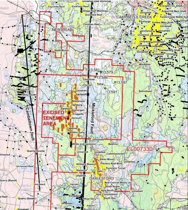
OreTeck Mining Solutions
                                                                                                ABN: 84 625 670 948
                                                                                           Level 3, 257 Collins Street
                                                                                               Melbourne, VIC, 3000
                                                                                             Tel: +61 (03) 8375 9662
                                                                                              inquiries@oreteck.com
                                                                                                    www.oreteck.com

1   Daylesford- EL007330
                                                                      Mapping
        Tenement                                                                                     Current
                                Local ID                 Size (km2)   Sheet         Municipality
        ID                                                                                           Status
                                                                      (1:100,000)

        EL007330                Daylesford               191          Castlemaine   Hepburn          Application

      EL007330 is located around the town of Daylesford in Central Victoria. A narrow portion of
      the tenement extends north towards Newstead, adjacent to EL007282 (Yandoit). This
      narrow section has not been assessed as part of this report, instead the focus has been on
      the advanced staged projects in the Daylesford area (Figure 1).

                                        Figure 1. EL007330 Location and geology.

      J000095 Red Rock Tenement Review- EL007330 Daylesford_Rev0                                            Page 1 of 16
OreTeck Mining Solutions
                                                                                           ABN: 84 625 670 948
                                                                                      Level 3, 257 Collins Street
                                                                                          Melbourne, VIC, 3000
                                                                                        Tel: +61 (03) 8375 9662
                                                                                         inquiries@oreteck.com
                                                                                               www.oreteck.com
2     Regional Geology
              EL007330 is located in the Bendigo Structural Zone of the Tasman Fold Belt and covers
              the north-trending Muckleford Fault. The basement lithology comprises of interbedded
              slates, siltstones and sandstones turbiditic sequences of the Ordovician Castlemaine
              Group that have undergone east-west compression during the Benambran Orogeny.
              Limb thrusts propagating from bedding parallel layer slip planes formed as fold lock up
              approached. The folds form part of larger scale anticlinoria which form broad, gently
              plunging dome and basin structures. The Daylesford Goldfield is located at the
              culmination of such a dome on the Daylesford Anticlinorium. Major west-dipping reverse
              faults are interpreted as listric faults. The regional north-northwest trending Muckleford
              Fault passes 3 km west of Daylesford and truncates the Daylesford Anticlinorium west
              of its hinge (Gough, 2013). Widespread orogenic gold mineralisation associated with
              faulting occurred during the late stages of deformation (Arden, 1997).
2.1    Local Geology
            MacDonald, 2006, undertook a thorough review of the local geology in the Daylesford
            area. The following information is a summary of this work.

              Underground mapping in several mines by the GSV has shown an alternating sequence
              of shale and sandstone horizons. In practice these may sometimes represent shale
              horizons up to 2 metres wide, sandstones that may be massive channel deposits up to
              10 metres thick, or alternatively they may represent upward fining sand dominated
              turbidite units mapped individually or as groups of units with similar characteristics. In
              practice, the distinction between stratigraphic units in the field is extremely difficult.

              Folds in the area are upright with axial planes dipping steeply to the east, with
              wavelengths varying from over 500 metres to less than 50 in some places. The fold
              pattern appears to be far less regular than that observed in the mineralised corridors of
              the Bendigo or Castlemaine goldfields. Although faulting may in part explain this
              irregularity, it appears likely that significant variation in wavelength does exist, as shown
              on several traverses that have been mapped in detail by the GSV.

              Larger amplitude folds appear more likely to host significant mineralisation, with the Ajax
              and Cornish lines associated with two of the broadest fold limbs in the area. While the
              general opinion appears to be that folds in the area generally plunge to the north,
              particularly in the northern end of the field, preliminary examination of the available mine
              plans, combined with the relationship between the faulting and bedding, strongly
              suggests that the overall plunge of the Ajax anticline is to the south in the Ajax South
              (14°S) and Christensen’s Ajax (17°S and 3°S, although here one northerly plunge was
              also noted) mines. North plunges were noted in the Ajax Consolidated Mine on the south
              end of the field.

              On the Cornish line the only recorded plunge direction was in the North Cornish Mine
              where an 8°S plunge was noted on the 834’ level. Most plunges measured are less than
              10° and would generally be classified as horizontal folds.

        J000095 Red Rock Tenement Review- EL007330 Daylesford_Rev0                                     Page 2 of 16
OreTeck Mining Solutions
ABN: 84 625 670 948
Level 3, 257 Collins Street
Melbourne, VIC, 3000
Tel: +61 (03) 8375 9662
inquiries@oreteck.com
www.oreteck.com
It was noted that the workings rarely cut west of the anticline, tending to explore well to
the east on most occasions. The relationship between bedding-cleavage lineation did
not appear to be recognised, so that the only recorded plunges are where the fold hinge
could be observed.
The development of thrust faults during fold development, and particularly after fold ‘lock
up’ may be recognised in most Central Victorian goldfields, for example Ballarat and
Fosterville. These structures provide conduits for fluid flow and mineralisation, and as
such are the key features controlling the development of quartz reef related
mineralisation in the region. A summary of the styles of mineralisation developed in this
setting is contained in Figure 2, based on examples in the Castlemaine Goldfield, these
styles have been recognised in other ‘slate belt’ goldfields in the region with minor
variations.
Figure 2. Examples of fold related vein systems in Central Victoria. Daylesford area most like the
fault and spur reef example (from Willman, 1995, Castlemaine Goldfield, GSV Rept. No. 106).
J000095 Red Rock Tenement Review- EL007330 Daylesford_Rev0 Page 3 of 16OreTeck Mining Solutions
ABN: 84 625 670 948
Level 3, 257 Collins Street
Melbourne, VIC, 3000
Tel: +61 (03) 8375 9662
inquiries@oreteck.com
www.oreteck.com
Faulting in the Daylesford Goldfield is strongly developed and this goldfield was
described by Whitelaw as the most strongly faulted of the Central Victorian Goldfields.
Newer volcanic flows have buried paelo-channels on the south-eastern portion of the
tenement, with the Glenlyon Lead being the most prominent.
2.2 Mineralisation
The mineralisation of the Daylesford area was described in detail by Arden, 1997. The
following information is a summary of this work.
At Daylesford there are some twelve parallel anticlines that host mineralised reefs on
their eastern limbs including the Ajax and Comish lines. The gold is partially hosted by
quartz, found within shears outside the quartz-bearing zones, and occasionally within
slate beds that intercept mineralised features such as faults and shears. Locally at
Daylesford, these reefs dip west at 60 to 70 degrees, strike obliquely to the sediments
and are usually only payable within the eastern limb of anticlines.
The work by Arden showed that there are four separate primary mineralisation styles, a
majority of which are typical of the turbidite hosted gold deposits within the Bendigo-
Ballarat zone:
• Vertical to west-dipping reverse faults that strike slightly obliquely to bedding and
range from 0.6 to 1.6 metres wide (reported up to 18 m wide at the Comish mine).
Where these verticals (which are interpreted as being a form of thrust fault) intercept
west dipping strata, they are recorded as continuing as bedded faults with little or no
quartz;
• West dipping thrusts that trend 0-005 degrees and act as "feeders" to the verticals;
• Flat to gently westerly-dipping (5-15 degrees) quartz veins known locally .as
"flatmakes" which have en echelon relationships with steep dipping reverse faults.
These flatmakes pinch and swell (up to 1.8 m thick) and often host high grades (>500
g/t). Small displacements have commonly occurred along the flatmakes and have
resulted in the development of secondary en echelon - tension gash in-fill veins;
• East-west striking faults locally called "counter" faults, which are poorly understood.
Arden, 1999, summarised the mineralisation style of the Ajax and Cornish lines. His work
showed that the principal model of gold mineralisation is related to the formation of
dilation zones in and near fold closures whereby at least initially quartz-rich solutions
have been deposited. His work showed that the previous understanding and evidence of
west-dipping reverse faults being particularly relevant to this deposition process, there
appears that there may have been several fault orientations and that it just happens to
be that the fold geometry may have meant this is a locally dominant or more important
orientation. Arden also noted that the flat to gently easterly-dipping quartz-rich tension
features known locally as “flatmakes” in the Ajax and Cornish areas, may also have some
form of fault or joint control which has controlled their development into significant and
economically important structures in areas.
J000095 Red Rock Tenement Review- EL007330 Daylesford_Rev0 Page 4 of 16OreTeck Mining Solutions
ABN: 84 625 670 948
Level 3, 257 Collins Street
Melbourne, VIC, 3000
Tel: +61 (03) 8375 9662
inquiries@oreteck.com
www.oreteck.com
3 Mining History/Production
3.1 Production History
As with most goldfields in Central Victoria, the Daylesford Goldfield commenced with
alluvial mining in the early 1850’s in the Wombat Creek and Jim Crow Creeks. In the
following 16 years, over 500,000 ounces (conservative) of mostly alluvial gold was
recorded from the goldfield (Arden, 1998). Hard rock mining began in Daylesford in about
late 1854 with a total recorded production of at least 796,254 ounces of gold (MacDonald
2006) including several small outlying areas, giving a total yield of nearly 1.3 million
ounces. The main period of production was from the late 1870's to 1914 and with further
work on the Ajax and Cornish lines from about the early 1900's to early 1920's (Arden-
Corlett, 1997).
Two Ajax and Cornish lines are the two major lines of workings and dominated historical
production for the Daylesford Goldfield. The Ajax line produced 657,343 t. @ 14.8 g/t for
312,789 ounces with the deepest shaft recorded at 370.6m. The Cornish line produced
and 524,429 t. @ 10.8 g/t for 182,000 ounces, with the New Cornish shaft bottoming out
at 304.8m. These lines account for a large percentage of the production from the
Daylesford area. Several other significant lines occur in apparent isolation. The Rising
Star Mine (233,458 t @10.5 g/t for 78,458 ounces), Maxwell Consolidated (21,989
ounces) and the Specimen Hill Mine (114,875 t @ 9.7 g/t for 35,801 ounces) (MacDonald
2006).
A detailed summary of the recorded reef gold production from the Daylesford area can
be found in Continent 1997 Annual Report, GSV Report G27290.
A typical section through the North Nuggetty Ajax Mine is shown in Figure 3.
J000095 Red Rock Tenement Review- EL007330 Daylesford_Rev0 Page 5 of 16OreTeck Mining Solutions
ABN: 84 625 670 948
Level 3, 257 Collins Street
Melbourne, VIC, 3000
Tel: +61 (03) 8375 9662
inquiries@oreteck.com
www.oreteck.com
Figure 3. Section of the North Nuggetty Ajax Mine- Gough, 2014
J000095 Red Rock Tenement Review- EL007330 Daylesford_Rev0 Page 6 of 16OreTeck Mining Solutions
ABN: 84 625 670 948
Level 3, 257 Collins Street
Melbourne, VIC, 3000
Tel: +61 (03) 8375 9662
inquiries@oreteck.com
www.oreteck.com
3.2 Nearby Mining Activity
A small private mine ran by BSB Mining currently operates on MIN5503 north of
EL007330 at Yandoit, adjacent to the historical Golconda mine. In 2019 a head-frame
was erected and a shaft sunk with drives heading towards Goldsmith's reef. No
production figures are available.
4 Exploration History
A majority of the exploration on the tenement has been completed by joint venture
partners Continent Resources and Range River Gold, with a strong focus on the Ajax
and Cornish lines of lode.
4.1 Continent/Range River Gold (1992-2006)
This data has been compiled from Technical Reports supplied to the GSV by Continent
Resources/Range River Gold.
1/7/03 – 30/6/06
No field activities were undertaken.
4.2 Literature Review
15/5/98 – 14/5/99
A detailed structural interpretation based on historic mining records and Landsat imagery
was completed to identify targets for gold mineralisation.
• Previous drilling comprised: Unreported diamond drilling program at the Aurora
Mine by Ajax Consolidated NL in 1951.
• RC program (5 holes, aggregating 277 m) at Eganstown by Dome Resources NL
in 1988.
• RC program (8 holes, aggregating 497 m) along the Cornish line by Nord
Resources (Pacific) Pty Ltd between 1988–89. The only significant intersection
from this program was 9 m @ 0.64 g/t Au from 52.0 m including 2 m @ 1.92 g/t
from 56.0 m in 125 RC 6.
• A comprehensive review of the past mining and exploration across the
Daylesford Goldfield was completed.
15/5/01 – 14/5/02
Further reviews of previous mining activity and literature searches of the records were
completed. A significant number of plans and reports were collated, and a number of
these were copied for use or reference during interpretation of the area. A list of mine
plans was provided in the report.
15/5/02 – 30/6/03
Newspaper reports, historic company reports and other geological data were compiled.
J000095 Red Rock Tenement Review- EL007330 Daylesford_Rev0 Page 7 of 16OreTeck Mining Solutions
ABN: 84 625 670 948
Level 3, 257 Collins Street
Melbourne, VIC, 3000
Tel: +61 (03) 8375 9662
inquiries@oreteck.com
www.oreteck.com
1/7/05 – 30/6/06
A review of previous exploration was carried out. A geophysical review is in progress.
Database Compilation and 3D Modelling
15/5/96 – 15/5/97
Results of historical research were incorporated into 3-dimensional computer models of
the Ajax and Cornish lines; and target zones identified based on this modelling. Seven
mines have been incorporated into the model for the Ajax line - Ajax North, The Ajax
Mine, Ajax Central, North Nuggetty Ajax, North Ajax, Nuggetty Trafalgar and
Christensons Ajax
Modelling on the Cornish line focussed on the North Cornish, the Victorian Comish
(Bonnards) and the New Comish (Mitchalls and Bonnards) mines.
Despite an extensive search by the author in 2020, the modelling data has not been able
to be located at the time of reporting.
An image of the modelling on the Ajax line is shown in Figure 4.
Figure 4. Modelling of the Ajax line, (Arden, 2007)
15/5/02 – 30/6/03
An extensive database has been compiled of the historical mining and modern
exploration of the Daylesford Goldfield in order to generate a 3D model of the key
elements of the goldfield.
Mapping
16/05/00 – 15/05/01
J000095 Red Rock Tenement Review- EL007330 Daylesford_Rev0 Page 8 of 16OreTeck Mining Solutions
ABN: 84 625 670 948
Level 3, 257 Collins Street
Melbourne, VIC, 3000
Tel: +61 (03) 8375 9662
inquiries@oreteck.com
www.oreteck.com
Structural mapping of the Ajax Anticline and surrounding area by Thom (2000) revealed
significant local variations in fold plunge, fold morphology and bedding. It was noted that
the workings are associated with areas of intense folding and deformation in stark
contrast to unworked areas north of the Ajax North mineshaft.
15/5/01 – 14/5/02
Two reconnaissance visits to the Daylesford area focussed on inspection of the key
geological features including major folding, faulting and stratigraphic variation.
4.3 Geochemistry
15/5/98 – 14/5/99
Seven soil samples and one rock sample were collected from the Ajax and Cornish areas
respectively. Samples were analysed for an extended suite of elements including gold
and platinum but did not return any high values.
4.4 Geophysics
15/5/96 – 14/5/97
An airborne magnetic and radiometric survey was flown across EL 3431 at 100 m line
spacings in June 1996. Results from the survey identified NNW trending fold closures
that are intersected or displaced by NE trending structures.
4.5 Drilling
Drilling by Continent Resource – Range River Gold was mostly focussed on testing the
repetition and extensions at depth of the main gold-bearing structures in the Ajax and
Cornish lines. Results have shown that the mineralisation on the Ajax line continues at
depth as well as within and along strike of historical workings.
Results and commentary have been summarised from Arden, 1997, 1999.
15/5/94 – 14/5/95
Two RC holes (RC2 & 5 aggregating 170 m) were drilled to test results from the channel
sampling at the South Star Extended Prospect. Although the drilling intersected
significant zones of quartz veining, no significant gold grades were returned, the peak
result being 3m @ 0.07 g/t Au from 12 m in RC5.
Two diamond holes (RD12 & 17 aggregating 467.2 m) were drilled to test for westerly
dipping auriferous reefs in the South Cornish and Argus areas south of Daylesford. Hole
RD12 intersected several quartz reefs associated with shear zones and carbonaceous
shale and slate. Hole RD17 was drilled to follow up anomalous gold results from Nord
surface sampling and shallow RC drilling. Designed to intersect surface mineralisation
at depth, the hole intersected several auriferous reefs. The South Cornish mine was
worked to a maximum depth of about 110 m (360 feet), well above RRG’s high grade
intersections in RD12. Significant results are shown in Table 1.
15/5/95 – 14/5/96
J000095 Red Rock Tenement Review- EL007330 Daylesford_Rev0 Page 9 of 16OreTeck Mining Solutions
ABN: 84 625 670 948
Level 3, 257 Collins Street
Melbourne, VIC, 3000
Tel: +61 (03) 8375 9662
inquiries@oreteck.com
www.oreteck.com
A five hole (513 m) RC drilling program (RC7 - 11) was completed to test anomalies
identified by further channel sampling at the South Star Extended Prospect. No
significant assays were reported.
A six hole (467 m) RC drilling program (KID1 - 6) was completed at the Keep it Dark
Prospect to test gold anomalies identified by Nord Resources in 1988. Most holes
intersected bleached sandstone and siltstone with abundant quartz veining and sericite–
pyrite alteration. Significant results are shown in Table 1 below.
15/5/97 – 14/5/98
Two diamond drill holes (RD18 & 19 aggregating 1035 m) were drilled beneath the North
Nuggetty, Ajax and Ajax Central Mines. Both holes intersected several weakly
mineralised reef structures. The majority of the gold is associated with narrow quartz
veins, minor sulphides and structures. However some gold occurs in silty sandstone
without any apparent veining, sulphides or structures. Best results were in RD19 with 9.1
m @ 9.18 g/t Au intersected.
15/5/98 – 14/5/99
Four diamond holes (RD20 – 23) with RC precollars (aggregating 963 m) were drilled in
the central part of the Ajax line. Arden (1999) reported that this showed “widespread gold
mineralisation not solely restricted to a previously mined narrow zone within east-dipping
sediments to the east of the Ajax Anticlinal Axis”.
Hole collar locations for drilling along the Ajax line are shown in Figure 5.
J000095 Red Rock Tenement Review- EL007330 Daylesford_Rev0 Page 10 of 16OreTeck Mining Solutions
ABN: 84 625 670 948
Level 3, 257 Collins Street
Melbourne, VIC, 3000
Tel: +61 (03) 8375 9662
inquiries@oreteck.com
www.oreteck.com
Figure 5. Location of drill collars around the Ajax line.
J000095 Red Rock Tenement Review- EL007330 Daylesford_Rev0 Page 11 of 16OreTeck Mining Solutions
ABN: 84 625 670 948
Level 3, 257 Collins Street
Melbourne, VIC, 3000
Tel: +61 (03) 8375 9662
inquiries@oreteck.com
www.oreteck.com
Four shallow RC holes were drilled by the Hepburn Shire Council around the old rubbish
dump to monitor the site. Cuttings from one RC hole (BH2) drilled were sampled with a
best result of 2 m @ 0.32 g/t Au returned.
Selected intervals were submitted for multi element with one Pt value assayed at 10ppb
and the highest Pd assay 14 ppb.
Selected samples from RD 12 and 17 from the Cornish area were re-sampled and re-
assayed to correct errors from earlier sampling.
Observation and logging of a wide range of gold intersections in drill core, principally
from the Ajax Line but also including samples from the Cornish Line, show that there
were at least three generations of quartz veining and at least two generations of gold
mineralisation. (Arden, 1999)
J000095 Red Rock Tenement Review- EL007330 Daylesford_Rev0 Page 12 of 16OreTeck Mining Solutions
ABN: 84 625 670 948
Level 3, 257 Collins Street
Melbourne, VIC, 3000
Tel: +61 (03) 8375 9662
inquiries@oreteck.com
www.oreteck.com
Table 1. Drill hole summary Continent Resources. (Summary of work completed by Continent
Resources, 1992-2006, GSV Tenement Geologists)
4.6 Metallurgy
15/5/98 – 14/5/99
Metallurgical tests gave broadly consistent results to gold recoveries reported by the
major mines in the area and the tailings retreatment by Bendigo Gold Limited. Screen
fire assay (25 samples) of selected mineralised intersections from the Ajax and Cornish
lines showed 86.4% (arithmetic average) of gold was less than 106 μm; and three
populations of gold grainsize on both the plus 106 μm fraction and duplicate minus 106
μm fractions. Metallurgical tests on a 2 kg spilt of high-grade mineralisation (15.2 ppm,
120.8–126.1 m interval in RD19- Ajax line) indicated that 89.8% of the gold was
recoverable by simple gravity methods (grind: 80% passing 112 μm). Further testing
showed that 75% of gold was ‘free’ and roughly 10% recoverable by simple cyanide
J000095 Red Rock Tenement Review- EL007330 Daylesford_Rev0 Page 13 of 16OreTeck Mining Solutions
ABN: 84 625 670 948
Level 3, 257 Collins Street
Melbourne, VIC, 3000
Tel: +61 (03) 8375 9662
inquiries@oreteck.com
www.oreteck.com
leaching. Unrecovered gold was very fine grained and possibly ‘tied-up’ by silicification.
(Arden, 1999)
4.7 Mineralogy/Petrology
16/05/99 – 15/05/00
Detailed study of selected intervals of core from drill holes RD 19 and RD 21, was
undertaken by Thom (2000) to look at sulphide phases in intervals of significant gold
mineralisation and to determine the physico–chemical properties of the ore – bearing
fluids. Investigation included stable isotope analysis and fluid inclusion studies. The work
suggests that the Daylesford quartz vein style of mineralisation is characterised by the
presence of pyrite, arsenopyrite and lesser amounts of base metal sulphides. (Bravo,
2001)
16/05/00 – 15/05/01
Thom (2000) and further work by Thom and Bierlein (2001) concluded that elevated gold
grades occur in arenaceous intersections containing little or no quartz veining.
Petrographic examination of the sediments revealed visible free gold associated with
disseminated pyrite aggregates containing an assemblage of arsenopyrite, sphalerite
and galena. The gold-bearing pyrite aggregates were found to occur within the host rock
matrix away from the quartz veins. (Bravo, 2001)
Hydrothermal wallrock alteration is characterised by the presence of varying degrees of
arsenopyrite, pyrite, carbonate, sericite and quartz (Thom and Bierlein, 2001; Maher and
Willman, 2001). A notable feature of the alteration is the presence of sulphides and
carbonate spotting. Sericite is ubiquitous but much less abundant than in the unaltered
rocks. Sericitisation, largely resulting from the breakdown of chlorite and feldspar has
produced visibly bleached altered rocks. Scanning electron microscope images of the
gold-bearing pyrite aggregates revealed compositional variations in the pyrite suggesting
a multistage paragenesis (Thom, 2000). It appears there have been several generations
of pyrite formation with gold-sphalerite-galena occurring in the compositionally zoned
core of the pyrite. (Bravo, 2001)
4.8 Gough, 2012-2014 EL5420
J. Gough held the lease over the Ajax area for a period of two years. Work was restricted
to literature researches and field reconnaissance. Significant effort was put into acquiring
the 3D models of the Ajax and Cornish lines of lode without success.
5 Exploration Strategy
Considering the advanced stage of the Ajax project, diamond drilling would be a high
priority. Previous drilling on the Ajax line has intersected multiple quartz reef structures
with the potential to contain considerable levels of high-grade gold mineralisation. In order
to define targeting, the following work is recommended to be completed:
• Obtain or re-create the 3D shapes from modelling of the Ajax and Cornish lines
in 1997. Exploration targets were identified by Continent in 1997 based on these
J000095 Red Rock Tenement Review- EL007330 Daylesford_Rev0 Page 14 of 16OreTeck Mining Solutions
ABN: 84 625 670 948
Level 3, 257 Collins Street
Melbourne, VIC, 3000
Tel: +61 (03) 8375 9662
inquiries@oreteck.com
www.oreteck.com
models. These targets will be reviewed once the modelling data has been sourced
or re-created. The modelling program should be extended to include structural
and lithological data. Contingency for model recreation- $40,000.
• Diamond drilling targets on the Ajax and or Cornish lines- estimate of 8 x 220m
holes for a total of 1,800 m- $270,000 (drilling costs only).
• Re-visit drilling conducted by Continent- assess follow up to see core was lodged
with the state government in Werribee.
• Interpretation of re-imaged and re-processed data from the low-level geophysical
data acquired from Range River Gold with a view to evaluate the potential for
further surveys.
6 References
ARDEN P.J. and CORLETT S.J., 1997. Continent Resources Pty Ltd- Range River
Gold. EL3431 Daylesford Project. Annual Report for the period ending 15 May 1997.
ARDEN P.J. 1998. Continent Resources Pty Ltd- Range River Gold. EL 3431.
Daylesford Project. Annual Report for the period ending 15 May 1998.
ARDEN P.J. 1999. Continent Resources Pty Ltd. E 3431 Daylesford project. Annual
Technical Report for the period ending 15 May 1999.
BRAVO A.P. 2001. Continent Resources Pty Ltd. EL3431. Daylesford Project. Annual
Report for the period ending 15 May 2001.
CORLETT S. J. 1996. Continent Resources Pty Ltd. EL3431. Daylesford Project.
Annual Report for the period ending 15 May 1996.
GOUGH, J. 2013. Gough, J. EL 5420. Annual report for the period ending 31 March
2013. Earth
HOLLIS J.D. 1994. Continent Resources Pty Ltd. EL 3431: Daylesford Project. Annual
Report for the period ending 15 May 1994.
HOLLIS J. 1995. Range River Gold NL. EL3431. Daylesford Project. Report on large
sand/gravel samples of deep lead alluvials on EL3431, July 1995.
HOLLIS J. and PRINGLE I. 1995. Range River Gold NL. EL3431. Daylesford Project.
Exploration program during the period March to May 1995.
MACDONALD G. 2006. Continent Resources Pty Ltd. EL3431. Daylesford Project.
Annual Technical Report for the period ending 30 June 2006
THOM J.L. 2000. Characteristics of sediment-hosted disseminated gold mineralisation
at Daylesford, Victoria. BSc. (Hons) thesis, Monash University, Melbourne.
J000095 Red Rock Tenement Review- EL007330 Daylesford_Rev0 Page 15 of 16You can also read