TERRA NOVA - GRONINGEN (E12) - Oval Studio
←
→
Page content transcription
If your browser does not render page correctly, please read the page content below
GRONINGEN (E12)

                  AVON ARRET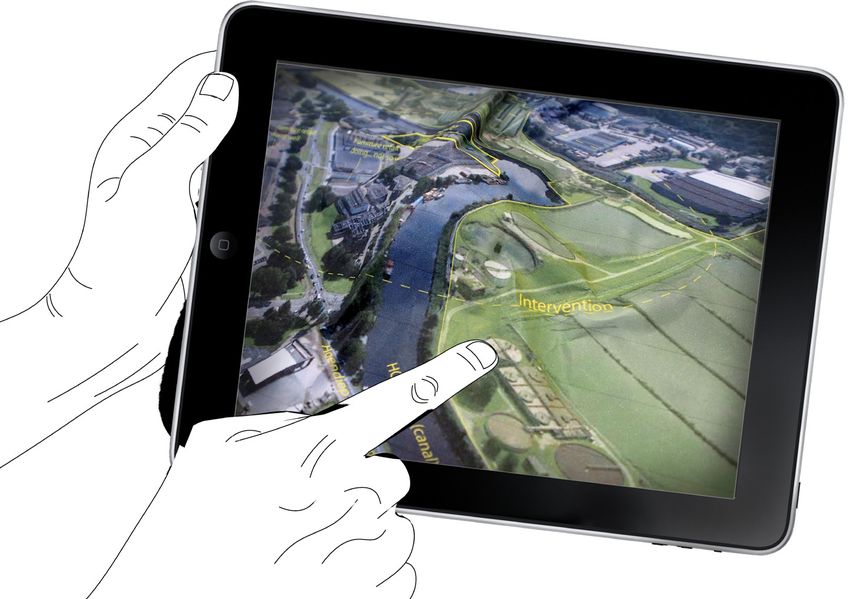
GRONINGEN (E12)
The 2008-2020 Groningen Masterplan builds its plannning on the strategic location of the city of Groningen on
the North of the Netherlands. It highlights the importance of the existing mesh of transportation networks, by
air, land and water and the necessity to further strengthen their function and inteconnectivity. Such networks                    The Sea
                                                                                                                                  30KM
allow the city of Groningen to be in constant collaboration and exchange with its neighbouring satellite cities of
Assen, Drachten, Winschoten on a regional level and the rest of the country and the world in a surpa-regional
scale.

As put forth in the programmatic description of the Masterplan, the position of Groningen on the Northern De-                                  Groningen

velopment Axis and its qualities as a national urban network provide abundant opportunities in an internation-
al, national and regional perspective. The joined vision that the Municipalities of Assen and Groningen share
the past fifteen years are a valuable asset for the future development of the area; they raise the challenge of                                                                    Winschoten

any proposal for the Europan competition site beyond the strict limits of the city of Groningen itself.                                                                            32KM

                                                                                                                       Drachten
The idea of a mini metropolis is what stimulates our thinking and drives our design proposal. To come up               42KM

with functions and urban typologies that allude to the immediate needs of the city yet share the vision of
inter-regional collaboration, of joined initiatives.                                                                                                          Assen
                                                                                                                                                              30KM

The Europan 12 competition strategic site, broadly defined as the area west of the Central Train Station, dis-
sected by the Hoendiep canal, and circumscribing the former Suikerunie factory in the south and the Furniture
Boulevard on the north, is in close proximity to a series of important urban clusters of the city, the Central Rail-
way Station area, the Historic City Center, the Stadtspark to name a few. Purely for reasons of internal organi-
zation and risk management the area has been excluded from the 2008-2020 phase of strategic planning of the
city. The competition of Europan comes to raise anew the question regarding the use of this area, its potential
to complement the strategic planning of the city so far or even to exceed it, presenting ideas that could either
conform to the hierarchical structure of the city or break away with it.

Within the broader context of Groninger as mini-Metropolis and capital of the North, we set up to explore                                   Zernike
ways in which the strategic site of the Europan area could transfrom itself from its current state as the
backyard of the city to one of its most prominent destinations and spectacles. In its former state, up to
the beginning of the demolition of the factory buildings, the site was pretty much determined, both in terms
                                                                                                                                                      Vinkuzen
of land use and identity. The ‘brutal’ act of demolition signals a turning point for the urban regeneration of the                                   Residential
site. A dense amalgam of industrial structures,the house of a very labor-intensive production process is wiped                                          Area
out, deleted as if it had never existed. The last remnants of the almost centennial history of the factory, a brick
chimney and small part of the building stand amidst a vast tabula rasa of urban land; forgotten pixels in an im-
age that seems to belong to the realm of computer graphics rather that of reality. We like to face the challenge
of such a bold intervention and set it almost as a paradigm.                                                                                                            Historic
                                                                                                                                            Terra Nova                    City

The act of removal becomes a design tool, a first necessary stage to create a new substrate to work with.
                                                                                                                                                                                     Europa
We set out a new infrastructure of interventions rather than a singular act. We think of process and the                                                                              Park
ripple effect of results. We seek foremost a new identity on which to place a barrage of design steps. We
question the meaning of the words urban innovation and experimental garden for new urban developments.                                             Stadpark
To the competition brief we answer : Does it entail The design of an iconic building as a source of inspi-
ration for area development – as has happened frequently in Groningen? Or is there rather a need here for a
more modest architectural intervention but then one that acts as a catalyst for a spectacular                                                                Martini
transformation for this part of the city. We wish to aggregate the urban mesh of Gronigen with an-                                                           Hospital
other important node,                                                                                                                                         Area

The left-over character of the site becomes its greatest premise. We respond to the brief of the competition
by laying out on this new land, this Terra Nova, the seed of multi-functionality. We wish not to overdetermine
the program at this stage, only to point out that the new land is born out of the city, its paths being the natural
extension of the streetscape, its infrastructure, physical and virtual, contributing to the extensive network of
educational and research institutions of the city.
                                                                                                                                                                                                AVON ARRET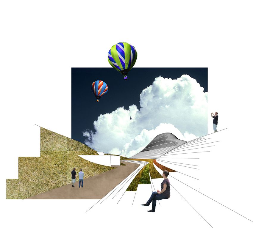
GRONINGEN (E12)

The industrial past of the area is gradu-     Following its predecessor across the canal,   A new canal is opened along the Hoendiep                     The system of roads introduced serve a                    In due time the development of the island
ally being wiped out with the exception of    the poor-performing southern side of the      Avenue. Automatically the land assumes                       dual purpose. To connect the island in                    will induce the development of the whole
one brick chimney and a small part of the     Hoendiep furniture boulevard is removed.      a new identity, that of an island. It is cut off             the best manner to its surroundings and                   region. The presence of the island alone is
former sugar factory, left over as symbolic   The only function still remaining on the      from the “mainland” only to be reconnect-                    to create a partitioning that can serve for               bound to create a raise in the land value of
landmarks.                                    island is that of KEMA factory.               ed in a stronger and most profound way.                      diverse programmatic uses. The roads are                  its surroundings. The shed-like structures
                                                                                            The center of the island becomes the pivot                   intended for bicycle, public transport and                of the Furniture District would potentially
                                                                                            point for the development of the whole                       emergency vehicles only.                                  be organized in more permanent struc-
                                                                                            surrounding area.                                                                                                      tures. A variety of new land uses, both
                                                                                                                                                                                                                   temporary and permanent will complete
                                                                                                                                                                                                                   the planning process.

                                                                                                                         We consider the ‘brittle’ nature of the Dutch landscape. A landscape inhabited under the premise of technological ingenuity,
                                                                                                                         owing its longevity to the capacity of the human intellect. Being Dutch means growing up under this fine line between the nat-
                                                                                                                         ural and the man made, the natural and the artificial, between what would naturally exist and what exists only as the desire of
                                                                                                                         man.

                                                                                                                         The Hoendiep canal is physically connected to - part of this vast technical undertaking of man. A barrier and a splendid oppor-
                                                                                                                         tunity to quote the competition organizers. To work with the canal means to take into account this vast network and consider its
                                                                                                                         importance. The fiirst act of our architectural intervention is one of hydrological nature. Through the opening up of a new canal
                                                                                                                         however we do a lot more than to reorganize slightly the stream of the water. We create a new artificial boundary, a new entity
                                                                                                                         we choose to call the island (despite the fact that all of the country is more or less islands of some sort).

                                                                                                                         By treating it as an island we automatically introduce the potential of a new identity.

                                                                                                                         Once the technological infrastructure proves stable and the threat of a natural disaster is diminished man starts to explore
                                                                                                                         further this potential marriage of nature and technology. Artificiality becomes then an axiom and a modus operandi - the natural
                                                                                                                         can never again exist without the technique. The engineers set new frontiers in the manipulation of nature to fulfil man’s desire.

                                                                                                                         Yet only the outline of the island does not suffice to grant it a new identity.

                                                                                                                         We decide to build on the idea of nature as artifice, of land as a sort of malleable piece of paper. We introduce imaginary
                                                                                                                         geological forces. Mountains are built, some made to look ‘natural’, others made to look artificial. The program is buried
                                                                                                                         underneath. Now we have the straight and the curved, the horizontal and the oblique in one. We have plateaus, valleys and
                                                                                                                         canyons, a beach and a small biotope, swimming tanks and open air theatres. And in the interior a powerhouse of knowledge,
                                                                                                                         research facilities, innovation.

                                                                                                                                                                                                                                         AVON ARRET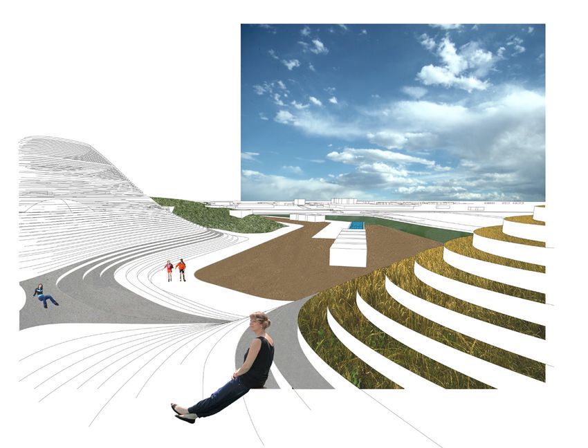
GRONINGEN (E12)
                                                            U R B A N I S L A N D We attempt a comparison between our island and other
                                                            such ‘urban islands’. We wish to point out the importance that such urban clus-
                                                            ters hold for their respective cities. In Venice, the island of Giardini, of a similar
                                                            scale, hosts annually the Venice Biennale. In Berlin the Museum Insel is a famous
                                                            destination for cultural sightseeing. In Paris the Ile se la Cite is synonymous to the
                                                            historical city center.

                                  4a

1       2              3                   4b       5       1. Terra Nova / Groningen          4a. Ile de la Cite / Paris
                                                            2. Giardini / Venice               4b. Ile Saint-Louis / Paris
                                                            3. Christianborg / Copenhagen      5. Museum Insel / Berlin

A

                                                            D E D Y N A M O S “ They are the carriers of the urban and regional economy.
                                                            They offer quality and opportunities in a national and international perspective.
                                                            These are the areas that have potential and developmental scope and are the
                                                            boosters of new developments, often with an international and inter-regional
                                                            spread.”

                                                            A. Terra Nova                      D. UMCG                       G. Central Train Station
                                                            B. Historic Center / Grote Markt   E. Zernikecomplex             H. Europapark
    B           C      D      E        F        G       H   C. Groningen Museum                F. Martini Ziekenhuis

                                                                                                                                     AVON ARRET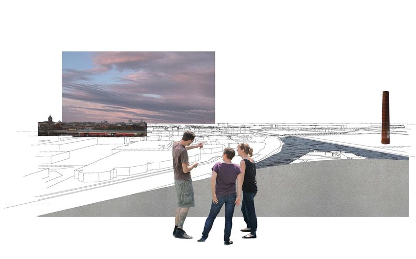
GRONINGEN (E12)

FROM MONO-LARGE TO MULTI - MIX

We consider the existing structures of the strategic site redundant.
Their poor ‘tin-box’ quality lacks identity and can only deteriorate
further. Their poor performance makes our decision lighter. The
transformation of such tin-box structures would have been possible.
Yet only as a temporary solution.

After the ground is cleared all that is left is the potential generated
from the city itself - the dynamics of the urban surroundings. We see
a ground plane full of potential. A ground that is pushed upwards to
host a diverse program. We don’t abolish the parameter of large-
ness but we push it to its extreme. We wish to create a cluster of
multiple program and users, wrapped under an iconic architectural
gesture.

                                                                          city panorama                urban terraces

                                                                                          biotope

         canyon
                                                                                                        swimming pool

                                                                                                    AVON ARRET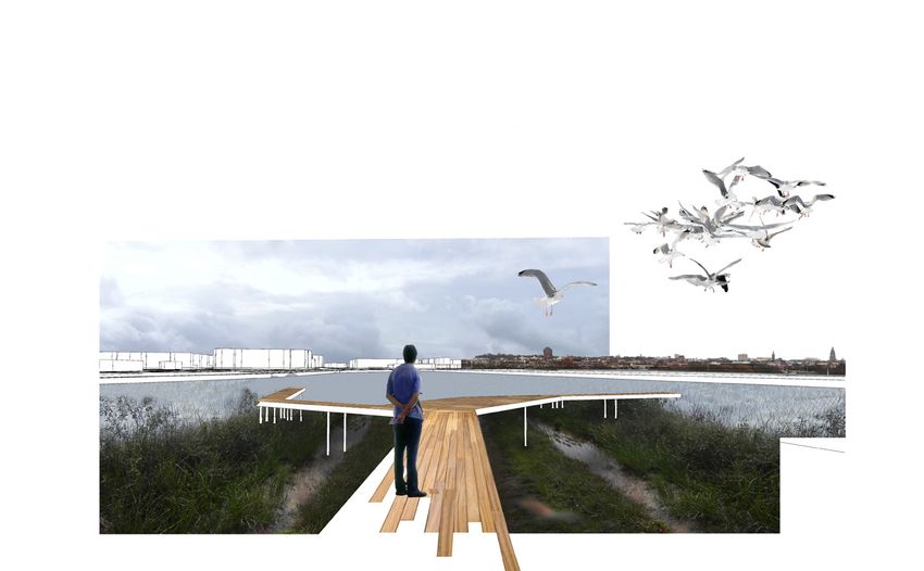
15HA
15HA
32 HA 15HA 32 HA
84HA
32HA 29HA
29HA 29HA
URBAN LANDSCAPE
GRONINGEN (E12) 15HA
15HA
32 HA 15HA 32 HA
84HA
32HA 29HA ECOLOGICAL LANDSCAPE
29HA 29HA
IDENTIFYING PROGRAM MIXING AND ADDING NEW PRO-
TYPOLOGIES ON THE SITE GRAM TYPOLOGIES AREA PROGRAM ADAPTING THE PROGRAM
DIVISION TO THE SITE
Retail RECREATIONAL LANDSCAPE
Industry
Recreation
Education
Restaurant - Lounges
run off Research
Research Facilities
IDENTIFYING THE
pavements PREDICTING THE NEW
STAKEHOLDERS
KEMA
plazas
KEMASTAKEHOLDERS
Kema Conference - Auditorium
UMCG
rooftops
bioswales
bioswales river
KEMA
Furniture Retail
FURNITURE GENERAL
irrigation of new planting
KEMA
areas
Research Facilities
RETAIL UMCG
PUBLICINITIATIVES
UMCG
cistern CULTURAL
GENERAL
General Public
FURNITURE WC water
MUNICIPALITY Energy Production Related Activities
RETAIL PUBLICCULTURAL
Municipality
INITIATIVES
Pump
Cultural Initiatives
MUNICIPALITY Gathering Space
Open Air Theatre - Urban Plazza
Electric power
Energy Production
DNV KEMA Energy & Sustainability
Separator Tubo
expander
Generator
Recuperator
WC water
Heat exchanger
Condensor
Evaporator
Thermal plant WC water
Restaurant - Lounges
Research Facilities
Geothermal Energy Diagram
cold water pimped
Steam and hot water down
run off
Library
pavements
Research Clusters
plazas
rooftops
bioswales
bioswales
river Research - Conference
irrigation of new planting
areas
Facilities
Student Areas
cistern
WC water
Pump
Water Management Diagram
AVON ARRET
GRONINGEN (E12)
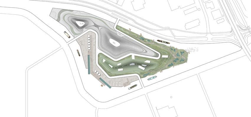
One island, broken down in three distinct zones.
Each zone assumes a different character, in terms of pro-
gram and architectural expression.
All three come together to form a coherent system that
through its diversity and multi-functionality becomes a pro-
totype of urban development
The first zone builds upon the theme of an urban landscape.
The mountains are angled, built as stepped surfaces. A
series of amphitheatres ideal for spontaneous events and a
continuous stepping up to the two plateaus, where different
views of the island and the city are offered. Partially planted,
partially hard surface this part of the island belongs more
to the city and the man-made than it does to nature. Inside
the program could follow the thematic axis of energy and
research related to energy production and sustainability. The
KEMA factory, which continues to be housed under one of
the two shells could prove to have a major role in this part of
the island.
The second zone concentrates on the theme of ecology. The
MASTERPLAN
mountain form approximates a natural mountain one can O 100m
easily climb on. This part of the island meets the water in a
soft manner. Here nature comes to develop spontaneously.
SITE SECTION
A biotope will eventually grow on today’s parking lots. Inside
multi-task research facilities could be available to students,
young professionals, start-up companies. A powerhouse of
creativity.
The third zone is purely devoted to recreation and sports.
A sand beach, large swimming pools, beach volley courts,
wellness centers. A live manifestation why Groningen is a
pioneer in the Medical and Healthy Aging sector.
AVON ARRETYou can also read