The 3D Elevation Program Update for NGAC - Vicki Lukas Chief, Topographic Data Services National Geospatial Program April 28, 2021 - Federal ...
←
→
Page content transcription
If your browser does not render page correctly, please read the page content below
+

The 3D Elevation Program
Update for NGAC

                           Vicki Lukas
                           Chief, Topographic Data Services
                           National Geospatial Program
                           April 28, 2021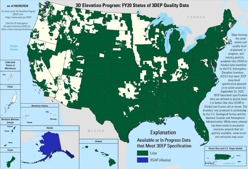
+                                                                                                                                    2
    3D Elevation Program (3DEP) Goal
    ◼   Complete acquisition of nationwide lidar (IfSAR in AK) by 2023 to provide the first-ever national
        baseline of consistent high-resolution elevation data – both bare earth and 3D point
        clouds – collected in a timeframe of less than a decade
    ◼   Address Federal, state and other mission-critical requirements
                                                                                                                          Annual Benefits
    ◼   Realize ROI 5:1 and potential to generate $13 billion/year   Rank   Business Use                              Conservative   Potential

    ◼   Leverage the expertise and capacity of private mapping         1    Flood Risk Management                           $295M         $502M
                                                                            Infrastructure and Construction
        firms                                                          2                                                    $206M         $942M
                                                                            Management
    ◼   Achieve a 25% cost efficiency gain                             3    Natural Resources Conservation                  $159M         $335M
                                                                       4    Agriculture and Precision Farming               $122M        $2,011M
    ◼   Completely refresh national data holdings
                                                                       5    Water Supply and Quality                         $85M         $156M
                                                                            Wildfire Management, Planning and
                                                                       6                                                     $76M         $159M
                                                                            Response
                                                                            Geologic Resource Assessment and Hazard
                                                                       7                                                     $52M        $1,067M
                                                                            Mitigation
    3DEP Status                                                        8    Forest Resources Management                      $44M          $62M

       2023                                                            9    River and Stream Resource Management             $38M          $87M
                                                                      10    Aviation Navigation and Safety                   $35M          $56M
                                                                       :

                                                                      20    Land Navigation and Safety                       $0.2M       $7,125M
                                                                            Total for all Business Uses (1 – 27)             $1.2B         $13B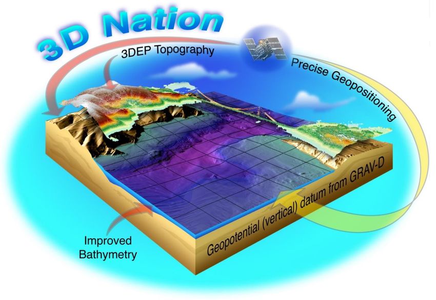
+                                                                           3
    Foundational Data Underpin Administration Priorities
    3D Elevation Program Supports…

                                              Klamath, Kootenai, and Nisqually Tribes:
                                              bathymetric lidar data for fish habitat
                                              restoration
+                                                           4
    Foundational Data Underpin Administration Priorities
    3D Elevation Program Supports…
    Infrastructure
    ◼   3DEP, NHD, and geophysical data are
        foundational and directly applicable to a broad
        range of infrastructure applications
    ◼   Data acquired have a high ROI for infrastructure
        as well as a broad range of other applications
    ◼   Data are acquired by the private sector, creating
        jobs
    ◼   Data programs are “shovel ready”
    ◼   The Federal and industry capacity exist to
        execute and deliver
    ◼   Data acquisition is easily accounted for and
        auditable
    ◼   No new O&M tail is required
    ◼   We have shown success before with ARRA – a
        proven process
+ 3DEP FY20 Summary                                         5

 Data are available or in progress for ~78% of the Nation
 *includes lidar and AK IfSAR

      Data acquisition investments by all
           partners, by fiscal year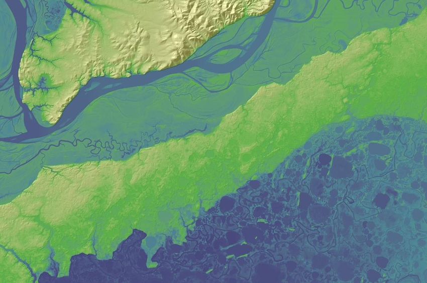
+                          6

    Statewide Completion
    Alaska IfSAR

    ▪ 100% of the State
      is complete
    ▪ Data available for
      download on The
      National Map and
      the state of
      Alaska elevation
      portal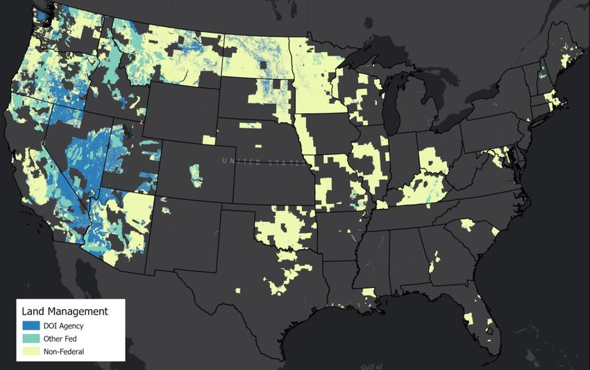
+                                                           7
    Remaining Areas
     End of FY20

       Data        Cost to     Area      % of    % of
                                                remaining
    Acquisition   Complete   (sq. mi.)   cost     area

       DOI        $67.4M     195,395 23%         22%
     Other Fed     $54.4M    124,996     19%     14%
    Non-Federal   $171.5M    555,069     59%     63%
      Total       $293.2M    875,460     100%    100%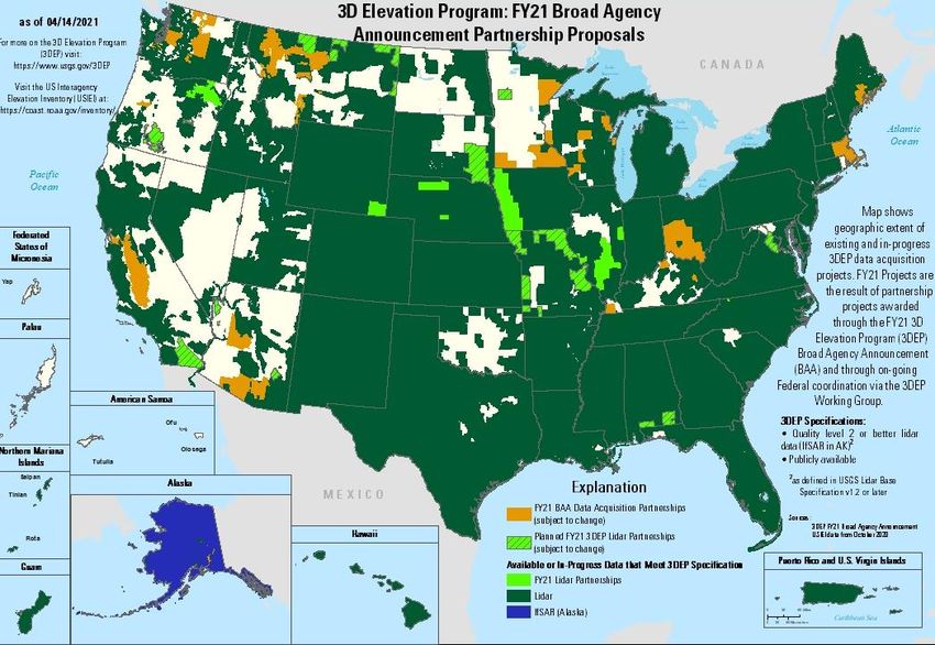
+ 8
3DEP FY21 Partnerships
Status (as of 4/14)
▪ Completed FY21 Broad
Agency Announcement
proposals
▪ Received 27 proposals in
14 states
▪ Accepted 18, shown in orange
▪ Working with Federal partners
to develop acquisition plan for
remaining funding, shown in
bright green
+                                                                                                           9

Critical Minerals and Energy Collaboration
    ■   FY20 GeoDAWN: Geoscience Data
        Acquisition for Western Nevada
        collaboration for lidar and
        aeromagnetic data collection

    ■   FY21 collaboration focused on
        California’s Imperial Valley and
        Salton Sea
        ■   DOE Geothermal Technologies Office
        ■   USGS EarthMRI, Earthquake Hazards
            Program and 3DEP
        ■   BLM
        ■   NRCS
        ■   In collaboration with California Energy
            Commission and Department of
            Conservation

    ■   Potential future collaboration for
        areas of undiscovered hydrothermal
                                                      GeoVision Study – Undiscovered Hydrothermal
                                                                       https://openei.org/apps/geovision/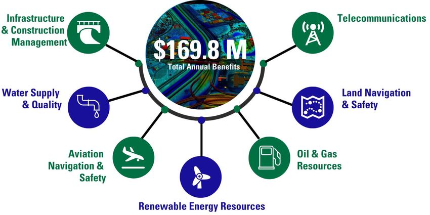
Over 300 3DEP partners including 18 Federal agencies and >250 state and local governments
+
(Partial listing)
Bureau of Indian Affairs CA Geological Survey Marion County GIS, IN Sarpy County, NE AIken County, SC Mohave County, UT
10
Bureau of Land Management CA Natural Resource Agency Hamilton County, IN NH Department of Environmental Services Anderson County, SC Bear Lake Watch
DOD - AZ National Guard CalFire Wayne County, IN NH Department of Transportation Beaufort County, SC City of Tremonton, UT
Department of Energy City of San Diego OHS, CA KS Department of Agriculture NJ Department of Environmental Charleston County, SC City of Logan, UT
Federal Emergency Management Los Angeles Regional Imagery KS GIS Policy Board Protection City of Aiken, SC City of Brigham, UT
Agency Consortium, CA KY Commonwealth Office of DE Valley Regional Planning City of Greenville, SC Fairfax County, VA
Fish and Wildlife Service San Diego County, CA Technology Commission City of North Augusta, SC Henrico County, VA
National Geospatial-Intelligence San Diego Association of KY Division of Water City of Henderson, NV Dorchester County, SC University of Virginia
Agency Governments, CA LA Coastal Protection and City of Las Vegas, NV Jasper County, SC VA Dept of Environmental Quality
National Oceanic and Atmospheric Southwest Wetlands Interpretive Association Restoration Authority Clark County Regional Flood, NV Lexington County, SC VA Information Technologies
Agency City of Montrose, CO LA Department of Transportation Clark County Water Reclamation Newberry County, SC Agency
National Park Service CO Division of Rec and Mining and Development District, NV Pickens County, SC City of Williamsburg, VA
Natural Resources Conservation CO Governor's Office of Arlington, MA Clark County, NV Richland County, SC VT Agency of Commerce and
Service Information Technology State of MA Lyon County, NV SCANA Public Utility, SC Community Development
Tennessee Valley Authority CO Water Conservation Board MassGIS Southern NV Water Authority South Carolina Lidar Consortium Columbia County
U.S. Navy Denver International Airport Baxter State Park, ME Storey County, NV 911, TN WA Dept of Natural Resources
US Army Corps of Engineers Garfield County, CO Bureau of Parks and Lands, ME University of Nevada Reno Appalachian Electric Co-op, TN Adams County, WI
US Bureau of Reclamation Gunnison County, CO Clayton Lake Woodland Holdings, LLC Washoe County, NV Arlington, TN Bayfield County, WI
USDA-ARS Town of Castle Rock, CO Cooperative Forestry Research City of Buffalo, NY City of Bartlett, TN Calumet County, WI
US Forest Service FL Division of Emergency Unit. ME International Joint Commission (IJC) City of Bristol, TN Clark County, WI
USGS Management Drinking Water Commission, ME NY State Information Technology City of Kingsport, TN Dane County, WI
AK Dept. of Natural Res. State of FL King Pine Win, ME Services City of Germantown, TN Dodge County, WI
AK North Slope Borough Martin County Engineering Dept., FL ME Bureau of Parks and Lands NY State Office of Information Hamilton County, TN Fond du Lac County, WI
City of Gustavus Northwest Florida Water ME Department of Transportation Technology Services Johnson City Metro Transportation Forest County, WI
Fairbanks North Star Borough Management District ME Office of Information City of Columbus OH Planning Organization, TN Green Lake County, WI
Golden Valley Electric Authority Osceola County, FL Office of Technology Clinton County OH City of Lakeland, TN Jefferson County, WI
Matanuska Emergency Management Seven Islands Land Company Delaware County OH Memphis Chamber of Commerce La Crosse County, WI
Metlakatla Palm Beach County, FL Washington County, ME Lucas County, OH Memphis Light, Gas and Water Lafayette County, WI
Municipality of Anchorage Seminole Tribe of Florida Charlevoix County, MI Muskingum Watershed Conservancy City of Memphis, TN Langlade County, WI
Organized Village of Kake St. Johns River Water Gratiot County, MI Drain District Metropolitan Planning Department Lincoln County, WI
Sealaska Management District Commission OH Department of Administrative Nashville Davidson County Monroe County, WI
The Nature Conservancy Suwannee River Water Little Traverse Bay Band Odawa Services City of Millington, TN Oneida County WI Land
AL Department of Economic Management District Indians Sandusky County, OH Morristown-Hamblen GIS Group Information
and Community Affairs City of Roswell, GA The Southeast Michigan Council Wood County, OH Rutherford County, TN Pepin County, WI
AL Department of Transportation GA Coastal Regional Commission of Governments City of Hillsboro, OR Shelby County, TN Portage County, WI
Chilton County, AL GA Environmental Protection State of MI City of Portland, OR Sullivan County, TN Price County, WI
Cullman County, AL Division Boone County MO Coquille Indian Tribe TN Department of Finance and Sawyer County, WI
Franklin County, AL GA Mountains Regional Metropolitan St Louis Sewer District Metro Regional Gov, OR Administration Southeastern Wisconsin Regional
Huntsville, City of Commission MS Environmental Quality OR Department of Geology and Mineral Town of Collierville, TN Planning Commission
Russell County, AL IA Department of Agriculture Department Industries Houston-Galveston Area Council Taylor County, WI
Town of Thorsby, AL and Land Stewardship NC Department of Transportation OR Water Enhancement Board Grant San Antonio River Authority City of Washburn
Tuscaloosa County, AL Nez Perce County, ID NC Department of Public Safety OR Department of Forestry TX Commission on Environmental Waupaca County, WI
Walker County, AL Cook County, IL NC Floodplain Mapping Program Umatilla Indian Reservation Quality Winnebago County, WI
AR Game and Fish Commission IL Champaign County GIS City of Blair, NE City of Allentown, PA TX Water Development Board Wisconsin Coastal Management
Northwest AR Regional Consortium City of Fremont, NE PA Turnpike Commission Williamson County Program
Planning Commission IL Department of Natural Resources City of Lincoln-Lancaster County, NE PA Department of Environmental UT Division of Emergency Illinois Height Modernization
Pulaski County Area GIS, AR IL State Geological Survey City of Omaha, NE Protection Management Program
Coconino County, AZ Kane County, IL Douglas County, NE PA Department of Transportation UT Geological Survey MI Dept of Environmental Quality
Pima Association of Governments, AZ Lake County, IL NE Office of the Chief PA Dept of Conservation and Natural UT Forestry, Fire, and State Lands MI Department of Technology,
C A Department of Water Resources McHenry County, IL Information Officer Resources Moab City, UT Management and Budget
Papio Missouri River Natural PA Emergency Management Agency Wasatch Ski Resorts Natrona County, WY
Resources District Susquehanna River Basin Commission Tooele Army Depot Capitol Region Council of
Tri-County Regional Planning Bryce Canyon History Governments
Commission, PA Riverdale City, UT County of Hawaii
Puerto Rico Planning Board Park City, UT Waushara County, WI+ 11
3D Elevation Program (3DEP)
Governance
■ USGS and NOAA co-lead the OMB A-16 Elevation Theme Member Agencies
■ 3DEP Executive Forum Bureau of Land Management
Department of Homeland Security
■ Facilitates executive collaboration on strategies to fund and implement 3DEP
Department of Transportation
for the benefit of all its stakeholders
Environmental Protection Agency
◼ Executive Outreach to Industry Partners and Stakeholder Groups Federal Aviation Administration
Federal Communications Commission
■ Provides direction to 3DEP Working Group
Federal Emergency Management Agency
■ 3DEP Working Group - Coordinates implementation of 3DEP US Forest Service
US Fish and Wildlife Service
National Oceanic and Atmospheric Administration
National Park Service
Natural Resources Conservation Service
Office of Surface Mining Reclamation and Enforcement
US Department of Agriculture
US Army Corps of Engineers
US Geological Survey
American Association of State Geologists
National States Geographic Information Council+ 12
Accelerating the 3DEP Unified Plan
Refining and Strengthening Federal and State Best Practices+ 13
National Landslides Preparedness Act (P.L. 116-323)
Authorizes the 3D Elevation Program and Establishes Governance
◼ In addition to the 3DEP Subcommittee under NGAC, the act stablishes a 3DEP
Federal Interagency Coordinating Committee, chaired by the Secretary of the Interior
in coordination with the Secretary of Commerce and the Secretary of Homeland
Security including:
◼ Agriculture
◼ Commerce
◼ Homeland Security
◼ National Science Foundation
◼ Office of Science and Technology Policy
◼ Office of Management and Budget
◼ The head of any other Federal department or agency, at the request of the Secretary
◼ Within a year, the coordinating committee will develop a strategic plan and a
management plan to implement the strategic plan+ 14
National Landslides Preparedness Act (P.L. 116-323)
Goals for 3DEP FICC and NGAC Subcommittee
◼ Merge/evolve 3DEP Executive Forum with/to the FICC; ensure that the 3DEP Working Group is linked in
◼ Encourage engagement at highest levels of DOI, DHS and DOC and listed agencies; invite new agencies to
participate
◼ Evolve towards broader coordination for the future direction of the 3D National Topography Model (3DNTM)
◼ Potential topics for both groups
◼ New applications, partnerships
◼ Funding
◼ What creative funding options should we be looking at to complete nationwide coverage?
◼ How can we fund completion of Federal lands where the agencies do not have 3DEP funding?
◼ Feedback on products and services delivery
◼ Future directions
◼ Input on the 3D National Topography Model
◼ Recommendations on research and future implementation of the 3D data model+ 3DEP Future Generation Just Around the Corner 15
3D Nation Elevation Requirements and Benefits Study
◼ Working with NOAA to understand inland, nearshore and offshore bathymetric data requirements and
benefits
◼ Plan for the next round of 3DEP when the first-ever national baseline of consistent high-resolution data is in
place – what is needed for monitoring, change detection and other new applications?
◼ Gather technology-agnostic user information to be able to assess new technologies against requirements
and identify the tradeoffs between different approaches
◼ Results will lead to a
completely new approach
regarding QLs, refresh
frequency by geography,
products offered, and other
changes+ 16
3D Nation
Building a modern elevation foundation – from the peaks of our
mountains to the depths of our waters – for stronger, more resilient
communities and U.S. economy
◼ To be relevant in the 21st century accurate 3D
maps are a requirement for a GPS-enabled
Nation
◼ Maps, including geodetic and elevation data,
must be accurate to within centimeters
◼ A national mapping framework must be
continuous
◼ Our citizens increasingly expect coordinated
and integrated products17
3DNTM:
+ Next Generation of Integrated Data 17
Topography is defined by elevation and hydrography; elevation shapes hydrography, and hydrography shapes
elevation. To support a broad range of applications, the 3D National Topography Model integrates USGS
elevation and hydrography datasets to model the Nation's topography in 3D.
Next Generation NHD: 3D Hydrography Program
(3DHP)
◼ Operationalize deriving hydrography from lidar/IfSAR
◼ Enable better accounting of the hydrologic cycle by adding
connections to groundwater, engineered hydrologic
systems and wetlands
◼ Fully implement the National Hydrography Infrastructure
as the universal mechanism for sharing and discovering
water information
Next Generation 3D Elevation Program (3DEP)
◼ Operationalize inland bathymetry
◼ Collect new data based on landscape change, evolving
user needs and technology, vegetation structure
◼ Enable monitoring and change detection by comparing
baseline with new vintages of data18
3DNTM:
+ Supports the Nation’s Critical Applications 18
z
Topography is defined by elevation and hydrography; elevation shapes hydrography, and hydrography shapes
elevation. To support a broad range of applications, the 3D National Topography Model integrates USGS
elevation and hydrography datasets to model the Nation's topography in 3D.
▪ Delivers the terrestrial component of
the 3D Nation vision of a continuous
data surface from the depths of the ▪ Provides universal discovery and sharing
oceans to the peaks of the mountains of water information as the geospatial
foundation for the Internet of Water
▪ Enables new and emerging applications
▪ Provides foundational data to critical initiatives
▪ Multiple vintages enable change
▪ FEMA Future of Flood Risk Data and Risk detection
Rating 2.0
▪ Water-related applications move
▪ The National Water Model from the neighborhood to the street-
▪ The Clean Water Act level in accuracy
▪ National Landslides Preparedness Act
▪ Underpins a broad range of applications
including flood risk management, hazards
response and mitigation, infrastructure
management, climate change science, and more+ THANK YOU! 19
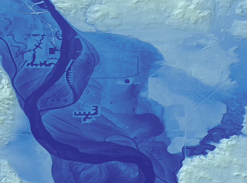
Bismarck, ND
3D Elevation Program (3DEP)You can also read