The Carolina Slate Belt - John J. W. Rogers
←
→
Page content transcription
If your browser does not render page correctly, please read the page content below
Chapter 2
The Carolina Slate Belt
John J. W. Rogers
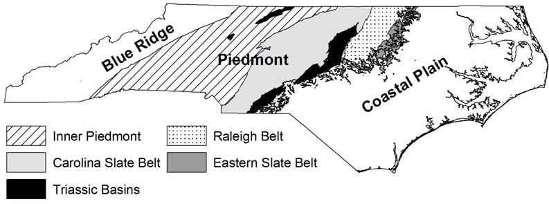
The hilly Piedmont of North Carolina separates the flat Coastal Plain and Triassic-Jurassic
rift basins from the mountainous Blue Ridge and Appalachians (Figure 2.1). The Coastal Plain
consists of Mesozoic-Cenozoic sediments developed on the subsiding continental margin as the
North Atlantic Ocean became wider, and the Triassic-Jurassic rift basins are filled mostly by
sedimentary debris washed into rifts formed during the initial stages of opening of the Atlantic
Ocean. The Raleigh Belt and Eastern Slate Belt (see alternative terminology in Hibbard et al.
2002) contain rocks similar to those of the Piedmont. These suites, however, are exposed mostly
east of the Triassic-Jurassic basins, and their connection with the Piedmont is unclear. This
study does not include the rift basins, whose rocks are unsuitable for manufacturing artifacts, and
also omits the Raleigh and Eastern Slate belts.
The Piedmont can be divided into eastern and western areas dominated by two very different
rock suites. The eastern part, the focus of this study, is the Carolina Slate Belt, and the western
part is known as the Inner Piedmont. Some geologists group the Carolina Slate Belt and Inner
Piedmont as a Carolina Terrane, but others restrict the term Carolina Terrane to include only the
Carolina Slate Belt. Information about the Carolina Slate Belt and other terranes in a large
region east of the Appalachians referred to as the “Carolina Zone” is in Hibbard et al. (2002).
The Carolina Slate Belt consists mostly of rocks originally deposited on or near the earth’s
surface by volcanic eruption and sedimentation (North Carolina Geological Survey 1985). This
area is referred to as the Carolina Slate Belt because low-grade metamorphism has given many
of the rocks a slaty cleavage. The area is cut in several places by coarse-grained intrusive rocks,
generally termed granites, that are relatively undeformed because they apparently intruded
following the metamorphism that affected the sedimentary and volcanic rocks.
The Inner Piedmont mostly contains metamorphosed intrusive rocks that now occur as
various types of gneiss. This area is eliminated from the present study, partly because of its
greater distance from Fort Bragg, but mostly because the rocks in it are unsatisfactory for making
stone tools.
The entire Piedmont is underlain at a depth of about 20 km by a zone that strongly reflects
seismic waves. This zone is generally regarded as a fault or series of faults along which the
upper block, including the exposed part of the Piedmont, moved westward over a suite of almost
completely unknown rocks. The fault may bend upward to the west and come to the surface as
one of the numerous thrusts in the Appalachian Mountains, although exact correlation of any of
these faults eastward under the Piedmont has thus far been impossible.
10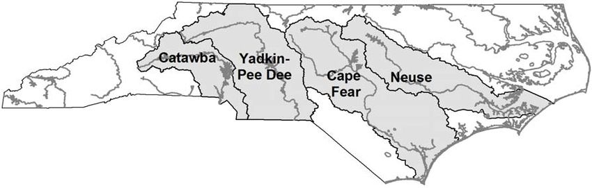
THE CAROLINA SLATE BELT

         Figure 2.1. Major geologic regions of North Carolina (Rogers 1999; North Carolina Geological
         Survey 1998).

                                             Ancient History

     A very few of the sedimentary rocks of the Carolina Slate Belt in South Carolina contain
fossils of Cambrian age (about 500 million years old). They are referred to as “Gondwanan”
because they resemble Cambrian fossils found in the southern continents rather than those in
North America. These fossils and those in other blocks along the eastern edge of North America
show that a series of terranes (known as “Avalonian”) were close to the western margin of South
America 500 million years ago and moved to collide (“dock”) with eastern North America at a
later time.
     Several questions about the docking of the Carolina Slate Belt are unresolved. One is
whether the Carolina Slate Belt was an independent block or whether it was fused with the Inner
Piedmont to form a larger Carolina Terrane before docking. A further question is the time at
which docking occurred. Metamorphism presumably occurred during collision, but the post-
metamorphic granites are about 300 million years old and presumably were emplaced after
docking. The 20-km-deep fault zone beneath the Piedmont probably developed during western
movement of the Carolina Terrane, although that cannot be proven.
     The Carolina Slate Belt contains two rock suites: the Uwharrie Mountains contain rocks
referred to as either the Uwharrie suite or the Albemarle suite (Figure 2.2); the Virgilina suite
comprises the rest of the Carolina Slate Belt outside of the Uwharrie Mountains. Both suites
probably began to form while the Carolina Slate Belt was near South America and continued to
develop as the terrane moved across the intervening ocean basin to North America (Harris and
Glover 1988; Rogers 1999). Rocks of the Uwharrie suite appear to have been deposited in a rift
in a microcontinent that may already have separated from South America before the internal
rifting occurred. Rocks of the Virgilina suite probably developed as a primitive island arc on
oceanic lithosphere. Virgilina rocks are slightly older than Uwharrie rocks, and the time and
mechanism of joining of the Virgilina and Uwharrie suites is uncertain.

                                               Rock Types

    Very little of the rock in the Carolina Slate Belt consists of sediment eroded from continental
land masses. Rather, development primarily in an ocean basin caused the generation of silicic

                                                     11
ROGERS
Figure 2.2. Geologic features in the vicinity of the Uwharrie Mountains (North Carolina Geological
Survey 1998). The named formations in the right-hand column of the legend comprise the Uwharrie suite.
volcanic rocks that are high in sodium (Na) and low in potassium (K). Consequently, the
volcanic rocks of the Carolina Slate Belt consist mostly of quartz and plagioclase and contain
very little K-feldspar. An official geologic term for these rocks is “dacite,” but older geological
and all archaeological literature refers to them as “rhyolite.” The term “felsite,” which includes
any high-silica volcanic rock, is also sometimes used.
12THE CAROLINA SLATE BELT
A small proportion of the rocks of the Carolina Slate Belt are low-silica basalts whose origin
is unclear. They are useful for bowls and bannerstones but are too soft to be used for stone tools
and are not considered in this report.
Dacitic volcanism in the Carolina Slate Belt generated rocks deposited by an enormous
variety of processes. The resulting diversity of rock types is best displayed in the well-exposed
Uwharries region, and similar processes undoubtedly formed all of the other volcanic and
sedimentary rocks in areas of the Carolina Slate Belt where exposures are poor.
Most rocks were formed by consolidation of fragments blown out of volcanoes. These
fragments include a few broken pieces of crystals but mostly consist of glass formed by rapid
cooling of liquid blobs. Angular glass fragments are referred to as “shards.”
Fine-grained ash accumulations are called “tuff” and include rocks formed by at least three
different processes. One such process is consolidation of steam-saturated ash clouds, which
travel at speeds up to 100 km/hour at temperatures of higher than 600°C. Thick ash clouds retain
so much heat that the interiors may remelt (“vitrify”) after consolidation to form thinly layered
rocks that are very hard. The black rock at the quarry site at Morrow Mountain probably formed
from a thick ash cloud. Another process by which tuff forms is through accumulation, either on
land or in water, of ash blown through the air. Tuffs formed in this way are finely layered, but
because they accumulate after cooling they do not become vitrified. They are probably useful as
stone tools only after metamorphism or some other secondary process. Finally, a third process
resulting in the formation of tuff is the accumulation of ash and larger fragments moved by water
or wind. Sedimentary rocks formed through this process are hard enough to be used for tools
only after metamorphism or other secondary processes.
Rocks formed from liquid flows are rare. They contain various proportions of quartz and
plagioclase phenocrysts, and some show a crude flow banding.
All of the rocks in the Carolina Slate Belt have undergone low-grade metamorphism that
converted most of their original minerals except quartz to lower-temperature assemblages.
Metamorphic minerals commonly include chlorite, epidote, stilpnomelane, and smaller amounts
of numerous other minerals (with at least one occurrence of the rare mineral piedmontite).
Stratigraphy
Stratigraphic relationships have been determined for the Uwharrie suite in the Uwharrie
Mountains but are virtually unknown elsewhere in the Carolina Slate Belt. Even in the
Uwharries, stratigraphic thicknesses are uncertain because the base of the sequence is unexposed,
an unknown amount of rock has been eroded from the top, and deformation obscures
relationships within the exposed section. This discussion follows the stratigraphy proposed by
Milton (1984; cf. North Carolina Geological Survey 1998).
The lowermost unit in the Uwharrie Mountains is the Uwharrie Formation, a sequence of
silicic flow and volcaniclastic rocks. The Uwharrie Formation is overlain by the Tillery
Formation, consisting mostly of planar-laminated silicic siltstones and mudstones that may
represent the distal parts of turbidites that episodically filled the Uwharrie basin. The Cid
Formation, above the Tillery, appears to have been deposited in comparatively shallow water. It
consists largely of silicic debris in beds 10-40 cm thick, with cross stratification in the lower part
and thin laminations toward the top. The Flat Swamp member of the Cid Formation is
distinguishable by its assemblage of silicic flows and ignimbrites. The Floyd Church Formation,
13ROGERS
above the Cid, consists almost wholly of mudstones whose clay contents give rocks a higher K
content than is found in other rocks in the Uwharrie suite. The uppermost unit is the Yadkin
Formation, which consists of poorly sorted sandstones that include abundant grains of basaltic
rocks. One distinguishable unit of the Yadkin Formation is the Badin greenstone, which contains
a few basaltic flow rocks but consists mostly of sand- and silt-sized grains of basaltic rock. The
Morrow Mountain ignimbrite and the identical rocks of Tater Top Mountain may be the same
age as the Yadkin Formation, but their stratigraphic position is unclear because they may
represent the deposits of volcanoes that were injected through an unknown sequence of other
rocks in the Uwharrie Mountains.
Ages of Uwharrie rocks are poorly constrained. All of them are probably younger than 600
million years, and discovery of the Ediacaran fossil Pteridium in the Floyd Church Formation
suggests that most deposition in the North Carolina part of the Carolina Slate Belt occurred
before the end of the Proterozoic.
Topography and Human History
The Piedmont in North Carolina is about 200 m higher than in South Carolina and Virginia.
This high elevation results from the Cape Fear Arch, an uplift that trends roughly along the Cape
Fear River and continues on a linear trend through the Piedmont into the Appalachians. Drill
cores and geophysical studies in the Coastal Plain show that the Arch has been an uplift for at
least the past 250 million years, and studies of modern river patterns show that the Arch has risen
nearly one half meter since human habitation began some 12,000 years ago (Rogers 1999).
The high elevation in North Carolina causes rivers to flow either north or south from the
Piedmont rather than directly eastward (Figure 2.3). Only two rivers with tributaries in the
interior of the Piedmont (Cape Fear and Neuse) remain wholly within North Carolina until they
reach the Atlantic Ocean. Two other systems (Yadkin and Catawba) flow into South Carolina,
and one river system (Dan) flows north into Virginia before it turns south in the Coastal Plain to
reach the ocean in North Carolina.
The high elevation in North Carolina prevented the establishment of a simple fall line
between the Piedmont and Coastal Plain. The fall line is easily seen in Virginia and South
Carolina, where the cities of Richmond and Columbia are built along it. North Carolina,
Figure 2.3. North Carolina rivers and drainage basins mentioned in the text (United States Department
of Agriculture 1998).
14THE CAROLINA SLATE BELT
however, has a broad fall zone more than 100 km wide over which rivers lose about 200 m of
elevation. This difference in fall zones explains why river transportation by all types of ships is
possible across the entire Coastal Plain to the Piedmont in both South Carolina and Virginia, but
even powered vessels can get no farther upstream than Fayetteville in North Carolina.
The greater elevation and lack of fall line in North Carolina has had a profound effect on
human history (Rogers 1999). The inability of people in the North Carolina Piedmont to
communicate freely with the Coastal Plain led to isolation of early Piedmont inhabitants. Most
early settlers in the Piedmont arrived by wagon roads through Virginia instead of from coastal
North Carolina. Until the development of railroads in the 1800s, Piedmont inhabitants traded
with the ports of Richmond and Charleston instead of with North Carolina ports. In colonial
time, the isolation caused numerous rebellions, including the activities of the Regulators shortly
before the American Revolution.
Because the headwaters of the Cape Fear and Neuse River basins are at high elevations, these
rivers and their tributaries have cut deeply incised valleys. Floodplains would have been narrow
or absent during most of human history, except during the eighteenth through early twentieth
centuries when widespread deforestation accompanying the development of farms allowed the
valleys to be temporarily choked by runoff debris. The lack of floodplains causes even modern
highways to follow routes between rivers instead of along the rivers.
It is not known whether the high elevation of the North Carolina Piedmont and the lack of
floodplains along its rivers affected transportation in prehistoric times. Without pack animals or
wheeled vehicles, people walking along trails may have crossed between the Piedmont and the
Coastal Plain just as easily as they would have walked within either the Piedmont or the Coastal
Plain. An indirect indication of this possibility is that the Cherokee trading path led through the
Appalachians in North Carolina, where they are the highest, whereas colonial wagon roads
passed through lower parts of the mountains in Virginia or Georgia.
Comparison of the stone tools at Fort Bragg with rocks at quarry sites in the North Carolina
Piedmont will help resolve the question of whether prehistoric groups crossed the fall zone
consistently. If they did, then it should be possible to correlate Fort Bragg projectile points with
specific quarries in the Piedmont. An absence of correlation may suggest that people traveled
farther north or south along the Coastal Plain looking for more accessible quarry sources.
15You can also read