Preliminary assessment of the potential for particle trajectory modelling to support ocean search and rescue operations
←
→
Page content transcription
If your browser does not render page correctly, please read the page content below
Preliminary assessment of the potential for particle trajectory modelling to support
ocean search and rescue operations
M.G. Hart-Davis a, b, c * and B.C. Backeberg b, d
a
  Institute for Coastal and Marine Research, Nelson Mandela University, Port Elizabeth, South
Africa
b
  Nansen-Tutu Centre for Marine Environmental Research, University of Cape Town, Cape
Town, South Africa
c
  Egagasini Node, South African Environmental Observation Network, Cape Town, South
Africa
d
  Nansen Environmental and Remote Sensing Center, Bergen, Norway
* now at Deutsches Geodätisches Forschungsinstitut, Technische Universität München, Munich,
Germany
Abstract. Finding a person (or object) lost at sea is like looking for a needle in a haystack. The ability to provide
more precise search area coordinates for rescuers to conduct their searches will help optimise search and rescue
operations. A particle trajectory model for at sea search and rescue applications is presented. The model
incorporates the effects from wind, surface currents, as well as stochastic diffusivity in order to determine the
horizontal trajectory of each virtual particle released. Two scenarios are presented based on real-life search and
rescue scenarios which occurred along the coastline of South Africa. These scenarios demonstrate the abilities of the
particle trajectory model in search and rescue operations for varying object types and in different regions of the
Greater Agulhas System.

1. Introduction

Objects lost at sea are subject to forcing from ocean        based on the object type and position in the water
currents, winds and waves. How much an object is             column. The improved ability of numerical models to
influenced by these processes depends on the                 make estimations about the ocean state has resulted in
object's characteristics. Each year numerous                 these models being increasingly used to estimate the
incidents, varying from ships sinking and colliding,         pathway of objects in the ocean. Several tools have been
recreational and professional marine activities and          created to account for the type of object being tracked in
objects falling overboard, occur in the world’s open         order to better understand their drift (Breivik et al.,
oceans and in the coastal regions. In South Africa, a        2011, Hart-Davis et al., 2018a). The tools presented in
significant part of these incidents involves the             (Breivik et al., 2011, Hart-Davis et al., 2018a)
National Sea Rescue Institute (NSRI) which, in               independently combine the use of particle tracking and
2017, conducted 1,050 rescue operations (NSRI,               the leeway object divergence methodology presented in
2018). This resulted in the rescuing of 1,224 people         Chapter 5 of (Allen and Plourde, 1999). Lagrangian
and 2,723 hours of operational activity (NSRI,               analyses of ocean fluids from virtual particles, advected
2018). In order to reduce operation times and costs          with the background flow information from ocean
and to improve the overall quality of operations,            models, have been increasingly used to study physical
several new and innovative techniques have been              and biogeochemical oceanographic processes (van
developed. In search and rescue operations, the              Sebille et al. 2018). The tool has broad and diverse
focus is on estimating the search area based on a            application to a variety of objects (including persons)
number of factors and computing the evolution of             lost at sea, with great potential for optimising search and
the search area over time (Breivik and Allen, 2008).         rescue operations in the future. Here we demonstrate the
These factors include physical forces that would act         usefulness of using a virtual particle tracking tool forced
on an object such as winds, currents and waves. The          with ocean and wind forecast data and adjusted for
complexity increases when computing the motion of            windage using empirical relationships provided by the
different objects with varying shapes in the ocean           NSRI to predict the trajectories of objects lost at sea in
(Breivik and Allen, 2008). Initial techniques looked         two separate scenarios.
at the current wind direction and magnitude, making
a rough estimation on the position of the object

                                                                                       NANSEN-TUTU 2021 | PAGE 52
2. Data and method                                        The ECMWF produces operational ensemble-based
                                                          analyses and predictions that cover time frames ranging
Particle Trajectory Model                                 from medium-range, to monthly and seasonal, and up to
Particle tracking is the observation of the motion of     a year ahead. These are available to its Members and the
an individual particle within a fluid. Particle           Co-operating States, as well as through licenses via the
tracking uses a Lagrangian modelling framework            World Meteorological Organization (WMO) and the
that moves with the flow of the ocean and is particle     academic and commercial sectors. The South African
specific instead of being point specific (MacDonald       Weather Service routinely receives these forecast data.
et al. 2006). In the case study presented here, a         Here, the 3-hourly 1/10º wind forecasts 10m above the
Lagrangian particle tracker known as Parcels              ocean surface are averaged to daily mean winds and
(“Probably A Really Computationally Efficient             interpolated to the 1/12º Mercator ocean forecast grid to
Lagrangian Simulator”) (Lange and van Sebille             obtain consistent spatio-temporal resolution between the
2017) was used. Parcels is a virtual particle tracking    ocean and wind forecasts products used to advect
tool aimed at exploring novel approaches for              Parcels.
Lagrangian tracking of virtual ocean particles
(Lange and van Sebille 2017). Parcels requires            Case studies
gridded velocity data to compute the Lagrangian
trajectories of virtual particles. Here, virtual          Capsized Catamaran
particles were forced using both ocean surface            On 14 December 2014 Anthony Murray (58), Reginald
currents from the operational Mercator global ocean       Robertson (59) and Jaryd Payne (a 20-year-old first-
analysis and forecast system and global surface wind      time sailor) set sail from Cape Town to deliver a luxury
forecasts from the European Centre for Medium-            catamaran (a Moorings A5130, Sunsail RC044-978) to
Range Weather Forecasts (ECMWF). Additionally,            Phuket, Thailand. Tragically, they were last heard from
the response of the virtual particles to winds, known     on 18 January 2015 approximately 2190 Nautical Miles
as windage (uwind), was incorporated based on wind        north-west of Perth, Australia, and after multiple
drift tables made available by the NSRI. For the two      attempts to establish their whereabouts, the catamaran
case studies, the following windage parameters were       was reported missing by the Maritime Rescue
used: Capsized Catamaran: uwind x 0.04 and Rigid          Coordination Centre (MRCC) in Cape Town on 11
Inflatable Boat: (uwind x 0.03) + 0.08.                   February 2015 and the search and rescue activities were
                                                          officially closed on 15 May 2015. Approximately 1 year
Operational ocean current and wind forecasts              after the search was called off, on the 18th of January
                                                          2016 a Brazilian Navy Ship, Amazonas, spotted the
The operational Mercator global ocean analysis and        upturned hull approximately 113 Nautical Miles off
forecast system provides 10-day 3D global ocean           Cape Recife, near Port Elizabeth, South Africa. 5 days
forecasts on a daily basis. This 3D product includes      later on 22 January 2016, the National Sea Rescue
daily files of temperature, salinity, currents, sea       Institute (NSRI) found the capsized catamaran south of
level, mixed layer depth and sea ice parameters. It       Cape Agulhas. Unfortunately, while the tug, the Peridot,
also includes hourly mean surface fields for sea level    was towing the capsized catamaran back to Cape Town,
height, temperature and currents. The global ocean        the tow line broke (due to adverse sea conditions) and
output files are available at a 1/12º horizontal          the catamaran was lost.
resolution     with    regular     longitude/latitude     However, the approximate locations of the vessel being
equirectangular projection and 50 vertical levels         spotted off Cape Recife (25° 41' 59.46"E and 34° 24'
ranging from 0 to 5500 meters. The ocean model is         11.08"S) and being found off Cape Agulhas (20° 07'
forced using winds from the ECMWF (European               32.58"E and 35° 01' 31.94"S) provide a good case study
Centre for Medium-Range Weather Forecasts)                to test the application of virtual particle tracking tools in
Integrated Forecast System, which are also the            search and rescue applications.
winds used to account for the wind drift of the virtual
particles. The ocean current data are available from      Rigid Inflatable Boat
the Copernicus Marine Environment Monitoring              At 17h03 on the 4th of June 2019, the NSRI were
Service.                                                  activated following reports of a vessel that had lost
                                                          power within False Bay in Cape Town, South Africa.

                                                                                    NANSEN-TUTU 2021 | PAGE 53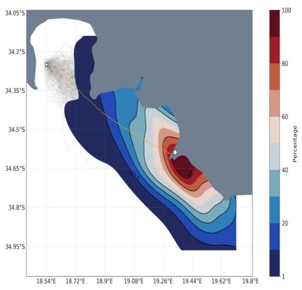
Figure 1: A simulation of 1000 virtual particles deployed at the location where the (left) capsized vessel and (right)
rigid inflatable boat were last seen (white circle). The color bar represents the time in days since deployment of the
virtual particles. The orange dots represent the mean trajectory of the 1000 particles with the white star indicating
the position where the objects were eventually found. The black and blue contours respectively represent the mean
winds and surface currents over the period for which the particle trajectory model was run.

Figure 2: Density plots of the final position of the virtual particles. The grey lines represent all the trajectories of
the 1,000 virtual particles, with the orange line representing the mean trajectory.

                                                                                          NANSEN-TUTU 2021 | PAGE 54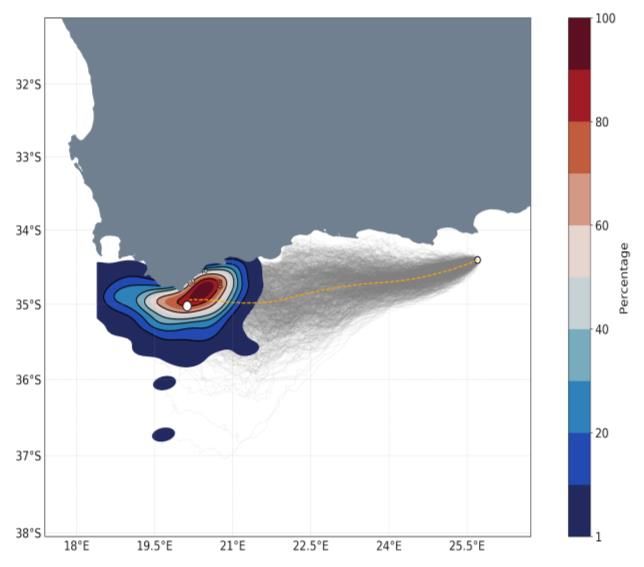
The vessel was a five-meter rigid inflatable boat that       information could be used to inform search and rescue
was last seen near Roman Rock, at 34° 10' 48'S and 18°       operations in terms of optimising their search efforts to
27' 36''E, with an unknown number of people on board.        those regions.
After an extensive search in strong winds and heavy
seas, the vessel was later recovered almost two days         4. Discussion and Conclusion
later on the south coast near a beach known as
Gaansbaai (19° 20' 05.11'' E / 34° 35' 19.14''S). The        It is shown that, by incorporating wind and surface
complexity of this scenario due to the vessel containing     current data into the particle trajectory model, the
sailors on board as well as due to the heavy sea             model predicts the drift of the two different objects to a
conditions provides an extremely challenging scenario        reasonable degree of accuracy. Incorporating the
to assess the ability of the particle trajectory model in    impacts of stochastic motion into the model facilitates
real-life scenarios.                                         a spread of trajectories (Figure 1 & 2). By then
                                                             calculating the mean trajectory and density distribution
3. Results                                                   of the virtual particles (Figure 2) highlights the ability
                                                             of the particle trajectory model to estimate the location
The particle trajectory model was used in two different      where the objects were found with a relatively high
search and rescue scenarios to assess its ability in         degree of confidence. There remains scope for
estimating the trajectory of objects lost at sea. For each   improvement however, in particular the global wind
scenario, one thousand virtual particles were deployed       and ocean forecast models used in both scenarios are
at the location where the object was last seen (Figure       not optimised for regional or near coastal applications,
1). Each virtual particle, incorporated windage to           the latter requires careful downscaling to the requisite
account for the characteristics of the object (capsized      fine coastal scales (Kourafalou et al., 2015). Despite
vessel and inflatable boat respectively) following the       this the test cases demonstrate the need to combine both
Leeway approach presented in Allen and Plourde               wind and ocean currents correctly when simulating
(1998). The virtual particles were deployed for the          trajectories of different types of objects lost at sea.
duration that the object was lost at sea and the particles   Moreover, the application demonstrates skill in open
were forced by the Copernicus surface current data and       ocean as well as near coastal environments under
ECMWF 10m wind product. In each scenario, the                different dynamical ocean conditions, despite
effects of stochastic motion were applied to the virtual     limitations in the global reanalysis and forecast
particles to account for the unresolved physical process     products used to force the particle trajectory model.
not present in the forcing data (van Sebille et al 2018).    Addressing limitations of the global reanalysis and
Figure 1 shows the trajectories of all virtual particles     forecast products, this study highlights the importance
deployed for both case studies. The orange dots              of using appropriate parametrization for sub-grid scale
represent the mean of all trajectories and the stars         processes when using these data to force particle
indicate the position where the two objects were             trajectory models applied to search and rescue.
eventually located by the NSRI. Additionally, the mean       Additionally, accurate positions of the objects' initial
currents and winds for the duration of the simulation        conditions (in time) is a critical factor. Future work to
experiments with Parcels are overlaid. It is evident from    further improve the accuracy of the application includes
these figures that wind plays an important role in           adding tidal currents, Stokes drift, as well as
determining the trajectories of the virtual particles. The   incorporating improved drift responses of different
parameterised stochastic motion accounting for sub-          objects, taking into consideration both ocean currents
grid scale effects is responsible for the spread of the      and winds. Furthermore, integration with traditional
trajectories. Calculating the mean of these and taking       search and rescue workflows will further enhance
into consideration the position where the two objects        support for search and rescue operations.
were found, highlights the importance of adding
stochastic motion to the virtual particles in terms of       References
determining accurate search area coordinates. Using
the data from the 1,000 virtual trajectories, one can
                                                             Allen, A. A. and Plourde, J. V. (1999). Review of
calculate the density of the particles for each time step
                                                             leeway: field experiments and implementation.
and contour these on a map. Figure 2 shows the density
                                                             Technical report, Coast Guard Research and
of the virtual particles in percentage of the total
                                                             Development Center Groton CT.
particles deployed for both case studies. The areas
outlined by, for example the 90% contour, indicate
regions where virtual particles accumulate. This

                                                                                      NANSEN-TUTU 2021 | PAGE 55
Breivik, Ø. and Allen, A. A. (2008). An operational
search and rescue model for the Norwegian Sea and the
North Sea. Journal of Marine Systems, 69(1-2):99–113.
Breivik, Ø., Allen, A. A., Maisondieu, C., and Roth, J.
C. (2011). Wind-induced drift of objects at sea: The
leeway field method. Applied Ocean Research,
33(2):100–109.
Hart-Davis, M. G., Backeberg, B. C., Halo, I., van
Sebille, E., and Johannessen, J. A. (2018a). Assessing
the accuracy of satellite derived ocean currents by
comparing observed and virtual buoys in the Greater
Agulhas Region. Remote Sensing of Environment,
216:735–746.
Kourafalou, V.H., P. De Mey, J. Staneva, N. Ayoub, A.
Barth, Y. Chao, M. Cirano, J. Fiechter, M. Herzfeld, A.
Kurapov, A.M. Moore, P. Oddo, J. Pullen, A. van der
Westhuysen & R.H. Weisberg (2015) Coastal Ocean
Forecasting: science foundation and user benefits,
Journal of Operational Oceanography, 8, 147-167,
DOI: 10.1080/1755876X.2015.1022348
Lange, M. and van Sebille, E. (2017). Parcels v0. 9:
prototyping a Lagrangian ocean analysis framework for
the petascale age. Geoscientific Model Development,
10, 4175-4186.
NSRI (2018). Key Rescue Statistics from 2017. NSRI.
Van Sebille, E., Griffies, S. M., Abernathey, R.,
Adams, T. P., Berloff, P., Biastoch, A., Blanke, B.,
Chassignet, E. P., Cheng, Y., Cotter, C. J., et al. (2018).
Lagrangian ocean analysis: Fundamentals and
practices. Ocean Modelling, 121:49–75.
NANSEN-TUTU 2021 | PAGE 56You can also read