A Tale of Two Storms: Surges and Sediment Deposition from Hurricanes Andrew and Wilma in Florida's Southwest Coast Mangrove Forests
←
→
Page content transcription
If your browser does not render page correctly, please read the page content below
A Tale of Two Storms: Surges and Sediment Deposition
from Hurricanes Andrew and Wilma in Florida’s
Southwest Coast Mangrove Forests

By Thomas J. Smith III, Gordon H. Anderson, and Ginger Tiling

     Hurricanes can be very different from each other. Here
we examine the impacts that two hurricanes, Andrew and
Wilma, had in terms of storm surge and sediment
deposition on the southwest coast of Florida.
Although Wilma was the weaker storm, it
                                                                                       at landfall,
had the greater impact. Wilma had the
                                                                              the highest category, but its
higher storm surge over a larger area
                                                                                 eye was surprisingly small, only
and deposited more sediment than
                                                                                      some 20 mi (32 km) across. Wilma
did Andrew. This effect was
                                                                                          was a category 3 at landfall but had
most likely due to the size of
                                                                                              an eye over 80 mi (128 km) wide,
Wilma’s eye, which was
                                                                                                 four times the size of Andrew’s
four times larger than
                                                                                                    eye. The storms came from
that of Andrew.
                                                                                                      opposite directions, and
                                                                                                        both impacted important
                                                                                                          resources along
Introduction                                                                                               Florida’s southwest
                                                                                                             coastline (fig. 1).
     Hurricanes                                                                                                    This coastal
can be as different                                                                                           area has large tracts
from each other as                                                                                            of mangrove forests.
people are. Some                                                                                              These forests are to
hurricanes are small                                                                                          south Florida what
and compact; wound                                                                                           salt marshes are to
up tight, they are                                                                                          the northern Gulf of
lean, mean, fighting                                                                                       Mexico and Atlantic
machines. Others are                                                                                     coasts. Mangroves
big and wide; you could                                                                                 provide habitat for
almost call them portly.                                                                              endangered species such
Hurricane Andrew in August                                                                          as roseate spoonbills (Ajaia
1992 was the former, and                                                                         ajaja) and American crocodiles
    Hurricane Wilma in October                                                                (Crocodylus acutus). Mangroves
             2005 was the latter. Andrew                                                   are the food base that supports
                      was a category 5 storm                                           important commercial and recreational
                                                                                  fisheries including snook (Centropomus
                                                                             undecimalis), tarpon (Megalops atlanticus),
                                                                         mangrove snapper (Lutjanus griseus), and red drum
                                                                  (Sciaenpos ocellatus). The thick root systems of mangrove
                                                              forests trap and bind sediment, thus aiding in stabilizing
                                                              shorelines. Mangrove ecosystems clearly provide goods and
                                                              services to human society (Ewel and others, 1998; Gilbert and
170   Science and the Storms: the USGS Response to the Hurricanes of 2005

Janssen, 1998). Unfortunately, throughout most of the world,          Climate Change project (Smith, 2004). By the time of Wilma,
mangrove forests are being cleared for a variety of coastal           hydrologic monitoring stations had been set up at a number
developments including ports, housing, and aquaculture ponds          of sites (fig. 1). At these sites we have hydrology-monitoring
(Valiela and others, 2001).                                           wells for both surface and ground water, sediment surface
      The passage of two such large hurricanes in a relatively        elevation tables (SETs), marker horizons, and permanent
short time span (13 years) allows scientists to begin asking          vegetation plots (see Ward and Smith, this volume).
questions concerning their multiple effects or cumulative                   The hydrology stations employ standard U.S. Geological
impacts. Additionally, we know that sea level is rising in            Survey (USGS) methods and equipment for measuring water
south Florida (Maul and Martin, 1993). Thus we have the               elevation and conductivity. Changes in sediment-surface
opportunity to study the interactions between disturbance and         elevation have been measured with sediment SETs, simple
sea-level change. People cannot manage what they do not               devices that can accurately measure relative changes in
understand; therefore, proper management of these valuable            elevation over time (Boumans and Day, 1993). Sediment
forests is dependent on a sound scientific understanding of           marker horizons have been established that allow us to
their ecology, including how mangrove forests respond to              measure deposition of sediment in the forest. Marker horizons
natural disturbances such as hurricanes.                              are simply a layer of colored material (e.g., sand or brick
                                                                      dust) that is placed on the sediment surface (Wood and others,
                                                                      1989); as material is deposited on top of the marker horizon, it
                                                                      can be easily measured.
Studying Hurricane Impacts                                                  Following the passage of tropical storms or hurricanes,
                                                                      we conduct rapid assessments to ascertain impacts. For
      We began intensive research in the southwest coastal            many storm systems these impacts are hardly perceptible.
Everglades immediately after Hurricane Andrew in August               For example, after Hurricane Katrina (a weak category 1
1992. The Mangrove Hydrology Sampling Network was                     system when it was in Florida) passed over our study sites, we
initiated following Andrew as part of the South Florida Global determined negligible impacts on the environment (although
                                                                                                  one hydrology station was damaged
                                                                                                  and one in northeast Florida Bay was
                                                                                                  destroyed). Experience told us that as
                                                                                                  Wilma approached, however, things
                                                                                                  would be different. Immediately
                                      EGC
                                                                                                  after this storm we resampled our
                                                                                                  sediment SETs, conducted surveys of
                                                                                                  storm surge, and measured sediment
                                                  CH3                                             deposition. These data gave us a
                                                                                                  chance to compare Andrew and
                                                      SOB                                         Wilma and also to begin examining
                     LRS                                                                          the cumulative impacts of large
                                                        LO3
                     HLB                                                                          hurricanes on mangrove forests.
                                                                                                        Storm surge is the water that is
                                 SH4                                                              pushed towards the shore by storm-
                                                                 SH2
                                                                                                  related winds. The surge combines
                               SH3                                                                with tides and may reach levels of
                                                                                                  15–20 ft (4.6–6 m) or more above
                                                                                                  normal levels. Storm surge is the
                                                                                                  greatest threat to human life during
                            BSC
                                                                                                  hurricanes (see http://www.nhc.noaa.
                                                                     BLF                          gov/HAW2/english/storm_surge.
                                                                                                  shtml to learn more about storm
                                                                                                  surges). Storm surges carry material
Figure 1. The southwest Florida coast is shown in this satellite mosaic from 1994. The            as they move inland, and this material
approximate positions of the northern and southern eyewalls of Hurricane Andrew (1992)            includes sediment. Sediment is often
(purple arrows) and Hurricane Wilma (2005) (blue arrows) are shown. Abbreviations for             deposited in recognizable layers that
locations mentioned in the text are as follows from north to south: EGC, Everglades City;         scientists can find years after the
CH3, Chatham River 3; SOB, Second Onion Bay; LRS, Lostmans River Ranger Station; LO3,             storm has passed and use to assess
Lostmans River 3; HLB, Highland Beach; SH4, Shark River 4; SH2, Shark River 2; SH3, Shark hurricane impacts (Kang and Trefy,
River 3; BSC, Big Sable Creek; and BLF, Black Forest.                                             2003).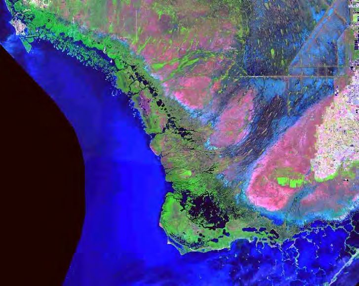
A Tale of Two Storms: Surges and Sediment Deposition from Hurricanes Andrew and Wilma 171
Comparing Andrew and Wilma
Storm Surge from Andrew
Rappaport (1993) reported that, as Andrew exited the
southwest coast of Florida, storm surges of 4–5 ft (1.2–1.5
m) were observed at Flamingo (near Black Forest (BLF in
fig. 1)) and of 6–7 ft (1.8–2.1 m) at Everglades City (EGC in
fig. 1). Mayfield and others (1994) estimated a storm surge
of 5–7 ft (1.5–2.1 m), along a very short segment of coast, as
Andrew exited southwest Florida. There were no hydrologic
monitoring stations present on the southwest coast at the time
of Andrew, so Mayfield’s estimates are based on the results of
hydrological models.
Storm Surge from Hurricane Wilma
In contrast, we estimate that storm surge from Wilma
was in excess of 15 ft (4.6 m). We know this fact based on
observations of debris found stranded in the mangrove forests
that Wilma flooded. At Big Sable Creek (BSC in fig. 1), debris
was found 10 ft (3 m) up in the remains of the mangrove
forest canopy (fig. 2). No evidence of storm surge was found
at this site following Andrew. Weight of the logs had bent the
stems upon which they rest, so our estimates are most likely
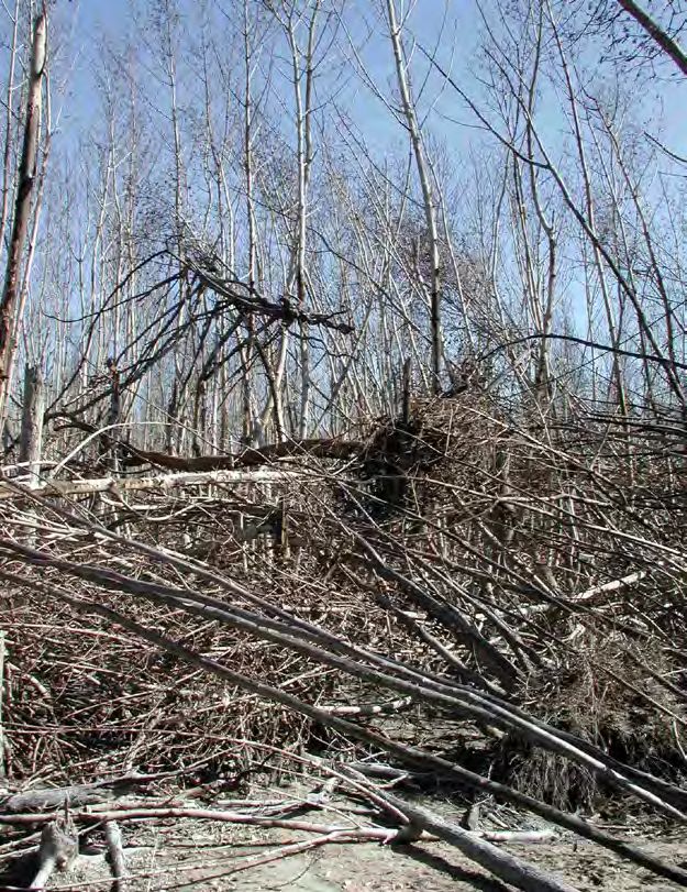
low. Some 15 mi (24 km) to the north, at Highland Beach Figure 2. Debris pile (purple arrow) some 10 ft (3 m) above the
(HLB) we found entire trees suspended in the remains of the forest floor at Big Sable Creek (BSC), Fla., after Hurricane Wilma
mangrove forest canopy, approximately 9–15 ft (2.7–4.6 m) in 2005. The weight of the debris bent down the stems on which it
above the soil (fig. 3). came to rest (blue arrow).
At the nearby Lostmans River 3 hydrology
station (LO3), we found sediment deposited on the
top of the box housing the destroyed instruments,
an elevation of 8 ft (2.4 m). At the Lostmans River
Ranger Station (LRS), debris was observed 8–10 ft
(2.4–3 m) high in the mangrove forest. The ranger
station itself was a wooden structure on low pilings
that survived the leading and trailing eyewalls of
Hurricane Andrew. The building sat on a barrier
beach some 15 ft (4.6 m) above sea level. It was
entirely swept away by the surge from Wilma (fig.
4).
Further north at EGC, National Park Service
personnel reported a storm surge of 6–7 ft (1.8–2.1
m). At BLF, our southernmost site (located 1.5 mi
(2.4 km) inland from the coast), sediment stains on
vegetation indicated flooding of 2 ft (0.6 m).
Our stage height gages revealed that a clear
gradient is from north to south along the coast Figure 3. This photograph was taken in the Highland Beach (HLB), Fla.,
with the three southern stations being overtopped permanent vegetation plot, some 12 mi (19.2 km) north of Big Sable Creek
by the storm surge and lost (fig. 5). Data from just (BSC), Fla., after Hurricane Wilma in 2005. Entire trees have been washed
prior to instrument failure, however, indicate just from the barrier dune and swept into the mangrove forest where they were
how quickly water levels were rising. At BSC the stranded in the remains of the canopy. Tree trunks have been deposited some
water level went from -4.665 to 2.515 ft (-1.422 15 ft (4.6 m) (blue arrow) and 9 ft (2.7 m) (purple arrow) above the forest floor.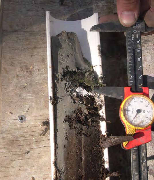
172   Science and the Storms: the USGS Response to the Hurricanes of 2005

                                                                                           to 0.767 m), the last recorded data point, in 3 hours (the
 A                                                                                         minus signs indicate that water levels were below mean sea
                                                                                           level). A gradient is also seen in the reduction of the surge as
                                                                                           it propagated upstream in the Shark River (stations BSC and
                                                                                           SH2–SH4 in figs. 1 and 6). The two downstream stations were
                                                                                           lost, but the recovered data indicate the rapid increase in stage.
                                                                                           At Shark River 4 (SH4), 12 mi (19.3 km) upstream from the
                                                                                           gulf, the peak water level was approximately 3.3 ft (1.0 m),
                                                                                           and at Shark River 2 (SH2), 16.5 mi (26.5 km) upstream, the
                                                                                           peak was reduced to only 1.2 ft (0.4 m) (fig. 6).

                                                                                           Sediment Deposition
                                                                                                  Risi and others (1995) conducted a detailed survey of
 B                                                                                         sediment deposition following Andrew. They found storm
                                                                                           deposits distributed from Highland Beach south to Shark
                                                                                           Point, an 8-mi (13-km) length of coastline. Deposits from
                                                                                           Andrew did not reach further than 6.25 mi (10 km) inland.
                                                                                           By our estimates, deposits from Andrew influenced 44 mi2
                                                                                           (114 km2) of mangrove forest. Following Wilma, we found
                                                                                           little or no sediment deposition at sites immediately adjacent
                                                                                           to the shoreline (BSC, HLB, LRS). In fact, resampling of our
                                                                                           SETs at the BSC site revealed that erosion of the mudflats had
                                                                                           occurred that was equal to the previous 7 years.
                                                                                                  Deposition from Wilma (fig. 7) was found along the
                                                                                           Lostmans River (LO3), in Second Onion Bay (SOB), south
                                                                                           to the Shark River and along all the tidal rivers in between.
                                                                                           Deposits were maximal (2–6 inches (5–15 cm)) from 1 to 3
                                                                                           mi (1.6 to 4.8 km) upstream and then decreased until they
Figure 4. Lostmans River Ranger Station (LRS) in Florida in
                                                                                           terminated some 8 mi (13 km) upstream from the Gulf of
January 1998 (A), well after Hurricane Andrew (which hit in 1992),
                                                                                           Mexico. The total area impacted by Wilma’s storm deposits
and in October 2005 (B), just after Hurricane Wilma.
                                                                                           was 110 mi2 (285 km2), 2.5 times larger than the area affected

                                                Coastal stations during Hurricane Wilma, from north to south
                                                      CH3*                   LO3*                     SH3                   BSC
                                 6
          Water level, in feet

                                 4

                                 2

                                 0

                                 -2

                                 -4

                                 -6
                                      Oct. 22, 2005          Oct. 23, 2005          Oct. 24, 2005           Oct. 25, 2005         Oct. 26, 2005

                                                                                Date
Figure 5. Data recovered from four coastal stations in the Mangrove Hydrology Sampling Network. From north to south they are
Chatham River 3 (CH3); Lostmans River 3 (LO3); Shark River 3 (SH3); and Big Sable Creek (BSC) and cover a distance of 25 mi (40 km).
BSC is located in a tidal creek some 50 yd (46 m) away from the spot where the photograph in figure 2 was taken. Data for SH3 and BSC
are referenced to the North American Vertical Datum of 1988 (NAVD88) in which zero (0.0) is approximately mean sea level. (*Data from
CH3 and LO3 have not yet been converted to NAVD88.)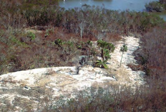
A Tale of Two Storms: Surges and Sediment Deposition from Hurricanes Andrew and Wilma   173

                                 Downstream to upstream on the Shark River system during Hurricane Wilma
                                                BSC                   SH3                     SH4                   SH2
                           6
         Height, in feet

                           4

                           2

                           0

                           -2

                           -4

                           -6
                                Oct. 22, 2005         Oct. 23, 2005         Oct. 24, 2005           Oct. 25, 2005         Oct. 26, 2005
                                                                             Date
Figure 6. Additional data from stations in the Mangrove Hydrology Sampling Network. These four stations make up a downstream
(Big Sable Creek (BSC)) to upstream (Shark River 2 (SH2)) gradient in the Shark River drainage system of the Everglades, Fla. Stations
SH2–SH4 are in vegetated wetlands adjacent to tidal rivers. All data from these stations are referenced to the North American Vertical
Datum of 1988 (NAVD88).

by Andrew. Although the deposition of 3–6 inches (7.6–15
cm) of sediment does not sound like much, when the volume
of this thin layer is calculated for the large area over which it
was deposited, the result is approximately 2.1 million dump
truck loads, a lot of sediment.

Weaker Storm with Bigger Impacts
     Our preliminary findings clearly indicate that Wilma,
a category 3 storm, had a greater impact on the southwest
Florida mangrove coastline than did Andrew, a category 4
storm when it exited the coast (Landsea and others, 2004). As
indicated earlier, storms are different. As Andrew crossed the
south Florida Peninsula and exited into the Gulf of Mexico,
it was losing strength (Landsea and others, 2004). As Wilma
approached the coastline, it was gaining strength over the
warm gulf waters (Pasch and others, 2006). Also, the eye
of Wilma was over four times the size of Andrew’s eye, so
destructive winds and surge were much more widespread.
     Field observations and data collection will continue in
our pursuit of a greater understanding of hurricane impacts on
important coastal ecosystems.

                                                                                   Figure 7. Sediment deposition at site Shark River 3 (SH3) in
Acknowledgments                                                                    Florida. The white marker horizon (purple arrow) was laid down
                                                                                   approximately 8 months prior to Hurricane Wilma. The blue
     Numerous individuals have assisted in our research on                         arrow points to a layer of mangrove leaves that was deposited
hurricane impacts over the past decade, including S. Beeler,                       first and then covered by mud (green arrow) that was swept
S. Cleaves, G. Peery, L. Romero, C. Walker, G. Ward, and K.                        in and dropped by the storm surge. Leaves from all three
Whelan. Funding has been provided through the Ecosystems                           Florida mangrove species (Avicennia germinans, Laguncularia
Program of the USGS, the National Park Service’s Hurricane                         racemosa, and Rhizophora mangle) are present in the leaf layer.
174   Science and the Storms: the USGS Response to the Hurricanes of 2005

Andrew program and Critical Ecosystems Studies Initiative,        Smith, T.J., III, 2004, Development of a long-term sampling
and the National Science Foundation (grant DEB-9306317).            network to monitor restoration success in the southwest
Comments from W. Nuttle and V. Engel improved the                   coastal Everglades—vegetation, hydrology, and sediments:
manuscript and are gratefully acknowledged.                         U.S. Geological Survey Fact Sheet FS-2004-3015, http://
                                                                    sofia.usgs.gov/publications/fs/2004-3015/

                                                                  Valiela, I.A., Bowen, J.L., and York, J.K., 2001, Mangrove
References                                                          forests—one of the world’s threatened major tropical
                                                                    environments: BioScience, v. 51, p. 807–815.
Boumans, R., and Day, J.W., Jr., 1993, High precision             Wood, M.E., Kelley, J.T., and Belknap, D.F., 1989, Patterns of
  measurement of sediment elevation in shallow coastal areas       sediment accretion in the tidal marshes of Maine: Estuaries,
  using a sedimentation-erosion table: Estuaries, v. 16, p.        v. 12, p. 237–246.
  375–380.

Ewel, K.C., Twilley, R.R., and Ong, J.E., 1998, Different kinds
  of mangroves forests provide different goods and services:      Contact Information
  Global Ecology and Biogeography Letters, v. 7, p. 83–94.
                                                                  Thomas S. Smith III, Research Ecologist (tom_j_smith@usgs.gov); and
Gilbert, A.J., and Janssen, J., 1998, Use of environmental
                                                                     Ginger Tiling, Geologist, ETI Professionals, Inc. (gtiling@usgs.gov)
  functions to communicate the values of a mangrove
                                                                  U.S. Department of the Interior
  ecosystem under different management regimes: Ecological
                                                                  U.S. Geological Survey
  Economics, v. 25, p. 323–346.
                                                                  Florida Integrated Science Center
Kang, W.J., and Trefy, J.H., 2003, Retrospective analysis of      600 4th St. South
  the impacts of major hurricanes on sediments in the lower       St. Petersburg, FL 33701
  Everglades and Florida Bay: Environmental Geology, v. 44,
  p. 771–780.                                                     Gordon H. Anderson, Hydrologic Technician
                                                                     (gordon_anderson@usgs.gov)
Landsea, C.W., Franklin, J.L., McAdie, C.J., Beven, J.L.,
                                                                  U.S. Department of the Interior
  II, Gross, J.M., Jarvinen, B.R., Pasch, R.J., Rappaport,
                                                                  U.S. Geological Survey
  E.N., Dunion, J.P., and Dodge, P.P., 2004, A reanalysis of
                                                                  Florida Integrated Science Center
  Hurricane Andrew’s intensity: Bulletin of the American
                                                                  Everglades National Park Field Station
  Meteorological Association, v. 85, p. 1699–1712.
                                                                  40001 State Road 9336
Maul, G.A., and Martin, D.M., 1993, Sea level rise at Key         Homestead, FL 33034
 West, Florida, 1846-1992: America’s longest instrument
 record?: Geophysical Research Letters, v. 20, p. 1955–1958.

Mayfield, M., Avila, L.A., and Rappaport, E.N., 1994, Atlantic
 hurricane season of 1992: Monthly Weather Review, v. 122,
 p. 517–538.

Pasch, R.J., Blake, E.S., Cobb, H.D., III, and Roberts, D.P.,
  2006, Tropical cyclone report—Hurricane Wilma: National
  Oceanic and Atmospheric Administration, National
  Hurricane Center, http://www.nhc.noaa.gov/pdf/TCR-
  AL242005_Wilma.pdf

Rappaport, E., 1993, Preliminary report: Hurricane Andrew
  16-28 August 1992: National Oceanic and Atmospheric
  Administration, National Hurricane Center, http://www.nhc.
  noaa.gov/1992andrew.html

Risi, J.A., Wanless, H.R., Tedesco, L.P., and Gelsanliter, S.,
  1995, Catastrophic sedimentation from Hurricane Andrew
  along the southwest Florida coast: Journal of Coastal
  Research, Special Issue 21, p. 83–102.
You can also read