The PMI Africa IRS (AIRS) Project
←
→
Page content transcription
If your browser does not render page correctly, please read the page content below
The PMI Africa IRS (AIRS) Project
           Indoor Residual Spraying (IRS)
                  Task Order Six

SUPPLEMENTAL ENVIRONMENTAL ASSESSMENT
       FOR IRS NATIONWIDE IN KENYA, USING
PYRETHROIDS, CARBAMATES, ORGANOPHOSPHATES, AND
  CHLORFENAPYR (WHEN RECOMMENDED BY WHOPES)
             CALENDAR YEARS 2017-2021

            APPROVED: DECEMBER 2016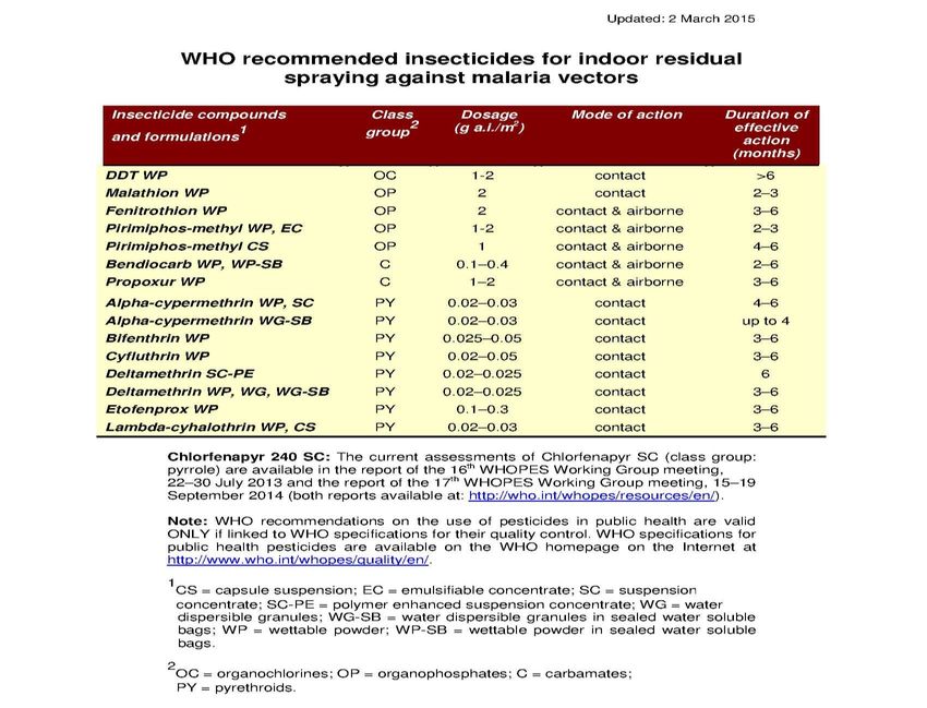
Recommended Citation: The PMI Africa Indoor Residual Spraying (AIRS) Project.
Supplemental Environmental Assessment: January 2017, Bethesda, MD. The PMI AIRS
Project, Abt Associates Inc.
Contract and Task Order Number 6: AID-GHN-1-00-09-00013 & AID- OAA-TO-14-00035
Submitted to: The United States Agency for International Development/President’s
               Malaria Initiative
The views expressed in this document do not necessarily reflect the views of the United
               States Agency for International Development or the United States
               Government.

            Abt Associates Inc. 1 4550 Montgomery Avenue 1 Suite 800 North

            1 Bethesda, Maryland 20814 1 T. 301.347.5000 1 F. 301.913.9061
            1 www.abtassociates.com
Table of Contents
Acronyms ...................................................................................................................................... iii
Executive Summary ..................................................................................................................... iv
Principal Proposals & Clearance ................................................................................................. vi
1     Background & Purpose .......................................................................................................... 1
2     Proposed Action and Alternatives ....................................................................................... 8
3     Affected Environment ......................................................................................................... 10
4     Environmental & Health Impacts ....................................................................................... 26
5     Pesticide Procedures ........................................................................................................... 31
6     Safer Use Action Plan .......................................................................................................... 45
7     References ............................................................................................................................ 53
Annex A: Environmental Mitigation & Monitoring Plan ......................................................... 54
Annex B: EMMR Form ................................................................................................................ 58
Annex C: Stakeholder Consultations ........................................................................................ 62
Annex D: Summary of Acute Exposure Symptoms & Treatment of IRS Pesticides ........... 64

                                                                                                                                                  i
Table of Tables Table 1-1: IRS Structures Sprayed per Sub-County/County in Kenya .................................... 2 Table 5-1: WHOPES Recommended Pesticides With Effective Duration ............................ 32 Table 5-2: Insecticide Resistance Tests, 2016 (% mortality) ................................................... 33 Table 5-3: Pesticide Toxicity to Non-Target Species............................................................... 36 Table of Figures Figure 1-1: Past PMI Spay Areas .................................................................................................. 5 Figure 1-2: 2017 Scope of PMI IRS in Kenya ............................................................................... 7 Figure 3-1: Kenya Administrative Units ..................................................................................... 11 Figure 3-2: Kenya Annual Average Precipitation................................................................... 14 Figure 3-3: Kenya Landcover .................................................................................................... 15 Figure 3-4: Kenya Waterbodies................................................................................................. 18 Figure 3-5: Protected Areas In Kenya ...................................................................................... 19 Figure 3-6: Map of parks and reserves in Kenya .................................................................... 23 Figure 6-1: Emergency Response to a Spill ............................................................................. 47 ii
ACRONYMS
AIRS     Africa Indoor Residual Spraying Project
CDC      Centers for Disease Control and Prevention
COR      Contracting Officer’s Representative
DDT      Dichlorodiphenyltrichloroethane
EC       Environmental Compliance
ECO      Environmental Compliance Officer
EMMP     Environmental Mitigation & Monitoring Plan
EMMR     Environmental Mitigation & Monitoring Report
IP       Implementing Partner
IRS      Indoor Residual Spraying
LLIN     Long-lasting insecticide-treated nets
MCU      Malaria Control Unit
NEMA     National Environmental Management Authority
NMCP     National Malaria Control Program
PMI      President’s Malaria Initiative
PPE      Personal protective equipment
SEA      Supplemental Environmental Assessment
SOP      Spray Operator
UNHCR    United Nations High Commissioner for Refugees
USAID    United States Agency for International Development
WHO      World Health Organization
WHOPES   World Health Organization Pesticide Evaluation Schemes

                                                                  iii
EXECUTIVE SUMMARY
This document has been prepared to serve as the Supplemental Environmental Assessment (SEA) for
Indoor Residual Spraying (IRS) in Kenya for the calendar years 2017-2021. Previous environmental
documentation for PMI-supported IRS in Kenya authorized the use of the pyrethroid, carbamates and
organophosphates classes of the WHOPES-recommended pesticides within Nyanza Province from 2009
to 2016, and was prepared in accordance with the provisions of USAID 22 CFR (216) regarding the use
and application of pesticides. This SEA proposes to reauthorize the use of the same three classes of
WHOPES-recommended insecticides, and to expand the authorization to include the use of
chlorfenapyr (when recommended by WHOPES or attains WHO prequalification). This SEA also seeks
to authorize nationwide geographical coverage of PMI-supported IRS and also requests authorization for
small-scale, closely-supervised hut trials using new IRS insecticides, such as chlorfenapyr, once the
insecticide has been submitted for Phase III WHOPES evaluation and country-level required
documentation has been submitted.
Kenya was selected as a PMI focus country in FY 2007. Malaria is a major public health problem in
Kenya. Although dramatic progress in malaria control was made in earlier years with the combination of
IRS and distribution of LLNs, the NMCP has experienced some challenges in conducting IRS in recent
years. As a result, malaria accounts for an estimated 18% of outpatient consultations and 10% of hospital
admissions based on data from the routine health information system.
Changing or rotating insecticides of different classes over time is a leading way to manage insecticide
resistance. In Kenya, entomological monitoring has demonstrated that local mosquitoes have developed
some level of resistance to the pyrethroid class of insecticides, which has been the only class of
insecticide used for IRS prior to 2016. A switch of IRS insecticides to the organophosphate, pirimiphos
methyl, will begin in Migori County starting in February 2017.
The proposal to include chlorfenapyr is prompted by the need to increase the options for
recommended insecticides available for spray activities. Chlorfenapyr, an active ingredient (AI) in the
pyrrole chemical class is under WHOPES review and if recommended for use will offer an additional
option for insecticide rotation during the approved period of this SEA.
This SEA for IRS in Kenya outlines the monitoring and mitigation measures that will be employed by the
PMI Implementing Partner (IP) to minimize or reduce the unintended adverse impacts of pesticide
application. Those measures are found in the Safer Use Action Plan (Section 6), and summarized in the
Environmental Mitigation and Monitoring Plan (EMMP) found in Annex A. All PMI IRS operations in
Kenya will be performed according to the protocols and procedures found therein. These procedures
do not change with the use of different classes of authorized pesticides, with the following exceptions:
1. The potential cumulative effects of organophosphate exposure (e.g., cholinesterase depression)
require increased emphasis and training on the ability and responsibility of team leaders and
senior personnel to daily monitor the appearance and behavior of their team members, and to
recognize the symptoms of organophosphate exposure, in order to implement the appropriate
response protocols. Biomonitoring is not required for the use of pirimiphos methyl formulations
for IRS at the present time, but increased vigilance is essential.
2. Pirimiphos methyl formulations are supplied in plastic bottles, which if not controlled carefully
may be used inappropriately once emptied of the insecticide formulation. In addition,
ivincineration of the bottles may cause harmful emissions. Because of these potential problems,
the following procedures and protocols have been established:
a. A triple rinse for the plastic bottles has been incorporated during the insecticide make
up procedure, whereby the insecticide container is emptied into the spray tank and then
three times it is partially filled with clean make-up water, capped, shaken, and emptied
into the spray tank. This ensures that the insecticide is used more efficiently, the
container is thoroughly rinsed of pesticide, and it is safe for handling and subsequent
processing. The risk of exposure due to insecticide residue in the container is essentially
eliminated; however, the following procedure is also followed.
i. Recycling programs have been established to turn the plastic into usable
products. As long as a suitable recycling program is available, through close
supervision and chain of custody, and in partnership with the Kenya National
Malaria Control Program (NMCP), the IP will ensure that the plastic remains
segregated from other materials, and is recycled appropriately.
The PMI IP will implement the EMMP in Annex A, with guidance from PMI and NMCP, and with the
assistance and involvement of the local communities. All senior staff in charge of implementation of IRS
will be trained to monitor operations when in the field, in order to maximize supervisory oversight and
ensure effectiveness of the mitigation measures during spraying operation. County coordinators will
monitor environmental compliance during the IRS campaign. The IP completes the annual EMMR Form
in Annex B, and submits it to USAID along with the annual end of spray report.
On an annual basis, a letter report will be submitted to the BEO (regional and pillar). It must contain
information regarding program changes, entomological/resistance monitoring results and data, and
program response to those results. It should also contain the results of environmental monitoring and
how the program will improve any areas of deficiency. In the year that a new SEA is prepared and
approved, the Letter Report is unnecessary.
The following assessment draws heavily on the Programmatic Environmental Assessment (PEA) for
Integrated Vector Management (IVM), updated in September 2012, and many other references, as
indicated in this document.
vPRINCIPAL PROPOSALS & CLEARANCE
1. The Kenya Supplemental Environmental Assessment (SEA) (2008), as amended in 2011
(amendment #1) and 2013 (amendment #2), was valid for implementing PMI-supported IRS in
selected regions of Kenya, using all WHO-recommended pesticides in the pyrethroid, carbamate
and organophosphate classes for the period 2009-2016.
2. In order to continue with PMI IRS, PMI is seeking approval for a new SEA for a further five years
(calendar years 2017-2021), and for the SEA scope to be maintained at nationwide.
3. It is proposed in this SEA to expand the permissible insecticide options to include chlorfenapyr,
when recommended by WHOPES, in addition to carbamates, pyrethroids, and
organophosphates.
4. It is further proposed to allow for small studies or hut trials to evaluate new IRS insecticides
such as chlorfenapyr, once the insecticide has been submitted for Phase III WHOPES evaluation,
and country-level required documentation has been submitted.
5. This SEA contains the condition that spraying will not be performed by PMI IPs within 30 meters
of natural water bodies, wetlands or marshes, organic farming areas, beekeeping areas or core
areas within protected forests, parks or habitats.
6. The Safer Use Action Plan in Chapter 6 provides detailed guidance on the performance of all
activities associated with IRS. The attached Environmental Mitigation and Monitoring Plan
(EMMP) (Annex A) summarizes the key required mitigation measures, as well as the monitoring
and reporting requirements and schedule.
7. The preparation of this SEA renders a Letter Report unnecessary for 2017. In subsequent years,
provided there are no changes to the program outside the scope of this SEA, a Letter Report
will be submitted to PMI annually that will discuss significant changes in the IRS program for that
particular year’s spray campaign.
8. It is PMI policy that the first use of organophosphates in a given country requires the signature
of the Africa Bureau and Global Health BEOs on the annual Letter Report. Use of
organophosphates in subsequent years does not require BEO signatures. As organophosphates
will be used in Kenya for the first time in 2017, BEO signatures will be required on this SEA and
not required on subsequent annual Letter Reports.
9. This SEA contains a Pesticides Procedures section, which, together with the Safer Use Action
Plan, constitutes the elements of a PERSUAP.
viAPPROVAL OF ENVIRONMENTAL ACTION RECOMMENDED
2016-2021 SUPPLEMENTAL ENVIRONMENTAL ASSESSMENT FOR PRESIDENT’S
MALARIA INITIAVE- INDOOR RESIDUAL SPRAYING (IRS) FOR MALARIA CONTROL
IN KENYA
The United States Agency for International Development, Global Health Bureau has determined that the
proposed IRS effort, as described in the 2017-2021 Supplemental Environmental Assessment: Indoor
Residual Spraying for malaria control in Kenya responds to the needs of the community and country as
it relates to managing malaria in Kenya, and also conforms to the requirements established in 22 CFR
216.
This document does not mandate the execution of the proposed IRS, rather, it documents the
environmental planning and impact analysis executed by the IRS team in preparation for the proposed
action. The design and standards of operation of the IRS program are established to avoid and reduce
any potential impact. USAID has concluded that the proposed action, when executed as described in the
Supplemental Environmental Assessment and the PMI Programmatic Environmental Assessment for IVM
(2012), is consistent with the Government of Kenya’s and PMI’s goal of reducing malaria incidence in
Kenya while minimizing negative impact to the environment and to human health.
The proposed actions recommended for approval in this 2016 SEA are:
1. The continuation of IRS implementation using pyrethroids, carbamates, organophosphates,
and/or chlorfenapyr when recommended by WHOPES, where appropriate, based on the
evaluation of criteria such as transmission rate, vector susceptibility, residual effect, appropriate
home and wall structure, economic factors, and ecological/human health impacts.
2. This SEA will have nationwide coverage where IRS may be implemented as decided by the
National Malaria Control Program and PMI for the 5-year period from 2017 to 2021.
3. This SEA authorizes small, closely supervised studies or hut trials to study new IRS insecticides
such as chlorfenapyr, once the insecticide has been submitted for Phase III WHOPES evaluation
and country-level required documentation has been submitted.
4. Due to the need to protect the population in buffer zones of protected areas from malaria, and
given the successful record of PMI in implementing IRS in Africa without significant
environmental consequences, it is proposed to allow IRS in these buffer zones using the strict
protocols and procedures contained in the PMI Best Management Practices (BMP) manual, and
observing all precautions and prescriptions in this SEA.
The Safer Use Action Plan (Section 6) and the updated Environmental Mitigation and Monitoring Plan
(EMMP) for Kenya (Annex A) provide detailed guidance on the performance of all activities associated
with IRS. Through the use of this and other guidance, PMI has maintained an excellent record of success
in executing IRS without substantial environmental or human health impact.
viiviii
ix
1 BACKGROUND & PURPOSE
1.1 PRESIDENT’S MALARIA INITIATIVE
When it was launched in 2005, the goal of the President’s Malaria Initiative (PMI) was to reduce malaria-
related mortality by 50 percent across 15 high-burden countries in sub-Saharan Africa through a rapid
scale-up of four proven and highly effective malaria prevention and treatment measures: insecticide-
treated mosquito nets (ITNs); indoor residual spraying (IRS); accurate diagnosis and prompt treatment
with artemisinin-based combination therapies; and intermittent preventive treatment of pregnant
women1.
With the passage of the Tom Lantos and Henry J. Hyde Global Leadership against HIV/AIDS,
Tuberculosis, and Malaria Act in 20082, PMI developed a U.S. Government Malaria Strategy for 2009–
2014. PMI’s Strategy for 2015-2020 takes into account the progress over the past decade and the new
challenges that have arisen.3 Malaria prevention and control remains a major U.S. foreign assistance
objective and PMI's Strategy fully aligns with the U.S. Government's vision of ending preventable child
and maternal deaths and ending extreme poverty. It is also in line with the goals articulated in the Roll
Back Malaria Partnership's Action and Investment to Defeat Malaria 2016-2030 and World Health
Organization's Global Technical Strategy for Malaria 2016-2030. Under the PMI Strategy for 2015-2020,
the U.S. Government's goal is to work with PMI-supported countries and partners to further reduce
malaria deaths and substantially decrease malaria morbidity, towards the long-term goal of elimination.
PMI will assist Kenya to achieve the following targets in populations at risk for malaria by the end of
2020:
• Reduce malaria mortality by one-third from 2015 levels in PMI-supported districts, achieving an
80 percent reduction from PMI's original 2000 baseline levels.
• Reduce malaria morbidity in PMI-supported districts by 40 percent from 2015 levels.
1.2 HISTORY AND SCOPE OF IRS IN KENYA
With the advent of dichloro-diphenyl-trichloroethane (DDT) as a residual insecticide and the availability
of a number of anti-malarial drugs such as chloroquine and pyrimethamine, malaria control activities
were undertaken on a large scale for the first time in Kenya between 1955 and 1974. In 1994, the
Government of Kenya launched a five-year National Plan of Action for Malaria Control, with the main
goal to develop an infrastructure that would ensure access to malaria prevention and curative services
for those at risk, with the aim of substantially reducing illness and death.
Through 2010, the then Malaria Control Unit (MCU)’s IRS program targeted 16 highland, epidemic-
prone districts in western Kenya. As ITN coverage expanded throughout Kenya, malaria prevalence fell
sharply, particularly in those highland districts that had been targeted for IRS activities. Both the Global
1
See PMI Technical Guidance for further details. http://www.pmi.gov/docs/default-source/default-document
library/tools-curricula/pmi-technical-guidance-(march-2016).pdf?sfvrsn=8
2
See http://www.gpo.gov/fdsys/pkg/BILLS-110hr5501enr/pdf/BILLS-110hr5501enr.pdf
3
See http://pmi.gov/docs/default-source/default-document-library/pmi-reports/pmi_strategy_2015-2020.pdf
1Fund and PMI funded IRS campaigns in the highland districts, with PMI providing concentrated technical
assistance and capacity-building. Table 1-1 presents the areas of Kenya where PMI has supported IRS
since 2008 and the number of structures identified for the year.
TABLE 1-1: STRUCTURES IDENTIFIED PER SUB-COUNTY/COUNTY FOR PMI
SUPPORTED IRS IN KENYA
Sub-Counties/
Spray Regions FY 08 FY 09 FY 10 FY 11 FY 12
Counties in Target*
Rift Valley - Nandi Nandi North, Nandi
125,808 175,745
North (Nandi County) Central
Rift Valley - Nandi South Nandi East, Nandi South,
118,568 192,716
(Nandi County) Tinderet
Nyanza - Rachuonyo Rachuonyo North,
120,565 148,590 134,716 125,247 133,685
(Homa Bay County) Rachuonyo South
Nyanza - Homa Bay Homa Bay, Ndhiwa, Suba,
200,098
(Homa Bay County) Mbita
Nyanza Greater Migori Awendo, Uriri, Nyatike,
231,994 230,977 189,634
(Migori County) Migori, Rongo
Nyanza - Nyando Muhoroni, Nyando,
136,997 128,819 119817
(Kisumu County) Nyakach
Total 364,941 517,051 503,707 485,043 643,234
*Target structures in districts/sub-counties were arrived at using geographical reconnaissance. These endemic districts (sub
counties) reflect the administrative divisions as of 2009. In 2010, the original three districts were split into 10 districts, while
the fourth district sprayed in 2012 was split into three districts. As of 2013, Kenya was administratively split into 47 counties.
The four districts sprayed in 2012 span parts of three different counties. Some sub-counties were dropped in 2013.
With the 2009-2017 Kenya National Malaria Strategy, the MCU (now National Malaria Control
Program) phased out IRS in the highland, epidemic-prone districts and begun to focus on endemic
districts, particularly those bordering the highlands. According to the national strategy, IRS was to be
implemented for at least three years while ITNs were scaled up to achieve universal coverage.
Through 2012, the pyrethroid class of insecticides were used in all IRS conducted on the mainland.
Pyrethroid resistance was detected in Anopheles gambiae s.s. in western Kenya. In 2010, observed
resistance (in terms of percent mortality) in this species ranged from 38 to 67% for DDT, 72 to 84% for
permethrin, and 37 to 58% for deltamethrin. This species had been significantly reduced by ITNs and
until very recently was largely absent in the districts targeted for IRS. This species was most common in
areas near the Ugandan border. As of late 2012, however, the range of An. gambiae s.s. was expanding
eastward. Furthermore, pyrethroid resistance was observed in An. arabiensis in the areas that had been
sprayed for four consecutive years. Given the increasing pyrethroid resistance in western Kenya, the
National Malaria Control Program (NMCP) has advocated a shift from the pyrethroid class of
insecticides, which are now being used solely for Long-Lasting Insecticide-treated Nets (LLINs) and not
in IRS to mitigate the development of resistance.
With IRS efforts shifting away from the highlands, the NMCP moved to an epidemic surveillance and
response system to detect rising cases of malaria and respond using a combination of targeted IRS and
improved case management. PMI and other donors provided support for surveillance and monitoring to
document the effectiveness of IRS in areas with high ITN coverage after the 2008 and 2009 spray
rounds. These initial surveys indicated a reduction in the incidence of parasitemia and the prevalence of
parasitemia and anemia. However, more recent national data from the 2010 Malaria Indicator Survey
suggested that malaria prevalence in these areas remained high in spite of multiple interventions,
including the scale-up of ITNs.
2Malaria still remains a major public health problem in Kenya and accounts for an estimated 18% of
outpatient consultations and 10% of hospital admissions based on data from the routine health
information system.4 About 80% of the Kenyan population is at risk for malaria.5 Among the at-risk
population, 27% (approximately 12 million people) live in areas of epidemic and seasonal malaria
transmission where P. falciparum parasite prevalence is usually less than 5%. However, an estimated 28
million people live in endemic areas, and over a quarter (approximately 11 million people) live in areas
where parasite prevalence is estimated to be equal to or greater than 20%. For the purposes of malaria
control, the country has been stratified into four epidemiological zones to address the varied risks:
Endemic areas: These areas of stable malaria have altitudes ranging from sea level in the
coastal region to up to 1,300 meters around the Lake Victoria basin in western Kenya.
Transmission is intense throughout the year with P. falciparum prevalence historically greater
than 20% and high annual entomological inoculation rates. The coastal counties now have
malaria prevalence ranging from 5 – 20%. Of the total population, 26% lives in a malaria-endemic
zone.
Highland and epidemic-prone areas: Malaria transmission in the western highlands is
seasonal with considerable year-to-year variation. The entire population is vulnerable and case-
fatality rates during an epidemic can be greater than in endemic regions. Approximately 39% of
Kenyans live in these areas. The malaria prevalence in these areas ranges from 5 – 20%.
Seasonal malaria transmission areas: This epidemiological zone includes the arid and semi
arid areas of northern and central parts of the country, which experience short periods of
intense malaria transmission during the rainy seasons. Although the largest zone in terms of
geographic size, only 14% of the population lives in areas where the malaria prevalence is
between 1 – 5%.
Low malaria risk areas: This zone covers the central highlands of Kenya including Nairobi.
Approximately 21% of the population lives in this area.
In 2015, the population-adjusted P. falciparum prevalence for malaria prevalence by county was in the
lake-endemic counties.6 The 2015 Malaria Indicator Survey (MIS) indicated that malaria prevalence in the
western lake endemic zone remained very high at 27%.7
1.3 PMI IRS COUNTRY COVERAGE
The PMI IRS program in Kenya started in June 2008, focusing on two highland districts (Nandi North
and Nandi South) and one lowland area bordering the endemic areas (Rachuonyo Districts). The same
areas were sprayed in 2009.
4 Ministry of Health (MOH) [Kenya]. Kenya Annual Malaria Report, 2013/2014. Nairobi: MOH, 2015.
5 Noor AM, Kinyoki DK, Ochieng JO, Kabaria CW, Alegana VA, Otieno VA, Kiptui R, Soti D, Yé Y, Amin AA,
Snow RW. The epidemiology and control profile of malaria in Kenya: reviewing the evidence to guide the
future vector control. Nairobi: DOMC and KEMRI-Welcome Trust-University of Oxford-Research
Programme, 2012.
6 PRESIDENT’S MALARIA INITIATIVE Kenya Malaria Operational Plan (MOP), 2017
7 National Malaria Control Programme (NMCP), Kenya National Bureau of Statistics (KNBS), and ICF
International. Kenya Malaria Indicator Survey 2015. Nairobi, Kenya and Rockville, Maryland: NMCP, KNBS,
and ICF International, 2016.
3Beginning in May of 2010, the PMI-supported IRS program expanded to cover three lowland districts
along Lake Victoria which border highland, epidemic-prone districts: Nyando; Migori; and Rachuonyo
4FIGURE 1-1: PAST PMI SPAY AREAS
2008 and 2009
2010 and 2012
2008 to 2012
2012
Intermittent support provided
Source: Global Administrative Areas (http://www.gadm.org/country), World Resource Institute
(http://www.wri.org/resources/data-sets/kenya-gis-data)
5(which, as noted above, had been previously sprayed by PMI in 2008-09). These three districts were
once again covered in 2011.
In 2012, PMI-supported IRS operations were expanded to a total of four lowland districts (Homa Bay
was added). These districts are located in areas with some of the highest P. falciparum prevalence rates
in the country. In 2013 Kenya was administratively split into 47 counties. While PMI had been the only
partner supporting IRS up to 2012, the United Kingdom’s Department for International Development
proposed supporting one county in 2013. However, since 2013, besides some operations in the Kakuma
Refugee Camps, IRS has not been conducted in Kenya. This has been a result of a number of operational
difficulties. Figure 1-1 presents the location of the areas in Kenya that have been sprayed by PMI.
Neither PMI nor the Kenya NMCP have sprayed the refugee camps in Kakuma, managed by the United
Nations High Commissioner for Refugees (UNHCR), but have provided some form of support
(including donation of insecticide) for some of the spray campaigns at Kakuma organized by UNHCR.
1.3.1 2017 CAMPAIGN SCOPE
In 2017, PMI will implement IRS as a vector control strategy in Migori County. PMI AIRS Kenya, the PMI
implementer of IRS will spray six of the eight sub-counties in Migori: Awendo; Nyatike; Rongo; Suna
East; Suna West; and Uriri. Working with the NMCP, PMI and other stakeholders, PMI AIRS Kenya will
also be able to provide technical assistance for IRS in refugee camps managed by UNHCR. Figure 1-2
presents the map of Migori County and the location of the six sub-counties that will be sprayed in 2017.
Although these areas were sprayed in the past, no IRS has been undertaken since 2012. A pyrethroid
class insecticide was used for IRS during the last IRS program and for the 2017 program an
organophosphate class insecticide will be used for the first time.
6FIGURE 1-2: 2017 SCOPE OF PMI IRS IN KENYA
Homa Bay County
Kisii County
Rongo
Awendo
Nyatike
Uriri Narok County
Tanzania
Suna East
Suna West
Source: Global Administrative Areas (http://www.gadm.org/country)
Kuria West
Kuria East
72 PROPOSED ACTION AND
ALTERNATIVES
This section describes the alternatives for malaria control that were considered in the preparation of
this report, including those that were accepted or rejected. Alternatives considered include the
following:
1. Preferred action: Establish annual IRS campaigns that spray pesticides of the pyrethroid,
carbamate, and organophosphate classes and chlorfenapyr (when recommended by the World
Health Organization Pesticide Evaluation Schemes (WHOPES)) in high-risk counties and sub-
counties identified by the evaluation of criteria such as transmission rate, vector susceptibility,
residual effect, appropriate home and wall structure, economic factors, and ecological/human
health impacts.
2. No action alternative: This action would discontinue PMI support for IRS activities in Kenya.
3. Spraying in alternative geographic regions: This alternative would use different criteria to
select alternative counties and sub-counties to spray.
4. Using alternative pesticides: This alternative would consider pesticides other than those
recommended by WHOPES.
5. Alternative technologies: This alternative would consider methods other than IRS to achieve
the stated goals of reduction in malaria mortality and morbidity.
2.1 DESCRIPTION OF PROPOSED ACTION
The preferred action is to implement an IRS program in selected communities, choosing among the
pyrethroid, carbamate, and organophosphate classes (as well as chlorfenapyr, when recommended by
WHOPES), considering current entomological, epidemiological, logistical, environmental, and economic
conditions. The pesticide to be used will be determined by a process explained in Pesticide Procedures
part b (Section 5.2).
2.2 NO PROJECT ALTERNATIVE
Indoor residual spraying is one of the critical interventions in the control of the spread of malaria. A no
project alternative will result in rising rates of infections, transmissions, mortality and morbidity due to
the increased prevalence of infected vectors. Therefore, the “no action alternative” does not meet the
overall goals of the President’s Malaria Initiative and the Kenya National Malaria Control Program.
2.3 ALTERNATIVE IRS GEOGRAPHICAL SITES CONSIDERED
In IRS implementation in Kenya, areas considered as highly malarious and those areas that fit within the
NMCP strategic plan are considered, while lower risk areas are not considered for IRS as an
intervention. Using different criteria for selecting geographical sites would reduce the effectiveness and
impact of IRS, decreasing progress towards the goals of the PMI program and the Kenya National
Malaria Control Program.
82.4 USE OF ALTERNATIVE INSECTICIDE(S) For IRS to be implemented, a pesticide recommended by the WHOPES must be selected for use. WHOPES is an international institution that analyses and recommends pesticides to be used in IRS based on their effectiveness, and toxicity to human health and the environment. The USEPA regulates and registers pesticide products and uses thereof in the United States, and provides guidance for foreign health interventions. To date WHOPES has approved the use of pesticides within the following four classes of pesticides: pyrethroids, carbamates, organochlorines and organophosphates. Other alternative insecticides are not eligible for use under PMI guidelines. Organochlorines (DDT) are not proposed for use in this SEA. PMI and their implementing partner will monitor WHOPES proceedings towards recommendation of new pesticides, but will seek to amend this SEA before there is any decision to use new WHOPES recommendations. It is proposed in this SEA to allow for small studies or hut trials to evaluate new IRS insecticides such as chlorfenapyr, once the insecticide has been submitted for Phase III WHOPES evaluation, and country- level required documentation has been submitted. The guidelines for laboratory testing and small and large-scale field trials are provided in Test procedures for insecticide resistance monitoring in malaria vector mosquitoes (WHO, April 2013). 2.5 ALTERNATIVE TECHNOLOGIES A full range of known, available technologies is continually considered for use by the stakeholders in malaria prevention and control efforts. It has been determined that IRS plays a significant part in malaria prevention in concert with other technologies.8 The specific focus of this PMI project is IRS, and the role that PMI plays in Kenya includes IRS. If other, viable approaches were to arise that would replace or improve upon the role that IRS plays, PMI, the National Malaria Control Program, and its partners would evaluate them and proceed accordingly. 8 PRESIDENT’S MALARIA INITIATIVE Kenya Malaria Operational Plan (MOP), 2017 9
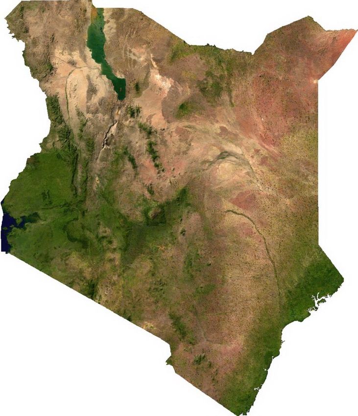
3 AFFECTED ENVIRONMENT

This section describes the critical environment that may be adversely affected by the implementation of
the IRS program (pesticide application) if adequate and necessary mitigation and monitoring measures
are not put in place. The critical ecosystems or activities within Kenya include surface water bodies
(lakes, river, groundwater, marshlands and wetlands), air, soils, and economic and sustenance activities
including agriculture, apiculture, fisheries and organic farming that might be adversely affected by the use
of insecticides to non-target areas.

3.1     OVERVIEW OF COUNTRY
3.1.1 GEOGRAPHY
Kenya's territory lies on the equator and overlies the East African Rift covering a diverse and expansive
terrain that extends roughly from Lake Victoria to Lake Turkana and further south-east to the Indian
Ocean. It is bordered by Tanzania to the south, Uganda to the west, South Sudan to the north-west,
Ethiopia to the north and Somalia to the north-east. Kenya covers 581,309 km2 (224,445 sq. mi), and
had a population of approximately 46.1 million people in 2015 with an estimated population growth of
2.6% per year; thus, Kenya’s 2017 population is projected to be 48.5 million.9

3.1.2 DEMOGRAPHICS
Of the total population, children under age 5 account for 16% and children under age 15 account for
42%. Kenya has approximately 42 ethnic groups and has a predominantly agricultural economy with a
strong industrial base. Kenya is ranked 145 out of 188 countries on the 2015 United Nation’s Human
Development Index, which measures life expectancy, adult literacy, and per capita income.10 Life
expectancy in Kenya has seen an overall downward trend since the late 1980s but increased to an
estimated 62 years in 2013.11 The mortality rate in children under five years of age has declined by 55%
from 115 deaths per 1,000 live births in the 2003 Kenya Demographic and Health Survey (DHS) to 52
deaths per 1,000 observed in the 2014 DHS.12 13

3.2     ADMINISTRATIVE AND POLITICAL UNITS
Since 2013, Kenya has been divided into 47 counties as a result of the process of devolution as set forth
in the 2010 Constitution of Kenya. Each County is subdivided in sub-counties. Figure 3-1 presents a map
of the 47 counties of Kenya.

9 World Bank. See http://www.worldbank.org/en/country/kenya. Accessed 1 November 2016
10 United Nations Development Programme. Human Development Report 2015.
11 UNICEF. State of the World’s Children 2015,

    http://databank.worldbank.org/data/reports.aspx?source=2&country=KEN. Accessed 25 May 2015.
12 Central Bureau of Statistics (CBS) [Kenya], Ministry of Health (MOH) [Kenya], and ORC Macro. 2004. Kenya

   Demographic and Health Survey 2003. Calverton, Maryland: CBS, MOH, and ORC Macro.
13 Kenya National Bureau of Statistics (KNBS), Ministry of Health (MOH) [Kenya], and ICF International. 2015.

   Kenya Demographic and Health Survey Key Indicators 2014. Nairobi, Kenya: KNBS, MOH, and ICF
   International.

                                                                                                           10
FIGURE 3-1: KENYA ADMINISTRATIVE UNITS
Mandera
Turkana
Marsabit
Wajir
West Pokot
Samburu
Trans Nzoia
Elgeyo-Marakwet Isiolo
Bungoma Baringo
Uasin Gishu
Busia Laikipia
Kakamega
Meru
Vihiga Nandi
Siaya
Kisumu Tharaka-Nithi
Kericho Nyandarua
Nyeri Garissa
Homa Bay Nyamira Nakuru
KirinyagaEmbu
Bomet
Kisii Murang'a
Migori Kiambu
Narok Nairobi Machakos
Kitui
Tana River
Makueni
Lamu
Kajiado
Kilifi
Source: Global Administrative Areas (http://www.gadm.org/country)
Taita Taveta
Mombasa
11
Kwale MombasaEach county has a county government that administers the affairs of the county. Individuals responsible
for malaria control at the county level sit in the County Ministry of Health offices.
3.3 PHYSICAL ENVIRONMENT
3.3.1 CLIMATE
Kenya’s climate varies by location from mostly cool every day, to always warm/hot. Along the coast, the
climate is tropical, which means that rainfall and temperatures are higher throughout the year. Ambient
temperatures change from cool to hot, almost every day in coastal cities like Mombasa, Lamu, and
Malindi. The climate further inside Kenya is more arid. This climate is nearly devoid of rainfall, and
temperature swings widely according to the general time of the day or night. This results in wide swings
in the daytime temperature of about 12°C (22°F), almost every day.14
There are two dominant influences on the climate in Kenya: the onshore monsoon winds from the
Indian Ocean, and altitude. The winds determine the onset of Kenya’s two rainy seasons, with the hot
northeast monsoon, kaskazi, blowing dry air in from the Persian Gulf from November to March/April
and the warm, moist monsoon, kusi, blowing in from the southeast from April/May to October. It is the
slightly cooler kusi that normally delivers the heaviest rain, a season known as the ‘long rains’, in late-
April, May and early June. The relatively cool season, from late-June to October, gets much less rain.
There’s a second rainy season, the ‘short rains’, for a few weeks in November and December, followed
roughly from mid-December to March by a dry season of hot, usually rainless, weather.15
Elevation is the other major factor in temperature levels, with the higher areas, on average, 11°C (20°F)
cooler, day or night. The many mile-high cities have temperature swings from roughly 10.0°C to 26.1°C
(50°F to 79°F). Nairobi, at 1,798 m (5,899 ft.), experiences temperatures within the range of 9.4°C and
26.7°C (49°F and 80°F). Similarly, Kitale, at 1,825 m (5,988 ft.), temperatures are between 51°F and 82°F
(10.6°C and 27.8°C).
At lower altitudes, the higher temperatures drastically differ: starting the morning at temperatures
higher than the highland daytime high, and the overnight low temperatures near sea level are nearly the
same as the high temperatures of the elevated highlands. However, lower altitude locations such as
Mombasa along the Indian Ocean have more moderate temperatures: a few degrees cooler in the
daytime.
There are slight seasonal variations in temperature of about 4°C (7.2°F) cooler during the winter
months. Although Kenya is centered at the equator, it shares the seasons of the southern hemisphere:
with the warmest summer months in December–March and the coolest winter months in June–August.
On the high mountains, such as Mount Kenya and Mount Elgon, the weather can become bitterly cold
for most of the year. Some snowfall does occur on the highest mountains.
The counties around Lake Victoria, which will be the initial focus of IRS activities, have a tropical humid
climate. Kisumu County altitude rises from 1,100 m along the Kano Plain to 1,800 m above sea level in
the Nyabondo Plateau. Migori County altitude ranges from 1,145 m to 1,800 m above sea level. The
county has an inland equatorial climate, modified by the effects of altitude and nearness to Lake Victoria,
both of which make the observed temperatures lower than is typical in equatorial climates. The recent
climatic trends in Homa Bay are a combination of rising temperatures and variable rainfall. Temperature
varies with altitude and proximity to the lake, and tends to increase towards the lowland with an
14 See http://www.climate-charts.com/Locations/k/KN63741.php, http://www.climate
charts.com/Locations/k/KN63661.php, and http://www.climate-charts.com/Locations/k/KN63820.php.
15 See https://www.expertafrica.com/kenya/info/kenya-weather-and-climate
12average of 17°C to 34°C. Temperatures are highest between December and March, with the hottest weather in February and the coolest in April and November. 3.3.2 RAINFALL PATTERNS Kenya experiences two rainy seasons (bimodal), namely the long-rains (March to May) and the short rains (October to December) seasons as the Inter Tropical Convergence Zone (ITCZ) migrates through the equator from south to north, and vice versa lagging the overhead sun by about 3 to 4 weeks. However, some areas in the western and central parts of the Rift Valley experience tri-modal rainfall pattern. The western parts of the country do realize significant rainfall during the period June to August associated with influences from the tropical south Atlantic and incursions of the moist Congo air mass when the meridional branch of ITCZ has maximum eastward displacement over the region. The coastal region of Kenya is also wet during this period. The January to February period is generally dry over most parts of the country. For the areas of recent IRS operation, the mean annual precipitation for Kisumu County is between 600 and 1,630 mm. The rains are bimodal and exhibit wide variation in distribution. Rainfall in Migori County is less than in a tropical equatorial climate, as it is caused by the convergence of the westerlies and southeast winds, which causes intense downpours in the afternoons. There are regional differences in rainfall in Homa Bay due to local air circulation: annual averages range between 700 and 1,800 mm, with first and second rains amounting to 250 mm to 1,000 mm and 50 mm to 700 mm respectively. The pattern of rainfall is generally bimodal, but the tendency for a trimodal regime can be observed around August and September. Evapo-transpiration is about 2,000-2,200 mm per year, which is high due to local winds. Figure 3-2 presents the distribution of average annual rainfall in Kenya. 13
FIGURE 3-2: KENYA ANNUAL AVERAGE PRECIPITATION

                   173 – 434 mm
                   434 – 651 mm
                   651 – 945 mm
                   945 – 1,383 mm
                   1,383 – 2,625 mm

               Source: Global Administrative Areas (http://www.gadm.org/country), World Resource Institute
                                 (http://www.wri.org/resources/data-sets/kenya-gis-data)

3.3.3 TOPOGRAPHY, GEOLOGY AND SOILS
Kenya is notable for its topographical variety. The low-lying, fertile coastal region, fringed with coral
reefs and islands, is backed by a gradually rising coastal plain, a dry region covered with savanna and
thorn bush. At an altitude of over 1,500 m (5,000 ft.) and about 480 km (300 mi) inland, the plain gives
way in the southwest to a high plateau, rising in parts to more than 3,050 m (10,000 ft.), on which most
of the population and the majority of economic activities are concentrated. The northern section of
Kenya, forming three-fifths of the whole territory, is arid and of semi-desert character, as is the bulk of
the southeastern quarter.16
Mt. Kenya (5,199 m/17,057 ft.) – Kenya's highest mountain, Mt. Elgon (4,310 m/14,140 ft.), and the
Aberdare Range (rising above 3,962 m/13,000 ft.) lie in the high plateau area known as the Kenya
Highland. The plateau is bisected from north to south by the Great Rift Valley, part of the geological
fracture that can be traced from Syria through the Red Sea and East Africa to Mozambique. In the north
of Kenya, the valley is broad and shallow, embracing Lake Rudolf (Lake Turkana), which is about 207 km
(155 mi) long; farther south the valley narrows and deepens and is walled by escarpments 600–900 m
(2,000–3,000 ft.) high. West of the Great Rift Valley, the plateau descends to the plains that border Lake
Victoria. Despite the location of Mount Kenya astride the Equator, it is perennially snow-capped. Other

16   See Nations Encyclopedia (http://www.nationsencyclopedia.com/Africa/Kenya-TOPOGRAPHY.html)

                                                                                                             14
isolated hills and mountains include Mount Kulal, Mount Nyiru and Mount Marsabit in the north of the
country, and the Taita and Chyulu Hills in the south. The latter is one of the region's most recent
volcanic formations. Figure 3-3 presents a satellite view of the topography of Kenya.
FIGURE 3-3: KENYA LANDCOVER
Source: Public Domain, https://commons.wikimedia.org/w/index.php?curid=946626
The geology of Kenya may generally be categorized into the following five major geological successions:
Archean (Nyanzian and Kavirondian); Proterozoic (Mozambique Belt and Bukoban); Palaeozoic/Mesozoic
sediments; Tertiary/Quaternary volcanics and sediments; and Pleistocene to recent soils, alluvial beach
sands, evaporites, fossil coral reefs and sandstones at the beach – these are alluvial and lacustrine
sediments of the Rift Valley. Also to be found are volcanic rocks of the Rift Valley from younger
volcanoes (Opiyo-Akech, Omuombo, and Masibo, 2013).
15In the Lake Victoria basin, lava deposits have produced fertile and sandy loam soils in the plateaus north
and south of Winam Bay, while the volcanic pile of Mount Elgon produces highly fertile volcanic soils
well known for coffee and tea production. The Rift Valley and associated highlands are composed of
fertile dark brown loams developed on younger volcanic deposits.17
However, the most widespread soils in Kenya are the sandy soils of the semiarid regions between the
coast and the Rift highlands. To the north of the Rift are vast areas covered by red desert soils, mainly
sandy loams. Kenya’s soils are subject to widespread erosion largely because of the lack of forest cover;
overgrazing and cultivation, especially in the arid and semiarid regions, also contribute to soil loss.13
3.3.4 BIOLOGICAL ENVIRONMENT
3.3.4.1 THE VEGETATION
Kenya contains diverse plant life. Along the Indian Ocean coast are forests containing palm, mangrove,
teak, and sandalwood trees. Baobab, euphorbia, and acacia trees dot the lowland plateaus, while
extensive tracts of savanna (grassland), interspersed with groves of acacia and some temperate forests,
characterize the terrain of the highlands up to about 3,000 m (about 9,000 ft). The higher alpine zone
contains giant senecio and lobelia shrubs.18
In the highlands between elevations of 2,100 and 2,700 meters (7,000 and 9,000 ft.), the characteristic
landscape consists of patches of evergreen forest separated by wide expanses of short grass. Where the
forest has survived human encroachment, it includes economically valuable trees such as cedar (Juniperus
procera) and varieties of podo. Above the forest, a zone of bamboo extends to about 3,000 meters
(10,000 ft.), beyond which there is mountain moorland bearing tree heaths, tree groundsel (a foundation
timber of the genus Senecio), and giant lobelia (a widely distributed herbaceous plant). East and west of
the highlands, forests give way to low trees scattered through an even cover of short grass.
The Semi-desert regions below 900 meters (3,000 ft.) give rise to baobab trees. In the still drier areas of
the north, desert scrub occurs, exposing the bare ground. The vegetation of the coastal region is
basically savanna with patches of residual forests. While the northern coast still bears remnants of
forests, centuries of human occupation have virtually destroyed them in the south.19
3.3.4.2 WILDLIFE 20
Kenya is abundantly populated with a variety of wildlife populations that live mostly outside Kenya’s
numerous national parks and game reserves. Some of the wildlife populations are found in urban areas,
in close proximity to human settlements, creating instances of conflict between humans and animals. In
an effort to ameliorate the problem, a “parks beyond parks” program was introduced in the mid-1990s
by the Kenya Wildlife Service. The plan attempted to include local communities in the management and
distribution of income derived from wild animals in their communities, thus making people more
tolerant of the presence of the animal.
The type of vegetation in each region seems to be related to the differentiation and distribution of its
wildlife. The highland rainforests support a variety of large mammals, dominated by elephants and
rhinoceroses, with bushbuck, colobus monkeys, and, occasionally, galagos (bush babies) also found
within areas with this vegetation type. The bamboo zone contains varieties of duiker and some species
of birds. Predators of the highlands include lions, leopards, and wildcats.
17 See https://www.britannica.com/place/Kenya
18 See http://www.countriesquest.com/africa/kenya/land_and_resources/plant_and_animal_life.htm
19 See https://www.britannica.com/place/Kenya
20 Based on information from the 2016 Encyclopedia Britannica https://www.britannica.com/place/Kenya
16The grasslands between the forest zone and lower areas contain habitats for the most vibrant animal
populations. These include hartebeest, wildebeest (gnu), zebra, gazelle, waterbuck, impala, eland,
warthog, and buffalo, which are preyed on by lions, spotted hyenas, leopards, cheetahs, and wild dogs.
Birdlife is much richer within this region, with the lakes and rivers inhabited by swarms of fish and
occasionally by hippopotamuses and crocodiles. One of the world’s largest populations of lesser
flamingos can be found in Kenya’s Great Rift Valley at Lake Bogoria, a soda lake (which is characterized
by high salinity and alkalinity).
To the north and northeast of Kenya are the thorn bushes and thickets of the arid regions, which are
populated with elephants, rhinoceroses, lions, leopards, giraffes, gerenuk, impalas, dik-diks, suni antelope,
and buffalo. Hippopotamuses, crocodiles, and many varieties of fish are found in the large rivers, while
the coastal waters contain abundant marine life, including butterfly fish, angelfish, rock cod, barracuda,
and spiny lobsters.
3.3.5 MAJOR WATER BODIES 21
Kenya’s drainage pattern originated when a large oval dome of rock arose in the west-central part of the
country and created the Central Rift. This dome produced a primeval watershed from which rivers once
drained eastward to the Indian Ocean and westward to the Congo River system and the Atlantic Ocean.
Still following this ancient pattern are the Tana and Galana rivers, which rise in the eastern highlands and
flow roughly southeast to the Indian Ocean. West of the Central Rift, however, the major streams now
drain into Lake Victoria. These include the Nzoia, Yala, Mara, and Nyando rivers. Between the eastern
and western systems, the rifting of the dome’s crust has created a complex pattern of internal streams
that feed the major lakes.
There are no major groundwater basins, and, apart from the Tana River, most of the rivers in Kenya are
short and often disappear during the dry season. Lake Victoria, with a surface area of 69,484 sq. km
(26,828 sq. mi), is the largest lake in Africa, the second largest freshwater body in the world, and a
major reservoir of the Nile River. Lake Turkana, some 150 miles (240 km) long and 20 miles (30 km)
wide, is the largest of the country’s Rift Valley lakes. Other lakes in Kenya are rather small, and their
surface areas fluctuate considerably. Figure 3-4 presents the surface water sources in Kenya, highlighting
some of the major lake and rivers.
21 Information for this section is primarily taken from the 2016 Encyclopedia Britannica
https://www.britannica.com/place/Kenya
17FIGURE 3-4: KENYA WATERBODIES
Lake Turkana
Nzoia River
River Yala
Lake Victoria
River Mara
Non-perennial/Intermittent/Fluctuating
Perennial/Permanent
Wetlands (seasonal and permanents)
Flood prone zones
Source: Global Administrative Areas (http://www.gadm.org/country), World Resource Institute (http://www.wri.org/resources/data-sets/kenya-gis-data)
183.4 PROTECTED AREAS
Protected areas in Kenya are mainly comprised of water bodies (e.g., lakes, rivers, wetlands, and
streams), National Reserves, National Parks, and Forest reserves. The protected areas in Kenya include
23 terrestrial National Parks, 28 terrestrial National Reserves, 4 marine National Parks, 6 marine
National Reserves, and 4 national sanctuaries. Some of these protected areas have been identified as
Ramsar sites. Figure 3-5 presents the protected areas in Kenya.
FIGURE 3-5: PROTECTED AREAS IN KENYA
Source: Global Administrative Areas (http://www.gadm.org/country), World Resource Institute
(http://www.wri.org/resources/data-sets/kenya-gis-data), and RSIS https://rsis.ramsar.org/ris-
search/?f[0]=regionCountry_en_ss%3AKenya
193.4.1 RAMSAR SITES 22
Kenya has 6 sites designated as Wetlands of International Importance (Ramsar) that cover an area of
265,449 hectares. These are located at Lake Baringo, Lake Bogoria, Lake Nakuru, Lake Naivasha, Lake
Elmenteita, and the Tana River Delta.
Lake Baringo
Lake Baringo is located in Baringo County at 00°32'N 036°05’E and covers 31,469 hectares. This
National Reserve consists of one of the two important freshwater (less-alkaline) lakes in the primarily
arid Kenyan Rift Valley and its surrounding riparian zones; the central island, Ol Kokwe, embodies the
remains of a small volcano. It is part of the Great Rift Valley system of faults and cliffs and is fed by
several freshwater inflows from the Mau and Tugen hills. The lake provides critical habitat and refuge for
nearly 500 bird species, and some of the migratory water bird species are of regional and global
conservation significance, with more than 20,000 individuals reported. The lake is an invaluable habitat
for seven freshwater fish species, of which one (the tilapia Oreochromis niloticus baringoensis) is endemic
to the lake. Local fisheries are particularly important for sustainable development of the local
communities, for both economic and sport fishing. In addition, the site is a habitat for many species of
animals, such as hippopotamus, crocodile and a wide range of mammals, amphibians, reptiles and
invertebrate communities. Four ethnic communities around the lake depend upon it for food, through
fishing, and for water supply, and a diversity of traditional religious functions are served by the lake and
surrounding escarpments. Long term overgrazing and deforestation and diversion for irrigation of water
from one of the inflowing rivers are seen as potential pressures, as are alien invasive species, such as
Pistia (Nile cabbage), and the use of motor boats for water sports.
Lake Bogoria
The lake is located at 00°15’N 036°05’E and measures 10,700 hectares. It is a National Reserve also
located in Baringo County. An alkaline soda lake hydrologically dominated by hot springs, located in
Gregory Eastern Rift Valley, the site provides critical refuge for the lesser flamingo (Phoenicopterus
minor), with a population of 1 to 1.5 million, and has high biodiversity values for more than 300 water
bird species. The shoreline fringe and associated acacia woodland provide critical habitat for the
endangered Greater Kudu and other mammals. The lake’s stable water level makes it doubly important
during periods of drought which reduce levels in other East African lakes. The regional climate is arid to
semi-arid with low rainfall reliability. Tugen and Jemps pastoralists live in the area, and livestock grazing
is the main land use at the site, but tourism, with attraction such as the wildlife, hot springs, spectacular
cliffs and escarpments, and the rich indigenous culture, brings 200,000 visitors annually; in addition, the
geysers are thought by some to have medicinal value.
Lake Nakuru
Lake Nakuru is within the Lake Nakuru National Park in Nakuru County, located at 00º22'S 036º05'E. It
measures 18,800 ha and is a very shallow, strongly alkaline lake, with surrounding woodland and
grassland set in a picturesque landscape. It is fed by four seasonal rivers and the permanent Ngosur
River, and represents one of the highest producers of biomass among Kenya's southern Rift Valley
alkaline lakes. A number of ecosystems including sedge marshes, seasonally flooded and dry grasslands,
swampland riparian forests, and various types of scrubland support some globally endangered mammal
species such as the black rhino and the hippo, as well as regionally endangered bird species like the
African Darter (Anhinga rufa), Great Egret, the range-restricted Grey-crested Helmet-shrike, the Lesser
kestrel and the Madagascar pond heron. The lake supports on average 24% of the Lesser Flamingo and
22 This section is based on information available from the Ramsar Sites Information Service (RSIS)
https://rsis.ramsar.org/ris-search/?f[0]=regionCountry_en_ss%3AKenya Accessed October 26, 2016
20You can also read