The relationship between transport accessibility and employment duration - WIDER Working Paper 2020/56 - unu-wider
←
→
Page content transcription
If your browser does not render page correctly, please read the page content below
WIDER Working Paper 2020/56

The relationship between transport accessibility
and employment duration

Jacomien van der Merwe1 and Stephan Krygsman2

May 2020

Abstract: The purpose of this research is to investigate whether transport accessibility influences
the employment duration of individuals in South Africa. The South African Revenue Service’s
IRP5 administration datasets, which indicate employment duration and spatial location data (where
workers reside and work) for all income earners in South Africa, were used to determine
individuals’ employment duration, as well as the travel distances between their residence and place
of employment. Airline distance was used as a proxy for transport accessibility. The results indicate
a negative relationship between increased commuting distance and employment duration for
lower-income individuals, with these commuters being more affected by greater travel distances
than higher-income groups. Spatial mapping indicates a job–housing mismatch in South African
metropolitan areas and limited employment search areas for lower-income workers compared with
higher-income workers, leading to further inequality.
Keywords: employment duration, equality, job–housing mismatch, transport accessibility
JEL classification: J64, R12, R40
Acknowledgements: This working paper is part of Work Stream 4, ‘Turning the tide on
inequality’, within the project ‘Southern Africa – Towards Inclusive Economic Development’ (SA-
TIED), and is supported by SA-TIED. The authors would like to acknowledge helpful comments
by participants at the SA-TIED workshop held in Pretoria in November 2019.
The authors greatly appreciate the guidance of Professor Hannelie Nel on statistical analysis, as
well as the assistance and input from Professor Tom de Jong on the calculation of airline distances
and the use of Flowmap.

1 Stellenbosch University, Stellenbosch, South Africa, corresponding author: jacomienvdm@sun.ac.za; 2 Stellenbosch University,

Stellenbosch, South Africa, skrygsman@sun.ac.za
This study is published within the UNU-WIDER project Southern Africa – Towards Inclusive Economic Development (SA-
TIED).
Copyright © UNU-WIDER 2020
Information and requests: publications@wider.unu.edu
ISSN 1798-7237 ISBN 978-92-9256-813-9
https://doi.org/10.35188/UNU-WIDER/2020/813-9
Typescript prepared by Luke Finley.
The United Nations University World Institute for Development Economics Research provides economic analysis and policy
advice with the aim of promoting sustainable and equitable development. The Institute began operations in 1985 in Helsinki,
Finland, as the first research and training centre of the United Nations University. Today it is a unique blend of think tank, research
institute, and UN agency—providing a range of services from policy advice to governments as well as freely available original
research.
The Institute is funded through income from an endowment fund with additional contributions to its work programme from
Finland, Sweden, and the United Kingdom as well as earmarked contributions for specific projects from a variety of donors.
Katajanokanlaituri 6 B, 00160 Helsinki, Finland
The views expressed in this paper are those of the author(s), and do not necessarily reflect the views of the Institute or the United
Nations University, nor the programme/project donors.
1 Introduction

Transport is associated with a negative utility. It represents friction between where people are and
where they want to be. This friction is often measured in terms of travel costs and travel time, and
possibly convenience, comfort, and safety of travel. Individuals will always attempt to minimize
this disutility while attempting to maximize access to employment, social facilities, education, etc.
Several researchers have explored this relationship between access and employment status,
income, and increased productivity. Labour force participation decisions are often based on
comparing the costs of working, which include transport costs, against the wages earned from a
job (Venables 2016). Any improvement in transport that lowers the generalized costs of transport
(time, money, and convenience) may therefore increase labour participation and support economic
growth. This is often one of the main arguments in support of transport infrastructure investment
policies.

South Africa faces significant employment challenges, as reflected by recent employment statistics.
Official unemployment has reached 30 per cent, although this figure may drastically underestimate
unemployment among the youth and low-schooled populations. There was a 31 per cent increase
in the number of discouraged workers 1 in South Africa between the first quarter of 2017 and the
same quarter in 2019 (Stats SA 2017b, 2019a).

The National Household Travel Survey (NHTS) of 2013 revealed that 75 per cent of households
that earn up to ZAR3,000 per month spend 20 per cent or more of their income on transport to
commute to work (Stats SA 2017a). This is more than double the national benchmark of limiting
transport expenditure to 10 per cent (Department of Transport 2015). This survey also indicated
disproportionate expenditure on transport between low- and high-income households. High-
income households spend 10 per cent or less of their household income on transport. This
contributes to the income inequality in South Africa and may contribute to the high unemployment
rates of lower-income groups in the country. The most recent Quarterly Labour Force Survey
(QLFS), in the fourth quarter of 2019, reveals that the biggest reasons why people are not looking
for work are that 69 per cent indicate that no jobs are available in their area, secondly 6 per cent
indicated losing hope of finding a job, and thirdly 4 per cent indicate that they lack money to pay
for transport to look for work (Stats SA 2019c).

South African cities are characterized by an unbalanced spatial structure, with lower-income and
often vulnerable communities located on the periphery, far away from employment opportunities
and other amenities (Sinclair-Smith and Turok 2012). The result is long travel times, and potential
high transport costs to access employment and other activity engagement opportunities. This may
lead to lower levels of employment and shorter employment duration for these income groups.

Investment in transport and improved accessibility can lead to direct economic benefits, such as
lower transport costs and better time utilization. Improved accessibility can also lead to indirect or
third-order benefits that create economic development through higher rates of employment,
technological innovation, spatial agglomeration, 2 and increased productivity. Employment can be
further unpacked by investigating the benefit of increased employment duration or lower employee

1
 Discouraged jobseekers are unemployed individuals who want to work, but feel discouraged from actively find work.
2
 Spatial agglomeration is the spatial clustering of industries, firms, or labour.
 1
churn, which increases employer productivity, decreases recruitment costs, and increases employee
morale.

This paper aims to establish whether transport accessibility, measured by spatial separation, has an
impact on the employment duration of workers, specifically for individuals in lower-income
groups.

2 Literature review

2.1 Spatial and modal mismatch

Kain (1968) investigated housing market discrimination towards African American workers in the
USA and the impact thereof on unemployment. This research led to the spatial mismatch
hypothesis, which states that low-income households that live far from employment opportunities
will experience higher rates of unemployment. Later studies built on Kain’s spatial hypothesis and
highlighted that poor access to proper public transport modes, in addition to travel distance, could
also have a major impact on job accessibility. This is specifically true for captive-mode 3 low-income
commuters with no access to private transport (Grengs 2010).

Kain’s hypothesis was investigated in the South African context by Rospabe and Selod (2006).
They studied the spatial segregation of where people live and work in the City of Cape Town using
the Regional Services Councils’ (RSC) levy database 4 and the Migration and Settlement in the Cape
Metropolitan Area 1998 dataset. 5 They investigated the impact of spatial mismatch (between home
and work location) on unemployment. A logistic regression model estimated the probability of an
individual being unemployed considering various individual, household, and neighbourhood
characteristics. Average commuting distance was included as an independent variable, and the
researchers found that an increase in commuting distance will increase an individual’s probability
of being unemployed.

Blumenberg and Pierce (2014) used a panel dataset comprising data collected in five major
metropolitan areas in the USA 6 to estimate the relationship between automobile ownership and
transit access, with employment retention as the dependent variable. They also used a multinomial
logistic regression model and found that households which gained access to a private vehicle to
commute to work increased their probability of finding employment by a factor of two. Their
research also indicated an increase in employment when households moved to a neighbourhood
with better public transport access.

A study conducted in the UK by Johnson et al. (2017) explored the relationship between transport
accessibility (public transport travel times) and employment using cross-sectional data. Their
research attempted to control the potential causal relationship between transport accessibility,

3
 Captive-mode users do not possess a driver’s licence or do not own a car and thus have no other choice than to use
either non-motorized transport or public transport.
4
 The RSC levy is a tax on firms that operate in the City of Cape Town and was used to create an administrative
database of such firms.
5
 The sociology department of Stellenbosch University and the Cape Metropolitan Council undertook this survey in
1998 to support spatial development in the Cape Metropolitan Area.
6
 Baltimore, Boston, Chicago, Los Angeles, and New York.
 2

vehicle ownership, and employment by using an instrumental variable approach. Elasticity was
calculated, which indicated that a reduction in public transport travel time of 10 per cent would
increase employment by between 0.13 and 0.3 per cent. 7

Lau Cho-Yam (2010) elaborated on the history of spatial planning in Hong Kong and painted a
very similar picture to the one in South Africa: the segregation of poor residents in neighbourhoods
far from job opportunities, a movement from a manufacturing- to a service-driven economy, a
shrinking job pool for lower-skilled individuals, and high income inequality. Lau Cho-Yam’s (2010)
study attempted to identify the relationship between urban decline, transport provision, and job-
seeking range. It used the space-time activity approach to determine the size of the daily potential
path area for each household as a proxy for access to potential job opportunities. Past and current
spatial planning has led to an increasing income gap between the working poor and the high-
income population. As a recommendation, the study stressed the fact that potential social impacts
should be included in cost–benefit appraisals to improve transport access and increase the job-
seeking range of low-income residents.

2.2 Transport accessibility and job search

Phillips (2014) conducted a study in the USA proving that unemployed individuals who receive a
direct transport subsidy, which reduces their transport costs when searching for work, significantly
increase their job search intensity, ultimately leading to shorter periods of unemployment.
Research by Franklin (2015) supported this relationship between transport costs and job-seeking
efforts by conducting a controlled group survey in Ethiopia. He provided transport subsidies to
individuals who searched for work, and found that more people searched for work when they
received a transport subsidy compared with the group that did not receive a subsidy.

The increase in discouraged work seekers in South Africa has fuelled the discussion on whether
transport costs have an impact on job search intensity. Some calls have been made to compensate
unemployed work seekers for their transport costs in order to reduce their search costs.

Data from the South African National Income Dynamics Survey (NIDS) were used by Ngarachu
et al. (2015) to investigate the relationship between wages and transport costs. The research
concluded that transport costs are a significant driver of inequality in South Africa and that lower-
income workers find it difficult to ‘transfer’ the cost of commuting to their employer and to
allocate a significant percentage of their salaries to transport compared with higher-earning
individuals.

The impact of transport affordability on equality in South Africa was confirmed in a study
conducted by Kerr (2015). He compared the commuting times for commuters of different income
groups using different transport modes. The study indicated that commuters who make use of
public transport—specifically bus and minibus taxi—spent a significantly higher percentage of
their income on transport than private vehicle users. He also compared different datasets, such as
the NIDS, NHTS, and the Project for Statistics on Living Standards and Development (PSLSD) 8
to show the ever-increasing travel times for commuters in South Africa and the significant
difference in travel times from commuters of other countries. Kerr (2015) emphasized the

7
 0.13 per cent for rural areas and 0.3 per cent for more dense urban areas.
8
 Conducted by the Southern Africa Labour and Development Research Unit, SALDRU, at University of Cape Town.
 3
importance of government spending on public transport to reduce the cost of commuting and to
reduce the travel times for public transport users to benefit low-income residents.

Kgwedi and Krygsman (2019) illustrated not only that low-income workers in South Africa face
long transport travel times, but that these commutes involve significant transfers, as well as access
to and egress from the public transport system. The out-of-vehicle time component often exceeds
the time spent on the public transport mode, which results in onerous commutes (Kgwedi and
Krygsman 2019).

2.3 Employee churn

Kerr (2017) defined churning as the difference between worker flows and job flows, 9 and found
that workers change jobs much more relative to job openings at firms, which gives rise to increased
churning. If worker flows exceed job flows, this indicates employee churn. Higher employee churn
is associated with higher recruitment and training costs, as well as lower productivity among
workers. Studies conducted to calculate worker flow and churn in companies use different datasets,
including household censuses (Bassanini and Garnero 2012) and quarterly employment surveys
that collect data on how firms in South Africa create or terminate jobs (Kerr et al. 2013), as well
as a newly available dataset from the South African Revenue Service (SARS). 10 These records
indicate how workers move in and out of employment at firm level from one tax year to the next
(Kerr 2017), and that more workers move in and out of employment as needed by firms to adjust
to their company size.

Churning in South African firms equalled an average of 30.78 per cent, indicating that almost one-
third of employees move between employment or out of employment per year (Kerr 2017). Kerr
(2017) also suggested that employee churn is not industry-specific, but that churn rates are firm-
specific and that human resource policies adopted by firms could be the main driver of higher
churn rates.

This literature review indicates the current limited understanding of the relationship between
transport accessibility and employment duration, with limited disaggregate data and spatial
information that has hindered past research attempts.

3 Limitations to existing South African transport and employment data

The only source of travel data at household level for South Africa is the 2013 NHTS (Stats SA).
A total of 51,341 dwelling units (households) were interviewed, resulting in travel information
obtained from 157,273 individuals. The employment-related questions included employment
status, location data at the enumerator area (EA) level of where the person resided, 11 location data
on the transport zone level of where the person was travelling to, gross income, and trip details,
which included the following:

9
 Worker flows are defined by Kerr (2017) as the sum of all hires and separations in a firm in a tax year. Job flows are
defined as the difference between employment in a tax year and employment in the previous tax year.
10
 The SARS datasets include data on workers who earn more than ZAR2,000 per annum in South Africa.
11
 An EA is the smallest geographical unit (piece of land) into which a country is divided for enumeration purposes.
EAs contain between 100 and 250 households.
 4

• trip start and end time (used to calculate travel time between origin and destination);
 • mode(s) used;
 • trip costs;
 • whether the individual received an employer travel subsidization.

The sample of 157,273 individuals who were interviewed consisted of children, workers, non-
workers, and people of 65 and older. Only 22,593 individuals who commuted to (either informal
or formal) work provided origin and destination locations. While the NHTS survey data is useful
to analyse general transport trends and general levels of access, it is less suitable to model
accessibility and is not able to determine employee churn or duration.

As the travel time information in the NHTS is stated and not actual measured travel time, it may
also not accurately reflect actual accessibility.

3.1 National Income Dynamic Survey (NIDS)

The NIDS 12 interviewed approximately 30,000 individuals from 7,000 households in South Africa
in five waves over a nine-year period from 2008 to 2017. One of the purposes of the survey was
to track changes in individual and household income and expenditure and individual employment
status.

The NIDS is useful for tracking changes in individuals’ employment status and to establish
whether there are income and expenditure or household characteristics that may influence the
employment duration of individuals. Unfortunately, only Wave 2 of the survey included travel-
related questions as part of the employment section. Information on the location where the
individual worked was excluded. Other travel information collected included mode of transport,
trip costs, travel distance, and travel time. While it is possible to investigate the relationship
between employment duration and transport accessibility using Wave 2 of the NIDS, the sample
size is not ideal.

Recently, a unique opportunity arose to use the SARS datasets to establish whether such a
relationship exists, which may allow for a more in-depth examination of this relationship.

4 Data sources

The data for this paper are from the SARS datasets, which were made available through
collaboration between UNU-WIDER, National Treasury South Africa, and SARS. This was
supplemented with the spatial data layers of the 2013 NHTS and 2011 Census, which were used
to develop distance matrices that were merged with the SARS datasets.

4.1 Distance and travel time matrices

ArcMap, together with Flowmap, 13 which is a software package used to visualize and analyse
geographical and flow data, was used to develop an origin-destination (O-D) matrix to measure
airline distance (in kilometres) between all main places in South Africa. Origins and destinations

12 The NIDS user manual can be downloaded from the DataFirst website (see Brophy et al. 2018).
13
 http://flowmap.geo.uu.nl.
 5
are represented by the centroids of each main place. This dataset consists of 197,093,521 O-D pair
observations.

‘Internal trips’ refers to instances where the workplace and residence fall in the same main place.
Three equations (see Table 1) were used to generate three internal trip distance measurements.
The three equations differ with regard to (1) how the residences and workplaces are distributed
within the main place polygon, (2) the form of the main place polygon, and (3) the perimeter and
assumed average speed of the modes used for travelling. An area-based approach was used
whereby the internal trip distance was derived from the size of the main place.

Research conducted by Melhorado et al. (2016) provides a more detailed analysis of the different
methodologies for calculating internal trips. These three methods of calculating internal trip
distances were chosen due to data availability.
Table 1: Equations to calculate internal trip distances

Internal trip distance Equation
Internal trip distance method 1

 0.91 ∗ �

Internal trip distance method 2 2 ∗ √ / 3

 �
Internal trip distance method 3
 � �
 ⎛1 + ln( 2 ⎞∗ /
 � √2
 ⎝ ⎠

Notes: area and perimeter are the spatial properties of the main place and speed is a function of mode. The
speed is assumed at 20 km/h, which is the weighted average speed derived from the Cape Town Transport
Demand Model over all modes in the morning peak period.
Source: authors’ construction based on Melhorado et al. (2016).

The average internal distances and standard deviations by metropolitan area of the three methods
were compared with the same O-D distances recorded in the NHTS 2013. Method 2 was
considered the best fit and was thus used in this study. This equation assumes that employment
opportunities are more concentrated within the main places compared with the concentration of
households.

The airline distances, together with the internal trip calculations, were used as a proxy for
accessibility in this study.

4.2 South African Revenue Service (SARS) data

South African employers that are registered for pay-as-you-earn (PAYE 14) are required to provide
their employees, irrespective of the amount of remuneration, with an IRP5 certificate (employee
tax certificate). These certificates contain information about the employer, such as the company

14
 PAYE is a system where the employer deducts income tax from the employee’s salary and pays it directly to the
revenue service—SARS, in South Africa’s case.
 6
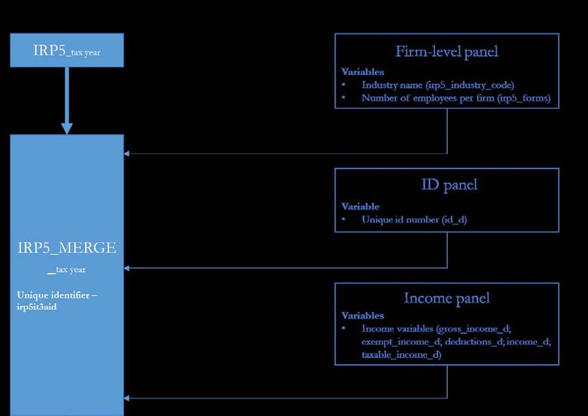
name, physical address, PAYE registration number, and their Skills Development Levy and
Unemployment Insurance Fund information.

Information regarding the employee includes their name, physical address (home), bank details,
period of employment, and income information such as total income, allowances, and fringe
benefits received for the tax year. It also reflects any deductions made regarding pension fund and
medical aid.

The IRP5 datasets for the period 2011–17 were made available to the researchers. These datasets
were already anonymized whereby no specific person or entity could be identified through the
data. Additional fields attached to the individual IRP5 certificates include gender, employee’s date
of birth, and a main place identifier. The main place identifiers do not indicate any home address.
The data were cleaned by us; this cleaning is described in detail below.

Two individual panel datasets, identification (ID) panel and income panel, were derived from the
IRP5 datasets for the period 2011–17. The ID panel links a unique ID number, representing a
person, to each IRP5 certificate over the period. This allows the identification of individuals over
multiple years. The income panel represents the aggregated income information for a specific
individual (by unique ID number) for each tax year. This dataset therefore provides the total
income of an individual, from multiple employers or from multiple IRP5 certificates from one
employer, for each tax year. 15

A firm-level panel dataset16 allows researchers to link the IRP5 data to specific company income
tax (CIT) data such as the number of employees per firm and the firm industry. 17 The individual
panel datasets, as well as the firm-level panel dataset, were merged with the IRP5 datasets to
construct a combined IRP5 dataset (‘IRP5_Merge_201x’) with each variable linked to a unique
IRP5 number. This is illustrated in Figure 1.

15 Ebrahim and Axelson (2019) discussed the IRP5 and panel datasets in detail.
16
 This was created by merging (1) company income tax data, (2) the IRP5 data (individual income tax), 3) value-added
tax (VAT), and 4) customs records from traders. An introduction to these datasets was provided in Pieterse et al.
(2018).
17
 The VAT and customs data were not incorporated into the combined IRP5 dataset for this study.
 7

Figure 1: Process of merging SARS datasets

Source: authors’ construction.

Table 2 presents the main variables used in the research.
Table 2: Main variables in IRP5 datasets

Variable Example Description

Identifiers
id_d abcdek Derived variable from ID panel. Identifies unique individuals over the tax
 years. Referred to as ’employees’.
irp5it3aid 1285012967 Unique IRP5 ID number allocated by SARS after a return is submitted.
 Indication of the number of jobs per employer or firm.
PAYE_RefNo DJFKVMDL The PAYE reference number of the IRP5 certificate. Referred to as
 ’employers’.
taxrefno IEOLGMCS Anonymized unique SARS tax reference number. Variable linked to the
 firm-level panel.
taxyear 2017 Refers to the tax year from 1 March to the last day of February (i.e. the
 2017 tax year ran from 1 March 2016 to 28 February 2017).
Demographics
Age 33 Derived from the date-of-birth variable. Age of the employee in the
 specific tax year.
Gender M Derived from the individual’s South African ID number.
Nationality 1=ZA citizen, Derived variable indicating whether the employee is a South African
 0=Foreign citizen or not. Derived from whether an IRP5 observation is linked to an
 anonymized South African ID number or an anonymized passport
 number.
Employment
employment_start 2016/03/01 Start date of employment in the particular tax year.
employment_end 2017/02/28 End date of employment in the particular tax year.

 8
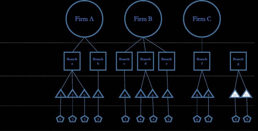
employment 365 Derived variable from employment_start and employment_end variables.
duration_days
irp5_empl3601 5 Number of IRP5 forms receiving an income 3601 code* per firm in tax
 year.
id_d_Branch 4 Number of employees (id_d’s) per employer (per PAYE reference
 number).
irp5_industry_code MINING AND Industry code derived from IRP5 form.
 QUARRYING
Gross_income_d 50293 From income panel. Sum of all income (business, normal, allowances,
 fringe benefits, lump sum income, etc.) for an individual in the specific tax
 year.
Nature_of_person INDIVIDUAL Only certificates on behalf of individuals were included. Other options
 represented in the IRP5 datasets included clubs, partnerships, retirement
 funds, and associations.
Location
province_geo Western Cape Province in which the employee resides. Derived from postal address
 code.
districtmunicip_geo City of Cape District municipality in which the employee resides. Derived from postal
 Town address code.
localmunicip_geo City of Cape Local municipality in which the employee resides. Derived from postal
 Town address code.
mainplace_geo Cape Metro Main place in which the employee resides. Derived from postal address
 code.
busprov_geo Western Cape Province in which the employer (PAYE_RefNo) operates. Derived from
 postal address code.
busdistmuni_geo City of Cape District municipality in which the employer (PAYE_RefNo) operates.
 Town Derived from postal address code.
buslocmuni_geo City of Cape Local municipality in which the employer (PAYE_RefNo) operates.
 Town Derived from postal address code.
busmainplc_geo Epping Industria Main place in which the employer (PAYE_RefNo) operates. Derived from
 postal address code.

Note: * a 3601 code is an income source code that represents basic income on the IRP5 form.
Source: authors’ construction.

The unique identifier, ‘id_d’, in Table 2 is explained in detail in Pieterse et al. (2018: page 10). CIT
information is available at the firm level and firms can have multiple branches. Take, for example,
the Shoprite Checkers Supermarket Group, which is represented as a firm but consists of several
different Shoprite and Checkers branches across the country. This study specifically examined
employment at ‘branch’ level, which is represented by the unique PAYE reference number, and
not at firm level, which represents companies in the CIT data. Branch-level data allowed travel
distances to be derived between the employer at the branch level (‘busmainplace_geo’) and the
employee’s place of residence (‘mainplace_geo’).

Pieterse et al. (2018) also explained the linkage between firms, branches, jobs, and employees, and
mentioned the different possible combinations in the SARS data. Figure 2 illustrates the different
combinations and terminology used in this research. The following should be noted:

 • There are branches and IRP5 forms that cannot be linked to firms (for example, Branch g),
 as some of the PAYE entities are linked to government institutions that do not pay CIT.
 • In the IRP5 datasets, duplicate ‘irp5it3aid’ variables were observed, which were also linked
 to the same employee (‘id_d’). These duplicate records were omitted in order not to
 overstate the number of jobs per branch (for example, ‘Branch a’ and ‘IRP5 2’).
 • An employee (‘id_d’) can be associated with more than one branch: for example, where a
 consultant works for multiple companies simultaneously or where an individual has

 9
worked for different employers for different periods of time in a specific tax year. This is
 represented as ‘id_d 1’ in Figure 2. An individual can also be linked to more than one IRP5
 at the same company where an individual has worked for different time periods at the
 same company (see ‘id_d 4’).
Figure 2: Illustration of the relationship between firms, branches, IRP5 forms, and employees

Source: authors’ construction.

The employment duration variable was derived from the ‘employment_start’ and
‘employment_end’ variables. These dates should not start before the first day of the tax year
(1 March) and should also not end later than the last day of the end of the tax year (28 February,
or 29 February in leap years). The procedure presented in Table 3 was followed for observations
that did not meet these criteria to derive the variable employment ‘duration_days’.
Table 3: Actions followed to derive employment duration variable

Variable Recorded date Action
‘employment_start’ Within one month before the first Replace ‘employment_start’ record with 1 March
 day of the tax year (1 March) (move the date forward to 1 March)
‘employment_start’ More than one month before the Omit the observation
 first day of the tax year
‘employment_end’ Within one month after the last Replace ‘employment_end’ record with
 day of the tax year 28/29 February (move the date back to 28 or
 (28/29 February) 29 February, depending on whether it is a leap
 year)
‘employment_end’ More than one month after the Omit the observation
 last day of the tax year
 (28/29 February)

Source: authors’ construction.

 10
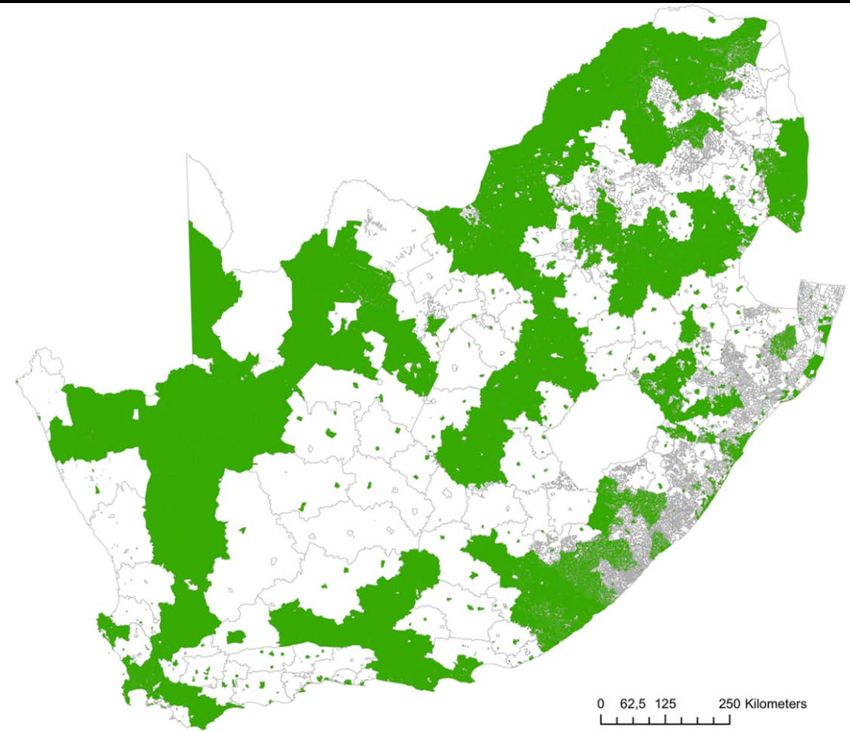
Limitations of the location variables

Limitations to the methodology of creating spatial data are discussed in Ebrahim and Axelson
(2019).

The spatial location of the main places where the employee resides (home) and where the employer
is located (workplace) was derived by obtaining the centroid of the postal code reflected on the
IRP5 form. By running the postal codes through the Google application programming interface
(API), the matching main place was identified (Ebrahim and Axelson 2019). This centroid was
then linked to a specific main place in which that centroid fell, and the main place was linked to
the more aggregated location fields such as the local and district municipality and province.

The limitations to this approach are as follows:

 • The Google API could have allocated an incorrect output of the postal code centroid.
 • The centroid, which is allocated by the Google API, may not accurately reflect the centroid
 of the postal code, which is easily distorted when working with non-circular polygons.
 • The postal code zone may overlap several main places, and the centroid of the postal code
 may not fall within the main place which covers the largest area of the postal code.
 • The address field of the employee is very poorly populated, as it is not compulsory to
 complete this field on the IRP5 form. The workplace addresses have been populated more
 consistently since 2013. Table 4 indicates the percentage of residential and workplace
 location information obtained for the specific tax year. In addition, it indicates the
 percentage of observations that have both origin and destination data available.

These limitations could lead to incorrect distance calculations due to attributing the wrong main
place centroid to an observation. However, these biases will occur less in metropolitan areas, where
postal codes are better geographically defined and main places smaller compared with rural areas.
Table 4: Percentage of observations in the IRP5 datasets with location data

Tax year Residential Workplace O-D pairs
2011 21 1.30 0.3
2012 34 5.20 1.8
2013 42 73 42
2014 32 90 31
2015 16 91 15
2016 16 90 16
2017 16 88 16

Source: authors’ construction based on from Ebrahim and Axelson (2019) and IRP5_Merge_201x datasets

The SARS IRP5 datasets from 2013 to 2017 were used for further analysis in this research as they
contained the highest sample of observations with O-D pairs as indicated in Table 4.

Figure 3 illustrates in green the main places where data exist on where workers reside and where
they work. Large parts of rural South Africa are not represented in the data, but there is good
representation of metropolitan areas. This figure also indicates the size of the main places, which
is the most disaggregated spatial unit for the location data in the SARS IRP5 datasets. The
coarseness of this zoning system may lead to inter-zonal travel patterns not being observed or
could lead to problems such as the modifiable areal unit problem (MAUP) whereby data are
totalled to a more aggregated spatial unit, which may influence the results of statistical hypothesis
testing (Openshaw 1983).
 11
Figure 3: Location data available by main place (2017 tax year)

Source: authors’ construction based on IRP5_Merge_2017 dataset.

Representativeness of the sample

Table 4 indicates the percentage of observations with O-D pairs that may result in the sample of
observations with O-D pairs being unrepresentative of the full sample. Table 5 indicates the
percentage and mean difference in the full sample compared with the O-D sample for different
variables across years. It can be seen that the variables ‘age’, ‘gender’, and ‘nationality’ are not
significantly different between the full sample and the O-D sample. The mean gross income
variable, however, indicates that the O-D sample is on average 10 per cent higher than the full
sample. This indicates that the O-D sample under-represents lower-income groups. This under-
representation should be kept in mind when interpreting the results.

 12
Table 5: Difference in sample statistics for the variables ‘age’, ‘income’, ‘gender’, and ‘nationality’

Variables 2017 2016 2015 2014 2013
 All O-Ds All O-Ds All O-Ds All O-Ds All O-Ds
Total 13,759 2,200 13,574 2,128 13,655 2,091 13,305 4,124 11,319 4,755
observations
(’000)
% observations 16 16 15 31 42
kept (with
O-Ds)
Age (mean) 37.4 36.8 37.3 36.7 37.2 36.8 37.1 38.2 36.5 37.1
Age (mean) −0.5 −0.6 −0.4 1.1 0.6
difference (in
years)
Gross income 204 231 179 209 196 196 179 198 135 161
(mean) (’000)
(ZAR)
Gross income 11 14 0 10 16
(mean) (%)
difference
Male (%) 0.53 0.56 0.53 0.56 0.54 0.57 0.54 0.51 0.57 0.56
Male 0.03 0.03 0.04 −0.03 -0.01
(proportion
difference)
Foreign (%) 0.03 0.04 0.03 0.04 0.03 0.03 0.03 0.02 0.03 0.03
Foreign 0.00 0.01 0.01 −0.01 0.00
(proportion
difference)

Source: authors’ construction based on IRP5_Merge_2017 dataset.

A process of data cleaning and transforming was followed to derive a cleaned O-D dataset for the
2013–7 tax years. The following tasks were undertaken on the datasets:

 • Where duplicate ‘irp5it3aid’ existed in the same branch (‘PAYE_Refno’) linked to the same
 employee (‘id_d’) in a tax year, all duplicates were omitted, with only one entry remaining.
 • All records were omitted if the IRP5 record indicated that the nature of the person
 (‘Nature_of_person’ variable) was other than ‘INDIVIDUAL’. This was done to exclude
 trusts, partnerships, etc. from the datasets.
 • If an individual was stated to be younger than 15 in the particular tax year (15 is the
 youngest age at which a person may legally be employed in South Africa), the observation
 was omitted. An observation was also omitted if a person was older than 75.
 • If the employment duration field of the observation was missing, the observation was
 omitted.
 • If an employee was linked to more than one ‘irp5it3aid’ record in the datasets for the same
 employer (‘PAYE_Refno’), only the record with the longest employment duration for that
 individual at the specific employer was retained and the other duplicate observations were
 omitted.
 • Observations with a gross annual income of zero or less (2.5 per cent of observations)
 were omitted.

A geographical classification was generated for each observation to indicate whether the employer
(workplace) is situated in a metropolitan area, urban area, or rural area. These classifications were
derived from the 2011 Census data classifications by EA. The following procedure was followed
to generate this variable:

 13
• If the municipal type (‘mn_type’ variable in Census 2011 data) was ‘Metro’, the main place
 that fell within that municipality was classified as ‘Metro’.
 • If an EA was classified as ‘Farms’ or ‘Traditional’ (the ‘EA_gtype’ variable in the Census
 2011 data), the EA was classified as ‘Rural’.
 • If an EA was classified as ‘Urban’ (the ‘EA_type’ variable in the Census 2011 data), the
 EA was classified as ‘Urban’.

A main place consists of many EAs, resulting in main places with different EA geographical
classifications. The total square kilometres for each classification according to ‘Metro’, Urban’, or
‘Rural’ was calculated by main place, and the classification that covered the highest percentage area
within the main place was selected.

Spatial mapping was conducted to investigate the employment and travel characteristics at
metropolitan level using ArcMAP. Descriptive statistics in the form of histogram plots and tables
were created to provide insights into the employment and travel characteristics of different income
groups, individuals commuting in different metropolitan areas, and different geographical
classifications.

Correlation analysis, pairwise mean comparisons, and regression analysis were conducted to
investigate the relationships between travel distance, transport proximity, and employment
duration. These analyses were conducted by excluding all trips of over 100 km to prevent long
distances such as trips between metropolitan areas from distorting the outcomes. The deciles for
airline distances from 2013 to 2017 were calculated to determine the most appropriate cut-off
point. The summarized statistics (see Table 6) indicate that at least 80 per cent of trips were shorter
than 100 km over the five-year period, with average distances varying between 110 km and 114 km.
This resulted in the decision to choose a 100 km cut-off over all five years.
Table 6: Airline distance deciles and mean airline distance between 2013 and 2017 tax years

Airline distance deciles 2017 2016 2015 2014 2013
10 3.037316 2.83303 2.846097 3.469148 2.983863
20 5.855942 5.854458 5.854458 6.863139 5.415972
30 8.242757 7.987182 8.38528 8.640365 8.13919
40 10.02028 10.02028 10.19311 12.19849 10.56262
50 13.33793 13.2504 13.33793 17.48068 16.15635
60 20.46617 19.63257 19.47487 27.99332 26.459
70 35.26675 33.96829 34.03584 50.7902 47.91126
80 74.72463 68.74125 68.74125 110.454 101.7226
90 372.1665 344.3791 344.7335 339.2555 336.4383
Mean distance 114 110 111 114 111

Source: authors’ construction based on IRP5_Merge_2017 dataset.

 14
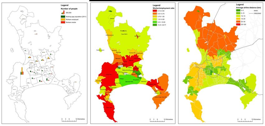
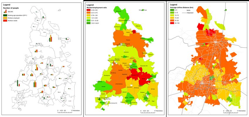
5 Data analysis

5.1 Job–housing balance

Figures 4 to 6 indicate the mismatch between where workers in South Africa reside and where
they are employed within the five main metropolitan areas 18 according to the IRP5_Merge_2017
dataset. They also indicate the working-class population 19 according to the 2011 Census by main
place. This mismatch is represented by a worker/employment ratio (see Table 7). 20 A ratio smaller
than 1 indicates higher numbers of employment opportunities than the number of workers
residing in the main place, resulting in an inflow of workers to that main place. A ratio larger than
1 indicates higher numbers of workers residing in the main place than the number of employment
opportunities, which indicates an outflow of workers from the main place. These figures also
indicate the average airline distance 21 for workers travelling to a specific main place.
Table 7: Worker/employment opportunity ratio by metropolitan

Metropolitan Worker/employment opportunity ratio Airline distance
 Mean Std. dev Min. Max. Mean (km)
City of Cape Town 4.01 7.330359 0.15 31 15
Gauteng region 6.2 6.203325 0.32 35 22
eThekwini 9.01 28.41567 0.28 188 10

Source: authors’ construction based on IRP5_Merge_2017 dataset.

The City of Cape Town shows a high inflow of workers to the main central business district (CBD),
City Bowl, with a relatively low number of workers who reside in the same main place. This
indicates that most workers must travel between 15 and 20 km to reach employment opportunities
in this main place. Figure 4 also indicates a surplus of workers who reside in the Metro South-East
(Philippi, Mitchells Plain, and Khayelitsha), with limited work opportunities in these predominately
low-income communities. Similar results were reported by Krygsman et al. (2016), which indicated
large employment surpluses in the city centre and residential surpluses in predominately low-
income residential areas.

eThekwini shows a better job–housing balance compared with the other two metropolitan areas.
Figure 5 indicates that most workers are employed in the Durban main place, which requires
commuters to travel between 15 and 20 km to reach their place of employment. The Gauteng
metropolitan area shows a large inflow of workers into the Johannesburg, Sandton, and Pretoria
CBDs, with a noticeably large outflow of workers from the Soweto main place. Figure 6 indicates
that people travel the longest distances in this metropolitan area compared with Cape Town and
eThekwini, where most workers travel between 20 and 30 km to their place of employment.

Travel time is a function of network distance, speed, and interconnectivity. As Kgwedi and
Krygsman (2019) indicated, travel using public transport, specifically rail and bus, involves

18
 The City of Cape Town, eThekwini, and Gauteng region, the latter representing the City of Johannesburg, the City
of Tshwane, and Ekurhuleni combined.
19
 All individuals between the ages of 15 and 65.
20
 Calculated by dividing the total number of workers who reside in that main place by the total number of workers
employed in that main place.
21It is important to note that Figures 4 to 6 (right-hand graphs) represent airline distance and not actual travel time
or distance.
 15
significant transfers and additional access and egress stages. Low-income communities may face
significantly longer travel times, as revealed by airline network distance.

These figures indicate the extent of the job–housing imbalance in South African cities and the
need to stimulate small and medium enterprises and other work opportunities in areas where
people reside in order to reduce the distances travelled by workers. Attention should also be paid
to increasing investment in public transport from the main places where a surplus of workers
reside to the main places where there is a surplus of work opportunities.

 16
Figure 4: City of Cape Town: Population and employment distribution and average airline distance to employment (2017 tax year)

Source: authors’ construction based on aggregated main place level (2017 tax year) data (‘density_ZA_2017.dta’).

 17
Figure 5: eThekwini: Population and employment distribution and average airline distance to employment (2017 tax year)

Source: authors’ construction based on aggregated main place level (2017 tax year) data (‘density_ZA_2017.dta’).

 18
Figure 6: Gauteng: Population and employment distribution and average airline distance to employment (2017 tax year)

Source: authors’ construction based on aggregated main place level (2017 tax year) data (‘density_ZA_2017.dta’).

 19
5.2 Descriptive analysis of employment duration and airline distance

Employment duration

Figure 7 shows the cumulative employment duration. The graph indicates a gradual increase in
employment duration for employees ranging between 1 day and 11 months. After the 11th month
of employment, there is a steep increase in the percentage of individuals who work for between
11 and 12 months within the specific tax year. In 2017, more than 60 per cent of individuals
remained employed for longer than nine months of the year.
Figure 7: Cumulative employment duration of employees in the 2017 tax year

Note: data also available for tax years 2013–16.
Source: authors’ construction based on IRP5_Merge_2017 dataset.

Airline distance

Figure 8 provides an indication of individuals’ proximity to their place of employment (measured
in airline distance). The inflection points on the cumulative graph indicate that approximately 75
per cent of all employees live closer than 50 km away from their workplace. The slope declines
after 50 km, with two small inflection points at approximately 500 km and 1,300 km. These
inflection points most probably reflect the trips made between Durban and Johannesburg, an
approximate 500 km airline distance apart, and between Cape Town and Johannesburg, an
approximate 1,300 km airline distance apart. It is not possible to identify from the SARS data
whether the individual works in person at the physical place of employment. It is assumed that
many of the records that indicate individuals who travel long distances are attributed to
consultancy work that allows for remote work and does not require the employee to always be
physically present at the place of employment.

 20
Figure 8: Cumulative airline distance between an employee’s residence and workplace (2017 tax year)

Note: data also available for tax years 2013–16.
Source: authors’ construction based on IRP5_Merge_2017 dataset.

Considering the short-distance trips and O-D pairs with an airline distance of 100 km and less
reveals that most trips are below 20 km, with a mean of 18 km, as indicated in Figure 9.

In order to explore the influence of distance on employment duration, a pairwise mean comparison
was conducted between airline distances for workers in different income groups. Table 8 indicates
that the mean airline distance of lower-income commuters is significantly 22 shorter than that of
higher-income commuters. Higher-income households, with access to private transport, have a
high mean airline distance of 22 km. Because they rely on private transport, they can access
significantly more employment opportunities. On the other hand, the employment search space
for low-income categories is significantly smaller, i.e. 14 to 16 km. The shorter mean airline
distances for low-income communities may in fact reflect their poor access to employment. This
is confirmed by the outputs of the NHTS 2013 data, indicating that between 80 and 90 per cent
of trips made by low-income commuters are made by public transport or by walking all the way,
compared with only 40 per cent of high-income commuters (Stats SA 2015).

22
 At a 5 per cent significance level.

 21
Figure 9: Frequency of trips by airline distance between an employee’s residence and workplace (2017 tax year)

Note: data also available for tax years 2013–16.
Source: authors’ construction based on IRP5_Merge_2017 dataset.

Table 8: Mean airline distance by income decile (2017 tax year)

Income decile Income range (ZAR) Airline distance (km) Standard error Bonferroni
 mean groups*
Income decile 2 1–10,164 14.25425 0.043833 A
Income decile 1 10,165–25,799 14.42094 0.043483 A
Income decile 3 25 800–41,458 15.59084 0.043626
Income decile 4 41,459–59,537 16.08015 0.044278
Income decile 5 59,538–87,099 17.31551 0.04513
Income decile 6 87,100–137,942 18.81981 0.046095
Income decile 7 137,943–208,283 22.39262 0.047816 B
Income decile 8 208,284–316,926 22.52404 0.047336 B
Income decile 10 316,928–533,068 22.7848 0.046868 C
Income decile 9 533,073–121,000,000 22.79335 0.047817 C

Note: * means sharing a letter in the group label are not significantly different at the 5% level.
Source: authors’ construction based on IRP5_Merge_2017 dataset.

As we will show below, the absolute number and choices of employment opportunities are much
lower for these income categories. The short airline distance for low-income residents is therefore
not an indication of a good location for employment, but rather a reflection of their limited ability
to access employment using public transport. Whether this is also reflected in employment
duration is discussed in Section 5.3.

The employment search space for the City of Cape Town is illustrated in Figure 10, which indicates
the limited access to employment opportunities of lower-income individuals who reside in the
Metro South-East.

 22
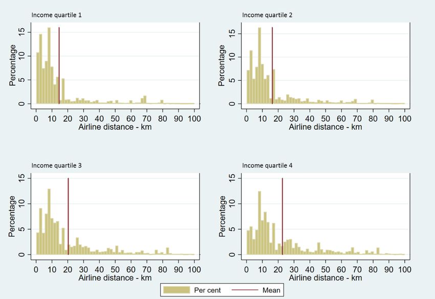
Figure 10: Employment search space for the City of Cape Town (2017 tax year)

Source: authors’ construction based on aggregated main place level (2017 tax year) data
(‘density_ZA_2017.dta’).

Figure 11 indicates the different airline distances by income quartiles. It shows that lower-income
groups travel shorter distances (average of 15 km), with very few low-income workers residing
more than 30 km from their workplace. In comparison, higher-income workers (income quartiles
3 and 4) travel 22 km on average.

 23
Figure 11: Frequency by airline distance between an employee’s residence and workplace for different income
quartiles (2017 tax year, trips shorter than 100 km)

Notes: income Q1 = gross_income ≤ ZAR33,953 per year; income Q2 = gross_income > ZAR33,953 and
gross_income ≤ ZAR87,099 per year; income Q3 = gross_income > ZAR87,099 and gross_income ≤
ZAR254,182 per year; income Q4 = gross_income > ZAR254,182. Data also available for tax years 2013–16.
Source: authors’ construction based on IRP5_Merge_2017 dataset.

Figure 12 indicates the airline distance profiles of employees who travel to their place of
employment for the major metropolitan 23 areas in South Africa. The figure indicates that the
average airline distances for commuters in Cape Town and eThekwini are lower, with mean airline
distances of 15 km and 10 km respectively. Commuters who work in the City of Tshwane travel
on average the longest, with an average airline distance of 25 km.

23
 The metropolitan represents the metro in which the employer is situated, not necessarily where the employee resides.
 24
Figure 12: Frequency by airline distance between an employee’s residence and workplace for different
metropolitans (2017 tax year, trips shorter than 100 km)

Note: data also available for tax years 2013–16.
Source: authors’ construction based on IRP5_Merge_2017 dataset.

Figure 13 indicates the airline distance according to the different geographical classifications and
shows significant differences between metropolitan, urban, and rural areas. It indicates that people
in rural areas either commute less than 5 km (which makes non-motorized transport a viable mode
of choice) or must travel very great distances relative to metropolitan or urban areas. The figure
also indicates that 50 per cent of individuals travel more than 20 km in rural areas compared with
the median of 10 km for individuals employed in urban or metro areas.

 25
Figure 13: Frequency by airline distance between an employee’s residence and workplace for different
geographical classifications (2017 tax year, trips shorter than 100 km)

Note: data also available for tax years 2013–16.
Source: authors’ construction based on IRP5_Merge_2017 dataset.

5.3 Correlation analysis, pairwise mean comparisons, and regression analysis

In this section we extend the descriptive analysis by investigating the relationship between airline
distance and employment duration controlling for the influence of other relevant variables.

Table 9 shows that the linear relationship between airline distance and employment duration
(measured in days) is weak but significant (at a 5 per cent significance level). An increase of 1 km
in distance will result in an increase of 0.0685 days’ employment duration for all income groups.
This finding appears counterintuitive and rejects the hypothesis that increased travel distance will
result in lower employment duration. But, as we showed above, there is a complex relationship
between income quartiles and employment, and here too the coefficients change signs when
differentiating between income quartiles. This indicates that there is a significant negative linear
relationship between employment duration and airline distance for income quartiles 1 and 2 (lower-
income groups) and a positive relationship for income quartiles 3 and 4 (higher-income groups).

As discussed, this may reflect the employment search space dynamics. The more the employment
search space increases, the more likely individuals will be to access higher-paying jobs and jobs
they prefer (in terms of location, flexibility, other non-monetary benefits, etc.). The flexibility of
the private vehicle will facilitate this larger employment search space. Individuals will therefore be
more likely to stay employed longer in these jobs, which supports the positive relationship between
airline distance and employment duration. The negative coefficients for low-income categories
contrast with the higher-income results. As distance increases, transport costs increase (travel time
and price of the trips). As the ‘costs of employment’ increase with commuting costs, lower-income
households may not be able to absorb these costs, which results in shorter employment duration.

 26
These relationships remain weak, but do, however, indicate that travel distance has a negative
impact on employment duration for lower-income groups. Other factors may influence
employment duration for high-income groups.
Table 9: Pairwise correlation between employment duration (days) and airline distance by income quartiles (2017
tax year)

Pairwise correlation All income Income Q1 Income Q2 Income Q3 Income Q4
 groups
Airline distance 0.0685 −0.0270 −0.0118 0.0394 0.0138
(km)

Notes: income Q1 = gross_income ≤ ZAR33,953 per year; income Q2 = gross_income > ZAR33,953 and
gross_income ≤ ZAR87,099 per year; income Q3 = gross_income > ZAR87,099 and gross_income ≤
ZAR254,182 per year; income Q4 = gross_income > ZAR254,182. Only includes trips with an airline distance of
100 km or less. Significant at 5% level.
Source: authors’ construction based on IRP5_Merge_2017 dataset.

Table 10 compares employment duration for employees who live and work in the same main place
with duration for those who travel between main places, by different income quartiles. It is
assumed that individuals who live and work in the same main place will have better accessibility
than individuals who travel between main places. The results indicate a 16-day difference in mean
employment duration for individuals who fall into the lowest income quartile and an eight-day
difference for commuters in the second income quartile. For income quartiles 3 and 4, however,
the results reinforce the findings of Table 9, and the mean employment duration increases when
travel distance increases. This may be a result of higher-income earners having access to private
vehicle usage, which allows them to access better job opportunities even though these may be at
a greater distance. The results again indicate that higher- and lower-income employees have
different characteristics in terms of employment duration and distance. While higher-income
individuals—predominately private car users—can access more, and a wider choice of,
employment opportunities, they are more likely to travel further to their workplace.

The result confirms the hypothesis that increased transport accessibility, measured here by whether
an individual resides and works in the same main place, results in higher employment duration for
lower-income groups.
Table 10: Pairwise mean test between employment duration and whether an employee lives and works in the
same main place by income quartile (2017 tax year)

Employment duration (days) Mean (employment duration)
 Income Q1 Income Q2 Income Q3 Income Q4
Lives and works MP_OD_equal==0 150,977 292,179 313,269 321,325
in different main
place
Lives and works MP_OD_equal==1 166,980 300,377 303,025 316,053
in same main
place
P > |t| MP_OD_equal: 1 vs 0 0.000* 0.000* 0.000* 0.000*

Note: * significant at 5% level.
Source: authors’ construction based on IRP5_Merge_2017 dataset.

A regression analysis was conducted to analyse the relationship between individual demographic
characteristics, employment, transport accessibility, and location variables in the
IRP5_Merge_2017 dataset on employment duration. Table 11 describes the variables used within
this regression analysis.

 27
You can also read