Thurrock Joint Strategic Needs Assessment Demographics and Population Change - Thurrock Council
←
→
Page content transcription
If your browser does not render page correctly, please read the page content below
Thurrock

Joint Strategic Needs Assessment

Demographics and Population Change

Key Contact:
Maria Payne, Health Needs Assessment Manager, Public Health Team – publichealth@thurrock.gov.uk /
01375 652626

                                                                                               1
                                                                  th
V2.0           Approved by Thurrock Health and Wellbeing Board on 15 June 2015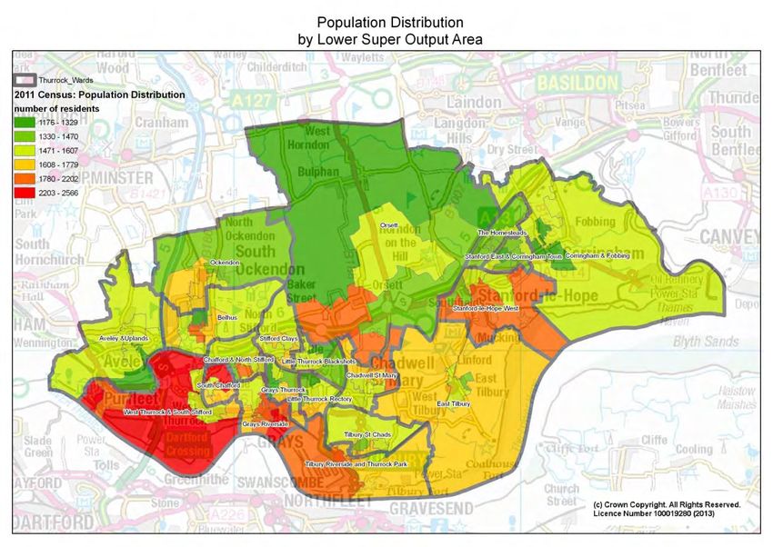
Contents
Introduction to the JSNA                                                             4
Executive Summary                                                                    4
Recommendations                                                                      6
1      Location                                                                      7
2      Population                                                                    8
    2.1    Age Structure                                                             8
       2.1.1      Mid Year Estimates                                                 8
       2.1.2      Census 2011 Age Structure and Change                               9
       2.1.3      Geographical Distribution of Thurrock’s Population                 11
       2.1.4      Geographical distribution of key age groups                        12
    2.2    Gender                                                                    14
    2.3    Ethnic Group                                                              15
    2.4    Population Projections.                                                   16
       2.4.1      Projected Change in Age Structure                                  16
       2.4.2      Key Care Groups                                                    18
    2.5    Components of Population Change                                           19
       2.5.1      Natural Change                                                     20
       2.5.2      Internal Migration                                                 20
       2.5.3      International Migration                                            21
3      Births and Deaths                                                             24
    3.1    Births                                                                    24
    3.2    Deaths                                                                    25
       3.2.1      Premature mortality                                                27
4      Tenure and Household Structure                                                29
    4.1    Tenure                                                                    29
    4.2    Household Structure                                                       29

                                                                                      2
                                                                       th
V2.0               Approved by Thurrock Health and Wellbeing Board on 15 June 2015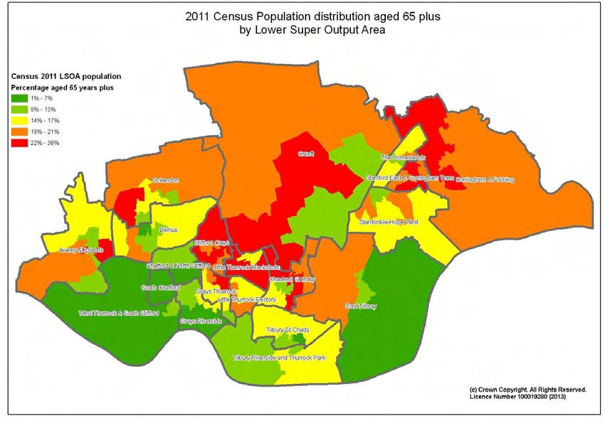
Figure 1: Thurrock                                                                                                                                                                              7
Figure 2: Population Pyramid by Quinary Age-Group in Thurrock and England                                                                                                                       9
Figure 3: Percentage change in age groups between 2001 and 2011                                                                                                                                11
Figure 4: ONS 2011 Population Distribution by Lower Super Output Area                                                                                                                          12
Figure 5: Population Distribution for people aged under 15 years by Lower Super Output Area                                                                                                    13
Figure 6: Population Distribution for people aged 65 years plus by Lower Super Output Area                                                                                                     14
Figure 7: 2001 Condensed Ethnic Groups        Figure 8: 2011 Condensed Ethnic Groups                                                                                                           15
Figure 9: Population Projections, 2012-2022                                                                                                                                                    16
Figure 10: Population Projection Age Structure 2012-2022                                                                                                                                       17
Figure 11: Population Projections by Key Care Group – Younger People 2012-2022                                                                                                                 18
Figure 12: Population Projections by Key Care Group – Older People 2012-2022                                                                                                                   19
Figure 13: Natural Change: Components of population change between 2002 and 2014                                                                                                               20
Figure 14: Internal migration between 2002 and 2014                                                                                                                                            21
Figure 15: International Migration between 2002 and 2014                                                                                                                                       22
Figure 16: National Insurance Registrations to overseas nationals entering the UK                                                                                                              22
Figure 17: Number of Thurrock residents arriving in UK by country of birth                                                                                                                     23
Figure 18: Trend in General Fertility Rate, 2010-2013                                                                                                                                          24
Figure 19: Fertility Rates by ward, 2008-2012                                                                                                                                                  25
Figure 20: Standardised Mortality Ratios for Thurrock, East of England and England by gender, 2013                                                                                             26
Figure 21: Deaths from all causes in Thurrock by ward, 2008-2012, Standardised Mortality Ratios                                                                                                27
Figure 22: Mortality in those aged under 75 years, 2010-12                                                                                                                                     28
Figure 23: People aged 65 and over predicted to live alone by gender, 2014-2030                                                                                                                32

Table 1: 2014 Mid-Year Estimates ONS by Age-Group .......................................................................................................................8
Table 2: Age Structure Change between 2001 and 2011 Census ...................................................................................................... 10
Table 3: Gender Structure Change between 2001 and 2011 Census ................................................................................................ 14
Table 4: Changes in Ethnic Groups between Census (2001 and 2011) .............................................................................................. 15
Table 5: Proportion of Thurrock residents by age group in 2012 and 2022 ...................................................................................... 17
Table 6: Components of change 2013-2014 ..................................................................................................................................... 19
Table 7: Change in Directly Standardised Mortality Rates (DSRs) for Males and Females between 2000 and 2012 in Thurrock and
     England. .................................................................................................................................................................................. 26
Table 8: Tenure change between 2001 and 2011 Census ................................................................................................................. 29
Table 9: Household Structure Change between 2001 and 2011 Census ........................................................................................... 30

                                                                                                                                                                                                 3
                                                                                                                     th
V2.0                     Approved by Thurrock Health and Wellbeing Board on 15 June 2015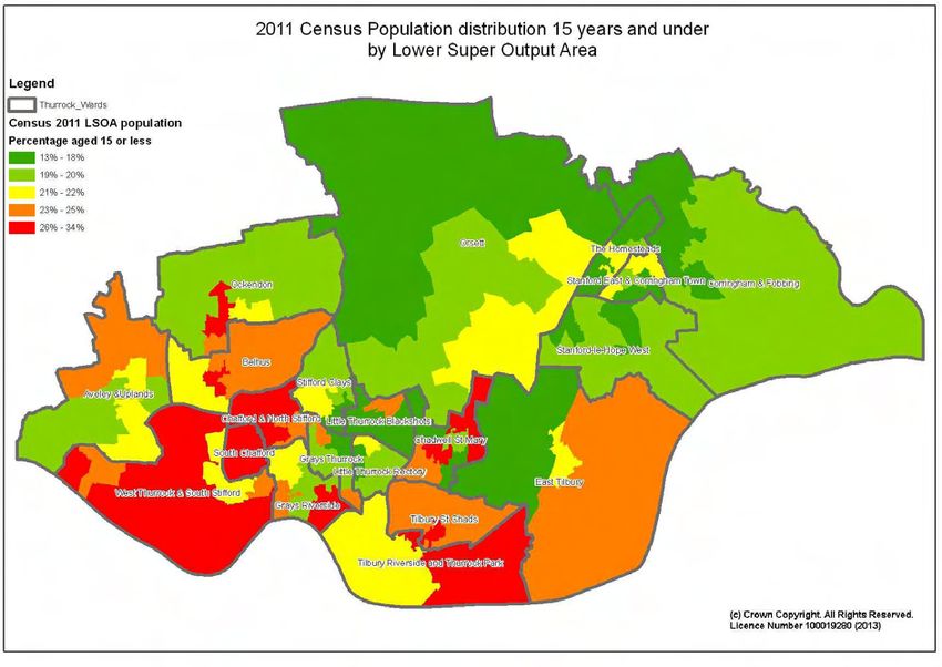
Introduction to the JSNA
The Joint Strategic Needs Assessment (JSNA) is an assessment of the current and future health and social
care needs of the local community – these are needs that could be met by the local authority, Clinical
Commissioning Groups (CCGs), or NHS England. It is intended to provide a shared, evidence based
consensus about key local priorities and support commissioning to improve health and well-being outcomes
and reduce inequalities. In order to appropriately identify needs within our local community, it is paramount we
review the demographic structure. This chapter sets to profile the demography of Thurrock showing projections
for the future. This will inform other chapters within the JSNA as well as provide a baseline for commissioning
priorities.
Executive Summary
Age Structure
In 2014 the total population of Thurrock was 163,270 (ONS mid-year estimates 2014) of which 80,424
(49.3%) were male and 82,846 (50.7%) female.
Thurrock’s age structure is similar to that of, regional and national figures but generally has a larger
young population aged 0-19 years – particularly 0-4 year olds, and a larger population in their 30s and
early to mid-40s than both East of England and England. Conversely, Thurrock has a smaller
proportion of older people than both East of England and England.
Population Distribution
The population is not evenly distributed across the borough - there are more densely populated areas
within the southern and central areas of Thurrock.
The areas with the highest percentage of under 15s in Thurrock are heavily clustered around the south
and south west of the borough including the wards of Tilbury St Chads, Chafford and North Stifford,
South Chafford and West Thurrock and South Stifford where up to 34% of the population fall within this
age group.
The highest proportion of the over 65s (22-36%) reside in the north of the borough in areas such as
Orsett, Corringham and Fobbing.
Population Change between the 2001 and 2011 Census
There has been a 20% increase in 0-4 year olds between 2001 and 2011 (equating to almost 2,000
additional residents in this age group since 2001). This age group makes up 7.6% of the Thurrock’s
population which is greater than the proportion of the national population.
The borough’s population aged 60 years and above has increased by 16.5% since 2001. However, the
proportions of people in each of the 60+ age groups are lower than the England and East of England
averages.
There has been a 47.5% increase in the over 85 population, equating to 846 more residents in this age
group since 2001.
Population Projections
The ONS subnational population projections (2012) estimate that, from 2012, the total population will
increase to 176,500 by 2022 and 192,535 by 2032 (an increase of 10.6% and 20.7% respectively).
The population is predicted to increase for almost all quinary age groups. However, the most significant
increases occur in age groups clustered in the 0-14, 25-29, 50-59 and 70 and over age groups. As a
4
th
V2.0 Approved by Thurrock Health and Wellbeing Board on 15 June 2015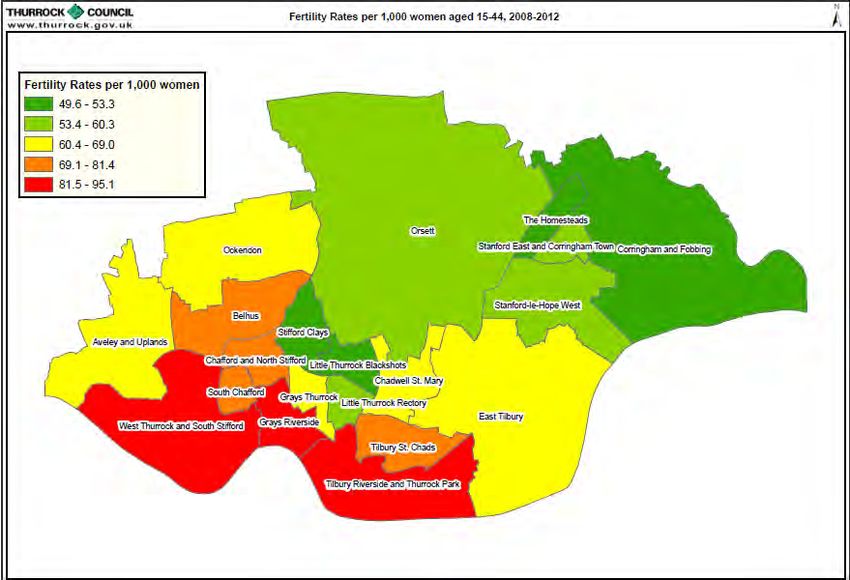
proportion of the total population, the largest percentage increases from 2012 to 2022 are predicted to
occur in the 5-9, 50-54 and 70-74 years age groups.
Ethnic groups
Despite an overall population increase, the White British and Irish groups have decreased in number
from 134,348 residents representing 93.9% of the resident Thurrock population in 2001 to 128,348 in
2011 representing 81.6% of the total population. All other main groups have increased both in number
and proportion, particularly within the Black groups and Other White Group.
Components of population change
The number of births in Thurrock has continued to increase, from 1,852 births in 2001, to 2,359 in 2014.
The number of deaths has decreased from 1,216 in 2001 to 1,147 in 2014.
The natural population change (births minus deaths) shows a large increase in number of people from
636 in 2001 to 1,212 in 2014. This accounted for 14,110 additional residents between 2001 and 2014.
There has been substantial movement of people from London to Thurrock, particularly from
geographically close boroughs, including Havering, Barking and Dagenham and Newham. The London
boroughs as a whole account for over 50% of all internal migration into Thurrock.
Since 2001, ONS has estimated that international migration into Thurrock has varied from about 500
people annually in 2001, rising to a peak of 1,300 in 2006/7, before decreasing to 940 in 2013/14.
Tenure
There has been a small increase in number of total households rising from 58,485 to 62,353 between
2001 and 2011: a 3.6% increase.
There has been a significant rise in the proportion of private rented sector housing from 5.9% in 2001 to
13.2% in 2011. The number of households in this sector has risen from 3,456 to 8,220 representing an
increase of 137.9%.
Household Structure
There has been a 12.5% decrease in one person households aged 65 and older, and a 9.7% decrease
in family households all aged 65 and over, together representing 10,379 households in 2011. The
overall borough household proportion for both of these groups is substantially less than for either the
East of England or England.
Lone parent households with dependent children have increased by 880 to 4,744 in 2011, representing
a rise of 22.7% between 2001 and 2011. Thurrock has 7.6% lone parent households with dependent
children, which is a slightly higher proportion than for the East of England but similar to the 7.1% for
England.
5
th
V2.0 Approved by Thurrock Health and Wellbeing Board on 15 June 2015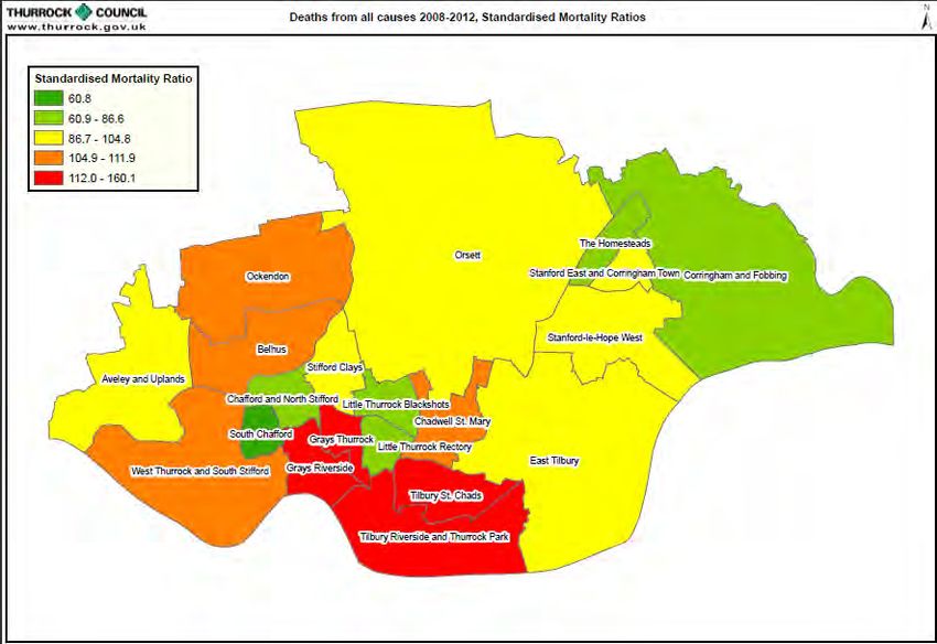
Recommendations
 This JSNA product shows the dynamic and changing nature of the population of Thurrock. This
 demographic information, with relevant updates where necessary, will need to feed into our updated Health
 and Wellbeing Strategy for Thurrock (currently under production), which will come back to the Health and
 Wellbeing Board later in 2015 for discussion and agreement.

 Key Points:

       1. Thurrock has a larger young population aged 0-19 years – particularly 0-4 year olds, and a larger
          population in their 30s and early to mid-40s than both East of England and England.

       2. There has been a 47.5% increase in the over 85 population between 2001 and 2011, equating to
          846 more residents in this age group.

       3. The ONS subnational population projections (2012) estimate that, from 2012, the total population will
          increase to 176,500 by 2022 and 192,535 by 2032.

       4. Ethnic diversity is increasing in Thurrock - all main ethnic groups excluding White British and Irish
          groups have increased both in number and proportion, particularly within the Black groups and Other
          White Group.

       5. The births in Thurrock have continued to increase, from 1,852 births in 2001, to 2,359 in 2014.

       6. There has been substantial movement of people from London to Thurrock, particularly from
          geographically close boroughs.

       7. There has been a significant rise in the proportion of private rented sector housing from 5.9% in
          2001 to 13.2% in 2011. The number of households in this sector has risen from 3,456 to 8,220
          representing an increase of 137.9%.

       8. Lone parent households with dependent children have increased by 880 to 4,744 in 2011,
          representing a rise of 22.7% between 2001 and 2011.

                                                                                                                  6
                                                                     th
V2.0            Approved by Thurrock Health and Wellbeing Board on 15 June 2015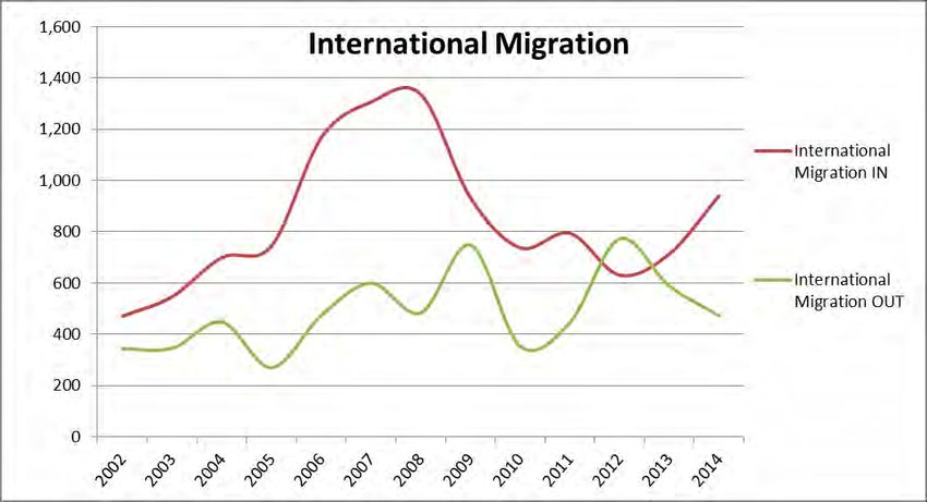
1 Location
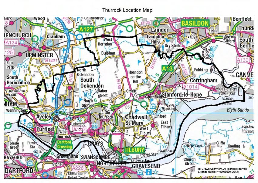
Thurrock is situated in the south of Essex and lies to the east of London on the north bank of the River Thames
with an area of 165 square kilometres. It has a diverse and growing population with a population density of 976
persons per square kilometre. Figure 1 shows Thurrock and its surrounding areas.
Figure 1: Thurrock

                                                                                                              7
                                                                  th
V2.0          Approved by Thurrock Health and Wellbeing Board on 15 June 2015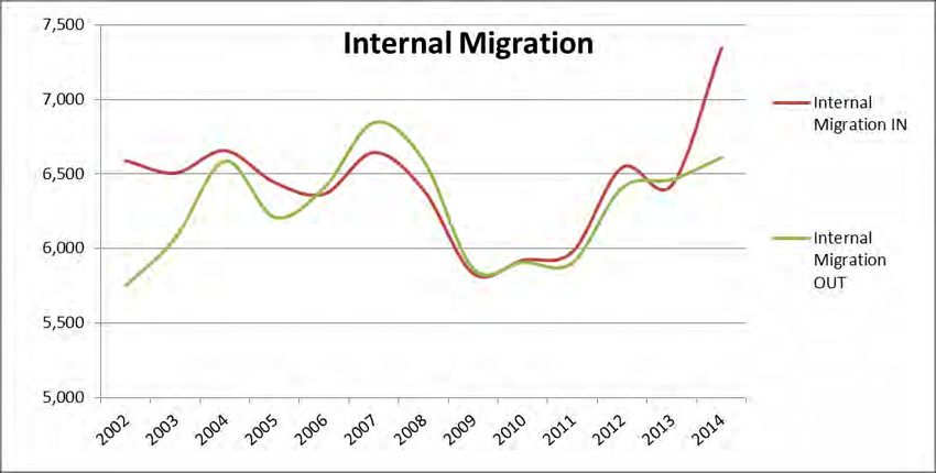
2 Population
This section describes the population of Thurrock by age, gender, and ethnic group.

2.1 Age Structure
Three key sources are used in this section: the Office for National Statistics (ONS) mid-year estimates and the
ONS Census for 2011 and 2001. A summary of the age structure for the authority as a whole is provided
together with the key changes over 10 years to 2011. The distribution of the total population and key age
groups in Thurrock is then described.

2.1.1 Mid Year Estimates
Table 1 shows the age profile of the total population by sex and age-group. The total 2014 mid-year estimated
population of Thurrock was 163,270 of which 80,424 (49.3%) were males and 82,846 (50.7%) females. This is
the latest population estimate for the authority and is published annually.

Table 1: 2014 Mid-Year Estimates ONS by Age-Group

             Males               Females         Persons Males    Females Persons
 Age                                                      % of      % of   % of
 Group       Number              Number          Number males     females persons
     0-4              6,327           6,045       12,372   7.9%     7.3%     7.6%
     5-9              5,905           5,871       11,776   7.3%     7.1%     7.2%
 10 - 14              4,983           4,791        9,774   6.2%     5.8%     6.0%
 15 - 19              5,114           4,917       10,031   6.4%     5.9%     6.1%
 20 - 24              4,844           4,772        9,616   6.0%     5.8%     5.9%
 25 - 29              5,365           5,948       11,313   6.7%     7.2%     6.9%
 30 - 34              5,697           6,382       12,079   7.1%     7.7%     7.4%
 35 - 39              5,926           6,180       12,106   7.4%     7.5%     7.4%
 40 - 44              6,089           6,104       12,193   7.6%     7.4%     7.5%
 45 - 49              6,356           6,119       12,475   7.9%     7.4%     7.6%
 50 - 54              5,370           5,153       10,523   6.7%     6.2%     6.4%
 55 - 59              4,405           4,265        8,670   5.5%     5.1%     5.3%
 60 - 64              3,999           3,994        7,993   5.0%     4.8%     4.9%
 65 - 69              3,746           3,887        7,633   4.7%     4.7%     4.7%
 70 - 74              2,355           2,733        5,088   2.9%     3.3%     3.1%
 75 - 79              1,816           2,169        3,985   2.3%     2.6%     2.4%
 80 - 84              1,209           1,668        2,877   1.5%     2.0%     1.8%
 85 - 89                655           1,166        1,821   0.8%     1.4%     1.1%
     90 +               263                682      945    0.3%     0.8%     0.6%
    Total           80,424           82,846      163,270 100.0%   100.0%   100.0%
Source: ONS mid-year estimates

                                                                                                              8
                                                                      th
V2.0              Approved by Thurrock Health and Wellbeing Board on 15 June 2015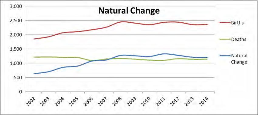
Figure 2 shows a population pyramid which depicts the age structure of Thurrock in 2014 compared to that of
England. Whilst the pyramids are similar there are some clear differences: Thurrock has a relatively young
population with almost all the quinary age groups under 50 years forming a greater proportion of the total
population compared to England; and conversely the age groups over 50 years forming a lower proportion of
the total population compared to England.

Figure 2: Population Pyramid by Quinary Age-Group in Thurrock and England

Source: ONS mid-year estimates

2.1.2 Census 2011 Age Structure and Change
Whilst the mid year estimates provide the latest population figures, the 2011 Census is a much richer source of
information.

Table 2 describes the change in age structure between 2001 and 2011.

                                                                                                              9
                                                                     th
V2.0              Approved by Thurrock Health and Wellbeing Board on 15 June 2015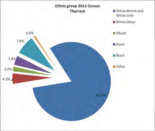
Table 2: Age Structure Change between 2001 and 2011 Census
Thurrock (Number) Number % Increase Thurrock (%) East of England
Increase / / Decrease England (2011)
Decrease in number (2011)
2011 2001 2011 2001
All People 157,705 143,128 14,577 10.2%
0-4 12,005 10,008 1,997 20.0% 7.6% 7.0% 6.2% 6.3%
5-7 6,428 5,817 611 10.5% 4.1% 4.1% 3.4% 3.4%
8-9 3,803 3,785 18 0.5% 2.4% 2.6% 2.2% 2.2%
10-14 9,949 9,956 -7 -0.1% 6.3% 7.0% 5.9% 5.8%
15 2,113 1,862 251 13.5% 1.3% 1.3% 1.3% 1.2%
16-17 4,117 3,463 654 18.9% 2.6% 2.4% 2.5% 2.5%
18-19 3,623 3,060 563 18.4% 2.3% 2.1% 2.3% 2.6%
20-24 9,804 8,839 965 10.9% 6.2% 6.2% 6.0% 6.8%
25-29 11,162 11,106 56 0.5% 7.1% 7.8% 6.2% 6.9%
30-44 36,566 33,944 2,622 7.7% 23.2% 23.7% 20.2% 20.6%
45-59 29,375 26,605 2,770 10.4% 18.6% 18.6% 19.8% 19.4%
60-64 8,739 6,004 2,735 45.6% 5.5% 4.2% 6.4% 6.0%
65-74 10,738 9,975 763 7.6% 6.8% 7.0% 9.1% 8.6%
75-84 6,657 6,924 -267 -3.9% 4.2% 4.8% 6.0% 5.5%
85-89 1,844 1,212 632 52.1% 1.2% 0.8% 1.6% 1.5%
90 and over 782 568 214 37.7% 0.5% 0.4% 0.8% 0.8%
Source: Census 2011 and 2001
There has been a 20% rise in 0-4 year olds between 2001 and 2011. This age group makes up 7.6% of
the Thurrock’s population which is greater than the England average.
The borough’s population aged over 60 years has increased by 16.5% since 2001. However, the
proportions of people in each of the 60+ age groups are less than the England and East of England
averages.
There has been a 47.5% increase in the over 85 population.
The percentage change for each age group is depicted in
Figure 3.
10
th
V2.0 Approved by Thurrock Health and Wellbeing Board on 15 June 2015Figure 3: Percentage change in age groups between 2001 and 2011
Percentage change in Thurrock population by age group
60.0%
50.0%
40.0%
Percentage(%)
30.0%
20.0%
10.0%
0.0%
-10.0%
Age group
Source: Census 2011 and 2001
2.1.3 Geographical Distribution of Thurrock’s Population
The population density and distribution in Thurrock varies considerably from low density in the more rural areas
to high in the urban areas. At the time of the 2001 Census, the average population density in Thurrock was
measured at 8.8 persons per hectare compared to 9.7 persons per hectare in the 2011 census, demonstrating
the recent increase in population. Distribution of population by Lower Super Output Area is shown in Figure 4
highlighting that generally the southern and central areas of Thurrock have the wards with the largest numbers
of residents, often in quite small, built up areas such as within the Grays Riverside ward. When planning
services, deprivation levels of an area should also be taken into account, as these are also not uniform across
the borough. An overview of levels of deprivation within Thurrock will be found within the future Wider
Determinants JSNA chapter.
11
th
V2.0 Approved by Thurrock Health and Wellbeing Board on 15 June 2015Figure 4: ONS 2011 Population Distribution by Lower Super Output Area
Source: Census 2011
2.1.4 Geographical distribution of key age groups
This section provides the geographical distribution of two key age groups: under 15s and 65 years and over.
Health needs differ for both of these groups and it is useful to understand how the proportion of each varies
geographically to aid in targeting resources. The maps below show this distribution by Lower Super Output
Area.
2.1.4.1Population aged under 15 years
Figure 5 illustrates that the areas with the highest percentage of under 15s in Thurrock are heavily clustered
around the south and south west of the borough including the wards of Tilbury St. Chads, Chafford and North
Stifford, South Chafford and West Thurrock and South Stifford where up to 34% of the population fall within
this age group. This impacts on the type of services commissioned within those areas for the under 15s.
[Further information on the child population in Thurrock is detailed in the Children’s JSNA Chapter.]
12
th
V2.0 Approved by Thurrock Health and Wellbeing Board on 15 June 2015Figure 5: Population Distribution for people aged under 15 years by Lower Super Output Area
Source: Census 2011
2.1.4.2Population aged over 65 years
Figure 6 shows population distribution of those aged 65 and over by LSOA across Thurrock. The highest
proportion of the over 65s (22-36%) reside in the north of the borough in areas such as Orsett, Corringham and
Fobbing. Although the impact of the ageing population on health and social services is difficult to predict, it
gives an idea of how services for this population group might be planned and prioritised. Work is underway in
reviewing how health and social care services will work more closely together to provide better services for this
age group. [Further information on the population aged over 65 years in Thurrock will be detailed in the
Thurrock Annual Public Health Report 2014]
13
th
V2.0 Approved by Thurrock Health and Wellbeing Board on 15 June 2015Figure 6: Population Distribution for people aged 65 years plus by Lower Super Output Area
Source: Census 2011
2.2 Gender
In 2011 there was almost a 50/50 split between males and females. Since 2001 the male population has
increased by 11.7%, whereas the female population has increased by 8.7%. When comparing the proportions
of males and females in Thurrock to regional and national proportions, it can be seen that Thurrock has a
higher proportion of males than both East of England and England populations.
Table 3: Gender Structure Change between 2001 and 2011 Census
Thurrock (Number) number % Increase Thurrock (%) East of England
Increase / / Decrease England (2011)
Decrease in number (2011)
2011 2001 2011 2001
Total 157,705 143,128 14,577 10.2%
Male 77,823 69,669 8,154 11.7% 49.3% 48.7% 48.4% 48.7%
Female 79,882 73,459 6,423 8.7% 50.7% 51.3% 51.6% 51.3%
Source: Census 2011 and 2001
14
th
V2.0 Approved by Thurrock Health and Wellbeing Board on 15 June 20152.3 Ethnic Group
An understanding of a population’s ethnic diversity is important as it is recognised that there is variation on the
impact of some wider determinants of health, health behaviour and health conditions across different ethnic
groups. Over that last decade, ethnic diversity in Thurrock has increased at a rate faster than the national
average.
Table 4 shows the main changes between the 2001 and 2011 Census, while Figure 7 and 8 depict the relative
proportions of ethnic groups in 2001 and 2011. Despite an overall population increase, the White British and
Irish groups have declined in number from 134,348 residents representing 93.9% of the resident Thurrock
population in 2001 to 128, 348 in 2011 representing 81.6% of the total population. All other main groups have
increased both in number and proportion, particularly within the Black groups and Other White Group.
Table 4: Changes in Ethnic Groups between Census (2001 and 2011)
Main Ethnic group
2011 2001 2001 to 2011
number number
of % of total of % of total
residents population residents population absolute change
White:British and White:Irish 128,695 81.6% 134,348 93.9% -5,653
White: Other 6,734 4.3% 2,051 1.4% 4,683
Mixed 3,099 2.0% 1,319 0.9% 1,780
Asian 5,927 3.8% 3,405 2.4% 2,522
Black 12,323 7.8% 1,659 1.2% 10,664
Other 927 0.6% 346 0.2% 581
TOTAL 157,705 100.0% 143,128 100.0% 14,577
Figure 7: 2001 Condensed Ethnic Groups Figure 8: 2011 Condensed Ethnic Groups
Source: Census 2011 and 2001
15
th
V2.0 Approved by Thurrock Health and Wellbeing Board on 15 June 2015The increase in the proportion of many ethnic groups can in part be attributed to substantial inward migration to
Thurrock from East London coupled with rising levels of international migration mainly from parts of Africa and
Eastern Europe. The pattern of international and internal migration is described in more detail in sections 2.5.2
and 2.5.3.
2.4 Population Projections.
Population projections estimate the future population of an area. This is useful to inform commissioners of
major future trends that may affect health, social and economic development of an area and assess future
demands on services. It enables commissioners to incorporate these demands and trends in planning
processes to meet population need / demand. It helps raise awareness of issues such as affordable housing
and fuel consumption among policy makers and initiate policy dialogue and effective and efficient service
provision. The official population projections at local authority level are produced every 2 years by the ONS.
They are trend based projections and take no account of changes in availability of housing. The latest official
projections are the 2012 Subnational Population Projections, released in 2014. The following information
shows the projections up to 2022; although they are available up to 2037.
Figure 9 shows projections from 2012 to 2022. The population of Thurrock is projected to grow to 176,508 by
2022. This equates to an increase of 11% or about 16,975 people over the 10 years. This will require health
and local government partners to ensure appropriate additional levels of service provision and supporting
infrastructure, e.g. transport housing, health, schools, leisure and cultural facilities.
It is important to note that these projections are trend based and do not take into account future planned
development or regeneration. The projections do indirectly pick up the effect of new housing as it is built and
occupied, which consequently readjusts the trend reflecting the increase in the availability of housing, but
change in the rate of regeneration planned for the future is not accounted for. A number of regeneration plans
are in place for the borough which will impact on the size and demography of the local population – these will
be further described in the Wider Determinants JSNA.
Figure 9: Population Projections, 2012-2022
Change in Thurrock population 2012-2022 176,508
174,760
172,988
180,000
171,211
169,453
167,703
175,000
Population number
165,975
164,265
162,634
170,000
161,024
159,533
165,000
160,000
155,000
150,000
2012 2013 2014 2015 2016 2017 2018 2019 2020 2021 2022
Source: ONS Subnational population projections; 2012
2.4.1 Projected Change in Age Structure
16
th
V2.0 Approved by Thurrock Health and Wellbeing Board on 15 June 2015The age and sex distribution within our population has an impact on the level of need for health services. Older
people and the very young tend to have a greater utilisation of health services. An increase in a younger
population indicates opportunities to maximise an Early Offer of Help and prevent future ill health, in line with
local authority public health responsibilities. An increase in the older population has implications for service
provision and the levels and ways that care and social services are provided to meet needs.
Figure 10 shows the projected change from 2012 to 2022, by five year age group. Clearly there is predicted to
be a rise in number for almost every age group. However, the most significant rises occur in age groups
clustered in the 0-14, 25-29, 50-59 and 70 plus age groups.
Figure 10: Population Projection Age Structure 2012-2022
Absolute change in number of residents 2012-2022
by 5 year age group
Persons 2012 Persons 2022
14,000
number of residents
12,000
10,000
8,000
6,000
4,000
2,000
0
Age group
Source: Subnational Population projections; ONS; 2012
Table 5 shows the same information as Figure 10 but each 5 year age group is shown as a percentage of the
total population for the years 2012 and 2022. The key differences are:
In 2022 there is predicted to be a higher percentage of 5-9 year olds, 50-59 year olds, 65-84 year olds
and 90 years and over.
In 2022 there is predicted to be a lower percentage of 15-29 year olds and 30-49 year olds.
Table 5: Proportion of Thurrock residents by age group in 2012 and 2022
Age Group % of population in 2012 % of population in 2022
0-4 7.7% 7.0%
5-9 6.8% 7.0%
10 - 14 6.1% 6.9%
15 - 19 6.3% 5.9%
20 - 24 6.0% 5.1%
25 - 29 7.0% 6.5%
30 - 34 7.5% 7.3%
35 - 39 7.5% 7.2%
40 - 44 7.8% 7.0%
45 - 49 7.5% 6.6%
17
th
V2.0 Approved by Thurrock Health and Wellbeing Board on 15 June 201550 - 54 6.2% 6.8%
55 - 59 5.3% 6.5%
60 - 64 5.2% 5.2%
65 - 69 4.4% 4.2%
70 - 74 3.0% 3.9%
75 - 79 2.4% 3.1%
80 - 84 1.8% 1.9%
85 - 89 1.1% 1.2%
90+ 0.5% 0.8%
Total 100.0% 100.0%
Source: ONS Subnational Population projections; 2012
2.4.2 Key Care Groups
This section provides detail on projected change for the younger population (0-19 years) and the older
population (50 years and over) up to 2022. Each of these overall age groups is subdivided into smaller groups
as there are some key differences within them.
2.4.2.1Residents aged 19 years and under
Figure 11 shows the ONS absolute population projections up to 2022 by four age bands for the 0-19
population. Thurrock currently has a significantly greater proportion of young people than England and this
trend is likely to continue into the future. The 5-14 year age groups, particularly, are predicted to increase
sharply over the 10 years from 2012.
Figure 11: Population Projections by Key Care Group – Younger People 2012-2022
Population Projections, Key Care Age groups 0 to 19 years
13000
number of residents
12000
11000
0-4
10000
5 to 9
9000
8000 10 to 14
15 to 19
year
Source: Subnational Population projections; ONS; 2012
18
th
V2.0 Approved by Thurrock Health and Wellbeing Board on 15 June 20152.4.2.2 Residents aged 50 years and over:
Figure 12 shows the ONS absolute population projects for four age bands for the population aged 50 years
and over. As the figure shows, Thurrock will see a significant ageing of its population among the key older care
groups – 50-64, 65-74, 75–84 and 85+, all of which will increase in absolute terms and as a proportion of the
population.
By 2022, the population group aged 50-64 is projected to increase by 5,900, which is an 18% increase, and the
population group aged 75-84 is projected to increase by 2,139 (26%).
Figure 12: Population Projections by Key Care Group – Older People 2012-2022
Population Projections, Key Care Age groups 50 years and over
35,000
30,000
Number of residents
25,000
20,000
50-64
15,000 65-74
10,000 75-84
5,000 85plus
0
Year
Source: ONS Subnational Population projections; 2012
2.5 Components of Population Change
Population change reflects the influence of several different components. The principal components of change
are births and deaths (reflecting fertility and mortality rates), and internal and international migration. This
section describes the effect these components have on the population of Thurrock.
Table 6 shows the details of these components of population change for the latest 2014 mid-year estimates.
Table 6: Components of change 2013-2014
2013 2014
Population 160,849 163,270
Natural Change 1,212
Births 2,359
Deaths 1,147
All Migration NET 1,201
19
th
V2.0 Approved by Thurrock Health and Wellbeing Board on 15 June 2015Internal Migration In 7,345
Internal Migration Out 6,612
International Migration In 940
International Migration Out 472
Source: ONS
2.5.1 Natural Change
The main reason for a net population increase has been the process of natural change which is the difference
between the number of births and number of deaths in an area. Figure 13 shows the natural change between
2002 and 2014. The net effect of these components (births minus deaths) shows a large increase from 636 in
2002 to 1,212 in 2014. Further information on births and deaths in Thurrock is provided further down in this
chapter.
Figure 13: Natural Change: Components of population change between 2002 and 2014
Source: ONS mid-year estimates
2.5.2 Internal Migration
Internal migration defines movement of people between one area of England and Wales to another. This is
principally measured by changes in home address registered with a General Practitioner. Figure 14 shows
movement in and out of Thurrock within England and Wales for each year between 2002 and 2014.
20
th
V2.0 Approved by Thurrock Health and Wellbeing Board on 15 June 2015Figure 14: Internal migration between 2002 and 2014
Source: ONS mid-year estimates
6,591 people moved into Thurrock from other parts of England in 2001/02. This annual number has remained
fairly stable up to 2012/13 (6,426) before increasing to 7,345 in 2013/14. The number of people moving out of
Thurrock has also remained fairly stable over the period and has roughly balanced the inward internal
migration.
Internal migration is an important component influencing the characteristics of the population. Even though
overall, the number of people moving out of and into Thurrock has roughly balanced over the 10 years, the
demographic characteristics of these people may be substantially different. Internal migration data indicates
that there are a larger proportion of children and adults under 30 years moving into Thurrock than older adults.
There has been substantial movement of people from London to Thurrock, accounting for 62% of all internal
migration into the area. This has come particularly from geographically close boroughs, including Havering,
Barking and Dagenham and Newham - between 2012 and 2013, 3,860 people moved from these areas to
Thurrock. Internal migration out of Thurrock tends to be much more confined to other parts of Essex and the
eastern region rather than London which only accommodates 27% of people leaving Thurrock.
2.5.3 International Migration
This section describes international migration into Thurrock. Information is taken from a number of sources:
The International Passenger Survey (which feeds into the mid year estimates)
National Insurance registrations for overseas nationals
Detail taken for the 2011 Census on country of birth and length of time resident in the UK.
International migration estimates are largely derived from sample surveys (International Passenger Survey)
and at local level are subject to more error than internal migration estimates. Since 2001, ONS has estimated
that international migration into Thurrock has varied from about 500 people annually in 2001, rising to a peak of
to 1,300 in 2006/7 before decreasing to 940 in 2013/14. International migration out of Thurrock has
consistently been less than this, with 472 people leaving the borough in 2013/14.
21
th
V2.0 Approved by Thurrock Health and Wellbeing Board on 15 June 2015Figure 15: International Migration between 2002 and 2014
Source: ONS mid-year estimates
2.5.3.1 Economic Migration – National Insurance Number Registrations
The number of new national insurance number registrations by non-UK nationals provides another indication of
the extent of international migration. This data suggests that economic international migration has been
increasing in Thurrock in recent years, although falling slightly since 2009/10.
In 2013/14 1,338 non-UK nationals registered for a new NI number in Thurrock. Most new registrations in the
decade occurred in 2006/7 to 2008/9 at about 1,500 per annum. The figures are higher than official ONS
estimates for international migration suggest, but will also include short term migrants. It can be seen from
figure 16 below that registration numbers have been increasing since 2011/12.
Figure 16: National Insurance Registrations to overseas nationals entering the UK
National Insurance registrations to overseas nationals entering the UK
1,600
1,400
Population number
1,200
1,000
800
600
400
200
0
22
th
V2.0 Approved by Thurrock Health and Wellbeing Board on 15 June 2015Source: DWP 2014
The majority of migrants newly registered with a national insurance number in Thurrock came from Eastern
Europe and Africa. The top five countries of origin in 2013/14 were Poland (306), Romania (186) Nigeria (118),
Slovak Republic (117) and Lithuania (102). These 5 countries accounted for 63% of all registrations in that
financial year.
2.5.3.2 Arrival in UK by Country of Birth
The 2011 Census provides further sources of information on international migration including a question which
asks for country of birth and year of arrival in the UK. (Please note that country of birth does not necessarily
equate to last country of residence or length of time in the UK)
In 2011 there were 1,142 Thurrock residents who arrived in the UK in the previous year. Almost 40% of these
residents were born in a European Union Accession Country (2001 to 2011). The second largest group at 23%
were born in an African country (predominantly Western African countries). This was followed by Middle
Eastern and Asian countries of birth for 17.5% of this group.
Figure 17: Number of Thurrock residents arriving in UK by country of birth
Number of Thurrock Residents arriving in UK 2010/11 by Country of
13 Birth
EU countries: Member countries in March
57 135 2001
EU countries: Accession countries April 2001
to March 2011
200
Europe Other
Africa
Middle East and Asia
443
267 Americas and Caribbean
27 Antarctica, Oceania (including Australasia)
and other
Source: 2011 Census Table LC2804EW
23
th
V2.0 Approved by Thurrock Health and Wellbeing Board on 15 June 20153 Births and Deaths
The number of babies being born is one of the main factors which will lead to an increase in an area’s
population size, whilst the number of deaths is one of the main factors which reduces it. Monitoring the births
and deaths within Thurrock is crucial in ensuring that service provision meets the needs of the population. This
is useful in terms of looking at where we might need to focus maternity, early years and childcare services, as
well as social care and end of life provision; however this information should be read in conjunction with
information on deprivation to ensure those most at need (i.e. the most deprived who are more likely to have
poorer health and in need of services) are being targeted effectively. In addition, commissioners should
particularly look to address the lifestyle choices of the population, as these can have a great impact on
reducing avoidable mortality.
3.1 Births
Population change is affected by the counts of births in an area. Figure 18 shows the General Fertility Rate
since 2010, which is the number of live births per 1,000 of women aged 15 – 44. In Thurrock, there were 2,326
live births - 68.7 births per 1,000 women aged 15 – 44 in 2013, which is higher than the regional and national
rates. It can be observed that the GFR has decreased since 2012 in line with both regional and national trends.
The Office for National Statistics reported that the fall in fertility in England in 2013 was the largest annual
decrease seen since 1975, and suggested this may be down to factors such as uncertainty of employment,
welfare and current financial and housing position all impacting on the timing of childbearing and on the
completed family size.
Figure 18: Trend in General Fertility Rate, 2010-2013
Trend in General Fertility Rate, 2010-13
74.0
72.0
70.0
General Fertility Rate
68.0
66.0
64.0
62.0
60.0
58.0
56.0
2010 2011 2012 2013
Thurrock East of England England
Source: NHS Indicators
24
th
V2.0 Approved by Thurrock Health and Wellbeing Board on 15 June 2015Births are not uniform across the borough. Figure 19 below is a map showing the fertility rates by ward in
Thurrock. It can be seen that there are higher rates in the south and west of the borough, particularly in West
Thurrock and South Stifford, and Tilbury Riverside and Thurrock Park. The lowest rates are in Stifford Clays,
The Homesteads and Corringham and Fobbing.
Figure 19: Fertility Rates by ward, 2008-2012
Source: Local Health
3.2 Deaths
Mortality measures the number or proportion of deaths, in general or due to a specific cause, in a given
population scaled to the size of that population at a particular time. Age at death and cause can give a picture
of health status, however as survival improves with modernization and populations age, mortality measures do
not provide enough information, and indicators of morbidity such as the prevalence of chronic diseases and
disabilities become more important. According to the Office of National Statistics, the main causes of death for
all age groups in England and Wales in 2013 were cancer, which accounted for 29% of deaths, and circulatory
diseases, which accounted for 28% of deaths. Data from the End of Life Care Profiles indicated that Thurrock
had a statistically higher proportion of deaths attributable to cancer than the national average (30.52%
compared to 28.51% in 2010-2012), and a statistically similar proportion of deaths attributable to
cardiovascular disease and respiratory conditions.
All age all-cause mortality rates have decreased in both males and females in Thurrock since 2000, which
mirrors the national trend. Although Thurrock has slightly higher rates of all age, all-cause mortality than
25
th
V2.0 Approved by Thurrock Health and Wellbeing Board on 15 June 2015England in 2012, the rates are not too different to the national average. The table below shows the Directly
Standardised Mortality Rates (DSRs), which are age-standardised rates per 100,000 population for males and
females in Thurrock and England for 2000 and 2012.
Table 7: Change in Directly Standardised Mortality Rates (DSRs) for Males and Females between 2000 and 2012
in Thurrock and England.
Area Males Females
2000 2012 % change 2000 2012 % change
Thurrock 839.94 624.88 -25.6% 594.80 479.06 -19.4%
England 841.84 614.31 -27.02% 564.50 447.70 -20.69%
Source: Health and Social Care Information Centre
The Standardised Mortality Ratio (SMR) is the number of observed deaths divided by the expected number
of deaths, multiplied by 100. (A number higher than 100 implies an excess mortality rate whereas a number
below 100 implies below average mortality.)
The latest mortality data shows that Thurrock has a higher mortality rate than both the regional and national
averages for both males and females. (Rates are expressed per 100,000 population) This can be seen in
figure 20 below.
Figure 20: Standardised Mortality Ratios for Thurrock, East of England and England by gender, 2013
Standardised Mortality Ratios, 2013
120
Standardised Mortality Ratio (SMR)
100
80
60
104 106 102
93 99 99 94 99
92
40
20
0
Persons Males Females
Thurrock East England
Source: ONS
Figure 21 shows that standardised mortality ratios for all deaths are not uniform across the borough. The
highest SMR is found in Tilbury Riverside and Thurrock Park (160.1), with the surrounding areas of Grays
26
th
V2.0 Approved by Thurrock Health and Wellbeing Board on 15 June 2015Riverside, Grays Thurrock and Tilbury St Chads also having high ratios. The lowest SMRs are in South
Chafford (60.1) and The Homesteads.
Figure 21: Deaths from all causes in Thurrock by ward, 2008-2012, Standardised Mortality Ratios
Source: Local Health
3.2.1 Premature mortality
Deaths in under 75 year olds is often taken as a proxy measure for premature mortality. In other words many
of the deaths that occur in this age group are potentially preventable and therefore avoidable. Figure 22 below
shows pooled all age all cause directly standardised mortality rates for those aged under 75 years in Thurrock,
East of England and England, and it can be seen that Thurrock has similar premature mortality rates to both
the regional and national values for persons, males and females.
27
th
V2.0 Approved by Thurrock Health and Wellbeing Board on 15 June 2015Figure 22: Mortality in those aged under 75 years, 2010-12
Mortality for those under 75 years, 2010-2012
400.0
350.0
Directly Standardised Rates
300.0
250.0
200.0
150.0 319.6 321.7
264.9 285.7
263.7
236.4
100.0 213.5 208.3
189.3
50.0
0.0
Persons Male Female
Thurrock East of England England
Source: NHS Indicators
28
th
V2.0 Approved by Thurrock Health and Wellbeing Board on 15 June 20154 Tenure and Household Structure
This section provides detail of the type of tenure in which Thurrock residents live, the relative proportions and
how this has changed over time. The actual structure of households is also described providing detail of the
type of household and the change over time.
4.1 Tenure
Table 8 gives details of type of tenure and change between 2001 and 2011. The key points are:
Almost two thirds of properties in Thurrock are owned – 25.5% outright and 40.7% with a mortgage. This is
similar to regional and national proportions, although fewer Thurrock properties are owned outright.
There has been a small increase in total households, from 58,485 to 62,353 between 2001 and 2011,
which equates to a 3.6% increase.
There has been a large increase in the proportion of private rented sector housing from 5.9% in 2001 to
13.2% in 2011. The number of households in this sector has risen from 3,456 to 8,220 representing an
increase of 137.9%. The proportion for Thurrock is now more similar to the regional and national averages.
Thurrock has a higher proportion of properties rented by the local authority than the regional or national
averages, although the proportion has decreased since 2001.
Table 8: Tenure change between 2001 and 2011 Census
Thurrock number % Thurrock (%) East of England
(Number) Increase Increase England (2011)
/ / (2011)
Decrease Decrease
in
number
2011 2001 2011 2001
All Households 62,353 58,485 3,868 3.58%
Owned Outright 15,899 13899 2,000 14.39% 25.5% 23.8% 32.9% 30.6%
Owned with a Mortgage 25,379 28016 -2,637 -9.41% 40.7% 47.9% 34.7% 32.8%
Shared Ownership 302 180 122 67.78% 0.5% 0.3% 0.7% 0.8%
Rented from the Council 10,055 10764 -709 -6.59% 16.1% 18.4% 7.8% 9.4%
Rented from Housing
1,448 1148 300 26.13% 2.3% 2.0% 7.9% 8.3%
Association
Privately Rented: Private
Landlord or Letting 8,220 3456 4,764 137.85% 13.2% 5.9% 13.3% 15.4%
Agency
Private Rented: Other 552 1022 -470 -45.99% 0.9% 1.7% 1.5% 1.4%
Other or Living Rent
498 0 498 n/a 0.8% 0.0% 1.3% 1.3%
Free
Source: Census 2011 and 2001
4.2 Household Structure
Table 9 shows the proportion and number of different household types and how this has changed between
2001 and 2011. The key points are:
There has been a 12.5% decrease in one person households aged 65 and older, and a 9.7% decrease in
family households all aged 65 and over, together representing 10,379 households in 2011. The overall
29
th
V2.0 Approved by Thurrock Health and Wellbeing Board on 15 June 2015borough household proportion for both of these groups is substantially less than for either the East of
England or England.
One person households (under 65 years old) have risen by 14.5% to 9,989 in 2011. This is the second
largest individual household group representing 16% of all households.
In general, there has been a substantial increase in the number of households with dependent children,
although the number of married couple households with dependent children has remained about the same
at 11,175. Altogether there were 21,719 households with dependent children in 2011, an increase of 2,830
between the 2001 and 2011 census (a 13% increase overall).
There has been a substantial 42.4% increase in cohabiting couples with dependent children. There were
3,703 households falling into this category in 2011.
Lone parent households with dependent children have increased by 880 to 4,744 in 2011 representing a
rise of 22.7%. Thurrock has 7.6% lone parent households with dependent children, which is a slightly
higher than for the East of England but similar to the 7.1% for England.
“Other” household types with dependent children have increased by 897 to 2,097 in 2011 (an increase of
74.8%).
Table 9: Household Structure Change between 2001 and 2011 Census
Thurrock number % Thurrock (%) East of England
(Number) Increase / Increase England (2011)
Decrease / (2011)
Decrease
in
number
2011 2001 2011 2001
One person household: 6,379 7,289 -910 -12.5% 10.2% 12.5% 12.7% 12.4%
Aged 65 and over
One person household:
9,989 8,723 1,266 14.5% 16.0% 14.9% 15.8% 17.9%
Other
One family only: All 4,000 4,427 -427 -9.6% 6.4% 7.6% 9.4% 8.1%
aged 65 and over
One family only: Married
or same-sex civil
7,283 7,612 -329 -4.3% 11.7% 13.0% 13.5% 12.3%
partnership couple: No
children
One family only: Married
or same-sex civil
11,175 11,224 -49 -0.4% 17.9% 19.2% 16.7% 15.3%
partnership couple:
Dependent children
One family only: Married
or same-sex civil
4,236 4,131 105 2.5% 6.8% 7.1% 5.9% 5.6%
partnership couple: All
children non-dependent
One family only:
Cohabiting couple: No 3,367 3,399 -32 -0.9% 5.4% 5.8% 5.4% 5.3%
children
One family only:
Cohabiting couple: 3,703 2,601 1,102 42.4% 5.9% 4.4% 4.3% 4.0%
Dependent children
One family only: 457 242 215 88.8% 0.7% 0.4% 0.5% 0.5%
Cohabiting couple: All
30
th
V2.0 Approved by Thurrock Health and Wellbeing Board on 15 June 2015Thurrock number % Thurrock (%) East of England
(Number) Increase / Increase England (2011)
Decrease / (2011)
Decrease
in
number
children non-dependent
One family only: Lone
parent: Dependent 4,744 3,864 880 22.8% 7.6% 6.6% 6.2% 7.1%
children
One family only: Lone
parent: All children non- 2,210 2,070 140 6.8% 3.5% 3.5% 3.2% 3.5%
dependent
Other household types: 2,097 1,200 897 74.8% 3.4% 2.1% 2.2% 2.7%
With dependent children
Other household types:
44 12 32 266.7% 0.1% 0.0% 0.3% 0.6%
All full-time students
Other household types: 137 174 -37 -21.3% 0.2% 0.3% 0.3% 0.3%
All aged 65 and over
Other household types:
2,532 1,517 1,015 66.9% 4.1% 2.6% 3.7% 4.5%
Other
Source: Census 2011 and 2001
Although the Census data has shown a decrease in one person households aged 65 and over since 2001,
recent projections indicate that Thurrock will see a large increase in this group in the future, with an additional
4,006 people aged 65 and over estimated to live alone by 2030. This should be considered in line with the
projected increase in the older population as shown in Figure 12, which forecasts a large increase in the
number of older people living in the borough. Figure 23 below depicts the estimated increase in people living
alone by gender up to 2030.
31
th
V2.0 Approved by Thurrock Health and Wellbeing Board on 15 June 2015Figure 23: People aged 65 and over predicted to live alone by gender, 2014-2030
People in Thurrock aged 65 and over predicted to live alone by gender
Males aged 65+ predicted to live alone Females aged 65+ predicted to live alone
9,000
8,000
7,000
Population number
6,000
5,000
4,000
3,000
2,000
1,000
0
2014 2015 2020 2025 2030
Year
Source: Projecting Older People Population Information (POPPI) System
32
th
V2.0 Approved by Thurrock Health and Wellbeing Board on 15 June 2015You can also read


