Tongariro Alpine Crossing - Walking - Walking Access Commission
←
→
Page content transcription
If your browser does not render page correctly, please read the page content below
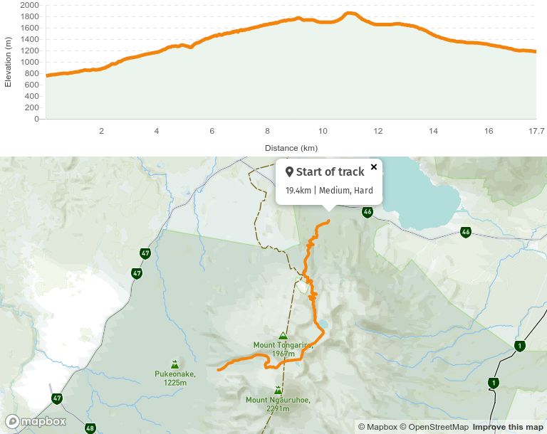
Tongariro Alpine Crossing Walking Dif culties Medium , Hard Length 19.4 km Journey Time 7 - 8 hours one way (allow full day) Region Manawatū-Whanganui Sub-Region Ruapehu Part of Collections Department of Conservation Day Hikes , Te Araroa - New Zealand's Trail , Te Araroa - North Island , Te Araroa highlights Track maintained by
y
Te Araroa Trail Trust
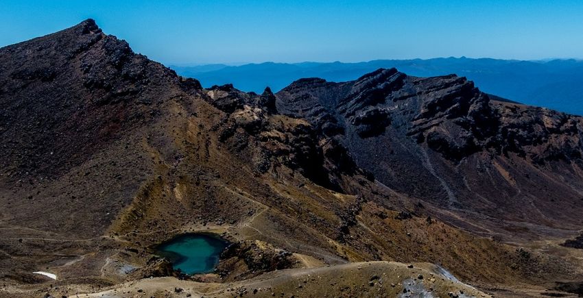
The Tongariro Alpine Crossing track passes over varied and spectacular volcanic terrain.
Trek across a volcanic alpine landscape of dramatic contrasts – steaming vents, glacial
valleys, ancient lava ows, alpine vegetation and vivid crater lakes, all with stunning
views. Be prepared for a long and challenging day out.
Tongariro National Park is a UNESCO dual World Heritage Area and was the rst in the
world to receive cultural World Heritage Status.
Description
Know before you go
Winter tramping
All waterways including the lakes on Tongariro and his peaks Ngāuruhoe and Ruapehu are
sacred to local iwi, Ngāti Hikairo ki Tongariro. Kaumātua Te Ngaehe Wanikau asks visitors
to the area to respect the sanctity of the maunga tapu (sacred mountains) by not touching
or entering any of the waterways including the alpine lakes. Ngāti Hikairo ki Tongariro
places extreme importance on their guardian role in protecting Tongariro and his peaks.
Essential gear list
Consider a compass and map (in poor visibility)
Waterproof raincoat and over-trousers
Warm woollen or polypropylene clothing
Woollen hat and mittens
Sturdy boots (sports trainers/running shoes and sandals are not suitable)
Food and drink
First aid kit
Sunscreen, sunhat and sunglasses
Note: Te Araroa track descriptions work from North to South whereas the Department of
Conservation encourages trampers to walk the Tongariro Alpine Crossing in the other
direction – from South to North. So be aware, the crossing is a very popular tramp and
following these instructions, you will be going against the tide.
Route from South to North - Te Araroa northbound - Mangatepopo to KetetahiThis challenging trip begins at 1120m. It climbs the Mangatepopo Valley to the saddle
between Mount Tongariro and Mount Ngāuruhoe, through South Crater before climbing
again to Red Crater, the highest point on the crossing at 1886m.
You will then descend on a volcanic rock scree track to the vivid Emerald Lakes, known as
Ngarotopounamu (greenstone-hued lakes). After passing Blue Lake, also known as Te Wai-
whakaata-o-te-Rangihīroa (Rangihīroa’s mirror), the track sidles around the northern slope
of Tongariro, then descends in a zigzag track past Ketetahi Shelter and down to the road
end at 760m.
Route from North to South - Te Araroa southbound - Ketetahi to Mangatepopo
From the Ketetahi Road end, the track goes through a cool podocarp-hardwood forest
which is a relaxed contrast to the coming long ascent to the Ketetahi Shelter. The track
travels alongside a stream polluted with minerals from Ketetahi Springs and, at two points,
passes over the tongue of a lava ow from Te Maari Crater.
From the forest bush line, the track winds its way up and up and up, through tussock slopes
past the Ketetahi Springs to the Ketetahi Shelter.
Note: The Ketetahi Springs are on private land. The Ketetahi Trust, representing the
landowners, has permitted trekkers to cross part of their land but this does not include
access to Ketetahi Springs. Please respect this restraint and follow the poled route.
From the Ketetahi Shelter, the track ascends further before sidling down around the anks
of North Crater to the Blue Lake and over the Mars-like Central Crater. Then it’s past the
three water- lled explosion craters called the Emerald Lakes; their brilliant greenish
colour is caused by minerals which have leached from the adjoining thermal area. The
Tongariro Northern Circuit track to Oturere Hut branches off to the left at the lowest lake.
Taking care on the loose stones and gravel on the track as you ascend steeply to the
summit of Red Crater (1886m), the highest point on the Tongariro Alpine Crossing. You can
also smell the sulphur, evidence that Red Crater is still active.
The Tongariro Alpine Crossing track then continues along a poled route down the ridge
leading to South Crater.
Note: Department of Conservation advises walkers to stay on marked tracks and not
attempt to climb the summits of Mt Ngāuruhoe and Mt Tongariro. The mountains are
sacred to local Māori tribes and they respectfully ask that summits are not climbed.From Mangatepopo Saddle between Mount’s Ngāuruhoe and Tongariro, you can be rewarded, on a clear day, by views of Mt Taranaki to the west. Then it’s a steep descent (down the Devil’s Staircase) to the head of the Mangatepopo Valley where a short side track leads to Soda Springs. The track then makes its way down the Mangatepopo Valley, at a gentle gradient alongside a stream and around the edges of old lava ows. For Te Araroa through walkers, the turnoff to the Mangatepopo Track to Whakapapa is 200m further on from the Mangatepopo Hut sidetrack. The carpark at Mangatepopo Road is 1km (15 minutes) from the Mangatepopo Track turnoff. Winter Conditions You need to be skilled and prepared to complete the Tongariro Alpine Crossing, especially during winter. An ice axe and crampons are essential, as is competency using them. What to bring Ice axe and crampons (and know how to use them) Snow gaiters Avalanche probe/snow shovel in winter Avalanche transceiver How to tramp the Tongariro Alpine Crossing in winter
Conditions:

You will need to be skilled and prepared to complete the Tongariro Alpine
Crossing, Northern Circuit and Round the Mountain tracks in winter. An ice axe and
crampons are essential, as is competency using them.

Potential hazards
     Always check the weather forecast and take local advice as weather can change
     quickly and drastically
     Always carry extra warm, wind-proof clothing, safety and navigational equipment
     Pole route markers may be dif cult to see in foggy conditions.
     Water from the upper Mangatepopo stream, Emerald Lakes and Ketetahi Springs
     is not suitable for drinking due to the high mineral content. Treat ALL water in the
     park.
     Winter tramping: Be fully equipped with ice axe, crampons, avalanche
     probe/snow shovel/transceiver.
     From the beginning of 26 October (Labour Day weekend) to 30 April, parking
     restrictions (4 hour maximum) are in place at the road-ends - book a shuttle.
     Over winter, additional hazards are present:
             Snow and ice
             Avalanche risk
             Sub-zero temperatures.

No dogs, horses, guns or bikes. No drones.

How to tramp in winter: Tongariro Alpine Crossing | Tongariro Northern Circuit | Round
the Mountain Track
How to get here
The nearest towns are:
Whakapapa (10.4 km)
National Park (13.5 km)
Turangi (36.7 km)
Raetihi (47.6 km)
Ohakune (48 km)
Taumarunui (61.5 km)
Taupō (86.5 km)
There is very limited parking near the access points to the track. From the beginning of 26
October (Labour Day weekend) to 30 April, parking restrictions (4 hour maximum) are in
place at the road-ends.
Excellent shuttle services run from all local towns - arrange through the following i-SITEs:
Whakapapa i-SITE +64 7 892 3075, State Highway 48, Whakapapa Village
Turangi i-SITE 0800 288 726, Ngawaka Place, Turangi
Ohakune i-SITE 0800 647 483, 54 Clyde Street, Ohakune
Taumarunui i-Site 07 895 7494, Railway Station, Taumarunui
Taupo i-SITE 0800 525 382, 30 Tongariro Street, Taupo
Getting to/from the start
The Whanganui region starts at the carpark at the northern end of the Tongariro Alpine
Crossing, 1km off SH 46, Tongariro National Park.
InterCity - P: 09 583 5780 - E: info@intercity.co.nz
Kiwi Experience - P: 09 336 4288 - Hop-on, Hop-off bus tours
Getting back from the end
The Whanganui section of Te Araroa ends at Bulls. It is on Highway 1 so is well serviced by
long haul buses, as above.Track Elevation and Map More information Te Araroa Manawatū-Whanganui trail notes, including information about accommodation transport and resupplying Map 56
Page last updated: Oct 28, 2021, 4:51 PM
You can also read