Tunnel Reconstruction - NYC.gov
←
→
Page content transcription
If your browser does not render page correctly, please read the page content below
Tunnel Reconstruction
Reconstructing the   Tunnel

                              2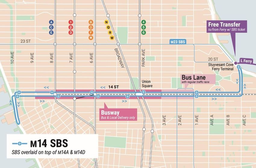
Service During Tunnel Reconstruction
      April 2019 through July 2020

                                       3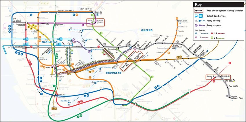
Projected Cross River Travel Paths of          Customers

                                The Service Plan:
                                Our modeling assumes 100% of
                                trips will be accommodated by one
                                of the following service options

                                                                    4
Projected Cross River Travel Paths of          Customers

                                By Subway:
                               More        service
                                  •   32% of    customers
                                  •   14% capacity increase,
                                      accommodating an
                                      additional 3,480 riders

                                                                5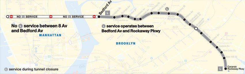
Projected Cross River Travel Paths of             Customers

                                By Subway:
                               More     service and longer trains to/from
                               Long Island City
                                   •   28% of     customers
                                   •   176% capacity increase,
                                       accommodating an additional
                                       11,100 riders

                               More   service and longer trains to/from
                               Downtown Brooklyn
                                   •   7% of     customers
                                   •   121% capacity increase,
                                       accommodating an additional
                                       7,620 riders                         6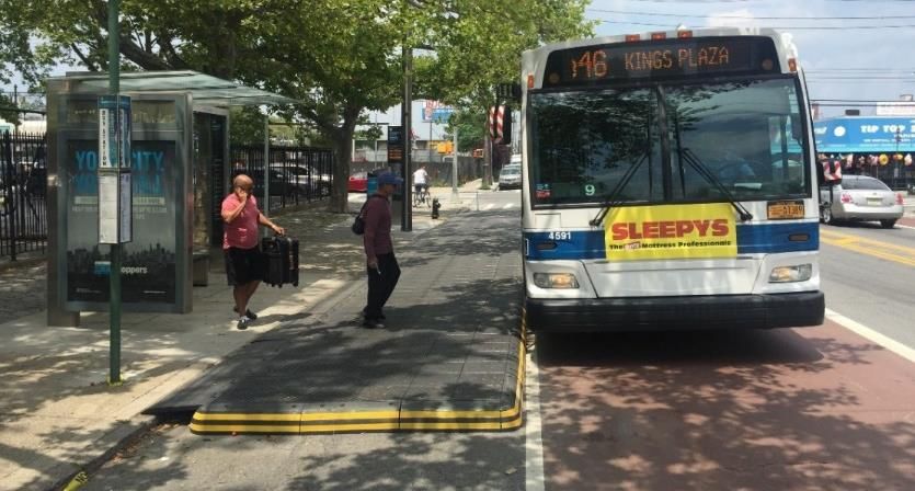
Projected Cross River Travel Paths of            Customers

                                By Subway:
                                From the   in Queens:
                                • Additional       service
                                    • 11% of      customers
                                    • 11% capacity increase,
                                       accommodating an additional
                                       3,480 riders
                                •   Additional   service
                                    • 15% of       customers
                                    • 7% capacity increase,
                                        accommodating an additional
                                        2,420 riders

                                                                      7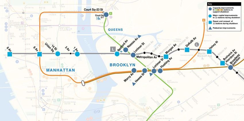
Projected Cross River Travel Paths of             Customers

                                By Subway:
                                      in Brooklyn (longer   trains)
                                  •     12% will transfer from the
                                          and
                                  •     7% capacity increase,
                                        accommodating 2,320 customers

                                                                        8
Projected Cross River Travel Paths of            Customers

                                By Subway:
                                3% of riders will take
                                the

                                                         9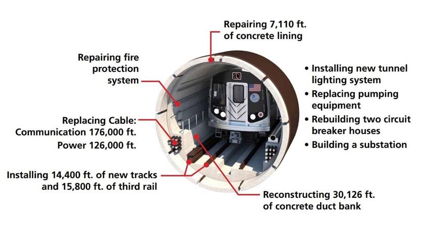
Projected Cross River Travel Paths of            Customers

                                By Bus and Ferry:
                                Four interborough Select Bus Service
                                Routes
                                    • 17% of      customers
                                    • 80 buses per hour,
                                        accommodating 4,200 riders
                                New ferry service
                                   • 4% of        customers
                                   • Eight ferries per hour,
                                       accommodating 1,190 riders

                                                                       10
Projected Cross River Travel Paths of Customers
In Summary:
• 79% of riders will take other
subway lines
• 17% of riders will take
interborough buses
• 4% of riders will take the ferry
• 71% of riders will have no more
than 10 minutes additional travel
time in AM peak
11Permanent Station Improvements
Prior to the tunnel closure, we are improving access to and capacity in stations along the
, , and lines, that will provide alternatives to service. During the tunnel
closure, we will also enhance stations along the line.
1214 St-Union Sq Station Permanent Improvements
We are improving and expanding stair circulation between the line platform and the
platforms at Union Square, and adding an escalator between the mezzanine and
platform.
BROADWAY LINE (ABOVE)
Reconstruct east
walls and roof slab
along Broadway
Line
P
5
AREA OF WORK P New 7’
8 Stairs
P
7 P
6
13Interborough Select Bus Service
80 Buses Per AM Peak Hour will Travel Across the Williamsburg Bridge
• L1 SBS
• L2 SBS
• L3 SBS
• L4 SBS
14Interborough Select Bus Service: L1 SBS
Service between
Grand St and 1 Ave/15 St:
• Every 2½ minutes
during AM peak hours
• Every 3½ minutes
during PM peak hours
15Interborough Select Bus Service: L2 SBS
Service between
Grand St and SoHo:
• Every 2½ minutes
during AM peak hours
• Every 3½ minutes
during PM peak hours
16Interborough Select Bus Service: L3 SBS
Service between
Bedford Av and SoHo:
• Every 2½ minutes
during AM and PM
peak hours
17Interborough Select Bus Service: L4 SBS
Service between
Bedford Av and
1 Ave/15 St:
• Every 6 minutes
during AM peak hours
• Every 6½ minutes
during PM peak hours
18Late Night Bus Service: L14 SBS
19Bus Priority Plan
20L2 & L3 SBS Bus Stops – SOHO/ Little Italy Loop
21L1, L2, L3 & L4 SBS Bus Stops – Delancey Street/ Essex Street
22Williamsburg Bridge HOV 3+ Hours
HOV 3+ Policy:
5 AM to 10 PM, every day Current Williamsburg Bridge Traffic Volume & Speed
• Buses, Trucks & HOV 3+ Only 40 3,000
• Manhattan- and Brooklyn-Bound 35 HOV 3+ IN EFFECT 2,500
• All Lanes
Current taxi Speed (mph)
30
Vehicles per Hour
2,000
Key benefits 25
• 5 AM start discourages early morning 20 1,500
congestion before regulation goes 15
1,000
into effect 10
• HOV supports period of highest 5
500
projected bus ridership demand
0 -
• Weekend and evening HOV hours
support non-commute trips
HOURS
DOT coordinating with NYPD on
Traffic Volume Current Taxi Speed
enforcement staging, strategy 23Interborough Buses in Soho/Little Italy Loop
• MTA adding L4 route reduces peak bus
frequency on SoHo/Little Italy loop by 13% Buses per Hour in
Soho/Little Italy Loop
• Slow or unreliable bus service would cause
people to take car or taxi trips and increase AM Peak 48
traffic congestion PM Peak 39
• HOV3 restriction on the Williamsburg Bridge is Midday/Nights 14-25
expected to reduce traffic along corridor by up Overnight 3
to 75%
24Delancey Street
• Continues bus priority from
From Williamsburg Bridge to Bowery Williamsburg Bridge
• All shuttle buses will stop at
Essex St for Delancey/Essex
F/J/M subway transfer
• Bus stops will be located on both
sides of Essex St in both
directions
• Provides a safe bike facility
connecting the Williamsburg
Bridge, Allen Street and Chrystie
Street
• Bike lane approved by CB 3 and
will be implemented in summer
• Ongoing analysis of traffic and
curb regulations
25Allen Street
From Delancey Street to Houston
• Maintains the existing
bike lanes
• Southbound bus lane will
be aligned to the left to
accommodate left-turning
buses at Delancey St (left
turns for buses only)
• M15SBS/Local will be
able to use the bus lanes
26Kenmare Street
• Kenmare is a challenging street
• Narrow street continuation of wide arterial
(Delancey St)
• High level of curb loading on several blocks
• MTA/DOT performed a traffic analysis of
Kenmare and surrounding streets
• DOT conducted merchant surveys of
businesses throughout Soho Loop
27Kenmare Street Traffic
• Most vehicles on Kenmare St are going to or coming from the
Williamsburg Bridge 25%
44%
• Around 35% of vehicles on Kenmare St are traveling to/from the Holland
Tunnel
• Westbound traffic volumes are higher than Eastbound volumes all hours
of the day 75%
• WB: 760 AM Peak, 750 PM Peak, 630 Sat. Peak 66%
• EB: 420 AM Peak, 615 PM Peak, 570 Sat. Peak
• Trucks make up approximately 10% of vehicles on Kenmare St
• During the L closure, the Williamsburg Bridge will be HOV3+ and truck Eastbound Westbound
only from 5am to 10pm 7 days a week Local Traffic
• Modeling predicts HOV3 policy will reduce traffic volumes on To/From Williamsburg Bridge
Kenmare St up to 75%
28Option A
• Shifts existing travel lanes to accommodate an
offset bus lane
• Full-time loading/parking in 8’ lane on the north
curb (currently a part time loading lane)
• Convert lane against the south curb to
Eastbound travel lane
• Eastbound through traffic would be constrained
by any loading activity on south curb
• Right turns onto and off of Kenmare would be
constrained and require stop bars to be set
back significantly
• Traffic analysis indicates this option is feasible
29Option B
• Convert Kenmare to one-way westbound from
Bowery to Lafayette St
• Add an offset bus lane
• Maintains wide loading/parking lanes
• Provides more curb loading space than the two-
way option and existing configuration
• Wider lanes would reduce traffic and bus
blockages due to double-parking
• Eastbound traffic would be diverted to other
streets
• Better accommodates the direction of travel
with the highest traffic volumes
30Comparing the Options
Option A Option B
• Maintains bi-direction traffic • Increases curbside loading over existing
• Reduces amount of curb loading/parking • Wider lanes would reduce blockages and
• Narrow loading lane may lead to bus blockages improve turns
• Curbside travel lane would be blocked by drop- • One-way traffic reduces vehicle conflicts
offs and pick-ups
• Eastbound traffic would divert to other
• Lane configuration creates more-difficult turns streets
31Kenmare at Petrosino Sq
• Westbound vehicles drive the wrong way to bypass queue making
EXISTING left turn from Kenmare St onto Lafayette St
• In response to community concerns, DOT proposes to convert
the short block of Kenmare at Petrosino Sq to one-way westbound
• Low-volume left turn from Lafayette St onto Kenmare St would be
banned
• Eliminates wrong-way movements and add pedestrian space next
to Petrosino Sq
PROPOSED
• Shortens pedestrian crossings
• Feasible with either of the broader Kenmare designs (Option A
and Option B)
• Traffic analysis indicates this change would not significantly
increase delay
32Houston Street
from Lafayette Street to Mott Street
• L2 and L3 buses will make their first pick-up stop on
Houston St between Mulberry St and Mott St
EXISTING
• Bus boarder will be installed to provide more space
for pedestrians boarding the bus
• Painted pedestrian space will be added around
subway entrance on Houston St between Lafayette
St and Mulberry St
PROPOSED
Bus Stop14th Street Transit Corridor
34M14 SBS Bus Stops – 10th Ave & Stuyvesant Cove
3514th Street Busway Hours
5 AM to 10 PM, every day
• Buses
• Emergency Vehicles Current 14th Street Traffic Volume and Speed
• Local access for deliveries, private 9 600
parking garages, pickups and drop- 8
BUSWAY IN EFFECT
offs 7
500
Vehicles per Hour
Bus Speed (mph)
6 400
• Busway hours support period of highest
5
traffic demand on 14th Street 300
4
• Bus lane camera enforcement and
3 200
NYPD presence will deter through traffic
• Busway operation without a midday gap 2
100
allows for clear messaging and 1
enforcement 0 0
• DOT will monitor traffic conditions on
14th Street and wider traffic network
Traffic Volume Current M14 Speed
throughout the closure period
3614th Street Busway Design
Existing
Proposed (at stops)
Proposed (midblock)
37Pedestrian Volume Increases
Pedestrian surges of over 2x existing volumes on a Vision Zero
Priority Corridor W 14th Street at Sixth Avenue
14th Street Projected Pedestrian Volume Changes
8-9 AM Peak Hour
Location Existing Volume New Volume % changes
Union Sq
(4 Av, Union Square East,
Broadway, University Pl, Union
Square West) 7,500 11,500 53%
6 Av 3,100 7,400 139%
W 34th Street at Sixth Avenue
8 Av 1,700 3,000 76%
14th St Projected Existing 34th St Existing 42nd St
Location Volume Volume Volume
6 Av 7,400 8,000 9,100
Data Inputs: counts of current pedestrians, projected bus volumes, projected
entrance and exit of subway stations by stairway 38Busway between 5th and 6th Avenue
Commercial Loading, Parking
Garage & Local Access
Pedestrian Area
Shorter Ped Crossing
M14 Local
M14SBS/Local
Commercial Loading
& Local Access Bus Passing Lane
Bus BoarderLocal Access within the 14th Street Busway
Local Access/Loading
Local Access/Loading
Bus Lane
N Camera
• Response to public and elected official • Most pickup/dropoff activity currently takes
feedback place on the avenues, not on 14th Street
• Local Access: • DOT will conduct outreach local businesses
• Turn right on to 14th Street and residents about access policy
• Exit at next right turn
• Left turns prohibited at most intersections
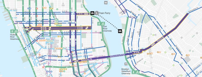
• Enforceable with bus lane cameras 4040Bicycle Network Connections
2,000 – 3,500 cyclists projected
to cross the Williamsburg Bridge
during AM rush hour (8A-9A)
4112th St & 13th Street Bike Lanes
Background
Original Design Typical: 13th St Two-Way Path
Example: Clinton St, MN
Existing: Wide travel lane Proposed: Two-way bike path
Alternate Design Typical: 12th St & 13th St One-Way Pair Example: Bleeker St, MN
Existing: Wide travel lane Proposed: One-way bike lane12th St & 13th Street Bike Lanes
Route Details
Existing Condition: Wide travel lane Proposed Configuration: Curbside bike lane on left Design Details
Blocks range from 29’-34’ wide side (south side of 13th St, north side of 12th St) • Bike lane separated with flexible
delineators and demarcated buffer
• Floating pickup & drop-off adjacent to bike
lane may be feasible at some locations
• Parking spaces to be removed along
• North side of 12th St (7th Ave – Ave C)
• South side of 13th St (Greenwich Ave – Ave B)
Project MapCiti Bike Infill
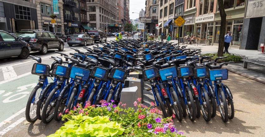
Increasing docks and bikes in the existing service area
• 1,250 bikes, 2,500 docks
• Manhattan: 59th Street – Canal
• Brooklyn: Williamsburg area
• Expanded Valet Services
• Staffed by Citi Bike, Valet Service allows
Stations to operate at increased capacity
• Pedal-assist Shuttle Service
• 1,000 pedal assist bikes
• Available at key locations
• 2 in Manhattan
• 2 in Brooklyn
• Additional standard bike parking in key locationsUnion Square West and University Place
Green Market
Realignment New Curb Improve Accessibility
Regulations and bike connection
EXPANDED ‘SERVICE EXPANDED SHARED
PUBLIC SPACE LOOP’ PUBLIC SPACE STREET
• Reduce pedestrian congestion • Maintain circulation for • Improve pedestrian circulation • Expand bike parking options
Deliveries, Pick-up/ drop-off, Ex: CitiBike Valet Service,
• Strengthen SB bike connection Farmers Market trucks • Strengthen SB bike connection Racks, Secure Bike Parking 45Initiating Proposed Ferry Service
Ferry Will Operate 6 AM to Midnight on Weekdays, and 6 AM to 2 AM on Weekends
Between Brooklyn
and Manhattan:
• Every 7½ minutes
during AM and PM
peak hours
• Every 10 minutes
middays, evenings
and weekends
46Weekend Preparatory Work on Line
• Ensure reliable service for riders
during reconstruction
• Ensure project duration stays within
15 months
• No service between Manhattan
and either Myrtle-Wyckoff Avs or
Broadway Junction
47Customer Service and Communications
Remaining Responsive:
• Hundreds of MTA staff will be deployed at subway stations, bus
stops and ferry locations to manage crowding to ensure safety
• Actively communicate with customers in real time, in person and
through all available channels
• MTA to work with DOT and other relevant City agencies to
ensure responsive information dissemination and feedback
• Will make adjustments to the plan in response to feedback
48Proposed Alternate Subway, Bus and Ferry Services
49You can also read


