UAV application to estimate oil palm trees health using Visible Atmospherically Resistant Index VARI Case study of Cikabayan Research Farm ...
←
→
Page content transcription
If your browser does not render page correctly, please read the page content below
E3S Web of Conferences 211, 05001 (2020)                                 https://doi.org/10.1051/e3sconf/202021105001
The 1st JESSD Symposium 2020

       UAV application to estimate oil palm trees health
       using Visible Atmospherically Resistant Index
       (VARI) (Case study of Cikabayan Research Farm,
       Bogor City)
       Medina Nur Anisa1, Rokhmatuloh1*, and Revi Hernina1
       1Department of Geography, Faculty of Mathematics and Natural Science, Universitas Indonesia,
        Depok, 16424, Indonesia

                     Abstract. This article describes the making of an oil palm tree health map
                     using aerial photos extracted from UAV DJI Phantom 4. A DJI Phantom 4
                     was flown at 100 meters height at the Cikabayan Research Farm, Bogor
                     City. Raw aerial photos from DJI Phantom 4 were processed using Agisoft
                     Photoscan software to generate dense point clouds. These points were
                     computed to produce a digital surface model (DSM) and orthophotos with a
                     spatial resolution of 2.73 cm/pixel. Red, green, and blue bands of the photos
                     were computed to provide the Visible Atmospherically Resistant Index
                     (VARI). Also, orthophotos containing oil palm trees were digitized to create
                     points in vector form. VARI pixel values were added to each point and
                     classified into four classes: Needs Inspection, Declining Health, Moderately
                     health, and Healthy. Resulted oil palm tree health map reveals that most of
                     the oil palm trees in the study location are classified as Declining Health and
                     Needs Inspection. Profitably, plantation workers can directly inspect oil
                     palm trees whose health are declining, based on information derived from
                     oil palm tree health map. The information that comes from this study will
                     significantly save time and effort in monitoring oil palm trees' healthiness.

       1 Introduction
       The development of oil palm plantations is a strategic issue that encourages and improves
       the community's welfare, the national economy, and makes Indonesia the largest producer of
       palm oil [1]. It is envisaged that the development of oil palm plantations can open up business
       opportunities and increase employment. With this development, it is not surprising that the
       Indonesian palm oil industry has become a topic of interest to the world community.
            Trees maintenance is crucial to determine whether the plants are healthy or sick to
       increase oil palm plantations. Plants with the disease will be treated or replaced with new
       plants to increase oil palm production. Monitoring oil palm plantations traditionally will
       require a lot of time and effort. Therefore cheaper and more efficient technological
       innovations are needed.

       *   Corresponding author: rokhmatuloh.ssi@sci.ui.ac.id

© The Authors, published by EDP Sciences. This is an open access article distributed under the terms of the Creative Commons
Attribution License 4.0 (http://creativecommons.org/licenses/by/4.0/).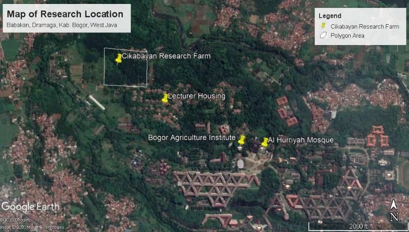
E3S Web of Conferences 211, 05001 (2020)                      https://doi.org/10.1051/e3sconf/202021105001
The 1st JESSD Symposium 2020

           Unmanned Aerial Vehicles (UAV) or Drone mapping technology is an alternative option
      besides other mapping technologies such as large and manned aerial photography and
      satellite-based mapping. UAV is a type of aircraft controlled by a remote control system tool
      via radio waves. The UAV is an electro-mechanical-based system that can carry out
      programmed missions with the characteristics of a flying machine that functions remotely by
      the pilot or can control himself, using aerodynamics' laws to lift himself [2].
           UAV technology can be used to estimate vegetation cover [3], monitoring forest
      rehabilitation [4], forest fires [5], and monitoring forest health [6]. The drone has many
      advantages when compared to other remote sensing platforms such as planes and satellites.
      These advantages include cloud-free images and higher spatial resolution. UAV technology
      has the potential to be used for particular mapping purposes in agriculture [7]. Considering
      all the benefits mentioned earlier and the advantages of UAVs, this study uses UAVs' ability
      to monitor the health of oil palm trees. Not to mention that UAV applications can save time
      and increase productivity. Therefore, this study aims to estimate oil palm trees' health using
      the Visible Atmospheric Resistant Index (VARI) by utilizing aerial mapping technology.

      2 Method
      In this study, the oil palm plantations will be monitored using visible wavelengths generated
      from Unmanned Aerial Vehicles (UAV). The visible wavelengths were processed to generate
      the Visible Atmospherically Resistant Index (VARI), which would be used as a health
      indicator of oil palm trees.

      2.1 Research locations

      Cikabayan Research Farm is located at 6°33'5.06"S and 106°43'3.78"E. It is relatively close
      to the IPB University campus, close to the housing for lecturers (Figure 1). When seen in
      Figure 1, Cikabayan Research Farm is located north of the IPB University campus. This
      research farm has the largest area when compared to other research farms. Cikabayan
      Research Farm has around 22 hectares with a significant land area of approximately 5
      hectares.

      Fig. 1. Map of Research Location (Cikabayan Research Farm). (source: Google Earth)

                                                   2
E3S Web of Conferences 211, 05001 (2020)                     https://doi.org/10.1051/e3sconf/202021105001
The 1st JESSD Symposium 2020

      2.2 Field data

      In recording field data using a rotor type UAV [8], a DJI Phantom 4 was flown in the study
      area (Figure 2). Before recording, a flight path was planned using the Pic 4D application on
      the mobile phone (Figure 3). This recording time took 9 minutes with a flying altitude of 100
      meters above ground to get detailed and precise data with a spatial resolution of 2.73
      cm/pixel.

      Fig. 2. DJI Phantom 4. (Personal Data)

      Fig. 3. Flightpath mission planning on Pic 4D mobile application. (Data Processing)

      2.3 Data processing
      After the recording phase, a JPEG format photo was obtained equipped with geographic
      coordinates. Approximately 80 photos were acquired from the UAV flight and combined
      using a photo mosaic process in the Agisoft Photoscan software. Combined photos were
      aligned to create dense point clouds. These points were calibrated to generate a mesh that
      provided a digital surface model (DSM) [9] and orthophotos. Orthophotos were converted
      into a tiff file extension using ArcGIS Pro software.

                                                   3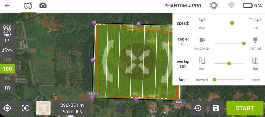
E3S Web of Conferences 211, 05001 (2020)                        https://doi.org/10.1051/e3sconf/202021105001
The 1st JESSD Symposium 2020

      Fig. 4. The orthophoto in .tiff file. (Data Processing)

      2.4 Digitizing oil palm trees
      The orthophoto was digitized using ArcGIS Pro software to create and manage label objects
      [10]. All oil palm trees were digitized to generate circular polygons based on the size, shape,
      and characteristics extracted from aerial photographs. Next, digitized polygons were
      extracted into points and saved.

      Fig. 5. Digitized polygons of all oil palm trees. (Data Processing)

      2.5 Raster processing

      After the digitization process was completed, the next process was to estimate oil palm trees'
      health using VARI. VARI is an indirect measure developed from the Leaf Area Index (LAI)
      and Vegetation Fraction (VF) based on visible wavelengths' reflectance values. VARI can be
      calculated using the following formula:

                                VARI = (Rg - Rr) / (Rg + Rr - R(Rg - Rb))

                                                     4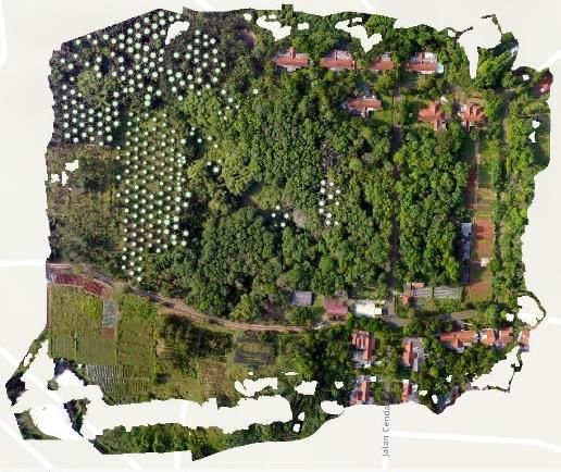
E3S Web of Conferences 211, 05001 (2020) https://doi.org/10.1051/e3sconf/202021105001
The 1st JESSD Symposium 2020
Rr, Rg, and Rb reflect values for the red, green, and blue bands, respectively [11].
Fig. 6. Map with VARI pixel values. (Data Processing)
A raster function containing band arithmetic was used to display the map resulted from VARI
computation. Parameters containing the VARI method were selected in the analysis step.
When the parameter index shows red, green, and blue bands, fill in the index band with 1 for
red, 2 for green, and 3 for blue. The standard deviation menu was chosen to increase the
sharpness of the stretched image.
A raster map showing VARI was beneficial but could not be used to determine which
trees need maintenance. Hence, it was necessary to have the average VARI value for each
tree by extracting the VARI raster map using circular polygons. It could finally show healthy
trees and which trees needed treatment.
3 Results and discussion
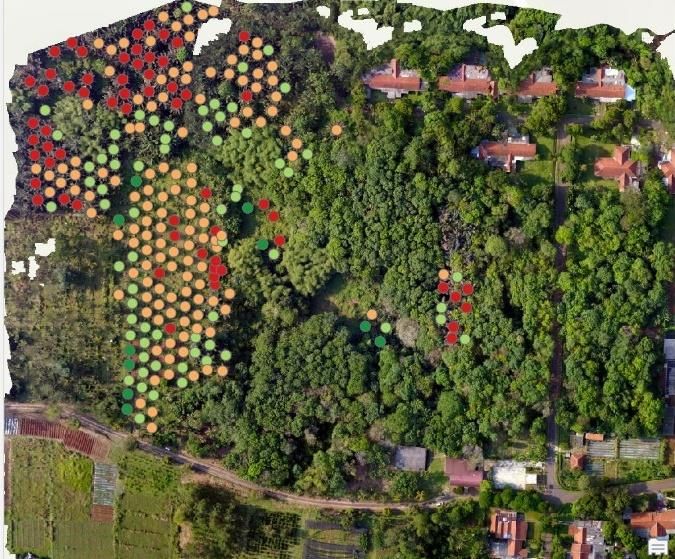
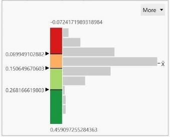
Resulted from VARI values are divided into four classes: Needs Inspection, Declining
Health, Moderately health, and Healthy. Furthermore, each class is symbolized by gradation
colors (red-yellow-green) to differentiate healthy trees from trees that need maintenance
(Figure 8). The resulting oil palm tree health map in the Cikabayan Research Farm reveals
that most oil palm trees are in Declining Health and Needs Inspection. Plantation workers
can directly inspect oil palm trees whose health is declining, based on information derived
from oil palm tree health map. The information that comes from this study will significantly
save time and effort in monitoring oil palm trees' health.
Fig. 7. The process of Vegetation Health Estimation (VARI, Extract, and Classes). (Data
Processing)
5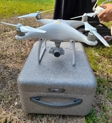
E3S Web of Conferences 211, 05001 (2020)                        https://doi.org/10.1051/e3sconf/202021105001
The 1st JESSD Symposium 2020

      Fig. 8. Oil palm tree health map. (Data Processing)

      4 Conclusion
      The conclusion of this research is that the health of oil palm plants can be detected by utilizing
      aerial photographic images taken with UAV DJI Phantom 4 by calculating the Visible
      Atmospherically Resistant Index (VARI). If the plant is quickly detected as unhealthy, it will
      be quickly checked. So that aerial photography technology will save time and effort in
      monitoring the health of oil palm.

      References
      1.     USDA. The Natural Resources Conservation Service 2019: The PLANTS Database
             National Plant Data Team Greensboro NC 27401-4901 (2019)
      2.     H.S. Saroinsong, V.C. Poekoel, and P.D. Manembu, Design of Unmanned Aircraft
             Vehicle Based on Ardupilot, Journal of Electrical and Computer Engineering. 7, 1
             (2018)
      3.     R.P. Breckenridge, and M. E. Dakins, Evaluation of bare ground on rangelands
             using unmanned aerial vehicles: A case study GIScience, Remote Sensing. 48, 12
             (2011)
      4.     J.N. Hird, A. Montaghi, G.J. McDermid, J. Kariyeva, B.J. Moorman, S.E. Nielsen
             and A.C.S. McIntosh, Use of unmanned aerial vehicles for monitoring recovery of
             forest vegetation on petroleum well sites, Remote Sensing. 9, 413 (2017)
      5.     V.G. Ambrosia, S.S. Wegener, D.V. Sullivan, S.W. Buechel, S.E. Dunagan, J.A.
             Brass, and S.M. Schoenung, Demonstrating UAV-acquired real-time thermal data
             over fires, Photogramm. Eng. Remote Sens. 69, 4 (2003)
      6.     J.P. Dash, M.S. Watt, G.D. Pearse, M. Heaphy, and H.S. Dungey, Assessing very
             high-resolution UAV imagery for monitoring forest health during a simulated
             disease outbreak ISPRS, Journal of Photogrammetry and Remote Sensing 131
             (2017)
      7.     C.A. Rokhmana, The Potential of UAV-based Remote Sensing for Supporting
             Precision Agriculture in Indonesia in Ist International Symposium on LAPAN-IPB
             Satellite (2014)

                                                     6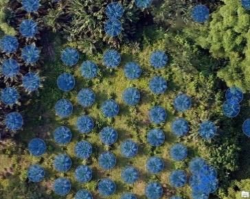
E3S Web of Conferences 211, 05001 (2020)                  https://doi.org/10.1051/e3sconf/202021105001
The 1st JESSD Symposium 2020

      8.     H.A. Afif, R. Saraswati, and R. Hernina, UAV Application for Landslide Mapping
             in Kuningan Regency, West Java in E3S Web of Conferences EDP Sciences. 125
             (2019)
      9.     A. Syetiawan, and H. Gularso, Establishment of DSM Using Unmanned Aircraft
             System (UAS) and Non-Metric Digital Cameras in the National Seminar on
             Geography and Sustainable Development. (2018)
      10.    ArcGIS Learn, https://learn.arcgis.com/
      11.    A.A. Gitelson, Y.J. Kaufman, R. Stark, and D. Rundquist Novel algorithms for
             remote estimation of vegetation fraction, Remote sensing of Environment. 80, 1
             (2002)

                                                7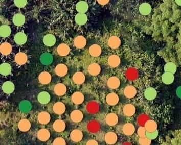
You can also read