Updated Hoveton Wetlands Restoration WFD Compliance Assessment - January 2021 Scott Hardy
←
→
Page content transcription
If your browser does not render page correctly, please read the page content below
Updated Hoveton Wetlands
Restoration WFD Compliance
        Assessment
          January 2021

           Scott Hardy
         Natural England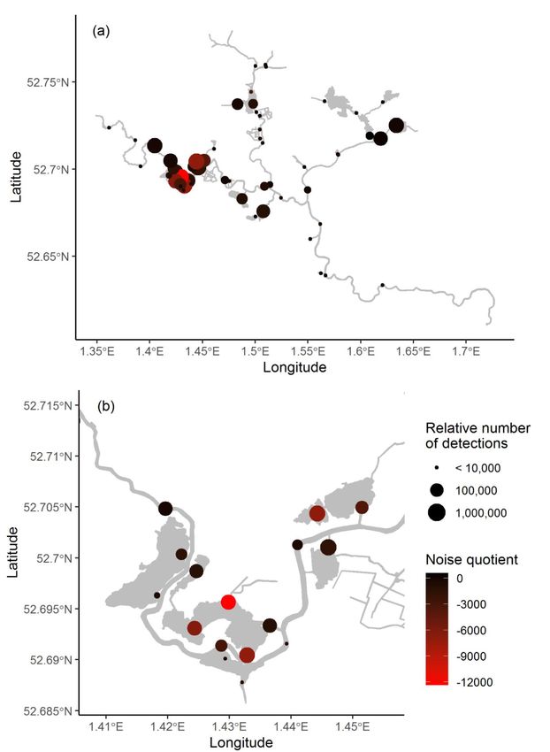
Introduction
This assessment is an update to the ‘Hoveton Wetlands Restoration WFD Compliance Assessment,
March 2014’ It replaces the ‘Updated Hoveton Wetlands Restoration WFD Compliance Assessment,
March 2020’ and the ‘Addendum to Hoveton Wetlands Restoration Project Water Framework
Directive Assessment (WFDA), January 2020’ submitted with FRAP application EPR/NB3494JP. It
provides a concise update using the most recent WFD condition monitoring and reviews the
conclusions of the 2014 assessment. It should be read in conjunction with the ‘Hoveton Wetlands
Restoration WFD Compliance Assessment, March 2014’ (submitted with FRAP application). The
sediment removal works associate with the project have been completed. This updated assessment
therefore focuses on the WFD impact of the biomanipulation of Hoveton Great Broad and Hudson’s
Bay, namely:
• The installation of fish barriers on Hoveton Great Broad.
• Biomanipulation - the removal of >75% of the fish biomass from Hoveton Great Broad and
Hudson’s Bay.
• Releasing the removed fish on the River Bure.
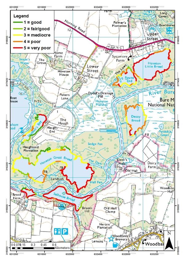
Hoveton Great Broad Restoration Project update
The project has just completed the process of sediment removal and the establishment of fen
vegetation areas. Sediment was dredged from the broad to a depth of 1.1m and used to fill geo-
textile bags to create new vegetation areas. Additional sediment was then taken to back fill the
northern and western sites only. Fen vegetation was taken from Woodbastwick marshes, adjacent
to decoy broad, to help establish these new fen areas. Early signs of growth seen on these areas is
encouraging.
The next phase of the project is to isolate Hoveton Great Broad from the river Bure and adjacent
marsh dykes. This will be achieved with the installation of 3 water permeable barriers within
Hoveton Great Broad at Foxborrow Dyke (TG32071581), The Dam (TG32421614), and Hoveton
Marshes (TG31891651). These barriers will prevent movement of fish but maintain hydrological
connectivity between to the river. In addition two small scale non-permeable barriers have been
installed at Gravel Dyke (TG31403159) and Hudson's Marsh Dyke (TG31631687 – also known as
Haugh’s End Dyke).
Biomanipulation will then involve the removal of >75% of the fish biomass focusing on
zooplanktivorous and benthivorous fish species. This should provide conditions for the clear-water
state to be recreated and in turn allow macrophytes to re-establish. Once a diverse and abundant
macrophyte community has been achieved it is anticipated the broad will maintain a stable clear
water, macrophyte dominated state, and the barriers will be removed.
Simultaneously, the project continues to maintain and develop the Hoveton Great Broad Nature
Trail, seeing a year on year growth of visitor numbers of around 10% a year. The project also delivers
an extensive engagement and community outreach programme which worked with 3000 people last
year across 55 events.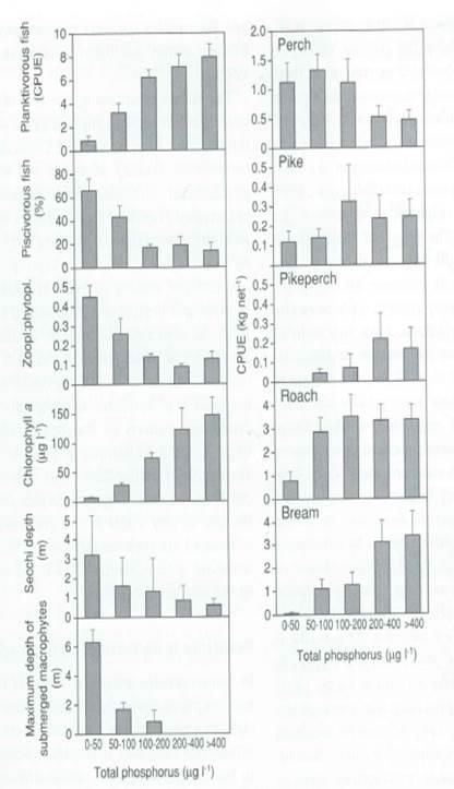
WFD assessment
The following section considers the change in WFD condition since the 2014 assessment and reviews
the conclusions of the 2014 assessment considering the most up to date information available. The
project will no longer be undertaking the proposed marginal habitat works at Wroxham Broad
therefore Wroxham Broad has not been included in this updated analysis. In addition sediment
removal and creation of the new fen areas on Hoveton Great Broad has been completed, therefore
this update assessment will focus on the isolation of Hoveton Great Broad from the system, via the
installation of fish barriers, the removal of fish as part of the biomanipulation, and the introduction
of those removed fish in to the River Bure.

Hoveton Great Broad (waterbody ID: GB30535977)
Key activities to be assessed for Hoveton Great Broad:
•      Broad isolation and fish removal

Table 1. Selected WFD data for Hoveton Great Broad waterbody. Quality elements are italicised, statuses are in
bold and failing elements are in red and passing elements in green.

   Hoveton Great Broad
                                                                    waterbody ID: GB30535977

   Waterbody size:                                                             0.37km

   Typology:                                                        High Alkalinity, Very Shallow
   Hydromorphology designation:                              not designated artificial or heavily modified

                                       2014 classification                2016 classification                2019 classification
   Overall Water Body:                   Moderate                              Poor                               Poor

   Biological Status:                    Moderate                              Poor                               Poor

   Macrophytes:                          Moderate                              Poor                               Poor
   Phytoplankton Blooms:                    Poor                                Poor                              Poor
   Fish                                 Not assessed                       Not assessed                      Not assessed

   Physio-chemical Status:               Moderate                           Moderate                           Moderate

   Dissolved Oxygen:                        High                                High                          Not assessed
   Total Phosphorous:                    Moderate                           Moderate                           Moderate
   Total Nitrogen                       Not assessed                       Not assessed                           Poor

   Morphology Status:                      Good                                Good                               Good

   Hydrology:                               High                                High                              High
   Morphology:                             Good                                Good                               Good

   Chemical Status:                Assessment not required           Assessment not required                       Fail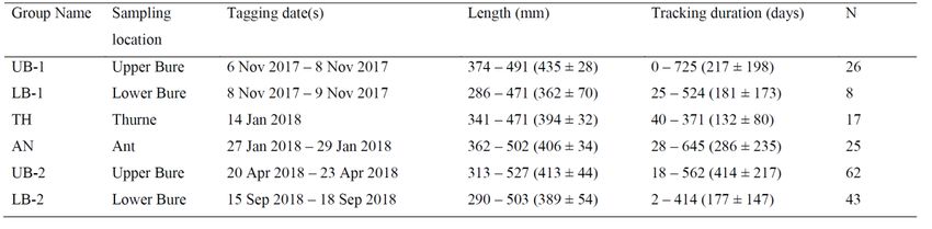
Flouranthene:                       Not assessed              Not assessed                Good
  Priority Hazardous substances:      Not assessed              Not assessed                 Fail

Hoveton Great Broad (HGB) (waterbody ID: GB30535977) consists of HGB itself as well as the smaller
broad Hudson’s Bay. It is connected to the River Bure (waterbody ID: GB105034050930) at various
points where water exchange occurs. Water from the Hoveton Marshes also drains into this
waterbody but many of the dykes on the marsh are silted up and the marshes themselves are
scrubbing over. At the northern end of Hudson’s Bay is an area of marsh/wet woodland with a
shallow dyke system which connects to the River Bure.

Macrophytes – Poor
Since the 2014 assessment macrophytes have deteriorated from moderate to poor despite
improvements in the WFD status of macrophytes within the River Bure. This decline occurred before
the first round of sediment removal in August 2016 so is due to natural deterioration of the water
body. This decline is likely to be a consequence of continued high turbidity within Hoveton Great
Broad associated with high algal concentration. Other mechanisms could include sediment
suspension through wind action or benthivorous fish feeding, and reduced grazing by zooplankton
due to high numbers of zooplanktivores.

The installation of fish barriers and biomanipulation of Hoveton Great Broad and Hudson’s Bay will
help improve conditions for macrophyte growth and recovery by removing zooplanktivores to
reduce predation on zooplankton and therefore increase grazing on phytoplankton, reduce
sediment suspension and uprooting of macrophytes by removal of benthivorous fish, and reduce
sedimentation from wind action as macrophytes stabilise the sediment. Any localised damage to
macrophytes during the installation of the barriers will be minimal and short-term.

There is no change from the conclusion of the 2014 WFD assessment:

‘the central aim of this project is to improve the clarity of the water in the broad which will improve
conditions for macrophyte growth. The project is using proven methods to restore the broad back to
an ecologically favourable condition of clear water with lush macrophyte growth.’

Indeed, the proposed works should deliver a significant improvement in the macrophyte WFD
element.

Phytoplankton – Poor
There has been no change in phytoplankton status since the 2014 assessment. The installation of
fish barriers is not expected to suspend significant amounts of sediment. However, if some sediment
is suspended during installation the conclusion of the original assessment still stands, with
improvements expected following biomanipulation:

‘The impact of the works will be of a temporary nature and will not impact the WFD status for
phytoplankton blooms. An increase in blooms may occur for a short time after the works but when
the lake is monitored for WFD these impacts should no longer be apparent. Phytoplankton is
monitored in the summer between July-September. In the long-term the Phytoplankton bloom status
should improve as the amount of phosphate in the waterbody will be less as a result of the sediment
removal. Also, as part of this project, fish will be removed from the broad and the broad isolated for
up to 10 years [permission for 10 years granted]. Removal of fish has been shown to reduce
chlorophyll a, a proxy for phytoplankton abundance, in shallow broads (Moss et al., 1996). Fish
predation of zooplankton can suppress zooplankton numbers so that they are no longer effectively
grazing phytoplankton. This allows phytoplankton abundance to increase thus increasing turbidity
and suppressing macrophyte growth. The removal of fish coupled with sediment removal can have
an almost immediate positive impact on water clarity and macrophyte growth (Moss et al., 1996).’

This conclusion is supported by the Broads Authority’s ‘A review of lake restoration practices and
their performance in the Broads National Park’ which reports large reduction in chlorophyll a and
corresponding increase in Secchi depth (often to the lake bed) providing ‘gin-clear’ conditions
appears to be guaranteed in biomanipulated lakes and exclosures in the Broads (Phillips et al. 2015).

Fish – not assessed
No tool is currently available to assess the WFD status of the fish communities in lakes, therefore the
Environment Agency have not assessed the fish element for HGB. Given concerns about the impact
of the proposed works on the fish community an assessment of the likely impact of the project on the
WFD status of the fish has been completed by Natural England using the best available evidence and
is included in appendix 1 of this assessment. Below provides a brief summary and those looking for
further information should consult the appendix

With regards to HGB the assessment concludes that the current fish status is poor. Monitoring data
shows a fish community within HGB is dominated by roach in number and bream by biomass. Such
communities are highly indicative of lakes suffering from eutrophication, and such fish communities
help maintain poor ecological condition with turbid waters and low macrophyte diversity and
coverage. The EA’s Scientific and Evidence Services team highlight bream as a species which can
actively increase turbidity, reduce macrophyte abundance, and impact on WFD status when in high
numbers (Bentley et al. 2014).

Whilst monitoring data indicates that HGB is an important spawning site for bream within the
Northern Broads system, the evidence is clear that the current fish community dominated by bream
and roach does not represent a fish community in ‘Good Ecological status’ (GES). Furthermore, a fish
community which helps maintain poor ecological status is not compatible with GES under the WFD.
Therefore, restoring a more diverse fish community associated with the clear water macrophyte
dominated lakes within The Broads cannot be considered a decline in the WFD status of the fish
community within Hoveton Great Broad.

The impacts of the displacement of this bream community on the WFD status at other sites within the
broads is discussed further in appendix 1 and the relevant assessments below.

Dissolved Oxygen – not assessed
There was no assessment of dissolved oxygen status in the 2019 WFD monitoring data report, and
there was no change from the 2014 assessment in the 2016 WFD monitoring data. Installation of
fish barriers is not expected to suspend significant amounts of sediment. Monitoring of Dissolved
Oxygen levels during sediment removal did not record any significant declines (i.e. danger to fish),
and effects are short-term. In addition, monthly water sampling by the project consistently shows
high dissolved oxygen levels within Hoveton Great Broad. There is no change from the conclusion of
the 2014 assessment:

‘High status is the top status under WFD and indicates that human activity is having no or limited
impact on this element. DO will only be temporarily impacted by the [works] and therefore there will
be no deterioration in the WFD status for this element.’

Total Phosphorous – Moderate
The status of total phosphorus has not changed since the 2014 assessment. Whilst the River Bure
has seen improvements in phosphorous levels these improvements have not been seen in Hoveton
Great Broad. The high levels of phosphorus in Hoveton Great Broad are attributed to in lake
nutrient cycling caused by the presence of nutrient rich sediment. In lake cycling is expected to
improve following the sediment removal over the short-term. In addition, stabilisation of the
sediment through establishment of macrophytes should further reduce in lake cycling. Increased
macrophytes are also likely to reduce phosphorous through direct absorption during growth.

There is no change to the 2014 assessment:

‘Apart from a potential short-term increase in total phosphorous the long-term impact of these
works will be to reduce total phosphorous concentrations.’

Hydrology – High
There has been no change in hydrology element since the 2014 assessment.

The fish barriers being installed on Hoveton Great Broad at Foxborrow Dyke, The Dam, and Hoveton
Marshes will be constructed from 2mm screen and permeable to water. The barriers installed at
Gravel Dyke and Hudson’s Marsh Dyke are not permeable, however their impact on the hydrology
of HGB is considered de minimis. The barrier at Gravel Dyke was put in as a precaution to ensure
that biomanipulation was not undermined by any potential connection to the River Bure. It was
installed at the site of an extinct dyke which used to connect to the river but for many years has
been silted up and scrubbed over. We have been unable to detect any flow through Gravel Dyke at
various states of the tide, but given the investment in the biomanipulation, the relatively low cost of
installing this small barrier as a precaution was considered appropriate. The dyke to the north of
Hudson’s Bay is extremely shallow and flow from this dyke into Hudson’s Bay appears minimal. At
high water levels flow into or out of Hudson’s Bay in this area is primarily across the adjacent marsh,
which is not impeded by the low profile barrier in the dyke.

Therefore the conclusion of the 2014 assessment stands:

‘No water level management works are planned for this project nor are any of the other works expected
to have an indirect affect on hydrology. No abstraction of water is planned either therefore no
deterioration in this element is to be expected.’
Morphology – Good
There has been no change in the morphology classification since the 2014 assessment. The installation
of fish barriers will not have an impact on the morphology of Hoveton Great Broad, therefore there is
no change in the conclusion of the 2014 assessment:

‘There should be no long-term deterioration of this quality element’.

Chemical Status – Fail
Reported in previous WFD status reporting as ‘not requiring assessment’, and therefore not included
in the 2014 WFD assessment, the chemical status of Hoveton Great Broad was reported as ‘fail’ in
2019. This was due to levels of Polybrominated diphenyl ethers (PBDE) most likely from diffuse
sources and waste water treatment works.

Installation of the fish barriers is not expected to suspend significant amounts of sediment which could
be a source of PBDE. In addition, long term stabilisation of the sediment through macrophyte recovery
as a result of the project is likely to reduce this potential source of PBDEs within the surface water.
Therefore, it can be concluded that there should be no long-term deterioration of this quality element
as a result of the works.

River Bure
The original 2014 assessment used the WFD classifications for River Bure (waterbody ID:
GB105034050930). This waterbody has since been divided for WFD reporting and therefore data is
no longer available for the river Bure under this waterbody ID. As such, this assessment has used
River Bure (Horstead Mill to St Benet's Abbey) (waterbody ID: GB105034050931) which represents
the section of the river Bure adjacent to Hoveton Great Broad. The 2014 values in table 2 have been
updated accordingly.

Key activities to be assessed for the River Bure:
•       Installation of fish barriers on HGB – associated suspended sediment.
•       Release of fish removed from HGB during biomanipulation.

Table 2. Selected WFD data for the River Bure waterbody. Quality elements are italicised, statuses are in bold
and failing elements are in red and passing elements in green.

River Bure
                                Waterbody ID: GB105034050930            Waterbody ID: GB105034050931

 Waterbody size:
                                           54.47km                                     29.799 km

 Typology:                         Low, medium, calcareous                               River
 Hydromorphology designation:         Heavily modified                           heavily modified

                                      2014 classification        2014 classification               2019 classification
 Overall water body:                        Poor                       Good                           Moderate

 Biological Status:                         Poor                       Good                              Good
Diatoms Moderate Not assessed Not assessed Macro-invertebrates Good Good Good Macrophytes Moderate High High Fish Poor Not assessed Not assessed Physio-chemical Status: High Good Moderate pH High High High Ammonia High High High Dissolved Oxygen: High Good Moderate Phosphate High High High Morphology Status: Moderate Good Good Hydrology: Moderate Good Good Morphology Moderate Not assessed Not assessed Chemical Status: Good Good Fail The following assessment reviews the conclusions of the original WFD assessment (submitted with FRAP application) considering the new WFD waterbody boundaries and their changed condition status. Diatoms – not assessed Diatoms have not been assessed as part of the new waterbody (Waterbody ID: GB105034050931). As per the original assessment diatoms respond to phosphate levels. The only impact on diatoms from the project could be caused by a short-term increase in suspended sediment and available phosphate. It’s not anticipated that sediment suspension will be significant during the installation of the barriers. Any small amounts of suspended sediment released will be diluted by the flow of the River Bure and will only be temporary in nature. The mitigation measures proposed in the original assessment and conclusion are still appropriate, as below: ‘Mitigation Measures Silt curtains will be placed at points around the exit points around HGB to reduce suspended sediment flushing into the River Bure. Conclusion This project will cause no long-term deterioration for this element.’ Macrophytes - High Macrophytes have been assessed as having high status as part of the new waterbody (Waterbody ID: GB105034050931). However, this does not affect the conclusion of the original assessment, as below:
‘Long-term inputs of phosphate can impact on the macrophyte element. Any inputs of suspended
nutrients and thus phosphates into the River Bure from HGB will be small and of a temporary nature,
therefore no deterioration in this element is to be expected because of the installation of fish
barriers.‘

Macroinvertebrates - Good
There has been no change in the WFD status from the original WFD assessment. The conclusions of
the original WFD assessment stand, as below:

‘The Macroinvertebrates are good indicators of habitat quality, flow dynamics and oxygen levels, as
well as being useful indicators of acute and chronic pollution incidents. Sediment is a natural part of
a river but a small input of sediment from works on HGB may cause a localised short-term impact on
macroinvertebrates. Excessive sediment can alter the macroinvertebrate community as different
taxa have varying tolerances to sediment. However, the inputs from these works will be negligible.

Mitigation Measures
Silt curtains will be placed at points around the exit points around HGB to reduce suspended
sediment flushing into the River Bure.

Conclusion
The small, short-term and localised input of sediment from the sediment removal works will not alter
the macroinvertebrate community and will therefore not have a negative impact on this element.’

Fish – not assessed
Fish have not been assessed as part of the new waterbody (Waterbody ID: GB105034050931). The
fish status was previously reported as being in poor ecological status as part of the Water Body
GB105034050930 before monitoring boundaries were redrawn.

Natural England has used the best available evidence to assess the impacts of the proposed works
on the WFD status of the fish community, this is included in appendix 1 of this assessment. Below
provides a brief summary and those looking for further information should consult the appendix.

The broad’s lakes and rivers are a highly interconnected system as shown by the fish tracking PhD
data. The condition of the fish communities in the rivers will be heavily linked to the health of the
broadland lakes and the fish communities they support. For the river fish communities to be in GES,
(defined as slight variation from undisturbed conditions) the attached broads would also need to be
healthy with balanced fish communities.

In addition, the bream and roach within HGB currently freely move in to the river Bure and are part
of a meta-population that exists within the river, broads, and dykes. As such, the release of the fish
removed from HGB during biomanipulation does not represent a change to the number or
community of fish already using the river Bure, and it is anticipated the fish will quickly access the
other off channel habitats available to them.
Therefore, the proposed works will not cause a deterioration in the fish element of the River Bure.
Indeed, in the long term, restoring the natural fish assemblage in HGB will help restore a natural
assemblage in the connected river system as it will provide improved refuge and spawning habitat
for a range of fish species that use the Bure.

Physio-chemical – Moderate
The overall physio-chemical status of the River Bure has declined since the 2014 assessment from high
to moderate due to a change in dissolved oxygen status:

        Dissolved Oxygen Current status: Moderate
        Phosphate Current status: High
        pH Current status: High
        Ammonia Current status: High

Significant levels of suspended sediment are not anticipated from the installation of the fish barriers
and will not be sufficient to impact on dissolved oxygen levels. Use of silt curtains will remove any
potential impact further. Conclusion of original assessment stands, as below:

‘The small potential input of suspended nutrients as a result of the [installation of the barriers] may
lead to a short-term increase in phosphate levels but this will only be temporary and will not be
sufficient to affect this element. The River Bure is a calcareous river and pH will not be impacted by
these works.

Mitigation Measures
Silt curtains will be placed at points around the exit points around Hoveton Great Broad to reduce
suspended sediment flushing into the River Bure

Conclusion
None of the physio-chemical elements will deteriorate as a result of this restoration project.’

Hydrology – Good
The hydrology status has changed to good since the 2014 assessment as part of the new waterbody
(Waterbody ID: GB105034050931). No water level management works are planned for this project
and the installed fish barriers will be permeable with regular maintenance to ensure permeability is
maintained. No abstraction of water is planned either. Conclusion of original assessment still valid,
as below:

The barriers installed at Gravel Dyke and Hudson’s Marsh Dyke are not permeable, however their
impact on the hydrology of HGB is considered de minimis. The barrier at Gravel Dyke was put in as a
precaution to ensure that biomanipulation was not undermined by a potential connection to the
River Bure. It was installed at the site of an extinct dyke which used to connect to the river but for
many years has been silted up and scrubbed over. We have been unable to detect any flow through
Gravel Dyke at various states of the tide, but given the investment in the biomanipulation, the
relatively low cost of this barrier as a precaution was considered appropriate.
The dyke to the north of Hudson’s Bay is extremely shallow and flow from this dyke into Hudson’s
Bay appears minimal. At high water levels flow into or out of Hudson’s Bay in this area is primarily
across the adjacent marsh, which is not impeded by the low profile barrier in the dyke.
‘no deterioration in this element is to be expected.’
Morphology - Not assessed
Works are limited to Hoveton Great Broad and will not impact the morphology of the River Bure.
Chemical - Fail
The Chemical status of the River Bure has been assessed as failing in the most recent monitoring due
to levels of Polybrominated diphenyl ethers (PBDE) and Perfluorooctane sulphonate (PFOS), most
likely from diffuse sources and waste water treatment works.
Installation of the fish barriers is not expected to suspend significant amounts of sediment which could
be a source of PBDE and PFOS. Therefore, it can be concluded that there should be no long-term
deterioration of this quality element as a result of the works.
Good practice by contractors throughout the project, such as limiting any oil or petrol spills from
machinery, should ensure that no deterioration in this element occurs.
Other broadland lakes
The following section summarises the WFD status of other key broads in order to:
• Put the condition of Hoveton Great Broad in to context
• Highlight the WFD improvements which will be delivered by the work
Table 4. Selected WFD data for key broads. With poor elements in red, moderate in orange, and good/passing elements in green.
Overall Ecological Chemical Phytoplankton Macrophytes Total P Ammonia
Wroxham
Moderate Moderate Fail Moderate Moderate Moderate High
Broad
Not
Decoy Broad Poor Poor Fail Moderate Poor Moderate
assessed
Cockshoot Not
Moderate Moderate Fail Good Moderate High
Broad assessed
Ranworth
Poor Poor Fail Poor Poor Moderate High
Broad
Barton Broad Poor Poor Fail Poor Poor Moderate High
WFD status of broadland lakes
The fish communities of the middle Bure broads are dominated by roach in number and bream by
biomass. Such communities are highly indicative of lakes suffering from eutrophication, and such
fish communities help maintain poor ecological condition with turbid waters and low macrophyte
diversity and coverage.A fish community which helps maintain poor ecological status is not compatible with GES under the WFD. Therefore restoring the fish community to one not dominated by bream and roach even if that means a decline (but not loss) of bream and roach associated with the installation of fish barriers at HGB cannot be considered a decline in the WFD status of the fish community, either within the individual broads or the rivers. A redistribution of bream within the wider Broads system as a result of proposed works driving a decline in WFD status in less impacted waterbodies is considered very low, in part due to the already highly impacted condition of The Broads as well as the reasons given above. No native fish species are being removed from The Broads system as part of the proposed biomanipulation. The fish within HGB and HB currently move freely between the river and other broads and therefore already utilise these broads. The redistribution of the fish following removal from HGB and HB is not likely to greatly increase the impact on the surrounding broads given the amount of connected habitat available within The Broads. Therefore, no deterioration in WFD status in any broadland lakes is expected as a result of the proposed works. References Bentley, S., Brady, R., Hemsworth, M., Thomas, L. (2014) Aquatic and riparian plant management: controls for vegetation in watercourses. Project: SC120008/R4. Environment Agency, July 2014. Broads Authority (2018) The Broads Annual Water Plant Monitoring report 2018. The Broads Authority. Moss, B., Madgewick, J and Phillips, G. (1996). A guide to the restoration of nutrient-enriched shallow lakes. Environment Agency, Broads Authority, LIFE. Phillips, G., Bennion, H., Perrow, M.R., Sayer, C.D., Spears, B.M., Willby, N. (2015) A review of lake restoration practices and their performance in the Broads National Park, 1980-2013. Report for Broads Authority, Norwich and Natural England. Winter, E.R. (2020) The movement ecology of common bream Abramis brama in a highly connected habitat using acoustic telemetry. PhD Thesis, Bournemouth University. October 2020.
Appendix 1

Introduction

The Water Framework Directive Assessment (WFDA) for the Hoveton Wetlands
Restoration project was published in June 2014. Since then, project plans have
developed and further surveys have been carried out, including updated Water
Framework Directive (WFD) monitoring. The Environment Agency has therefore
asked that the WFDA be updated considering improved evidence.

This section of the WFDA relates specifically to the impact of proposed works on the
WFD fish status of Hoveton Great Broad, the River Bure, and connected Broads. It
reviews the new data on how fish are using Hoveton Great Broad (HGB) and
Hudson’s Bay (HB) (WFD unit GB30535977), and whether this changes the
conclusions of the original WFDA. It replaces the ‘Addendum to Hoveton Wetlands
Restoration Project Water Framework Directive Assessment (WFDA), January 2020’
submitted with FRAP application EPR/NB3494JP.

New fish data available

Since the 2014 WFDA was published baseline fish surveys of Hoveton Great Broad
and adjacent upper Bure Broads have been conducted. In addition, the results of the
fish tracking PhD funded by the project has been published.

It should be noted that this monitoring was not commissioned for the purpose of
assessing the WFD status of the fish community. Indeed, this monitoring was
commissioned to understand the role of HGB and HB in the wider fishery in
response to concerns raised by anglers. Therefore it’s focus relates to the fish
community as it relates to its amenity as a fishery, and provides useful information
for managing and understanding the fishery going forward, and how we can maintain
its amenity value whilst achieving a fish community appropriate for Broads habitats in
good ecological condition and which is considered as in GES under the WFD. This is
particularly true of the fish tracking study which predominately has a single species
(bream) focus.

It is therefore important to understand the distinction between a fish community
considered as in good ecological status under WFD, and one which is consider of
high amenity value as a fishery under current angling behaviours. The purpose of
this document is to consider the ecological status of the fish community as defined
by the WFD. Therefore, the impact of the proposal on the amenity value of this fish
community is not a consideration under this document.
These caveats accepted, the monitoring data has still improved our understanding of
the fish communities in HGB, HB, and the upper Bure broads, and how they use the
wider Broads system. In combination with current scientific understanding of
eutrophication and the role of fish communities, it provides a robust and scientifically
informed assessment of the WFD condition status of the fish community.

Summary of the project’s fish monitoring data

The project commissioned Fishtrack to undertake Point Abundance Sampling by
Electrofishing (PASE) and Mobile High-Resolution Sonar Survey (MHRSA) in 2016-
17 to build on Environment Agency monitoring in 2013-15. These surveys covered
Hoveton Great Broad and Hudson’s Bay (HGB/HB), Wroxham Broad (Wrox),
Salhouse Broad (Sal), Pound End (PE), Hoveton Little Broad (HLB), and Decoy
Broad (Decoy).

The results from this monitoring show that in comparison to other middle bure
broads, HGB and HB support a large proportion of fish (predominately bream and
roach) and therefore may have significant importance for the wider Bure fishery. In
particular, the broad seems an important spawning site for adult bream. The data is
summarised below with figure 1 showing the relative number and biomass in the
Upper Bure broads surveyed throughout the seasons. Figure 2 shows the
proportions of the fish community made up of roach and bream, with roach typically
dominating by number and bream by biomass, particularly in Spring and Summer.
The domination of the fish community by bream and roach appears to be particularly
strong within HGB/HB.

Figure 1. Overall, whole broad density (a) (ind. m-2) and biomass (b) (g m-2) estimates by
season. All broads 2016-2017 (Hindes 2017).

                                                  100                                           Wrox
       a)b)                                               b)
                                                   90                                           Sal

                                                   80                                           PE
                                                                                                HLB
                                                   70
                                                                                                Decoy
                                                   60
                                                                                                HGB/HB
                                                   50

                                                   40

                                                   30

                                                   20

                                                   10

                                                    0
                                                          Spring    Summer     Autumn        Winter
Figure 2. Relative (%) overall density (a) and biomass (b) of roach, bream and all ‘other’ species
category. All broads.
Spring 2016
100 100
a b
90 90
80 80
70 70
60 60
50
other 50
40 other
40
30 bream 30 bream
20
20
10 roach
roach
10
0
0
Summer 2016
100 100
a b
90 90
80 80
70 70
60 60
other 50
50 other
40
40 bream 30 bream
30
roach 20
20 roach
10
10
0
0 Wrox Sal PE HLB Decoy HGB/HB
Wrox ind Sal ind PE ind HLB ind Decoy HGB/HB
ind ind
Autumn 2016
100 100
a b
90 90
80
80
70
70
other 60
60 other
50
50 bream 40 bream
40 roach 30 roach
30 20
20 10
0
10
0
Wrox Sal ind PE ind HLB ind Decoy HGB/HB
ind ind indWinter 2016
100 100
a b
90 90
80 80
70 70
60 60
50 other other
50
40 bream 40 bream
30
roach 30
20 roach
20
10
10
0
0
Figure 3. Map of Bream spawning habitat quality assessment and distribution, 2018.
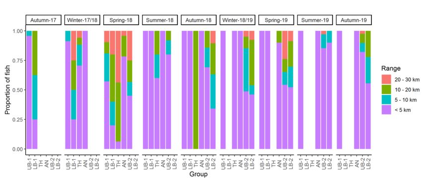
Fishtrack ltd.Fishtrack were also commissioned to undertake an assessment of spawning habitat quality and availability within the Upper Bure, as shown in figure 5. The fish tracking PhD funded by the project has now concluded and the thesis analysing the associated data has been published. The project plans to carry out further fish tracking following installation of the barriers to understand how the proposed biomanipulation of HGB and HB influences bream movement within the broads. The following is a summary of relevant sections of the PhD thesis (see Winter 2020 for full details) In total 181 bream were tagged from the Upper Bure, Lower Bure, Thurne, and Ant, between November 2017 and September 2018 (details in table 1). These fish were monitored between November 2017 and February 2020 using a network of 56 acoustic receivers deployed across the Rivers Bure, Thurne, and Ant (see figure 4). Table 1: Details of common bream sampling locations, tagging dates and acoustic tracking duration by group in the River Bure study system. Length and tracking duration are represented by the range of values, with mean ± SD in parentheses. Within the tagged bream their appeared to be different sub-populations adopting different movement behaviours with some populations largely resident, others undertaking partial migrations, and some making repeated ~25km migrations during the spawning season (see figure 5). This probably plays an important role in maintaining resilience within the population outside of the breeding season i.e. food availability. The fish tracking data showed HGB and HB are a significant spawning site for sub- populations of bream within the Upper Bure, Lower Bure, and Thurne. HGB and HB do not appear to play any role in spawning for bream using the Ant. There also appear to be populations of bream not visiting the Upper Bure during the spawning season, with these bream primarily visiting Ranworth/Malthouse Broad and Barton Broad during spawning season (see figure 6). Individual movement was highly consistent between years suggesting high levels of site fidelity, with mixing of different movement phenotypes during spawning, suggesting that different movement phenotypes comprised a single metapopulation that converged at particular off-channel sites to reproduce on an annual basis.
Figure 4: Map of the River Bure study system, eastern England, showing locations of
sampling locations, acoustic receivers, PIT antennae and temperature logger. Channel width
not to scale.

Figure 5: Total seasonal range of common bream in the River Bure study system,
expressed as the proportion of fish in each group and season for each set of values.
Figure 6. Total number of detections at each acoustic receiver during the 2019 spawning
period (a) across the entire study area and (b) in the Wroxham-Horning section of the Upper
Bure reach. Detections are scaled relative to the detection area of each receiver when
detection range = 200 m. Points are coloured according to the mean daily noise quotient,
with values < 0 indicating interference by tag collisions. Detections for fish classified
‘resident’, ‘migrant’, or other.
Spawning surveys carried out in 2019 by EA and Fishtrack observed aggregations of
bream in HGB and HB as well as spawning behaviour and egg deposit within HB. No
significant aggregations of bream were recorded elsewhere within the Bure, Ant,
Thurne system although some egg deposit was observed on the Ant.

Assessing WFD status of fish element

There is currently no tool for assessing the condition of the fish assemblage of
shallow lakes under WFD. Therefore the EA have not assessed the ecological status
of the fish community within HGB or any of the other lakes within The Broads. The
status of a tool for assessing the condition of fish assemblages in rivers is less clear,
but there has been no WFD assessment of the fish assemblage of the Bure
(Horstead Mill to St Benet's Abbey), Ant, or Thurne.

However, the lack of a classification of the fish community under WFD does not
remove the requirement to assess if the project will cause a deterioration of the fish
community. Therefore this report reviews the best available evidence to assess the
condition of the current fish community and whether the proposed installation of fish
barriers will cause a deterioration in the fish element both within HGB/HB and the
wider system.

WFD status of fish community within HGB & HB

Good ecological status (GES) under the WFD is defined as slight variation from
undisturbed conditions. Sediment sampling from HGB and HB has shown that these
broads were once dominated by macrophytes (including charophytes) (Goldsmith et
al. 2014). Indeed, Hoveton Great Broad and Hudsosn Bay are designated as
protected sites for H3140 Hard oligo-mesotrophic waters with benthic veg of Chara
spp and H3150 Natural eutrophic lakes with Magnopotamion or Hydrocharition.
These habitats and their associated communities, including fish, therefore represent
the undisturbed condition from which WFD status is assessed. With regards to the
WFD status of the fish assemblage this section aims to ascertain:

   •   What is the undisturbed fish assemblage for these habitats, and is a fish
       assemblage heavily dominated by two species, roach by number and bream
       by biomass, a slight variation from undisturbed conditions?

The response of fish communities to eutrophication is well documented with roach,
bream and carp eventually dominating the fish community (e.g. Jeppessen et al.,
2000; Moss, 2010), see figure 6. Surveys in the Broads have led to the same
conclusions. Where habitat complexity provided by macrophytes remains, the
piscivores (pike and perch) dominate by biomass. Tench, eels and rudd are also
found in greater abundance in these habitats. Conversely, under turbid, algal
dominated conditions roach and bream are more abundant and there are fewer pike, perch, tench, rudd and eel (refer to figure 7, Kelly 2008). The dominance of roach and bream Figure 6. Response of fish communities to under eutrophic conditions is not just a increase phosphorus (Jeppesen & symptom of eutrophication, these Sammalkorpi 2002) species play a critical role in the food web, which reinforces the turbid, algal dominated state. In effect, they act as a forward switch, maintain the stability of the algal dominated turbid state and make it harder to switch the lake back to a macrophyte dominated state, even if nutrient concentrations reduce (Bernes et al., 2015, Phillips et al., 2015). Large numbers of small roach significantly alter the zooplankton community in lakes, which reduces their ability to control the phytoplankton through grazing, allowing algal dominated water to persist. Bream also play an important role as benthic feeders re-suspending the sediment, increasing turbidity and uprooting macrophytes. They also promote nutrient release and cycling from the sediment. This also reinforces the algal dominated state (Breukelaar et al., 1994). The role of bream in increasing water turbidity and decreasing macrophyte cover, and therefore their potential to impact on WFD status is acknowledged by the EA’s Scientific and Evidence Services team in a report on Aquatic and riparian plant management (Bentley et al. 2014). Moss et al (1996), in their Guide to the restoration of nutrient-enriched shallow lakes, provides a summary of the characteristics of the most common fish species in lowland Britain in respect to their compatibility with shallow lakes restored to diverse plant communities (see figure 8). The more negative the score the more incompatible they are with lake restoration. It clearly shows that a fish community so heavily dominated by bream and roach as that in Hoveton Great Broad and Hudson’s Bay is not compatible with restoring shallow lakes, i.e. to WFD good status
and SSSI favourable status targets. It is of note that bream can coexist with a
vegetated state as part of a diverse fish community, but in such conditions they don’t
dominate the fish community, whereas in eutrophic conditions they do, and help
reinforce the algal dominated state (Moss et al, 1996).

Figure 7. Relative biomass and number of fish in the Broads in macrophyte dominated and
turbid conditions. Presented in Kelly (2008). Data from selected Environment Agency
(National Rivers Authority) fisheries surveys and surveys conducted for the Broads Authority.

                        Relative biomass of fish

                        Relative number of fish

The fish surveys of HGB & HB (detailed above) reveal roach and bream populations
which are likely to be having an impact on the condition of HGB and HB.

Perrow et al. (1999) reported that in open water with no refuges, >0.2 ind. m -2 of
zooplanktivorous fish, such as roach, may exert a negative effect on zooplankton,
although where there were submerged plants, the density may have to be much
higher (> 1 ind.m-2) to exert the same effect. Hindes (2017) reported finding more
than 5 roach individuals per m-2 in Hoveton Broad in spring, although this later
decreased it remained above 0.2 m-2 throughout the rest of the year. As Hoveton has
extremely sparse macrophytes this level of roach abundance has the capacity to
detrimentally affect the lake.

Although the exact boundaries of any relationship between fish biomass and
macrophyte cover remain difficult to define, a general rule of thumb appears to be
that a broad is unlikely to support good populations of plants with more than around 100 kg ha-1 of benthivorous fish (Kelly, 2008). At Hoveton in spring, a mean bream biomass of over 250 kg ha-1 was recorded, this declined to nearer 150 kg ha-1 in summer and declined further in autumn, but it rose to over 100 kg ha-1 again in winter (Hindes, 2017). The presence of such a high biomass of bream, particularly at the start of the growing season, has the capacity to detrimentally affect Hoveton Broad. Figure 8. Summary of the characteristics of the most common fish species in lowland Britain in respect of their compatibility with shallow lakes restored to diverse plant communities (from Moss et al 1996). Therefore the current fish assemblage inhibits WFD GES (Good Ecological Status) being achieved for macrophytes, phytoplankton, and macro-invertebrates. Given the aim of WFD is to achieve GES in open waters and rivers, a fish population which prevents overall GES being achieved cannot be considered to be in ‘Good Status’. As GES is defined as slight variation from undisturbed conditions and we know that in the past when the broads were not subject to nutrient enrichment and it supported macrophytes associated with clear water conditions, this is what GES would look like. GES for the fish assemblage would therefore be one that is compatible with such conditions, so it is likely to contain bream and roach but they would not dominate the assemblage, which would be more diverse and dominated by piscivores. We know the Broads were once dominated by macrophytes pre- eutrophication as evidenced from sediment core studies (Goldsmith et al. 2014) and the scientific literature described above shows that this is not compatible with a fish community dominated by bream and roach. This is also evidenced by the more
diverse balanced fish communities observed in broads with clear water macrophyte
dominated conditions (refer to figure 7). There is no doubt that bream and roach will
form a part of a more undisturbed broadland community, but not to the numeric
extent currently observed.

There is no evidence to suggest that any reduction in the dominance of bream would
be considered as a deterioration in WFD ecological status on the contrary it would be
considered an improvement. To test this assumption in the absence of a UK shallow
lake classification tool the EA trialled the use of a shallow lake fish classification tool
from Holland. This model comes with very many caveats as it is not Broadland
specific, but it does consider high bream biomass as a percentage of community
biomass as an indication of eutrophication and is detrimental to the WFD status of a
lake (figure 9). Therefore, reducing bream number would generally result in an
improvement in WFD fish status.

There is also a proposed new standard approved for consultation by UK admins
based on an eDNA fish tool for use in the UK. This supports the findings from the
Dutch classification as this sees the presence of bream and roach as negative
indicators in eutrophic lakes so that a decrease in number would improve the lake
classification. Together these two tools support the view that the current fish
assemblage would not be considered to be at GES and reducing bream and roach
would result in an improvement not a deterioration in the fish community WFD class.

Figure 9. Class boundary information for fish from Dutch fish classification tool.

WFD status of fish community within the wider Broads system

The fish tracking data has provided new evidence on the role HGB/HB plays within
the wider Bure/Ant/Thurne system, and highlights the potential for bream numbers to
reduce in the wider system if they fail to spawn elsewhere or less successfully when
the fish barriers are installed on HGB. Therefore, there is a requirement to consider if
installing fish barriers at HGB will impact the WFD fish class of the waterbodies that
make up the wider Broads system.
As with lakes the objective for WFD in rivers is for the ecology to be in good
condition with the highest status most akin to reference condition, where the ecology
is unimpacted. Consequently, the highest ecological status class for fish in rivers
would be similar to a fish assemblage unimpacted by human influence. Such a fish
assemblage would not be reliant on elevated bream and roach numbers in HB or
HGB, which are a symptom of anthropogenic eutrophication, as this reflects very
impacted conditions. Restoring the natural fish assemblage in HGB and HB will help
restore the natural assemblage in the connected river system as it will provide a
refuge, and spawning habitat for a range of fish species that use the Bure and
potentially provide a source for recruitment.

The broad’s lakes and rivers are a highly interconnected system as shown by our
fish tracking data. The condition of the fish communities in the rivers will be heavily
linked to the health of the broadland lakes and the fish communities they support.
For the river fish communities to be considered to be in GES, (defined as slight
variation from undisturbed conditions) the attached broads would also need to be
healthy with balanced lake fish communities associated with clear water and
macrophytes to not cause variation from undisturbed conditions. The river fish
community cannot to be considered to be at GES if it is being influenced by bream
and roach dominated communities which are a consequence of eutrophication as
observed in the middle Bure broads. Therefore, a decline in bream that results in a
more natural fish community in the connected broads cannot be considered to be a
decline in the WFD status of the river fish community.

PASE surveys of the upper Bure broads indicate that they also support fish
communities which is largely dominated by bream and roach, not a more diverse
community dominated by piscivores which might be expected in unimpacted
conditions as discussed above. As reported in the 2019 WFD condition monitoring
these broads are failing to achieve GES for phytoplankton and macrophytes and
therefore a reduction in bream and roach numbers, if observed as a result of the
proposed fish barriers at HGB and HB, would be considered an improvement in
WFD fish status not a decline.

Data from the fish tracking shows the bream populations in the Ant are largely
independent of the sub-populations spawning on HGB and HB, therefore there will
be no impact on the WFD status on the Ant if bream numbers decline.

The fish tracking data gathered as part of the PhD indicates that bream from the
Thurne undertake annual migrations of up to ~25km to spawn in HGB and HB. Such
migrations indicate the value of the Thurne as a feeding habitat outside of spawning
season and there is no evidence to suggest bream would stop utilising this resource
when barriers are installed on HGB. Therefore, these populations of bream would
only be impacted if they fail to spawn elsewhere or if spawning success was
significantly reduced when the fish barriers are installed on HGB.

Such a decline in spawning success is not anticipated as a result of the project.
Bream are a very common species across England (and indeed northern Europe),
found in a wide variety of waters from ponds and canals to large lakes and slow-to-
moderate flowing rivers (Maitland, 1972). This suggests they are able to spawn
successfully in a broad range of environments. Indeed, locally bream will attempt to
spawn on a wide variety of substrates including lilies, sedge roots and tree roots. It is
therefore highly unlikely that within the wider broadland catchment that HGB offers
the only suitable spawning habitat for bream. It is also very unlikely – given that
bream have already been recorded covering large distances and wide areas - that
bream would not be able to access such suitable spawning / feeding / loafing habitat
elsewhere in the highly connected Broads system, even if it does not occur locally to
HGB.

It is bream’s tolerance to a wide range of conditions, their ability to successfully
colonise and maintain strong populations in a range of different habitats across the
UK, which has been the key to their success. In the literature bream are described
as favouring rich, muddy and weedy lakes where their sticky eggs are deposited
onto submerged macrophytes. However, many fully enclosed lake sites maintain
strong populations of bream with a macrophyte assemblage which is largely limited
to an emergent fringe and effectively devoid of submerged forms – like many of the
broads, including Hoveton. The highly fecund nature of bream and their ability to
persist in environments in which their favoured spawning habitat is absent indicates
a strong competitive advantage over other species with more restricted spawning
habitat requirements.

Each female may spawn several times over a week or so until all eggs are laid. The
number of eggs laid depends on the size of the female but can range from 90,000 –
340,000 (Maitland & Campbell 1992). Adámek et al. (2002) recorded the average
number of eggs obtained by stripping 1 kg of female bream biomass from the river
Sow and Trent to be in the range of 93,642 ± 20,896 and 151,179 ± 25,123,
respectively. Given the reproductive potential of the species, spawning success does
not have to be frequent to sustain a population.

So in summary, whilst a number of bream might preferentially choose HGB and HB
due to habitat quality and the low disturbance levels, it is likely they will use lower
quality habitats if HGB and HB were unavailable. Fish tracking data indicates that
indeed there are populations of bream that do not utilise HGB and HB for spawning.

Given that we expect bream to find alternative spawning sites following the
installation of fish barriers at HGB, a more likely mechanism for WFD decline in the
wider system is increased numbers of bream in currently less impacted broads, as
identified by the PhD study:

 ‘as bream are ecological engineers, and their presence can be linked to increased
turbidity and eutrophication in shallow lakes…population disturbance in one area
could drive the evolution of a new behavioural strategy, with unpredictable
consequences for aquatic ecology in neighbouring reaches’ (Winter 2020)

This risk is considered de minimis given the heavily degraded nature of The Broads
with the majority of waterbodies classified as Poor or Moderate for phytoplankton
and macrophytes. However, as outlined in the project monitoring plan (HWRP
Monitoring Plan addendum_27.10.20) the project will be funding a 3 year
continuation of the fish tracking undertaken by the PhD, which will highlight if
significant proportions of bream are observed at sites not previously utilised (as
indicated by the original fish tracking). This will allow assessments of the potential
impacts of the bream should such a pattern occur. In addition, the formation of the
Hoveton Fisheries Advisory Group (as detailed in ‘HWRP Fisheries Advisory Group.
January 2021’) provides a mechanism for highlighting and delivering any further
monitoring or management needs identified.

Summary

   •   The fish communities of the middle Bure broads are dominated by roach in
       number and bream by biomass. Such communities are highly indicative of
       lakes suffering from eutrophication, and such fish communities help maintain
       poor ecological condition with turbid waters and low macrophyte diversity and
       coverage.

   •   A fish community which helps maintain poor ecological status is not
       compatible with GES under the WFD and should be considered as in poor
       status. Therefore restoring the fish community to one not dominated by bream
       and roach even if that means a decline (but not loss) of bream and roach
       associated with the installation of fish barriers at HGB cannot be considered a
       decline in the WFD status of the fish community, either within the individual
       broads or the rivers.

   •   Bream and roach will form a part of a more undisturbed broadland fish
       community, but not to the numeric extent currently observed.

   •   A large scale decline in bream associated with the temporary closure of HGB
       and HB is unlikely due to the adaptability and fecundity of bream, as
       demonstrated by their success throughout UK waters.
• A redistribution of bream within the wider Broads as a result of proposed
works driving a decline in WFD status in less impacted waterbodies is
considered very low, in part due to the already highly impacted condition of
The Broads. However, mechanisms are in place within the projects monitoring
programme and the formation of the ‘Hoveton Fisheries Advisory Group’ to
monitor and if required mitigate such an event.
Overall the project is still expected to provide long-term benefits through significant
improvements in habitat quality, food availability and improved spawning structure.
The diversity of fish in the broad is expected to improve, with a higher proportion of
typical Broadland fish – tench, perch, rudd – expected to be present once the broad
is established in a clear-water, plant dominated state.
References
Adámek Z., Andreji J. & Henshaw, A. (2002). Stripping fecundity of common bream
(Abramis brama L.) from the rivers Trent and Sow (Nottinghamshire, UK).
Aquaculture International 12: 133–137, 2004.
Bentley, S., Brady, R., Hemsworth, M., Thomas, L. (2014) Aquatic and riparian plant
management: controls for vegetation in watercourses. Project: SC120008/R4.
Environment Agency, July 2014.
Bernes, C., Carpenter, S., Gardmark, A.,Larsson, P., Persson, L., Skov, C., Speed,
J., and Van Donk, E. (2015) What is the influence of a reduction of planktivorous and
benthivorous fish on water quality in temperate eutrophic lakes? A systematic review
Environmental Evidence 4:7
Breukelaar, A.,Lammens, E., Klein Breteler, J., and Tatrai, I. (1994) Effects of
benthivorous bream and carp on sediment resuspension and concentrations of
nutrients and chlorophyll a. Freshwater Biology 32 113-121.
Goldsmith, B., Lambert, S., Henderson, G., Sayer, C.D., Goodrich, S. and
Matyskova, V. (2014) Hoveton Great Broad Macrophyte Study: Using the sediment
record to inform lake restoration. ECRC Research Report Number 160. Ensis Ltd.
University College London.
Hindes, A. (2017) Hoveton Great Broad Restoration project: Seasonal comparative
fish surveys summary report. Fishtrack report to Natural England
Jeppesen, E., Jensen, J., Søndergaard, M., Lauridsen T., and Landkildehus, F.
(2000) Trophic structure, species richness and biodiversity in Danish lakes: changes
along a phosphorus gradient. Freshwater Biology 45, 201–218
Jeppesen, E. & Sammalkorpi, I. Lakes, In: Handbook of ecological Restoration.
Volume 2: Restoration in Practice. M. Perrow & A. Davey (Eds). (2002). Cambridge
University PressYou can also read