Upper Bush Conservation Area Appraisal
←
→
Page content transcription
If your browser does not render page correctly, please read the page content below
APPENDIX 3

Upper Bush Conservation Area Appraisal
Purpose of the Conservation Appraisal

The Conservation Area Appraisal guides residents and planners in the best ways
of caring for the historic environment in Upper Bush. It summarises the history
and architecture of the area, defines the features that make the area special and
sets out policies for preserving and improving its special character. As
supplementary planning guidance the policies set out in this appraisal will be
used when considering applications for planning permission.

This document also respects Medway Council’s ‘duty of regard for the purposes
of the Area of Outstanding Natural Beauty designation’ with regards to the Kent
Downs AONB.

Key Characteristics of the Area

Upper Bush is a small hamlet of medieval origin situated in open countryside. Its
key characteristics are:
   • Unspoilt rural surroundings
   • High quality historic buildings in a good state of preservation
   • The hamlet is free of modern suburban development
   • Few poor quality modern alterations and extensions
   • Landscaping around houses in keeping in with the rural character of the
      area

History

Upper Bush has its origins as a small hamlet that grew up on what is now the
North Downs Way, then a well used trade route, during the medieval period.
There is no separate reference to the hamlet in the Domesday book and the first
recorded mention of the settlement is in 1320 when the then bishop of
Rochester, Hamo de Hythe, is recorded as visiting the manor of Cuxton and
holding court in the Chapel at Birch. The site of the chapel is not known. By the
late medieval period Upper Bush had developed into a small hamlet with the
building of at least two substantial timber-framed structures, High Birch and
Borrow Hill House. Upper Bush Farmhouse, which stood to the west of the
settlement, is also likely to have had a medieval origin. It is unclear whether there
were other, less substantial, medieval dwellings on the site.

The hamlet formerly formed part of the Cobham estate of the Darnley family. It
appears to have been a relatively late acquisition, with the majority of the land in

                                         1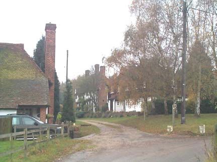
the hamlet being added to the estate between 1797 and 1842 and further
properties being added during the latter 19th century. Before 1797 Upper Bush
was part of Lord Romney’s Estate in Cuxton.

Ownership of the Upper Bush before this date is unclear. It may once have
formed part of the manor of Cuxton, which was held by the Bishop of Rochester
in the medieval period, and passed to the Dean and Chapter of Rochester
Cathedral after the reformation. However, it is not mentioned in a survey of the
manor undertaken in 1649 and it is possible that the hamlet originally formed part
of the Whorne’s Place estate, which had been held by ancestors of Lord Romney
since the 15th century.

The hamlet had developed into a thriving agricultural settlement by the 1840s.
The principal farmstead by this time was Upper Bush Farmhouse, which featured
a pair of cottages, large barn, outbuildings and a cart shed. A further large house
was situated to the North West. Smaller cottages were grouped around the
green. These were generally small yellow brick or weatherboarded buildings.
High Birch and Borrow Hill house were both divided into three cottages by this
time.

Further development in the second half of the 19th century resulted in the
rebuilding of the farm buildings of Upper Bush Farm, including new barns and an
oast house along with the demolition of earlier barns and cottages. Additional
cottages and the non-conformist Hope Chapel were also built along the north
side of Bush Road. The bungalows at the entrance to the conservation area were
added in 1923. The hamlet reached its largest extent just before the Second
World War, when it contained 22 houses, an off-licence and a baker. During this
time the Old Bakery appears to have been at the heart of the village as it
featured a bakehouse, brewhouse, flour store and off license to the rear, much of
this incorporated in a now demolished extension.

Upper Bush was transformed shortly after World War II when the Cobham Estate
was acquired by the City of Rochester. In 1960 Strood Rural District Council
decided to clear what was then considered substandard housing in the hamlet.
This left only five buildings standing and involved the demolition of several
historic buildings including Upper Bush Farmhouse. It was originally planned to
demolish Borrow Hill House and High Birch but a campaign organised by local
people led to the recognition of the historic worth and restoration of these
buildings. The only modern structures to be erected are a group of barns at
Upper Bush Farm. Conservation Area status was confirmed on the area in 1994.

Archaeology

The land at the centre of the village must be regarded as archaeologically
sensitive as the remains of further medieval and early modern buildings may
survive below ground. The zone of archaeological potential is shown on Map 2.

                                        2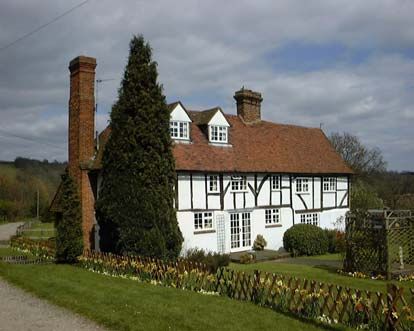
There are no scheduled ancient monuments in the area, neither is any part of the
area at present designated as an Area of Archaeological Potential.

Landscape

The key characteristic of Upper Bush is unspoilt rural setting. The hamlet is
located in the midst of open arable farmland land on a spur elevated land at the
confluence of the Bush and Cuxton valleys. The ridge tops of these valleys have
a dense deciduous tree cover that broadens out into Horseholder’s Wood to the
south of the settlement. The surrounding farmland is remarkable in that, apart
from a group of buildings lining Bush Road to the north, it is completely
undeveloped.

The only vehicular access is from the north and consists of one narrow access
road, partially lined by hedgerows. There are however, six footpaths converging
from various directions. The North Downs Way, which follows the route of an
ancient cross country path passes through the hamlet. The distinctive character
of the access road is recognised by its classification as a rural lane.

Horseholder’s wood and the stands of trees to the north and east of the hamlet
ensure that the character of the settlement is overwhelmingly one of seclusion
with views being limited to only a few glimpses of the settlement obtainable from
surrounding paths and roads. On approaching from the footpaths, awareness of
approaching the settlement is concealed by tree cover until the centre has almost
been reached. When approaching by road from the north the settlement is almost
invisible, with only the modern farm buildings of Bush Farm being visible in views
from Bush Road and the northern slopes of the Cuxton Valley.

Once inside Upper Bush the slightly elevated nature of the land gives good views
out of the settlement to Cuxton to the east and Lower Bush and, more distantly,
the Medway Bridge and Rochester to the north.

Upper Bush Road - looking North           Upper Bush - looking south

Upper Bush itself is a relatively compact settlement covering and area of only
approximately eleven acres. This is typical of historic villages in this part of Kent

                                         3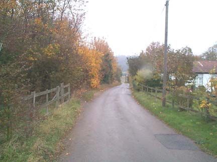
where nucleated rather than dispersed settlements are the norm. While individual
buildings are set in large gardens the density of settlement is very low, houses
tend to cluster together towards the front of the plots that they stand in. This
gives the hamlet a clearly defined centre around a small triangular green
between Borrow Hill House and The Cottage.
Landscaping around the settlement is simple, with grass verges, tarmac roads
and gravel paths. Boundary treatments are attractive, with front gardens bounded
by low brick walls, hedges and timber lattice and post and rail fences. Mature
trees and well planted front gardens make an important contribution to the
character of the village centre, reinforcing its rural nature. There is little in the
way of street furniture but the approach to the hamlet is marred by telephone and
power lines.
Built Environment
The domestic buildings at Upper Bush are all high quality rural vernacular
buildings ranging in date from the late medieval period to the 20th century. All the
structures retain much of their traditional detailing and make a positive
contribution to the character of the area. Dominant materials and features include
large steeply pitched Kent peg tile roofs, often hipped, and tall redbrick chimneys.
The simple, bold massing of the roofs, contrasted by the chimneys is a distinctive
feature of all the buildings in the centre of the hamlet. Walls are an eclectic
mixture of timber framing with plastered infill, painted brick and weatherboarding.
All windows are timber casements fitted flush with the buildings’ façade.
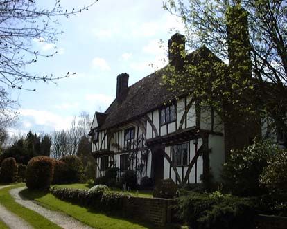
The key buildings in the area are Borrow Hill House and High Birch, both of
which are medieval timber framed hall houses that have been restored. Borrow
Hill House is relatively modest, with little in the way of ornamentation whilst High
Birch is a much grander building of the Wealden type with decorated moulded
doorways, ‘Kentish’ style tension bracing, coving and jetties. Both buildings are
listed, Borrow Hill House at grade II and High Birch and grade II*.
High Birch Borrow Hill House
4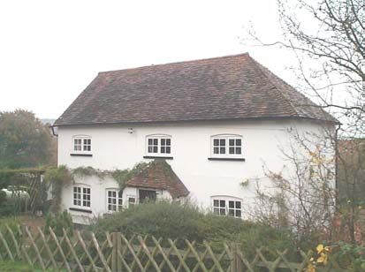
Overstrands, also known as the Old Bakery, and the Cottage are thought to date
from the 18th and early 19th centuries respectively. A late 20th century extension
has been added to the side of the cottage without harming the building’s
character.

The Old Bakery                           The Cottage

Beeches Bungalows are much more modern buildings but are attractive and still
very much within the rural vernacular style, being very simple with low pitched
corrugated iron roofs, weatherboarded walls, low brick chimneystacks and
casement windows

Beeches Bungalows                        Upper Bush Farm

Upper Bush Farm features a late 19th century timber framed barn with a
corrugated iron roof, an attractive structure that makes a positive contribution to
the conservation area. The other buildings in the farmstead are a late 19th
century stable block with painted brick walls and an asbestos roof and a pair
modern asbestos clad barns barn. Neither are attractive structures.

Development Pressures

Much of the character of Upper Bush is derived from its secluded rural location.
This fact is recognised by its designation as part of the North Downs Area of

                                        5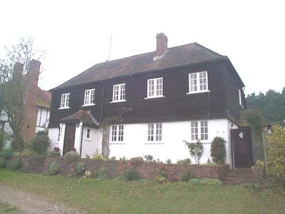
Outstanding Natural Beauty, the Kent Downs Special Landscape Area and the
Metropolitan Green Belt. The planning restrictions associated with this mean that
there is little opportunity for new buildings within the conservation area. The high
quality of the existing buildings in the area means that there is a presumption
against the demolition of all buildings apart from the modern structures at Upper
Bush Farm.

Any new build at Upper Bush Farm would have to be of traditional form, use
traditional materials and be for agricultural, forestry or outdoor recreational uses.
There would be a presumption against the conversion of the 19th century farm
buildings into domestic use unless it was proved that no other economic use
could be found for them. The stable block and modern farm buildings are not
considered to be of sufficient quality to warrant conversion should they become
redundant.

All the buildings in Upper Bush retain traditional building materials and detailing,
including Kent peg tiles, tall chimney stacks, timber casement windows and
weatherboarding. Cast iron guttering remains on some structures but has often
been replaced by uPVC. Boundary treatments are also simple and free of
suburban clutter such as railings or chain link fencing. The character of other
conservation areas in Medway has suffered from the loss of these features and,
as they are not protected, there is no guarantee that the buildings in Upper Bush
will continue to retain these features.

There is limited pressure to extend existing buildings in the village. While limited
extensions may not damage the character of the area overly large and poorly
designed extensions will have a detrimental effect on the character of the area.
New outbuildings and garages would be expected to be of exceptional quality,
modestly scaled, of traditional design and use traditional materials.

Another pressure is the increased use of land for equestrian purposes in the
surrounding area. While the diversification in the use of land is to be supported
the building of stables and erection of equestrian fencing on the fields
surrounding the conservation area would be held to be damaging to the
character of the area.

Policies
1.   There will be a presumption against the demolition of buildings that make a
     positive contribution to the Conservation Area
2.   There will be a presumption against the erection of new buildings in the
     Conservation area.
3.   Proposals for alterations and extension and outbuildings should be modestly
     sized, respect the distinctive architecture style and character of the existing
     building in terms of bulk, height, position, size and detailed design.

                                         6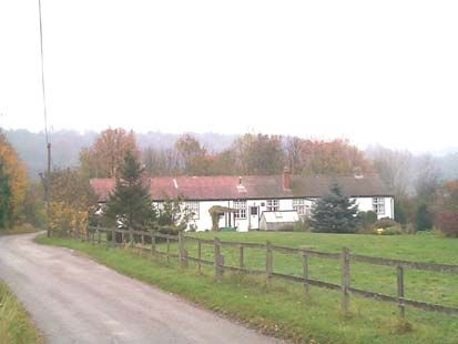
4.   Large conservatories will not generally be considered acceptable.
5.   Alterations which result on the loss of chimneys, or have a detrimental effect
     on roofscapes, including the insertion of rooflights and dormers onto
     prominent roofslopes will normally be resisted.
6.   The Council will encourage the retention of original design features, such as
     windows and doors, and where necessary will require the use of replica
     features in traditional materials in replacement of these works. Aluminium
     and uPVC replacement units will not normally be considered acceptable.
7.   In new works and replacement work, the Council will require that all
     materials, in particular brick and tile type, match the original building.

8.   The retention and replacement of cast iron guttering will be encouraged.
9.   The positioning of satellite dishes in prominent positions will be
     discouraged.

10. Any alterations or replacement buildings in Upper Bush farm will be
    expected to preserve the agricultural character of the farmstead and make
    use of traditional detailing and materials.
11. Trees and area of woodland will be further protected by the creation of
    additional Tree Preservation Orders where appropriate.

12. The retention of traditional boundary treatments will be encouraged.
13. The retention of traditional road surfaces and floorscapes will be required.
    Proposals for new and replacement hard surfacing around buildings must
    respect the character and appearance of the area in terms of materials and
    extent.
14. The Council will encourage statutory undertakers to remove overhead
    cables. New street lights must be in character with the area.
15. New signage, including footpath signs, will be expected to be kept to the
    absolute minimum and respect the rural nature of the area.
16. There will be a presumption against the building of new stables and
    equestrian fencing on land within the conservation area.
17. The Council will endeavour to preserve sites and structures or
    archaeological or historic significance. Land within the Zone of
    Archaeological Potential should be treated as belonging to Urban
    Archaeological Zone 2 in the Kent and Medway Structure Plan, SPG3
    (Supplementary Planning Guidance on Archaeology).

                                        7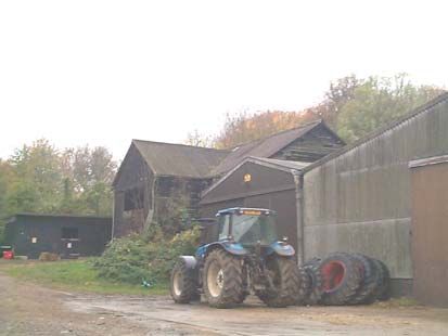
Introduction of an Article 4(2) Direction

The area is unusual in that there has been no inappropriate development of
residential properties such as the fitting of concrete roof tiles, uPVC windows, the
rendering of façades or the erection of suburban boundary treatments such as
railings or brick walls.

However, this situation is not guaranteed to continue and the area is thus in a
vulnerable position where much of the historic character of the area could easily
be lost.

For this reason the Council has, therefore, introduced an Article 4(2) Direction.
Planning permission is required for the following works to a house fronting a
road, path or public open space:

   •   Building, altering or removing a chimney
   •   Enlarging, improving or altering a house. This includes replacing windows,
       doors, and guttering and applying bargeboards
   •   Altering a roof (including re-roofing in a different material and fitting roof-
       lights)
   •   Building a porch
   •   Laying a drive or path
   •   Building, altering or demolishing a gate, fence, wall or railings.
   •   Painting, rendering or pebble dashing the outside of the property (not
       including painting woodwork).

There is no charge for making this type of planning application. The need for
planning permission for extension, conservatories and roof alterations to the rear
of the property would not change.

                                          8
BUILDING AGE
1400-1600 Demolished Structure
1600-1800 Listed Building
1800-1860 Building of
Architectural Merit
1860-1900 N
1900-1930 Conservation area
Post 1930 Boundary
0 Scale in metres 100
UPPER BUSH CONSERVATION AREA APPRAISAL:
MAP 1 -BUILDING TYPE
9N
20
25
30
25
35
40
30
45
50
40
Conservation Area Boundary
Rural Lane
Contour (5 metre intervals) 35
40
50 metre contour
45
Tree Cover
35
0 Scale in metres 100
UPPER BUSH CONSERVATION AREA APPRAISAL:
MAP 2 -Topography and Tree Cover
10Listed Building
Building covered by
proposed Article 4(2)
Direction N
Conservation area
Boundary
0 Scale in metres 100
UPPER BUSH CONSERVATION AREA APPRAISAL:
MAP 3 -PROPOSAL
11You can also read