Uttarakhand - Glacier Ice Avalanche Induced Flash Flood, February 2021
←
→
Page content transcription
If your browser does not render page correctly, please read the page content below
Uttarakhand - Glacier Ice Avalanche
Induced Flash Flood, February 2021
On 7th February 2021, an ice sheet broke off from the Nanda Devi glacier,
triggering a cascade of events that led to widespread damage in
Uttarakhand's Chamoli district. The incident occurred in the Rishi Ganga
Basin, a tributary of Dhauli Ganga. Dhauli Ganga River rises about 5,070
m and meets Alaknanda at Vishnuprayag, with a total length of about 94
km. Several glaciers exist in the upper part of the Dhauli Ganga River
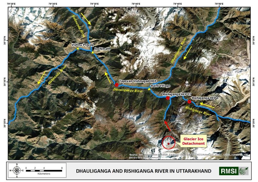
Basin. Figure 1 shows an aerial map depicting the Dhauli Ganga River,
Rishi Ganga River, locations of the hydropower projects, and source of the
event.
CAUSE
Though the jury is still out analysing the cause, glaciologists and
geologists identified a steeply hanging bit of the Nanda Devi glacier at an
altitude of 5600 m. This is believed to have developed a crack in the Figure 1: Map showing the rivers, hydropower projects and source of the event
glacier’s body and possibly caused detachment of a large extent of glacier
During this period (January/ February), temperatures are very low in
from its main body. The ice-avalanche, covering approximately 14 sq km
the glaciated regions of the Himalayas. There is minimum flow in the
area, swept debris from the valley, thus, pushing a large amount of rock,
rivers due to the absence of liquid precipitation at high elevations. All the
moraines, mud, and debris, and prompting a flood in the Rishi Ganga,
water bodies/lakes freeze at high altitudes. Therefore, the possibility
Dhauli Ganga, and Alaknanda rivers. The floodwater travelled over 100
of Glacier Lake Outburst Flood (GLOF), which represents a sudden
km down steep slopes through the Ganga tributaries before attaining its
release of water from a glacier/ moraine-dammed lakes, is
normal condition in the channel.
negligible.
DISCLAIMER: This report contains analysis that is based on publicly available data. The actual extents and intensities from catastrophic events may differ from the results of this simulation analyses due to accuracy and
quality of available data. RMSI specifically disclaims all responsibilities, obligations, and liability with respect to any decisions or advice made or given as a result of the information in this report.
1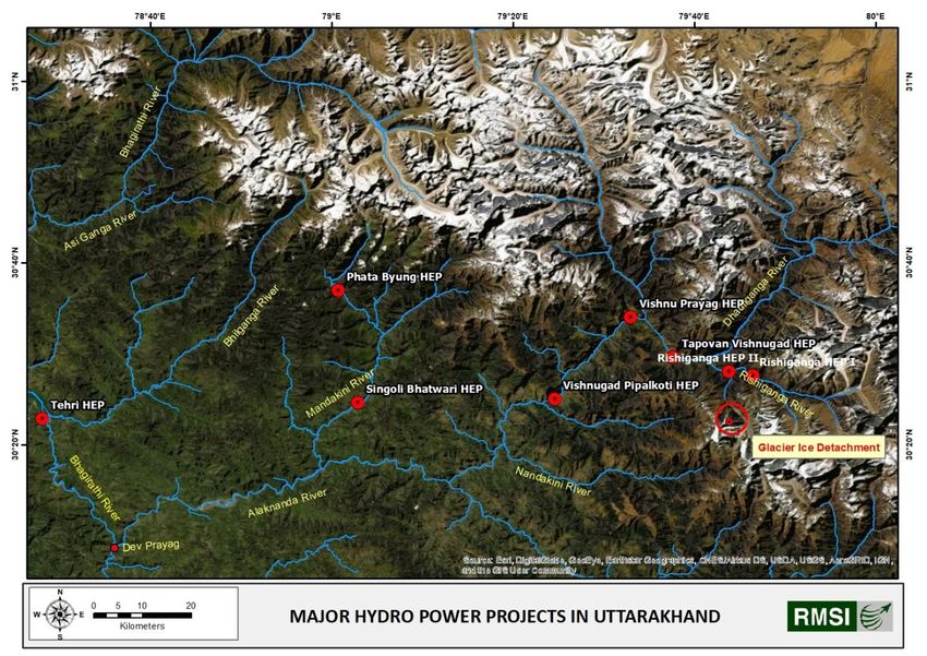
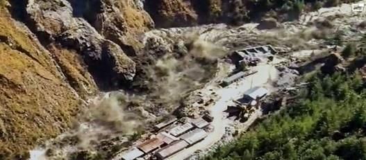
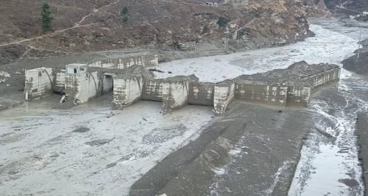
The Uttarakhand incident does not appear to be a GLOF. This event Further, the flash flood extensively damaged NTPC’s 520 MW Tapovan-
possibly occurred due to the detachment of ice from a glacier and can Vishnugad Hydropower Project, which is under construction
be termed as ‘Glacier Ice burst’ or ‘Ice Avalanche’. downstream on the Dhauli Ganga River.
The intense flow of rock and ice can generate tremendous heat, which Tapovan-Vishnugad Hydropower Project is a run-of-the-river
can melt large volumes of ice, leading to a huge water volume that flood hydroelectricity project, whereby little or no water storage is provided.
rivers in a flash. Various government organizations such as the Wadia Vast quantities of sediment were deposited in the Tapovan reservoir and
Institute of Himalayan Geology (WIHG), Dehradun; Indian Institute of tunnels. The height of sediment deposition in the Tapovan reservoir was
Remote Sensing (IIRS), Dehradun; Indian Institute of Technology (IIT), about 35 m. Water and debris damaged and washed away structures and
Roorkee & Indore, and others dealing with remote sensing, glaciology, machinery.
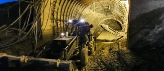
geology, geomorphology are investigating to identify the exact cause Several project staff and labourers were trapped in the tunnels filled by
behind this disaster. At present, different experts are offering different debris (Figure 2).
hypotheses. We expect these activities to conclude after the field visits
and data analysis in the days to come.
IMPACT
The glacial burst triggered an avalanche and a deluge in the Rishi Ganga,
Dhauli Ganga, and Alaknanda rivers. It impacted the river channels and
the hydropower projects located in the downstream area. Ice pieces of
the glacier were observed up to Pipalkoti located on the Alaknanda
River, about 50 km from the Rishi Ganga power project.
This event is reminiscent of the Kedarnath deluge of 2013, which led to
widespread devastation in Uttarakhand.
The gushing water carrying the debris and boulders along with the ice
mass caused significant damage in this area. This flowing ice mass swept Figure 2: Images showing damage due to sediment flow into tunnels and reservoirs
away the 13.2 MW Rishi Ganga Hydel Project. The damage to its
hydraulic structure led to the immediate release of water stored, thus,
creating a situation similar to dam failure.
DISCLAIMER: This report contains analysis that is based on publicly available data. The actual extents and intensities from catastrophic events may differ from the results of this simulation analyses due to accuracy and
quality of available data. RMSI specifically disclaims all responsibilities, obligations, and liability with respect to any decisions or advice made or given as a result of the information in this report.
2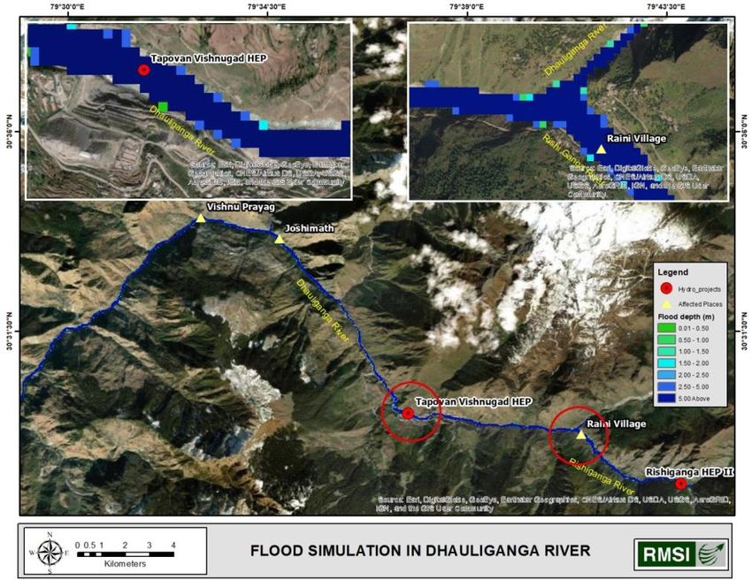
The Rishi Ganga Power Corporation and NTPC are assessing the damage                                                                         Table 1: List of major hydropower projects (>25 MW) in Uttarakhand

to their projects. Preliminary estimates suggest damages worth INR 1500-                                                          Sl.      Project                             Organization               Capacity            River
2000 crore.
                                                                                                                                  1        Lata-Tapovan                        NTPC                       171 MW              Dhauli Ganga
A massive search and rescue operation is underway by the State Disaster                                                           2.       Tapovan-Vishnugad                   NTPC                       520 MW              Dhauli Ganga
Response Force (SDRF) of Uttarakhand along with a unit of the Indo-
Tibetan Border Police (ITBP), with 30 confirmed deaths so far and over                                                            3        Vishnuprayag                        Jaypee                     400 MW              Alaknanda
                                                                                                                                           (Commissioned)                      Group
150 missing.
                                                                                                                                  4.       Tehri                               THDC                       1000 MW             Bhagirathi
The disaster also washed away five bridges of the Border Roads
                                                                                                                                           (Commissioned)
Organization that connected narrow roads in the hills with 13 villages,
including Gahar, Bhangyun, Raini Palli, Pang Lata, Suraithota, Tolma and                                                          5.       Vishnugad-Pipalkoti                 THDC                       444 MW              Alaknanda
Fagrasu. Out of 17 Gram Sabha areas affected by the disaster; 11 were                                                             6.       Naitwar-Mori                        SJVNL                      60 MW               Tons
inhabited, while the residents in the other areas had moved to lower
                                                                                                                                  7.       Phata-Byumg                         LANCO                      76 MW               Mandkani
areas due to winter.
                                                                                                                                  8.       Singoli-Bhatwari                    L&T                        99 MW               Mandakani
EXPOSURE
Although this event damaged two hydropower projects, many hydropower
projects are vulnerable to natural disasters caused by floods, cloud burst,                                                     The location of major projects is shown in Figure 3. To estimate the total
GLOF, snow avalanche, ice avalanche, landslides, and rockslides, etc., in the                                                   cost of these projects, one can consider INR 7-8 crore per MW.
Himalayan region.
NTPC’s Tapovan-Vishnugad project was under construction when the
disaster occurred, while the Rishi Ganga project had resumed generating
power since June 2020. Nearly 75 percent of the total cost of the
Tapovan-Vishnugad project, estimated to be about INR 4000 crore, has
been spent.
A list of important projects under different stages of development in
Uttarakhand is given in Table 1.

DISCLAIMER: This report contains analysis that is based on publicly available data. The actual extents and intensities from catastrophic events may differ from the results of this simulation analyses due to accuracy and
quality of available data. RMSI specifically disclaims all responsibilities, obligations, and liability with respect to any decisions or advice made or given as a result of the information in this report.
                                                                                                                                                                                                                                             3
Figure 3: Map showing major Hydro Power Projects in Uttarakhand
                                                                                                                                           Figure 4: Map showing the extent and depth of flood along with affected areas
In October 2020, the National Disaster Management Authority (NDMA)
                                                                                                                                The flood model was validated at two locations near Raini village where
had issued detailed guidelines on how to reduce and deal with disasters
                                                                                                                                flood depth for a short duration was observed around 12-15 m as
caused by what is scientifically called Glacial Lake Outburst Floods
                                                                                                                                published by some news agencies. Modelled flood depth near NTPC
(GLOFs).
                                                                                                                                Tapovan-Vishnugad project was also validated where flood depth of 1.5
ANALYSIS                                                                                                                        m to 2.0 m was reported near river bank close to the project site. The
To understand the hydraulic behaviour of the flood event, RMSI                                                                  Central Water Commission (CWC) has published water level information
attempted to map the severely affected areas based on publicly available                                                        at Joshimath gauging site for this event. The simulated flood depth at
information about the event and applied flood modeling software (HEC-                                                           Joshimath gauging site was also validated with water surface elevation
RAS-2D) to simulate possible flooding conditions as shown in Figure 4.                                                          (1,388 m) observed by CWC at 11:00 AM on 7th February.

DISCLAIMER: This report contains analysis that is based on publicly available data. The actual extents and intensities from catastrophic events may differ from the results of this simulation analyses due to accuracy and
quality of available data. RMSI specifically disclaims all responsibilities, obligations, and liability with respect to any decisions or advice made or given as a result of the information in this report.
                                                                                                                                                                                                                              4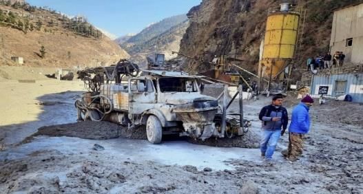
You can also read