Gold in New Hampshire - New Hampshire Department of ...
←
→
Page content transcription
If your browser does not render page correctly, please read the page content below
GEO-1                                                                                        2020

                                    Gold in New Hampshire
Yes! New Hampshire has gold! However, to date, only
small quantities have been found in some of the state’s
bedrock (the solid rock under the soil) and in the
gravels at the bottom of some streams (as placer
deposits). When gold is found in the bedrock, it usually
occurs in veins – long, narrow mineral rich “streaks.” It
is removed by breaking up the rock and extracting the
gold.

New Hampshire has a brief but colorful history of hard
rock mining. Gold was discovered in Lyman, N.H., in
1864, sparking a minor rush. Several small mines soon
opened in the Bath, N.H., area. These small mines
supported two milling operations. About $50,000 worth of gold (at period value) was shipped to the
Philadelphia National Mint before economic circumstances closed operations in 1878. A much smaller
amount of gold was also shipped to the mint from the Diamond Ledge Mine in Ossipee. None of these
mines operated for very long.

Occurrence
Gold is found in certain types of rocks, formed by geologic processes. The weathering of New
Hampshire’s gold bearing bedrock broke the rock apart naturally. However, gold does not weather, and
this allowed the more resistant flakes and nuggets of gold to be washed away by running water. Gold is
approximately 19 times heavier than the same volume of water and gets left on the stream bottom with
other heavy rock and mineral fragments.

Gold found in stream gravel is known as a placer
deposit. Panning and dredging are methods of
separating the heavy gold flakes and nuggets from the
stream gravels. Some gold panning and dredging has
been done over the last 300 years of New Hampshire’s
history, with varying degrees of success.

Important Note: The water in a New Hampshire
stream, brook or river is considered to be “waters of
the state,” however, the stream or river bed is
privately owned by the individual(s) owning the land
along the banks.
                                                                                                     1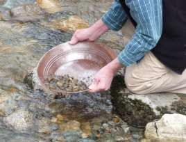
Panning for Gold in New Hampshire’s Streams
Obtaining permission from landowners is more than simple courtesy; you are extracting minerals that
are part of their property. Those gold panning may not use a shovel to dig into the stream bottom or
stream banks. Scooping gravel up with the gold pan is allowed. For those mineral seekers wishing to look
in the White Mountains, please visit the White Mountain Nation Forest (WMNF) website for more
information on regulations in the area. New Hampshire state lands, such as state parks, geologic and
historic sites, etc., have rules regarding mineral collecting. See: Administrative Rule Res 7301.19 – Res
7301.21 for more information.

Recreational Mineral Dredging
Dredging and the use of sluice boxes involves
disturbing the stream sediments but on a larger scale
than panning. Processing stream gravels in search of
placer gold, releases fine sediments back into the
stream. (Note the “muddy water” in the photo.)
Sediment-laden streams can be an environmental
issue. Therefore, certain regulations apply to this
activity in New Hampshire. Dredging and similar
operations are regulated by the state under statutes
RSA 482-A and RSA 485-A:17 because of the potential
for environmental damage.

Permit Required
Gold seekers who anticipate dredging, or similar work in New Hampshire, are required to obtain a
permit. The application for a permit to operate a minimum impact small motor dredge for recreational
mining of gold and other minerals under RSA 482-A and RSA 485-A:17 is available online through the
NHDES Wetlands Bureau.

One MUST obtain a permit and follow these regulations in dredging for gold in New Hampshire.
Recreational panners also need to check the regulations and everyone needs the permission of
landowners to access stream locations for panning or dredging. Detailed information regarding
permitting may be obtained by contacting the New Hampshire Department of Environmental Services
Wetlands Bureau, PO Box 95, Concord, NH 03302-0095; (603) 271-2147.

Where to Look for Gold in New Hampshire
Gold has been identified in placer deposits, quartz veins and in metamorphosed conglomerate,
especially the Clough Formation in the western side of the state. You can obtain a copy of the “Bedrock
Geology Map of New Hampshire,” 1997, (Geo-NHX-250000-BMAP), showing the location of these rock
formations, from NHDES’ Public Information Center, PO Box 95, Concord, NH 03302-0095; (603) 271-
8876; pip@des.nh.gov.

The most well-known New Hampshire gold deposits were described by C.H. Hitchcock in 1878, published
as the “Hitchock Atlas of New Hampshire Geology.” He identified the Ammonoosuc Gold District
centered on Lyman, Monroe and Bath, including southwestern Littleton, northwestern Landaff and
western Lisbon.

Smaller amounts came from the Diamond Ledge in Ossipee. Gold in the Ammonoosuc District is found in
veins (mineral filled cracks in the bedrock) with sulfide minerals such as pyrite, and as “free” gold in
quartz veins. Streams draining into the Connecticut River, especially from the confluence of the
                                                                                                         2
Ammonoosuc River at Woodsville north to the Connecticut Lakes, are all favorable for finding gold in
placer deposits. The Baker River, draining into the Merrimack River, is also reportedly favorable for
placer gold.
New Hampshire gold pieces in placer deposits range in size from very fine “specks” to pearl size
“nuggets.” In truth, hard work can probably produce traces of gold from many streams in the state. Gold
has been reported from many streams in northern and western New Hampshire. The following is a
partial list.
Town Stream
Benton Tunnel Brook
Lincoln Notch Brook
Lisbon Salmon Hole Brook (reported to be the site of an 1866 con scheme when a sluice box was
salted with gold to attract investors)
Wild Ammonoosuc River
Ammonoosuc River below Bath, NH
Northern Coos County Indian Stream (gold has been reported in glacial deposits in the area)
Perry Stream
Swift Diamond River
Resource Potential
The Ammonoosuc Mining District is part of a belt that continues out of Vermont, up the Connecticut
River, north into Quebec. This belt comprises of bedrock, which holds the highest potential in the state
for important discoveries of gold reserves, as well as other metals. This belt is defined by metamorphic
rocks, many of which were originally deposited as “volcanics,” which could have been, in part, endowed
with gold. The most intensive placer-recovery gold activity in recent years has occurred in surficial
deposits (soils and stream sediments) within this belt.
Other areas, including the rocks of the White Mountains and similar rocks to the south such as those
within the Pawtuckaway Mountains, are also favorable for gold prospecting. The potential also exists for
the occurrence of gold along faults, especially those rich in silica minerals.
As with any hobby, talking and working with other enthusiasts will give you a great deal of information
on locations and techniques. Additionally, New Hampshire has a number of active mineral clubs. An
online search can give you their contact information. Good luck!
If you have questions, contact the New Hampshire Geological Survey, 29 Hazen Drive, PO Box 95,
Concord, NH 03302-0095; (603) 271-1976; FAX (603) 271-3305; geology@des.nh.gov.
3Suggestions for Additional Reading
Boudette, E.L., 1990, The Geology of New Hampshire. Rocks & Minerals Magazine, v. 65, no. 4, p. 306-
312.
Heylmun, E.B., 1986, Ammonoosuc Gold District: California Mining Journal, (October issue).
Hitchcock, C.H., 1878, Geology of New Hampshire. Vol. 3: Part 3, surface geology; part 4, mineralogy and
lithology; part 5, economic geology; and atlas.
Jackson, C.T. 1844. Final report on the geology and mineralogy of the state of New Hampshire with
contributions toward the improvement of agriculture and metallurgy.
Meyers, T.R., and Stewart, G.W. 1956. The Geology of New Hampshire, part III, minerals and mines (with
1:500,000 scale map). http://des.nh.gov/organization/commissioner/pip/publications/geologic/geology.htm
Morrill, P. 1960. New Hampshire mines and mineral localities, 2nd ed., Hanover, NH, Dartmouth College
Museum, 46 p. (Reprints available from
http://www.barilbooksandminerals.com/Click%20Here%20to%20View%20Our%20Book%20Selection.ht
m)
Pearre, N.C., and Calkins, J.A. 1957. Mineral deposits and occurrences in New Hampshire, exclusive of
clay, sand, and gravel. U.S. Geological Survey, Mineral Investigations Resource Map 6.
The New Hampshire Geological Survey also has Mineral Publications and Aeromagnetic maps at
http://des.nh.gov/organization/commissioner/pip/publications/geologic/documents/geo_publ.pdf
4You can also read