I-435 North-South Corridor
←
→
Page content transcription
If your browser does not render page correctly, please read the page content below
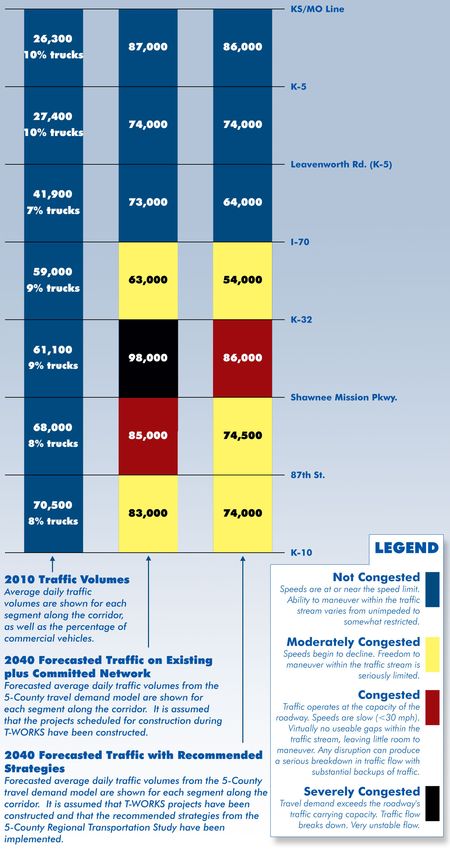
Figure 14-5: Traffic Volumes along I-435 North-South

I-435
North-South
Corridor

                                  Corridor
                                   Profile

                                 I-435
                              North-South

                        N

 Length: 19 miles

 Key Developments:
  Cerner
  Community America Ballpark
  Cricket Wireless Amphitheater
  Hollywood Casino
  KCI Airport
  Lenexa City Center
  Sporting Park
  Kansas Speedway
  Prairie Creek
  Schlitterbahn Waterpark
  Village West

 77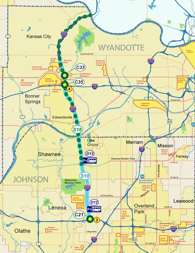
I-435 North-South Corridor

DESCRIPTION OF THE CORRIDOR                                     KEY DEVELOPMENT INFORMATION                                    I-435 access is sufficient to retail activity along Shawnee    CORRIDOR CONNECTIONS
I-435 is a primary north-south route from K-10 north to         While the overall roadway capacity of this section of          Mission Parkway and to the industrial development at 95th      Mainline I-435 does not show significant capacity
the Kansas/Missouri state line. North into Missouri, I-435      I-435 is sufficient, a primary concern is access to and from   Street and at Lackman Road. Decisions on Lackman Road          issues in 2040; however, near the I-70 and State Avenue
provides access to the Kansas City International Airport.       I-435 near Village West and the Schlitterbahn Water Park.      access at I-435 will be important to industrial development    interchanges, merging and weaving in that area could
This section of I-435 was opened in the mid-1980s and has       Existing development along the I-435 corridor includes         at this location. Access to the Lenexa City Center mixed-      cause problems. One concern is the weaving area on
supported growth and development in the corridor since          a large warehouse district in Lenexa, retail activity in       used development now being constructed at 87th Street          westbound I-70 between the I-435 ramps. The State
that time.                                                      Shawnee, and the Kansas Speedway and Village West in           will need to be addressed. This area will have large           Avenue and Parallel Parkway interchange configurations
                                                                Kansas City, Kansas.                                           amounts of new housing and employment development.             have been recommended for study to look for possible
The highway is a 6-lane roadway with interchanges that                                                                                                                                        modification to provide more capacity to access key
service east-west highways and major arterials.                 A number of the future major activity centers are located      High population growth on the Missouri side of the river       destinations. Similarly, access to the Lenexa City Center at
                                                                along this section of I-435. These include the City            along I-435 could impact traffic on the Kansas side of         87th Street may need to be addressed as that development
                                                                Center development on 87th Street in Lenexa, proposed          the river as these residents would likely cross the river to   occurs.
                                                                development on Johnson Drive, and expansion of the             access the Village West area development, as well as other
                                                                Village West area to include additional retail, office         employment and retail centers along the corridor.              The completion of the K-10 South Lawrence Trafficway
                                                                and recreational uses. The regional access provided by                                                                        will decrease the volume of traffic using the north-south
                                                                I-435 has been a catalyst for development. The future          TRAFFIC                                                        segment of I-435. Many of the trips currently using I-70
                                                                major developments will continue to need access to be          Traffic volumes are projected to increase along the            and I-435 for travel to and from the west of Lawrence and
                                                                successful. The Village West area continues to develop         corridor through the year 2040. Six lanes should continue      southern Johnson County will divert to K-10.
                                                                with an emphasis on automobile access. In general,             to provide sufficient capacity for most of this north-south
                                                                projected population and employment growth between             section of I-435. There is some congestion expected in         Similarly, if K-7 were reconstructed as a freeway between
                                                                I-435 and K-7, north of I-70, is very high. I-435 also         2040 between 95th Street and K-32. It is expected that six     I-70 and K-10, traffic would shift to this facility and
                                                                serves as major access to the KCI airport.                     miles of the 19 mile corridor will experience peak period      decrease the volume of traffic using I-435. If K-7 is not
                                                                                                                               congestion in the year 2040 between 87th Street and K-32.      converted to a freeway, it becomes significantly more
                                                                                                                               Both I-435 and K-7 show higher traffic volumes in the          congested and drivers will likely shift their trip to I-435.
 EXPANSION & MODERNIZATION T-WORKS PROJECTS CURRENTLY FUNDED                                                                                                                                  This change in travel behavior may also have an impact
                                                                                                                               northbound direction during the evening peak. When the
 FOR CONSTRUCTION                                                                                                              South Lawrence Trafficway is completed as a freeway            on east-west movement along K-10, Shawnee Mission
 In May 2010, the Kansas Legislature passed Transportation Works for Kansas (T-WORKS), an $8 billion 10-                       all the way around Lawrence, traffic volumes on K-7 and        Parkway and I-70 between the two corridors.
 year transportation program. T-WORKS is designed to create jobs, preserve highway infrastructure, and provide                 I-435 are expected to be reduced.
 multimodal economic development opportunities across the state. Table 14-8 lists the expansion and modernization
 projects that are funded through T-WORKS along the I-435 North-South corridor.
                                                                                                                               OTHER MODES
 Table 14-8: T-WORKS Expansion and Modernization Projects Currently Funded for Construction                                    Multimodal opportunities that are currently being explored
                                                                                                                               in the Village West area include developing a Park & Ride
   Project                                                                                     Construction   Planned
   Number
                            Location                              Description
                                                                                                  Cost          Year
                                                                                                                               lot and a bus rapid transit (BRT) route with a number
                                                                                                                               of transit stops. To be effective, site plans need to orient
                   I-435/I-35/K-10 Interchange
                     (Johnson Co. Gateway)
                                                   2nd Phase - Construct C-D roads and ramps     $250 M        2014
                                                                                                                               development to enhance transit access.

                   I-70 from I-435 to State Line       I-70 Real Time Traveler Information      $621,000       2012

                                                                                                                                                                                                                                                   78
RECOMMENDED STRATEGIES Stakeholders determined that the 9 Desired Outcomes congestion ahead. This strategy is used to slow traffic travelers to use personal vehicles for errands either before
The continued maintenance and operation of existing should be used in making transportation investment before it reaches the congested area and to better allow that or after their commute to work.
roadways and transit services must occur before other decisions. The total score for each strategy was congestion to dissipate.
strategies are implemented on the I-435 corridor. determined by multiplying the individual outcome score by D26: Bicycle and pedestrian facilities should be
a weighting factor that was established by stakeholders for S18: Expand the KC Scout intelligent transportation considered on all new or renovated bridges over I-435.
A variety of strategies were considered to improve current that desired outcome. The total cost is given in year 2020 system (ITS) from Kansas/Missouri state line to
and future traffic operations on I-435 through the year dollars and includes the construction/ implementation cost Midland Drive. The ITS devices would include dynamic Increased Capacity Strategies
2040. These strategies are shown in Table 14-9. Strategies and 10 years of maintenance/operation cost. The Benefit message signs to warn drivers of upcoming travel These strategies increase the traffic-carrying capacity of
that are recommended as part of a corridor package are Ratio was determined by dividing the Total Score by the conditions and a camera system to monitor the real-time a roadway through adding lanes, modifying interchanges,
shaded in blue; strategies that were not recommended Total Cost in $millions. flow of traffic. and constructing new roadways.
during the 2020 to 2040 timeframe are not shaded. Each
strategy was assigned an identifier code of a letter and System Management Strategies Demand Management Strategies C21: Construct the remaining phases of the I-435/I-
number that are shown on the I-435 corridor map. An “S” These strategies seek to enhance traffic flow and reduce These strategies address transportation needs by reducing 35/K-10 Johnson County Gateway interchange.
indicates a system management strategy, a “D” indicates congestion through better management and operation of the number of vehicles during the peak travel periods.
a demand management strategy, and a “C” indicates an the existing transportation facilities. C33: Reconfigure the I-435 and State Avenue
added capacity strategy. D12: Construct a Park & Ride facility near the interchange.
S10: Implement variable speed limits from Parallel Shawnee Mission Parkway interchange and near the
The table shows how each strategy scored for the criteria Parkway to K-10. Variable speed limits can reduce 95th Street interchange. Park & Ride facilities promote C35: Add a “fly-over” ramp for the northbound to
used to evaluate each of the 9 Desired Outcomes. the speed limit on I-435 when there is considerable carpooling and transit use while offering the flexibility for westbound traffic movement at the I-70 and I-435
interchange.
Table 14-9: I-435 North-South Corridor Strategy Package
Recommended Corridor Strategies and Evaluation Scores
Desired Outcomes (weighting factor***) Total Total Cost Benefit Decade
Score ($millions)* Ratio**
Engineering Economic Impact Community Impact
Mobility Safety Regional Financial Choice Environ- Public Social Livability 2020- 2030-
(15.5) (16.0) Prosperity Resources (8.5) ment Health Equity (9.0) 2030 2040
Strategies (12.5) (15.0) (9.0) (7.0) (7.5)
Operate and maintain existing roads, bridges, transit service, ITS, traffic signals, X X
incident management
S10 Variable Speed Limits from Parallel Pkwy to K-10 4.5 4.4 3.3 10.0 3.3 4.1 3.6 4.4 3.3 482 1.5 318.8 X
D12 Construct Park & Ride facilities near Shawnee Mission Parkway, and near 95th St. 4.4 3.3 3.3 6.0 5.0 4.5 3.8 5.0 5.5 448 1.5 304.5 X
C21 Construct remaining phases of I-435/I-35/ K-10 Gateway project 6.2 5.0 5.0 3.4 3.3 3.6 4.4 4.4 2.6 437 310.8 1.4 X X
S18 Expand KC Scout ITS System from KS / MO state line to Midland Drive 4.3 6.5 3.3 4.4 3.3 3.6 4.2 4.4 3.3 430 2.2 195.2 X
C32 Active lane use control including "hard shoulder running" and potential HOT or 4.9 3.7 3.7 3.5 5.0 4.5 4.5 5.0 3.6 421 58.8 7.2
HOV lane during peak hours from K-10 to I-70
C33 Reconfigure the I-435 and State Avenue interchange 4.8 4.4 3.7 5.1 3.3 3.6 3.6 4.4 3.3 416 10.5 39.6 X
D26 Bicycle/pedestrian facilities: consider on all new or reconstructed bridges over I-435 3.8 3.7 3.3 4.1 5.0 4.1 3.9 5.0 5.5 414 1.6 263.1 X
C35 Add fly over ramp northbound to westbound on I-70 and I-435 interchange 5.0 5.6 3.7 3.4 3.3 3.3 3.9 4.4 3.3 412 52.5 7.8 X
C42 Reconfigure I-435 and Parallel Parkway interchange 4.5 4.4 3.7 4.2 3.3 3.6 3.6 4.4 3.3 398 15.8 25.3
C38 Reconfigure I-70 & I-435 interchange 4.6 4.4 4.4 3.4 3.3 4.5 4.2 4.4 3.3 407 210 1.9
D49 Parallel bicycle / pedestrian trail development as specified in the MARC Metro 3.3 3.3 3.3 3.4 5.0 4.1 3.8 5.0 5.0 381 8.4 45.4
Green plan / local plans
Recommended Strategy
*Total Cost is in 2020 dollars and includes costs for constructing/implementing the strategy and 10 years of operation and maintenance costs.
**Benefit Ratio is determined by dividing the Total Score of the strategy by the Total Cost in $millions. It provides a way to compare strategies.
***The numbers in parenthesis below each Desired Outcome indicate the weight assigned as determined through stakeholder input.
79You can also read