Brackenridge Park Master Plan First Draft - April 26, 2016 City of San Antonio Transportation & Capital
←
→
Page content transcription
If your browser does not render page correctly, please read the page content below
Brackenridge Park Master Plan
         First Draft
                      April 26, 2016

      City of San Antonio
    Transportation & Capital
         Improvements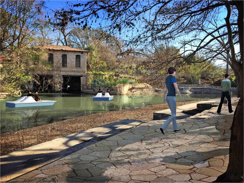
Brackenridge Park Master Plan
         First Draft

                                    +

   Pape-Dawson Engineers   Raba-Kistner
   Adams Environmental     Ann Benson-McGlone
   TetraTech               Marek-Hill Design
   CNG Engineering         AG/CM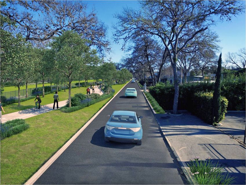
What are the major issues?
The park is perceived as
a collection of parts
rather than as a whole

Goal: Integrate the park into its
surroundings and clarify the
park perimeter

Strategy: Develop a common
hardscape and landscape theme/
design for edges of all portions of
the park (fee and non-fee)
Pedestrian connections
to surrounding
neighborhoods, traffic
arteries, and other
areas are weak

Goal: Integrate the park into its
surroundings and clarify the park
perimeter

Strategy: Create a better
pedestrian environment between
neighborhoods and the park and
improve crossings at major
streets
Traffic and parking
 dominate
 the natural landscape

Goal: Strengthen the historic
north-south organization of the
park along the river by creating a
series of pedestrian-focused spaces
along the river

Strategy: Rethink the parking and
traffic strategy by eliminating
portions of interior roads and
pushing parking to the perimeter;
rededicate land to public space
Lack of parking and
constricted roadway
access for major
attractions and events
is a growing issue

Goal: Reduce traffic and parking
impacts on the park

Strategy:

• Add parking structures to the
  park perimeter through public/
  private joint ventures

• Employ reinforced turf for
  overflow parking conditions

• Consider land acquisition
Natural habitat in the park
is diminished by man-made
elements, or by invasive
plants and animals

 Goal: Restore the character of natural
 areas

Strategy:

• Use modern drainage design
  techniques to naturalize the
  aesthetic of flood control

• Incorporate pedestrian access to
  bank edges
Bank erosion along the
river and water quality are
significant issues
Goal: Restore the character of natural
areas

Strategy:

• Strive to improve water quality to a
  level that would support human
  contact.

• Stabilize river banks using current
  engineering technology to naturalize
  those environments at the same time
Only a third of the park
is available for
unscheduled free use

Goal: Balance active, passive,
and cultural uses of the park

 Strategy:

 • Over time repurpose large
   portions of the park from
   single-user activity to multi-
   activity focused space

 • Where possible blur the lines
   between fee and non-fee use
   areas

 • Reclaim surface parking lots
   for green space
Maintenance, operations,
and programming of park
assets is difficult and
expensive

Goal: Create community support for
the well-being of the park

Strategy:
• Through a private entity, develop
  mechanisms to fund on-going
  O&M outside of, or in addition to,
  the COSA general fund
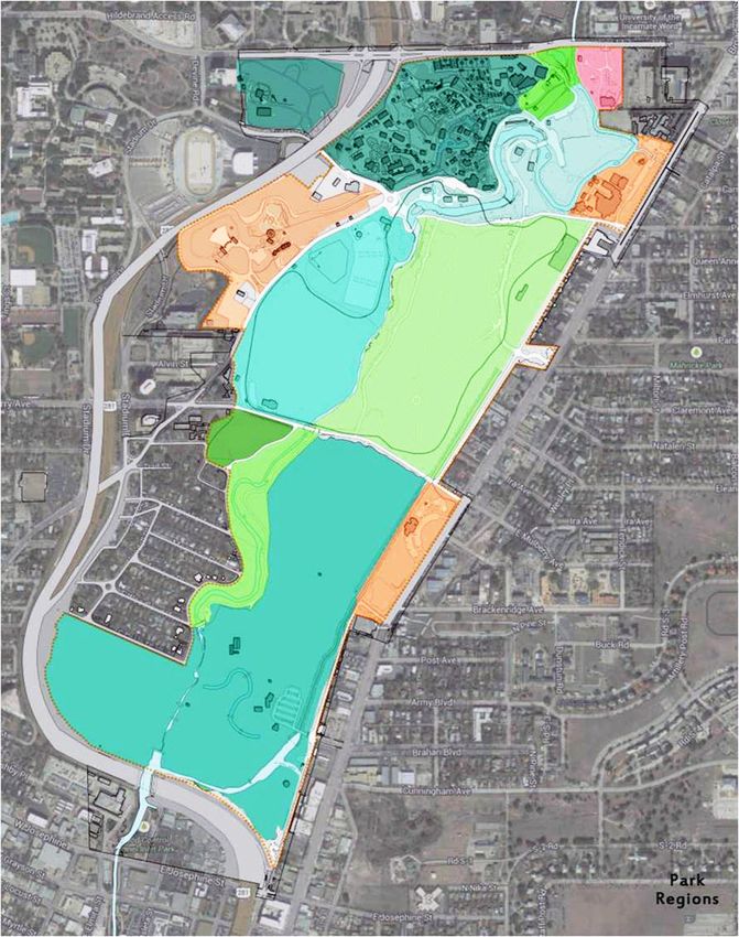
Section 2
   Physical Plan
Area #1 – North End History
and Walking Area

Area #2 – Heart of the Park

Area #3 – Wilderness Area

Area #4 – Sunken Garden
Theater/Japanese Tea
Garden

Area #5 – Golf Course and
Southern Areas
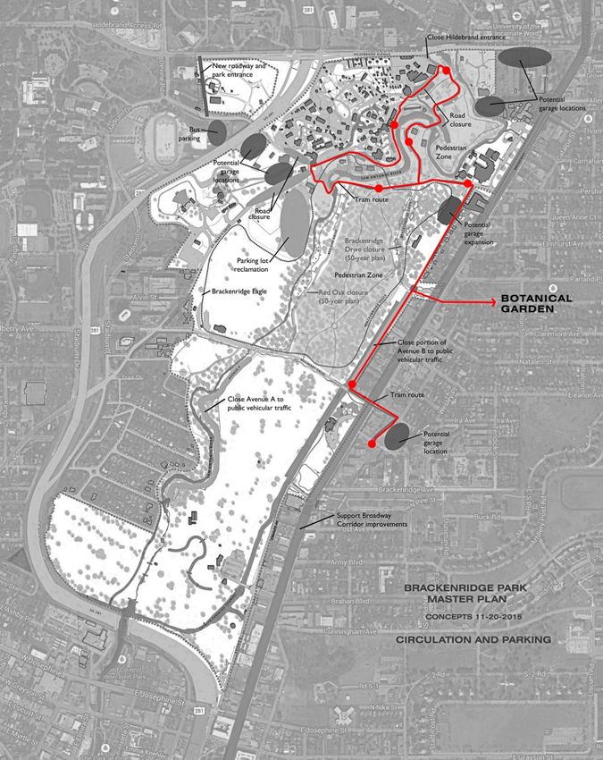
Area #1 – North End History
and Walking Area

General Improvements:

• Remove traffic (asphalt)
  from the area

• Close Hildebrand Entrance
  except for Zoo service

• Create multi-use paths to
  allow walkers, leisure
  bikers, and a motorized
  people mover
Area #1 – North End History
and Walking Area

General Improvements:

• Create an amphitheater for
  educational events and
  incorporate Civil War era
  sluce recovered from
  previous archeological
  exploration

• Interpret multiple layers of
  history through (Upper
  Labor Dam, SA Waterworks
  features, etc.)the built
  environment and signage

• Extend a path north under
  Hildebrand to connect the
  park to the “Blue Hole” and
  the Headwaters at
  Incarnate Word
North End History and Walking Area
Area #1 – North End History
and Walking Area

Lambert Beach

• Improve water quality

• Repurpose historic
  buildings to support park
  user needs

• Remove earth road bridge
  from pump house face and
  replace with pedestrian
  bridge that was original to
  the park

• Introduce water activities
  allowable as water quality
  improves (paddle boats,
  etc.)
Lambert Beach Back to Historic Use
New
  Image
  Here


                                  Area #1 – North End History
                                  and Walking Area

                                  Miraflores Connection

                                  • Honor the Master Plan
                                    already created for the
                                    Miraflores property

                                  • Existing footbridge links
                                    Miraflores to the park
New
Image
Here
Area #1 – North End History
and Walking Area
Additional Parking
• Participate in the
construction of a joint-use
parking garage northeast of
the park on private
property. This facility could
benefit the land owner, park
users, and the University of
the Incarnate Word
• Provide access from the
parking garage to
Miraflores and the park
• Create multi-use path to
include circulator tramArea #1 – North End History and Walking Area • Create multi-use path to include circulator tram
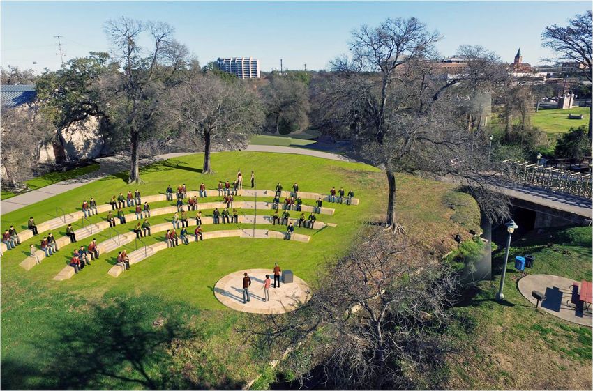
Area #2 – Heart of the Park
• A focused public space for
  major events and daily
  recreation that is
  synergistic with Sunken
  Garden Theater and
  Japanese Tea Garden
• Remove parking
• Relocate train station and
  concession adjacent to zoo
• Provide safe connections
  from the Grand Lawn to the
  San Antonio River
• Future consideration:
  relocate Martinez softball
  field to make a more grand
  space
• Develop utility
  infrastructure to support
  events
Grand Lawn Before
Grand Lawn
New
Image
Here
Area #2 – Heart of the Park
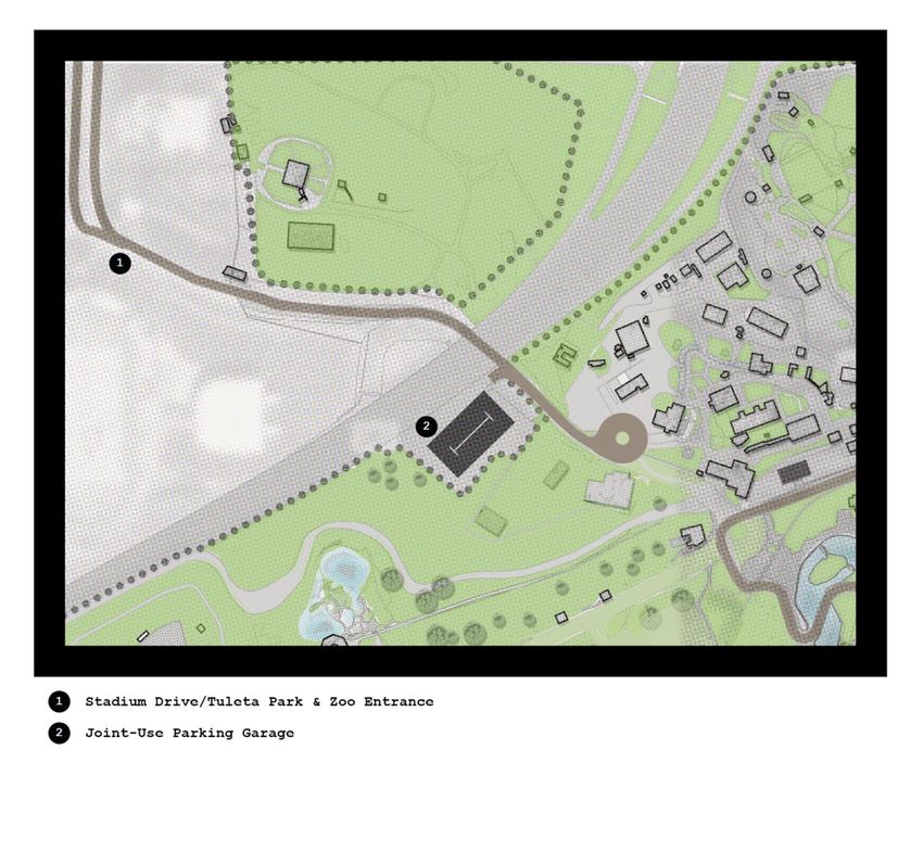
• Emphasize US Highway
281/Hildebrand exits as
main access to SA Zoo and
Brackenridge Park
• Create a grand entrance
plaza at the zoo; re-purpose
Stadium Drive and the
north end of Tuleta as the
park and zoo entranceStadium Drive/Tuleta Entrance - Before
Stadium Drive/Tuleta Entrance
Area #2 – Heart of the Park

• Close Tuleta just past the
  Paul Jolly Center for Pet
  Adoption

• Create a bus drop off and
  turn around for the zoo

• Negotiate a joint use
  agreement with SAISD for
  the use of surface parking
  lot for bus staging (Zoo,
  Witte, and DoSeum)

• Close St. Mary’s Street just
  north of the “Mexican
  Village” below the Japanese
  Tea Garden
New
Image
Here
Area #3 – Wilderness Area
San Antonio River and
Catalpa Pershing Channel
• Restore the San Antonio
River channel
• Restore the Catalpa-
Pershing Channel to a more
natural state
• Manage invasive species
• Continue to convert
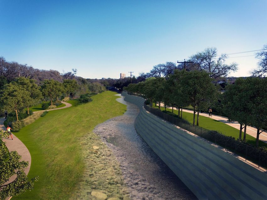
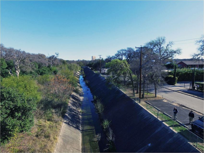
roadways to multi-use pathsCatalpa-Pershing Channel - Before
Catalpa-Pershing Channel
New
Image
Here
Area #3 – Wilderness Area
Broadway Connections and
Avenue B
• Create at least two corridor
connections between
Broadway and the Catalpa-
Pershing Channel (via land
acquisition)
• In those corridors develop
generous walkways, public
art, lighting, and
appropriate planting
• Develop Avenue B as a one-
way northbound park road
allowing access for existing
driveways.
• Create a meandering multi-
use trail between the road
and the Catalpa-Pershing
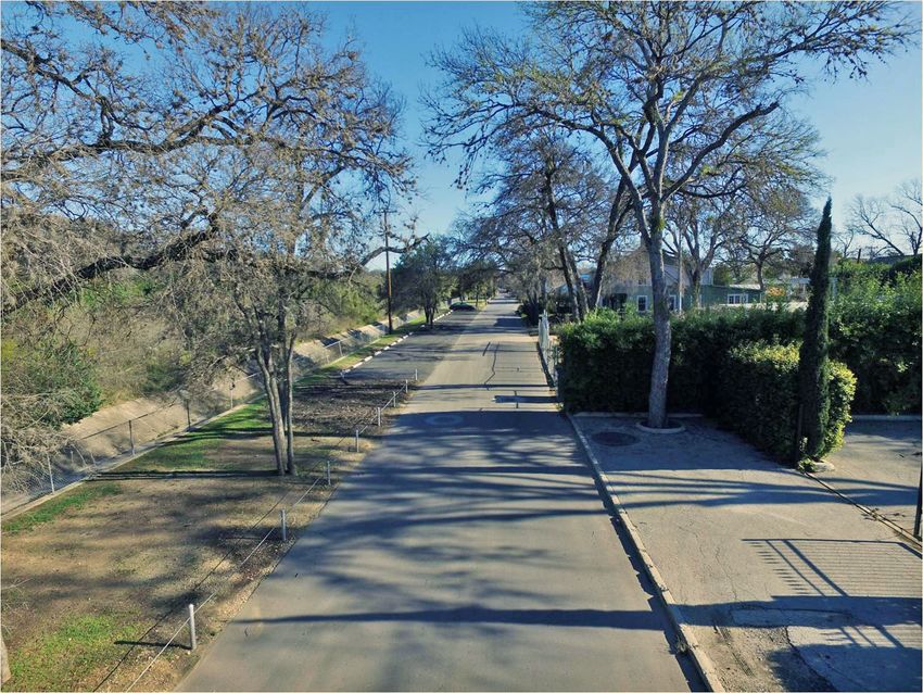
ChannelAvenue B-Mulberry to Brackenridge - Before
Avenue B – Mulberry to Brackenridge
New
  Image
  Here


                                  Area #4 – Sunken Garden
                                  Theater and Japanese Tea
                                  Garden

                                  • Identify an organization to
                                    sponsor the renovation of
                                    Sunken Garden Theater

                                  • Implement a full renovation
                                    of the theater

                                  • Develop a year-round event
                                    calendar for the theater

                                  • Partner with other entities
                                    to resolve traffic and
                                    parking issues
New
Image
Here
Area #4 – Sunken Garden
Theater and Japanese Tea
Garden
• Almost 1,800 parking
spaces available within
walking distance.New
Image
Here
Area #5 – Brackenridge Park
Golf Course and Southern
Areas
• No major changes to the golf
course are proposed in this
plan, except the continued
improvement to perimeter
fencing in keeping with
recent SARIP installations
• SA River channel
restoration
• Catalpa-Pershing Channel
restoration (include Lion’s
Field connection/access)
• Continue improvement to
Avenue B
• All multi-use paths should
connect south to the
Museum Reach SARIPNew
Image
Here
Area #5 – Brackenridge Park
Golf Course and Southern
Areas
• DoSeum has enlarged the
perceived boundaries of the
park district
• Connect the DoSeum to the
park by including it on the
route of the people mover
• Support the development of
a parking garage that would
be sited partly on DoSeum
property and partly in the
right-of-way of Margaret
Street
• Include the DoSeum and
Botanical Garden in the
joint bus staging plan with
SAISDArea #5 – Brackenridge Park Golf Course and Southern Areas • Convert Avenue A to multi- use path with limited golf course service access • Existing low water crossing upgraded to allow pedestrian access from River Road neighborhood to park
You can also read