Weekly Fire Danger Assessment NCFS - Region II - For Time Period: Saturday (3/4/23) to Friday (3/10/23)
←
→
Page content transcription
If your browser does not render page correctly, please read the page content below
Weekly Fire Danger Assessment
       NCFS - Region II

              For Time Period:
    Saturday (3/4/23) to Friday (3/10/23)

                                            Created by: Jamie Dunbar
                                            Fire Environment Staff Forester
                                            NC Forest Service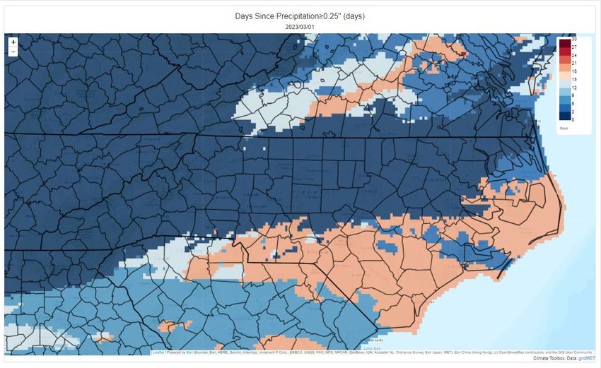
Past Week’s Signal 14 Activity

                                                              NCFS - Region 2
                                    Previous 7-Day Fire Activity (Does Not Include Federal Ownerships)
                    Data Source:           Signal 14 Regional Activity Summary Report (Signal 14 is a snapshot in time)
                    Date Range:                                       2/24 - 3/2, 2023

                                     Type                    Number                              Acres
                                  Wildfires:                                                69                            149.9
                               Prescribed Fires:                                            51                            3670

fiResponse Incident Location Map (for general context)
Date Range: 2/24 – 3/2, 2023
Report: Business Intelligence Module, Response Trends Map

                                                                                                                                  Legend by Size
                                                                                                                                   Class Range
                                                                                                                                      (acres)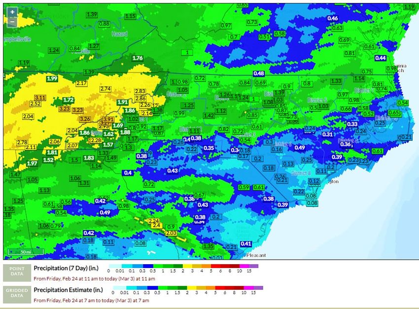
Weather Outlook Discussion

     RAL – NWS Office, Forecast Discussion Notes from 3/3/2023 PM

     Conditions will dry out on Saturday as surface high pressure builds
     east from the central Plains to the TN Valley. West to northwest
     surface winds will be breezy throughout the day as Friday`s cold front
     exits, and high pressure builds in. Gusts of 25-35 mph are expected,
     mainly across the northern half of central NC. Winds will be strongest
     in the morning, and slowly diminish throughout the day.

     The extended period will begin with mostly sunny skies and dry weather
     on Sunday and Monday as mid/upper ridging builds over the Southeast
     US. At the surface, high pressure will initially be centered over the
     Carolinas on Sunday, then shift offshore on Sunday night/Monday. So,
     while temperatures on Sunday will be about 5-10 degrees above normal
     (highs in the mid-60s to near 70 and lows in the upper-30s to lower-
     40s), they will become even warmer on Monday (upper-60s to mid-70s)
     with SW return flow around the offshore high.

     Forecast confidence decreases for the rest of the period, as there is
     still a lot of uncertainty with how a shortwave trough that looks to
     be located somewhere over the Intermountain West on Wednesday/Thursday
     will ultimately track and evolve.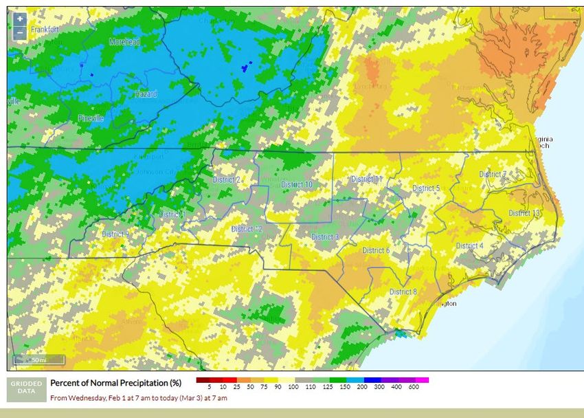
ENSO Note

  •    Weak La Nina conditions still present.

  •    Still favors transition to ENSO-Neutral and potentially El Nino into the
       late Summer of 2023.

Slide Source: https://www.cpc.ncep.noaa.gov/products/analysis_monitoring/lanina/enso_evolution-status-fcsts-web.pdf
WPC Forecasted Surface Fronts & Sea-Level Pressures
             Saturday - 700 am               Sunday - 700 am                        Monday - 700 am

             Tuesday - 700 am               Wednesday - 700 am                     Thursday - 700 am

                                                                 Friday - 700 am

Location: https://www.wpc.ncep.noaa.gov/#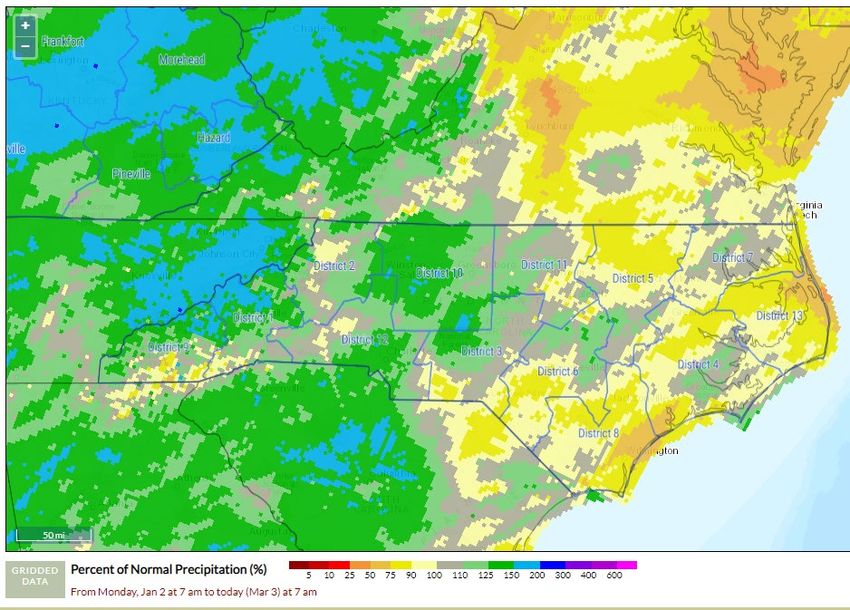
Quantitative Precipitation Forecast, 7-Day
                  Day - 1                   Day - 2   Day - 3

                  Day - 4                   Day - 5    Day - 6

                                                           Day - 7

Location: https://www.wpc.ncep.noaa.gov/#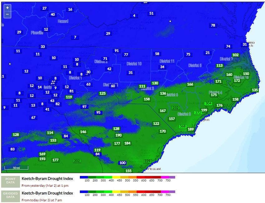
Temp & Precip Outlook
     6-10 Day, 8-14 Day & Week 3-4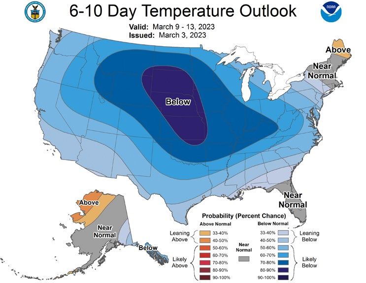
7 Day Precipitation Totals
      FWIP (Point accumulation ending at 1100 on 3/3, Grid ending 0700 3/3)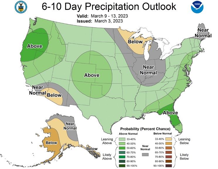
Departure from Normal Precip, FWIP
    30-Day % of Normal                        60-Day % of Normal

                         90-Day % of Normal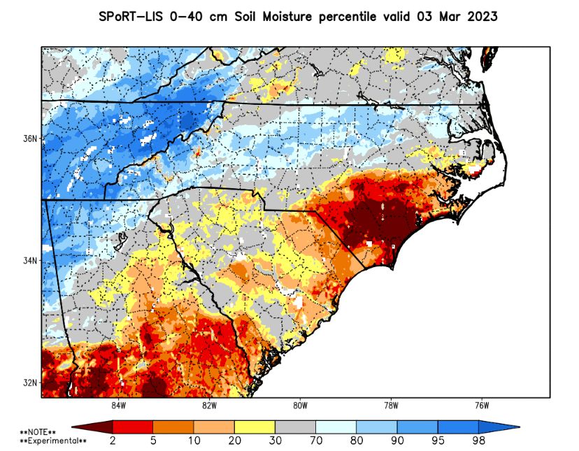
Drought Situation
                  Previous Week:

                                      Current Week:

                                                      • Favoring Drought Expansion if
                                                        lack of significant rain continues
                                                        with green-up (focus East)
                                                      • 7-Day Stream flow averages also
                                                        decreasing East

Source: https://www.ncdrought.org/map-archives
Significant Wildland Fire Potential Outlook: Updated 3/1/23 A significant fire is one that requires resources from outside the district (other than aviation). IA potential is based more on shorter term weather factors. Just a few days of dry weather can increase IA activity considerably as we have already seen this year.
SPoRT Relative Soil Dryness

                                                                       • Drying Trend 0-2 Meter Depth,
               0-40 cm Depth (Shallow Dryness)                           especially to the East & South

                                                                               0-200 cm Depth

Source: https://weather.msfc.nasa.gov/sport/case_studies/lis_NC.html
KBDI - Gridded & Station Points (FWIP)
Days Since Daily Precip ≥ 0.25” • Note – Latest product run was on 3/1/23
not considering rainfall after that point.
Climate Toolbox Link:
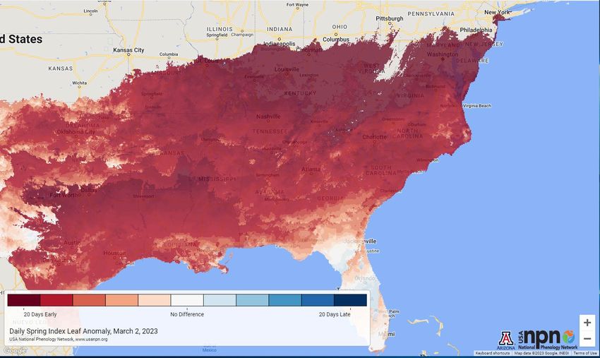
https://climatetoolbox.org/tool/climate-mapper?product=fire&variable=dsp_0.25&mapMin=0&mapMax=21&opacity=0.7&colorPalette=invBrBG&numColors=11&outOfBoundsColor=extend&baseMap=World_Topo_Map&mapZoom=8&mapCenterLat=35.42934&mapCenterLon=-79.20044Green Fraction & Green-Up Anomaly
• Generally, 2-3 Weeks Ahead of 30-Yr Avg
• Risk of Frost/Freeze Concerns Later in
March
Link: https://weather.msfc.nasa.gov/cgi-bin/basicLooper.pl?category=lis_NC&initialize=first®ex=gvf_20230228Current and Forecasted Fire
Danger Conditions by FDRA
R2Regional Comments
• Rain events have kept the majority of the Region 2 fire activity to a
normal fire season.
• The sandhill areas are the driest area but have seen normal fire
activity.
• Early Spring could lead to drying out of top layer of duff/soil.
• 100-hr fuel moistures are at average seasonal values.
• Short lived low RH/Wind event have/can create an increase in fire
activity at a local County level.Important notes for next slide group:
A. Current ERC, 100-Hr & 1000-Hr values are extracts from FF+ using observation data
downloaded from WIMS.
B. Weekly Outlook - FDRA General Fire Danger Forecast Matrix:
1. The matrix is an adaption of the existing Weekly NCFS Region-3 Fire Danger Assessment Matrix Process.
• Matrix exposes existing available data in the same fashion, but on all 9 FDRAs.
• Uses Fire Danger Adjective Rating Concept – Grouped into three bins (see notes on 3 & 4 below).
• Weather variable ranges were defined by FDRA stakeholders and relate to Pocket Card notes.
• Is in development, with goal being to have this as another tool on FWIP with daily automated updates.
2. The forecast matrix was created from standard NFDRS Forecast Outputs.
• 7-Day Forecast Cycle from NWS using NFDRS Observations & Outputs generated from SIG Stations in FDRA
3. Fire Danger Forecast Indices/Component Values are grouped into three categories:
• Low to Moderate (0-74th Percentile); shown in Blue-Green
• High (75th-89th Percentile) – shown in Yellow
• VH to Extreme (90th+ Percentile) – shown in Red, called Critical
4. Dead Fuel Moisture Forecast Values are grouped into three categories:
• Low to Moderate ( 26th-100th Percentile); shown in Blue-Green
• High (11th-25th Percentile); shown in Yellow
• VH to Extreme (0-10th Percentile) – shown in Red, called Critical
5. Other Notes:
• **Read the Key and Notes associated with each FDRA (included with matrix image).**
• Forecasts are variable and can change.
• Is another tool for gaining better situational awareness by exposing the data in an easier to digest format.
• Feedback is appreciated.Region Specific – Blue Ridge Escarpment
Region Specific – Western Piedmont
Region Specific – Eastern Piedmont

       Note: *Database Issue – Unable to generate FF+ Output for Eastern
                 Piedmont FDRA at time of Friday PM release.
Region Specific – Sandhills
Region Specific – South Coast
You can also read