WETLANDS IN THE GREAT BARRIER REEF CATCHMENTS Management Strategy 2016-21 - WetlandInfo
←
→
Page content transcription
If your browser does not render page correctly, please read the page content below

Department of Environment and Heritage Protection

WETLANDS
IN THE GREAT BARRIER REEF CATCHMENTS
                     Management Strategy
                                                     2016–21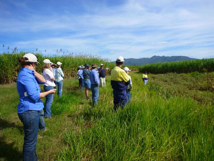
Prepared by: Wetlands Team, Department of Environment and Heritage Protection
© State of Queensland, 2016.
The Queensland Government supports and encourages the dissemination and exchange of its information. The copyright in this publication
is licensed under a Creative Commons Attribution 3.0 Australia (CC BY) licence.
Under this licence you are free, without having to seek our permission, to use this publication in accordance with the licence terms.
You must keep intact the copyright notice and attribute the State of Queensland as the source of the publication. For more information on
this licence, visit http://creativecommons.org/licenses/by/3.0/au/deed.en

Disclaimer
This document has been prepared with all due diligence and care, based on the best available information at the time of publication.
The department holds no responsibility for any errors or omissions within this document. Any decisions made by other parties based on this
document are solely the responsibility of those parties. Information contained in this document is from a number of sources and, as such,
does not necessarily represent government or departmental policy.
If you need to access this document in a language other than English, please call the Translating and Interpreting Service
(TIS National) on 131 450 and ask them to telephone Library Services on +61 7 3170 5470.

This publication can be made available in an alternative format (e.g. large
print or audiotape) on request for people with vision impairment; phone
+61 7 3170 5470 or email .
June 2016
#31086

2

Minister’s foreword                                                        Contents
The Queensland Government is committed to ensuring that the                Minister’s foreword............................................................. 3
Great Barrier Reef is conserved for future generations. While the
corals that build reefs are among the most visible natural value in        Key messages..................................................................... 4
the reef ecosystem, the broader reef ecosystem and the catchments
that connect to it are as important for maintaining the health             Introduction........................................................................ 4
and resilience of the reef. This broader reef ecosystem includes               Vision.............................................................................. 6
mangroves, seagrasses and inshore coral reefs, as well as adjacent             Purpose........................................................................... 6
freshwater wetlands.
                                                                               Context............................................................................ 6
The Reef 2050 Long Term Sustainability Plan recognises the value               Wetland values and services............................................ 8
of wetlands in contributing to reef resilience and ecosystem health,
                                                                               Wetland pressures........................................................... 8
and highlights that there has been a decline in ecosystem processes
that are important for maintaining water quality. The quality of water     Managing wetlands ............................................................ 9
entering the Great Barrier Reef from adjacent catchments remains a
major management issue. In response to ongoing concerns regarding              Whole-of-system catchment management framework...... 10
water quality, the government has set ambitious targets to reduce          Themes............................................................................... 13
land-based runoff of pollutants. It has also committed to targets aimed
at no net loss of natural wetlands and an improvement in the ecological        Theme 1: Improving wetlands information for
processes and environmental values of wetlands in recognition of the            decision making and action............................................ 13
important role they can play in catchment and reef health.                     Theme 2: Wetland planning arrangements....................... 15
The Queensland Government established the Office of the Great                  Theme 3: On-ground activities to protect, manage
Barrier Reef to coordinate and implement reef management strategies            and rehabilitate wetlands................................................ 17
and programs. Additionally, the government convened the Great                  Theme 4: Education, communication and
Barrier Reef Water Science Taskforce to provide independent advice to          capacity building............................................................. 19
ensure that clean water flows from the rivers to the sea to protect the        Theme 5: Monitoring, evaluation, reporting
reef. There is increasing recognition that previous initiatives are not        and improvement............................................................. 21
sufficient to meet the water quality targets for the Great Barrier Reef.
The Great Barrier Reef Water Science Taskforce also recognised that        Governance......................................................................... 23
the health of the catchments and wetlands of the Great Barrier Reef are
critical to its resilience. Their recommendations included improving       Next steps .......................................................................... 23
the protection and health of wetlands and coastal ecosystems and
rehabilitating wetlands and coastal ecosystems.
The Wetlands of the Great Barrier Reef Catchments Management
Strategy 2016-2021 sets out a framework for the improved
management of the wetlands of the Great Barrier Reef catchments.
It builds on the achievements of the Queensland Wetlands Program
and recognises wetlands as vital to the health of the Great Barrier
Reef ecosystem and its catchments.
This strategy includes five themes: improved information; planning;
on-ground management; communication and education; and
evaluation, review and improvement. Wetlands, catchments and the
Reef are interconnected and a healthy reef is dependent on effective
management and wise use of wetlands and their catchments.

Dr Steven Miles MP
Minister for Environment and Heritage Protection
and Minister for National Parks and the Great Barrier Reef

                                                                                                                                                                        3
Key messages
    • This strategy promotes an integrated approach to catchment management that considers the multiple values of wetlands in a whole-
      of-catchment context.
    • Wetlands play numerous roles across the land and seascape including connecting many species to the Reef and also filtering
      catchment runoff. Wetlands provide protection from wave action and storms, reduce the impacts of floods, as well as provide habitat.
    • Not all wetlands deliver all values and services. For example, some wetlands play a crucial role in improving water quality, while
      other wetlands are important for their biodiversity values. A range of factors influence what values and services a wetland provides
      including its location, size, type and its state. There are legislative and policy drivers that affect what values are considered
      important from a societal perspective. The challenge for management decisions regarding wetlands is to achieve a balance between
      competing interests.
    • Threats to wetlands are numerous and can be located some distance from the wetland itself. Many wetlands have been extensively
      modified or lost over the last 100 years and their rehabilitation in strategic locations will contribute to water quality improvement
      and the provision of other wetland values and services.
    • A large amount of information and tools are available to assist with managing wetlands. Wetlands occur on public and private land
      and looking after them is a collaborative effort across all levels of government and non-government stakeholders. This strategy
      establishes the actions needed for wetlands to contribute to the targets of the Reef 2050 Long Term Sustainability Plan and the Reef
      Water Quality Protection Plan 2013.

Introduction
Wetlands and coastal ecosystems in the catchments of the reef provide a vital role in protecting shores from wave action and storms,
reducing the impacts of floods, retaining sediment, absorbing and transforming pollutants and providing nurseries for fish and other
freshwater and marine species. Swamps, rivers, billabongs, lakes, mudflats, mangroves, farm dams and groundwater systems are all
examples of wetlands. In fact, not all wetlands are wet all the time, for example paperbark woodlands can dry out completely. Wetlands are
made up of many parts that interact with the surrounding environment to create functioning ecosystems. These, in turn, provide important
ecosystem services that are valued by the community. Without active planning and management, changes to these habitats will continue to
result in the loss of many of their values.
While there are over 15,000km2 of wetlands remaining in the catchments of the Great Barrier Reef, many wetlands and coastal ecosystems
have been extensively modified or lost over the last 100 years. Their restoration and rehabilitation in strategic locations will contribute to
water quality improvement and the enhancement of other wetland values.
Grazing is the major land use covering 74% of the catchments of the reef, while intensive agriculture (predominantly sugarcane farming)
occurs in lower coastal floodplains comprising 5% of the total catchment area. These land uses have resulted in extensive loss of freshwater
wetland and forested floodplain ecosystems in some locations. Intensification and expansion in the agricultural sector has the potential to
lead to further decline in wetlands extent and health.
The Great Barrier Reef catchments area includes the river basins that flow eastwards into the Coral Sea from the Great Dividing Range and
incorporates six broad management areas—Cape York, Wet Tropics, Burdekin Dry Tropics, Mackay-Whitsunday, Fitzroy and Burnett-Mary
(Figure 1). Within these management areas there are 35 river basins (smaller catchments) covering an area of approximately 423,000km².
The inter-dependencies between catchments, wetlands and the broader reef ecosystem underpin this strategy’s whole-of-system catchment
management approach for the improved management of wetlands. The strategy provides the strategic approach needed to achieve the goal
of no net loss of natural wetlands and that wetland values and ecological processes are enhanced, thereby contributing to the health and
resilience of the Great Barrier Reef. This strategy presents the policy drivers that inform action, the values and pressures on these wetlands
and coastal ecosystems, and outlines management actions within five themes.

4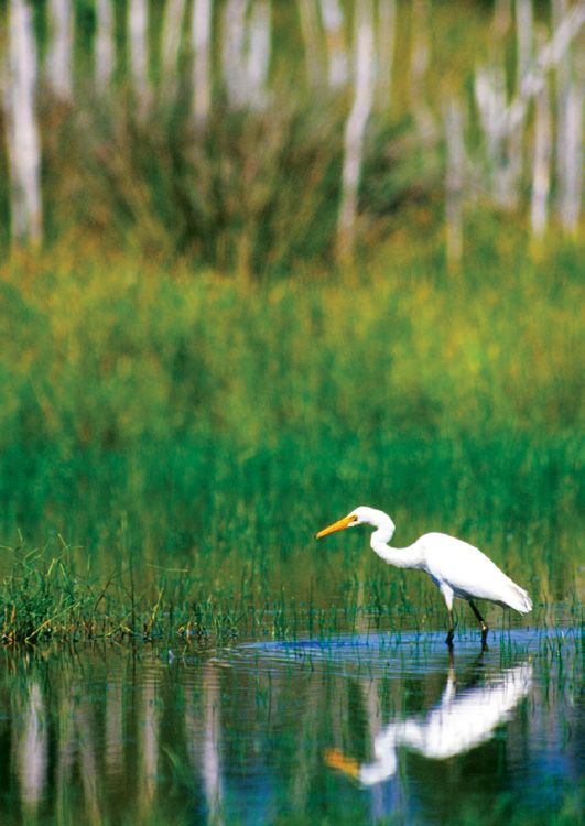
Figure 1 Great Barrier Reef regional Natural Resource Management (NRM) area boundaries—Cape York,
Wet Tropics, Burdekin Dry Tropics, Mackay Whitsunday, Fitzroy and Burnett Mary

                                                                                                    5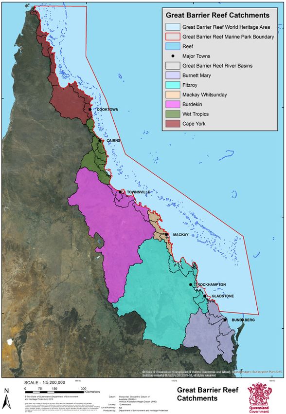
Vision
    Wetland extent, values and ecological processes are enhanced and contribute to the health and resilience of
    the Great Barrier Reef ecosystem.

    Purpose
    The purpose of this Strategy is to provide a range of objectives and activities to improve wetlands management
    that aligns with Australian and Queensland government initiatives, including targets in the Reef 2050 Long
    Term Sustainability Plan.

Context
The Queensland Office of the Great Barrier Reef has been established to coordinate and implement reef management strategies and
programs in conjunction with the Australian Government. As part of this role the office supported the Great Barrier Reef Water Science
Taskforce (the Taskforce) to provide scientific advice on the best approach to meeting water quality targets. The final report by the Taskforce
includes several recommendations that relate to wetlands, including extending regulations to protect natural wetlands and riparian areas.
The report also recommends an increased focus on innovation, including the use of treatment systems to remediate sediment and nutrient
runoff. Wetland and riparian restoration, and stream bank management were identified as important elements in protecting water quality.
The Taskforce suggests that incentives, such as stewardship payments, be used to deliver ecosystem restoration and repair of wetlands.
Further, the Taskforce proposes that a water quality offset framework be established for new or expanded development.
The Reef 2050 Long Term Reef Sustainability Plan (Reef 2050) is linked to the protection and improvement of the Outstanding Universal
Value of the Great Barrier Reef World Heritage Area. Reef 2050 recognises that ecologically significant areas such as wetlands are critical to
maintaining these Outstanding Universal Values and contributing to reef health, connectivity and resilience. Natural wetlands are specifically
addressed under the water quality and ecosystem health themes in the plan. An example of the relationship between wetlands and the
Outstanding Universal Value of the Reef is the important breeding habitats for the lifecycle movements of reef fish that freshwater and
estuarine wetlands provide.
Reef 2050 states that there has been a significant decline in many inshore habitats and species, especially in the southern part of the region.
It also highlights that there has been a decline in ecosystem processes that are important for maintaining water quality. The Reef 2050
includes a target for no net loss, and a net improvement in the condition of natural wetlands and riparian vegetation. Achieving this target
will contribute to reef resilience and ecosystem health.
This strategy identifies the key initiatives to help meet the Reef 2050 targets, including wetland and catchment management activities, better
access to information, enhanced planning and regulation, and productive collaborations with partners, such as regional natural resource
management groups and other non-government organisations.
The Reef Water Quality Protection Plan 2013 (Reef Plan) is a joint commitment of the Australian and Queensland governments to improve the
quality of water entering the Great Barrier Reef by addressing diffuse source pollution from agriculture—which is the main source of excess
nutrients, fine sediments and pesticides.
This strategy aligns with the land and catchment management targets under the Reef Plan. These include no net loss of natural wetlands,
an increase in the extent of riparian vegetation, and improvements in the ecological processes and values of wetlands. The Reef Plan also
proposes monitoring of wetland values and ecological processes. To that end, this strategy promotes a consistent wetlands assessment
methodology for reporting on these targets.
Queensland’s wetlands management is guided by Australia’s obligations under the Convention on Wetlands of International Importance
especially as Waterfowl Habitat 1971 (the Ramsar Convention), which has three key concepts: the wise use of all wetlands; designation of
internationally important sites; and international cooperation. The 4th Strategic Plan 2016-2024 of the Ramsar Convention states that to
achieve its objectives it is essential that ecosystem functions and services are recognised, maintained, restored and wisely used. There are two
Ramsar - listed wetlands within the Great Barrier Reef catchments—Bowling Green Bay, and Shoalwater and Corio Bays Area. The Great Sandy
Strait Ramsar - listed wetland site is located just outside of the area covered by the Reef 2050; however a significant part of the catchment that
affects this wetland is covered in the plan and is recognised as hydrologically connected to the Great Barrier Reef.

6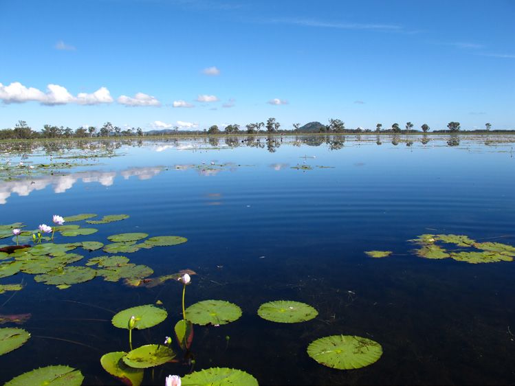
Bowling Green Bay Ramsar site

                                7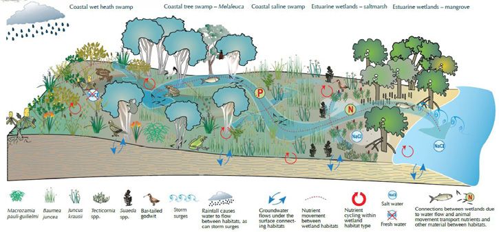
Wetland values and services
Wetlands provide many of the services that underpin the Outstanding Universal Value of the Great Barrier Reef. Wetlands provide important
habitat and valuable refuge for fish, birds and other wildlife. Wetlands can play an important role in improving water quality by trapping and
transforming pollutants such as nutrients, sediments and pesticides. Some wetlands help capture the first flush of pollutants after heavy rain.
Wetlands can also slow the flow of water, reducing soil erosion and the sediment load flowing out to the Reef. Both natural and constructed
wetlands assist in water quality improvement. However, excessive loading of wetlands with pollutants can result in loss of values.
Many wetlands have cultural values for Indigenous people, are important sources of water and have tourism and recreational values. Wetlands
can provide a buffer to extreme weather events such as storms, cyclones and extreme high tides. Rising seas, carbon dioxide levels, and other
climate change impacts can also be buffered by wetlands. The impacts of flooding can be reduced by wetlands.
Artificial wetlands and modified natural systems (for example dams, weirs and stormwater treatment wetlands) can provide substantial economic,
social, cultural and ecological benefits for the community. With careful planning and management, many wetland functions can be successfully
created and maintained in these systems.
Not all wetlands provide the same values or services. For example, a wetland may be primarily valued for its natural features, while another
wetland might be considered more important for their productivity or tourism values. A range of factors influence what values and services
a wetland provides including its location, size, type and condition. Most wetlands have multiple values and managing wetlands effectively
involves balancing these values to achieve the best outcomes economically, socially and environmentally.

Wetland pressures
Pressures on wetlands can vary depending on a number of factors including type of wetland, intensity or frequency of the pressure, landscape
setting and the management in place to mitigate the impacts. Further, pressures affecting a wetland may be located a long way from the wetland
itself. For example, a dam at the top of a catchment may significantly alter the hydrology of a downstream wetland.
Threats to wetlands include weeds and invasive animals; land development including land clearing and irrigated agriculture leading to changes in
salinity; drainage and water extraction; excessive land-based runoff of nutrients, pesticides and sediments leading to adverse impacts on habitats
and ecosystem functions; altered fire regimes; climate change. Changing climate is a significant long-term threat to wetlands—potentially altering
wetting and drying cycles, increasing fire frequency and intensity; and causing rising sea levels that lead to loss of freshwater wetlands.
It is important that wetlands are managed from a whole-of-catchment perspective to help ensure pressures are addressed at appropriate scales.

8
Managing wetlands
The Queensland Government has committed to improving the management of wetlands and coastal ecosystems in the Great Barrier Reef
catchments. This strategy provides an approach to managing wetlands and catchments that draws on the strengths and previous investments
of the Queensland Wetlands Program. Increased uptake of best management practice for wetlands and integration with existing management
activities can help improve water quality in Great Barrier Reef catchments. To achieve the best outcomes, planning processes and policies will
be reviewed to incorporate innovative approaches, new technologies and wetland management research.

  Case study—Queensland Wetlands Program
  The Queensland Wetlands Program was established by the Australian and Queensland governments in 2003 to support programs
  and projects that will result in long-term benefits for the sustainable use, management, conservation and protection of Queensland
  wetlands. The program, which is now run by the Queensland Government, is made up of multiple federal, state, local government and
  non-government partners and has helped raise awareness of wetlands and fostered an understanding of their importance. Increasing
  awareness encourages appreciation of the many values of wetlands.
  The tools developed by the program help wetland landholders, managers and decision makers. Tools relevant to the Great Barrier Reef
  catchments include

  Wetland management tools such as:
  • wetland mapping and classification
  • wetland conceptual models
  • conservation assessments
  • species lists and information
  • links to assessment and monitoring programs
  • rehabilitation and grazing guidelines
  • fact sheets and case studies
  • wetland projects search tool that lists on-ground wetland projects from a range of funding programs, stakeholder groups and land managers.

  Education and communication tools:
  • a range of videos
  • school curriculum, brochures and posters.
  A fact sheet of the program tools is available on the WetlandInfo web portal: http://wetlandinfo.ehp.qld.gov.au

A number of additional measures will enhance wetlands management, such as improved access and delivery of high quality information
and education about on-ground wetland management projects. Improved access to information can build community understanding and
promotes best practice management of wetlands. The Department of Environment and Heritage Protection hosts the WetlandInfo web portal
(www.wetlandinfo.ehp.qld.gov.au), which is a key resource for providing information to the public on all aspects of wetlands management.
Partnering and collaboration are crucial to effective wetlands management. Wetlands occur on private and public lands, and the
responsibility for managing wetlands is shared between all levels of government, land managers, Traditional Owners, industry, natural
resource management and other organisations, as well as the wider community. The science community also has a key role to play
in informing wetlands management. Citizen science initiatives provide information on wetland values that can assist with wetland
management. A key component of this strategy is to effectively engage, consult and collaborate with stakeholders to identify and prioritise
what management activities should occur for wetlands and where.
The Great Barrier Reef Marine Park Authority has been a long term partner in promoting the importance of coastal ecosystems to the health
of the Reef. Equally, the Queensland Department of National Parks, Sport and Racing are important managers of coastal areas including
national parks, the Great Barrier Reef Coast Marine Park and Fish Habitat Areas.

                                                                                                                                                 9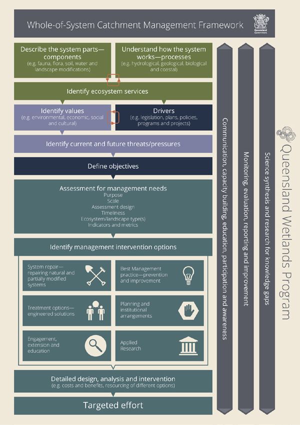
Whole-of-system catchment management framework
The whole-of-system catchment management framework is an initiative of the Queensland Wetlands Program. It provides an integrated
approach to catchment management and the protection, maintenance and restoration of wetland systems. The framework proposes that
information on natural and human components of a system can be integrated with an understanding of how catchments function. Threats
can then be used to prioritise options for management intervention, based on the objectives associated with a management activity.
The framework provides the foundation for establishing a comprehensive approach to prioritising investment.
Understanding the parts of a catchment, how it works and the values and services it provides are critical to determining appropriate and
integrated management activities. A whole-of-system approach encompasses consideration of both terrestrial and aquatic environments
within broader catchment environmental processes.
It is intended that the framework will be used in day-to-day wetlands management decisions that will help deliver more effective and
sustainable management of the catchment. Figure 2 illustrates the key steps of the framework.

 Lake Mary, Yeppoon

10
Figure 2   Whole-of-system catchment management framework

                                                            11
Case study—Walking the landscape to improve understanding The Queensland Wetlands Program has established the walking the landscape process that encourages consideration of wetlands from a whole-of-landscape perspective to develop and demonstrate an understanding of how a catchment functions e.g. in terms of how water flows and how that flow is affected by geology, topography, vegetation and land use. It recognises that ecological processes and the long-term resilience of a landscape are interconnected and that management decisions can impact across land and water. The process integrates existing data with expert knowledge to develop a whole-of-system map linked to conceptual models showing how the catchment functions. A conceptual model of coastal wetland connections. An outline of the Walking the landscape process is available on the WetlandInfo web portal: http://wetlandinfo.ehp.qld.gov.au 12
Themes
Five themes are presented to protect wetlands and improve their management. Each theme has a corresponding table consisting of the goal,
objectives and activities.

Theme 1: Improving wetlands information for decision making and action
Goal:		              Information is available for evidence-based decision making and action
Scientifically-robust information on wetlands is needed to effectively understand and manage all aspects of wetlands. Much of this information
is consolidated into a knowledge base delivered through the WetlandInfo web portal. There is an ongoing need to improve understanding of
the values and services of wetlands in Great Barrier Reef catchments to better inform decisions and actions into the future and address key
knowledge gaps.
Knowing where wetlands are, the different types of wetlands, how they function and how they support different values is crucial to maintaining the
health of the Great Barrier Reef. It is also important to integrate and consolidate information from research into management decision making.

Table 1. Improving wetlands information for decision making and action
                                                                              Goal:
                                            Information is available for evidence-based decision making and action
                                  Objectives                                                           Current and proposed activities
 1.1      Information on the location, type and extent of wetlands (including   Continue to map and report on changes in extent of wetlands.
          groundwater requirements) is available and changes are monitored      Extend Groundwater Dependent Ecosystem mapping to all Great Barrier
          and reported.                                                         Reef catchments.
                                                                                Improve the scale and key attributes of wetland mapping.
 1.2      Improvements to ecological processes and environmental values of      Monitor and report on ecological processes and environmental values
          wetlands are known.                                                   of wetlands.
 1.3      Wetlands and other coastal ecosystems are managed from a              Undertake the Whole-of-catchment management framework and Walking the
          whole-of-catchment perspective.                                       Landscape processes.
                                                                                Update aquatic conservation assessments for all Great Barrier Reef catchments.
                                                                                Redevelop and encourage use of a decision support tool to improve
                                                                                management decisions and prioritisation.
 1.4      Wetlands are managed to best practice standards.                      Promote best practice wetlands management tools and guidelines.
 1.5      Deliver value for money investments, encourage collaboration and      Maintain a system to report historic and new on-ground works for wetlands
          avoid duplication in wetlands-related projects.                       management.
 1.6      Information on wetlands is publicly accessible to inform decision     Continue to deliver information through the WetlandInfo web portal.
          making and action.
 1.7      Wetlands used by shorebirds and other waterbirds are managed          Update information on migratory and other waterbirds to help inform
          with best available data and information.                             decision making and management action.
                                                                                Continue to collaborate on the conservation of shorebirds and other waterbirds.
 1.8      Applied research addresses wetland knowledge gaps and assists         Consolidate scientific data and information into easy to use formats.
          management.                                                           Form partnerships to address research needs including knowledge gaps.
                                                                                Investigate how pollutants move through groundwater and impact wetlands.
 1.9      The role of natural and artificial wetlands in water quality          Encourage research into the role of natural and artificial wetlands in water
          improvement are understood and incorporated into relevant Reef        quality improvement.
          initiatives.                                                          Incorporate best information on wetlands into Reef initiatives.
 1.10     Barriers to fish passage are managed to improve ecosystem health.     Consolidate mapping of barriers to fish passage and guidance on best
                                                                                management.
 1.11     The extent and type of intertidal and subtidal habitats are known.    Conduct and make available mapping of intertidal and subtidal habitats of
                                                                                high risk ecosystems.
 1.12     The ecological character of Ramsar wetlands is maintained, and        Promote research and monitoring to assist to identify the ecological
          changes detected.                                                     character of Ramsar wetlands and detect change.
 1.13     Tools are available to mitigate the impacts of climate change on      Updated tools to integrate wetlands and climate change in the context of
          wetlands.                                                             resource planning, management and ecosystem repair to enable effective
                                                                                site based wetland decisions.

                                                                                                                                                               13
Case study—expanding the knowledge base of wetland extent
You cannot manage effectively what you cannot measure. Being able to identify where wetlands occur, their type and the area they
cover is essential. Wetland mapping in Queensland helps planners, managers and landholders make well informed decisions about the
protection and management of wetlands. The Queensland Wetlands Program has produced a consistent map of the state’s swamps,
lakes, rivers, estuarine and marine wetlands. Regular updates to the mapping managed by the Queensland Herbarium helps identify
changes in wetland extent over time. A key initiative has been the expansion of the mapping and classification methods to Groundwater
Dependent Ecosystems.
710,000 720,000 730,000 740,000 750,000 760,000
149°E
149°10'E
149°20'E
149°30'E
21°S
t Creek 21°S
Constan
Mar
tin
k
Cre
Cr ee
BUCASIA
ek
!
Leila
EIMEO
!
DOLPHIN HEADS
!
Reliance Creek
7,670,000
7,670,000
SLADE POINT
!
Balnagowan Creek
FARLEIGH
!
GLENELLA
!
Pioneer River Bassett Basin
k
Cree MACKAY
den
Furs !
Pioneer River
7,660,000
7,660,000
WALKERSTON
!
NEBO ROA
21°10'S D
Flat Top Island
Bake
rs Cree 21°10'S
k
Round Top Island
BAKERS CREEK
ek
Cre
!
an
nn
cle
Ma
7,650,000
7,650,000
Cre ek
Ross
Tw
MCEWENS BEACH
o
Mile
!
Cre
ETON
ek
!
Sandy Creek
Sandy Creek
ek
k HECTOR
ree
Cre
C !
ny
y
Sto
nd
Sa
k
Oaky Cree
Cr eek HALF TIDE
ek
Rock
k
!
ree
Cre
k
C
ree
ns
Louisa
rC
ek
ma
Cre
hu
nch
Art
Alligator Creek
ck
Fre
Ro
7,640,000
7,640,000
21°20'S
ek 21°20'S
re
LC
B
ek
Bell Cre
Ca
bb
ag
eT
ree GRASSTREE
Cre ! ZELMA
ek !
CAMPWIN BEACH
!
SA
ek
RIN
Cre SARINA BEACH
ers
A
litt
HO
!
ek Sp
M
Cre
EB
t
ec
US
sp
Pro
H
RO
AD
7,630,000
7,630,000
Alli SARINA
ga
tor !
Cre
ek
AD
reek
RO
A
C
RIN
pect
ek
Tara Creek SA
Cre
H
Pros
G
OU
ning
O R
LB
Run
R
MA ARMSTRONG BEACH
Prospect Creek
!
ek
Cre
illy
W
OAD
k
H SA ne Cree
AR
RIN
Pla
k
ree
yC
mm
UG
To
RO
LBO
21°30'S
R
MA
149°10'E
149°20'E
149°30'E
21°30'S
7,620,000
7,620,000
149°E
710,000 720,000 730,000 740,000 750,000 760,000
Further information on wetland mapping (including methodology and digital data) is available from www.wetlandinfo.ehp.qld.gov.au
Water bodies and wetland regional ecosystems Queensland Wetlands 2013
Accuracy information: The positional accuracy of wetland data mapped at a scale of 1:100,000 is +/-100m with a minimum polygon size
of 5ha or 75m wide for linear features, except for areas along the east coa st which are mapped at the 1:50,000 scale with a positional
accuracy of +/-50m, with a minimum polygon size of 1ha or 35m wide for linear features. Wetlands smaller than 1ha are not delineated on
Wetland the wetland data. Consideration of the effects of mapped scale is necessary when interpret ing data at a larger scale, e.g. 1:25,000. For
Water
bodies
regional
ecosystem
MAP SERIES VERSION 4.0 property assessment, digital linework should be used as a guide only. The extent of wetlands depicted on th is map is based on rectified
2013 Landsat ETM+ imagery supplied by Statewide Landcover and Trees Study (SLATS), Department of Science, Information Technology
and Innovation (DSITI). The extent of water bodies is based on the maximum extent of inundation derived from available Landsat ima gery
Marine system (e.g. open ocean) Open ocean extending to the Queensland 3nm coastal limit. Includes shallow up to and including the 2013 imagery.
coastal indentations or bays without appreciable freshwater inflows, and coasts that are exposed to oceanic
waves and currents. Water regimes are determined primarily by oceanic tides. MACKAY Data sources: Water body mapping derived from satellite imagery, DSITI; regional ecosystem mapping, DSITI; drainage mapping,
Geoscience Australia (GA), Department of Defence and DSITI; Roads, MapInfo Australia Pty Ltd, 2006; Towns and Built-up areas, GA,
8755
Estuarine system (e.g. mangroves, salt flats and estuaries) Includes wetlands with oceanic water that are 2003; Coastline, GA, 2004; Queensland 3NM Limit , Australian Maritime Boundaries Information System (A MBIS), GA, 2001; Digital
significantly diluted with freshwater derived from land drainage. Cadastral Database (DCDB), Department of Natural Resources and Mines, July 2015; Queensland springs database, Queensland
Herbarium, 2015; SRTM 90m DEM, USGS/NASA, 2006. Landsat ETM+ imagery supplied by the Australian Centre for Remote Sensing
¯
Riverine system (e.g. river and creek channels) Wetlands and deepwater habitats contained within a channel. (ACRES), Australian Surveying and Land Information Group (AUSLIG), Canberra. The satellite imagery used in this product has b een pre-
Due to scale constraints these areas may include fringing palustrine vegetation. processed by SLATS, DSITI.
Lacustrine system (e.g. lakes) Wetlands and deepwater habitats situated in a topographic depression or a
Disclaimer: While every care is taken to ensure the accuracy of this product, the Queensland and Australian governments and MapInfo
dammed river channel. Includes areas where emergent perennial vegetation has less than 30% areal coverage Australia Pty Ltd make no representations or warranties about its accuracy, reliability, completeness or suitability for any particular purpose
and total waterbody area exceeds 8ha. and disclaim all responsibility and all liability (including without limitation, liability in negligence) for all expenses, losses, damages (including
Horizontal Datum: GDA 1994 indirect or consequential damage) and costs which might be incurred as a consequence of reliance on the product, or as a resu lt of the
Palustrine system (e.g. vegetated swamps) Wetlands dominated by persistent emergent vegetation or where
product being inaccurate or incomplete in any way and for any reason.
water in deepest part of the basin is less than 2m, active wave formed shores or bedrock features are lacking.
Projection: Map Grid of Australia 1994 (MGA94 Zone 55)
Date of map production: July 2015 © The State of Queensland 2015
# Wetland point features (e.g. springs, rockholes) 0 2 4 6 8 10
Riverine system (drainage lines) Kilometres
MAP LOCATION IN QUEENSLAND
Areas that may include wetlands Scale 1:100,000 at A1 size
Remnant regional ecosystem 5180% wetland (mosaic units) ADJOINING MAPS
Remnant regional ecosystem 150% wetland (mosaic units) Weipa !
CUMBERLAND CORAL
CALEN SCAWFELL
ISLANDS
The above descriptions are an abbreviated version of the full descriptions in the Wetland Mapping and
Classification Methodology www.wetlandinfo.ehp.qld.gov.au 8656 8856
8756 SEA
Wetlands ! Cairns
For the purposes of mapping and classification, wetlands are:
areas of permanent or periodic/intermittent inundation, with water that is static or flowing , fresh, brackish or salt, including areas of marine Georgetown !
water the depth of which at low tide doe s not exceed 6 m. To be a wetland the area must have one or more of the following attributes: ! Townsville
i. at least periodically the land supports plants or animals that are adapted to and dependent on living in wet conditions for a t least part PRUDHOE
MIRANI MACKAY
of their life cycle, or ISLAND
! Mount Isa
ii. the substratum is predominantly undrained soils that are saturated, flooded or ponded long enough to develop anaerobic condit ions in Mackay
8655 8755 !
the upper layers, or 8855
iii. the substratum is not soil and is saturat ed with water, or covered by water at some time.
Longreach ! Rockhampton !
Other Feature Bundaberg !
CURLEW
NEBO CARMILA
! Towns Built-up areas of Queensland ISLAND
Roma !
8654 8754 Brisbane !
Roads Ocean outside 3nm limit 8854
Cadastral boundaries (>0.5km² area) Land at least 1km outside of Queensland
14Theme 2: Wetland planning arrangements
Goal: Funding, non-statutory and statutory planning arrangements in place to protect, manage
and enhance wetlands
Understanding the role of wetlands in the catchment and the multiple values they support will assist in planning for the protection, management
and rehabilitation of wetlands. Providing strategic direction for funding programs on where to focus investment for the most effective outcome is
essential. Regulation of activities impacting wetlands should be based on accurate and robust mapping, data and other information.
Updating and maintaining statutory and non-statutory planning and management information for Ramsar-listed sites is a key initiative in
improving the management of these internationally recognised wetlands.
Table 2. Wetland planning arrangements
Goal:
Funding, non-statutory and statutory planning arrangements in place to protect, manage and enhance wetlands
Objectives Current and proposed activities
2.1 Water allocations consider and maintain wetland values Continue to identify wetland values in catchment-based water
and services. allocation and management planning processes.
2.2 Natural and near natural wetlands and riparian areas are Extend legislation to protect natural and near natural wetlands and
consistently protected under legislation. riparian areas in all Reef regions.
2.3 Wetlands and whole-of-catchment management are Continue to include wetlands management in Natural Resource
incorporated into strategic planning and funding initiatives. Management Plans and Water Quality Improvement Plans.
Encourage other relevant plans and policies to include wetland
management objectives.
2.4 Up-to-date information is available for listed Ramsar Update and publish Ramsar Information Sheets for all listed sites.
wetland sites.
2.5 Wetlands are protected through formal planning mechanisms. Review the State Planning Policy, coastal planning and local
government planning schemes to assess planning controls for
Great Barrier Reef wetlands and amend as required.
2.6 Wetlands are recognised in protected area planning and Continue to include wetlands management principles in protected
management. area planning.
2.7 Incorporate wetlands into nature refuges and other voluntary Continue to consider wetlands in nature refuges and other
conservation measures. voluntary conservation arrangements.
2.8 Offset provisions are used to strengthen wetlands management. Strengthen offset provisions for wetlands by expanding provisions
to additional catchments.
Consider options that include direct benefit management plans to
guide offset investments.
2.9 Maintain and enhance connections to improve reef Include connections to improve reef ecosystem health and
ecosystem health and resilience. resilience in planning, legislative and policy initiatives.
15Case study—prioritising conservation values High conservation value wetlands are identified using the Department of Environment and Heritage Protection’s Aquatic Conservation Assessments (ACAs) and these areas are included as Matters of State Environmental Significance under Queensland’s state planning provisions. Aquatic Conservation Assessments are based on sound science and provide a comprehensive and transparent method for assessing the conservation values of wetlands. They can provide a source of baseline wetland conservation and ecological information to support regional planning, in assessing development applications for natural resource management and protected area management planning. An ACA can have an application in determining priorities for protection, regulation or rehabilitation of wetlands, as well as on-ground investment decisions. 16
Theme 3: On-ground activities to protect, manage and rehabilitate wetlands
Goal: 		           Implementation of on-ground activities that improve the health of wetlands and enhance
		                 their contribution to Reef resilience through statutory and non-statutory mechanisms
Reducing risk to wetlands through the implementation of regulatory provisions and compliance, as well as adoption of best practice in
wetlands management are critical components of this theme. Implementing on-ground management would be enhanced through new
initiatives, such as consistent prioritising of wetland investment; greater funding for on-ground activities, including restoration of wetlands;
and identifying incentives for wetland management on private land.

Table 3. On-ground activities to protect, manage and rehabilitate wetlands
                                                                 Goal:
       Implementation of on-ground activities that improve the health of wetlands and enhance their contribution to Reef resilience
                                            through statutory and non-statutory mechanisms
                               Objectives                                                    Current and proposed activities
 3.1     Wetlands compliance activities are enhanced.                     Continue and enhance compliance activities that contribute to the
                                                                          protection and management of wetlands, including riparian areas.
 3.2     Wetland values are enhanced through targeted, coordinated Continue to collaborate with key stakeholders, including NRM
         and effective rehabilitation/restoration initiatives.     groups to prioritise on-ground works.
                                                                          Encourage use of existing decision support tools and the Whole-
                                                                          of-system catchment management framework to target effort for
                                                                          wetland rehabilitation/restoration.
 3.3     Land managers understand the connection between their            Continue to develop education and communication initiatives for
         actions and the health of wetlands, catchments and the           land managers on the importance of wetlands.
         Great Barrier Reef.
 3.4     Wetlands are connected for improved environmental                Develop, fund and implement measures to enhance connections,
         outcomes and address barriers to fish passage.                   including removal of barriers via restoration/rehabilitation for projects
                                                                          to improve wetland and broader reef ecosystem health and resilience.
 3.5     Innovative approaches to wetland and coastal ecosystem           Long term funding of wetland and coastal ecosystem repair is
         repair are in place.                                             achieved through application of innovative options, such as trialling
                                                                          innovative restoration techniques.
                                                                          Explore incentives, such as stewardship payments, to achieve
                                                                          ecosystem restoration and rehabilitation of wetlands.
 3.6     Wetland values and services are enhanced through                 Develop, fund and implement management programs that address
         management of threats.                                           threats such as climate change, invasive species and land-based
                                                                          runoff. Actions are monitored and reported to inform future on-
                                                                          ground works.
 3.7     Natural wetlands that significantly contribute to improved       Explore an acquisition fund to identify areas that significantly
         Reef water quality and/or wetland conservation are               contribute to improved Reef water quality or conserve high priority
         protected through acquisition.                                   wetlands and explore an acquisition fund, including consideration
                                                                          of management of these wetlands.
 3.8     On-ground managers are skilled in best available wetland         Undertake on-ground management training to build capacity and
         management techniques.                                           meet specific needs.
 3.9     Wetlands in protected areas and/or Ramsar sites maintain         Implement wetland management planning that is in accordance
         their ecological character.                                      with legislation and international conventions, agreements and
                                                                          partnerships.

                                                                                                                                                  17
Case study—managing wetlands
Understanding how a wetland functions and what is needed to protect values is important when effectively managing a wetland. The
Queensland Wetlands Program has produced a comprehensive range of tools and guides to assist on-ground management of wetlands.
This includes grazing, intensive agriculture and rehabilitation guidelines, templates for management plans, case studies, as well as
models of how wetlands function.
Wetlands Field Workshop
18Theme 4: Education, communication and capacity building
Goal: Improved stakeholder awareness of the value of wetlands and the management tools available
Education, communication and capacity building are key components of a program to encourage protection and best practice management
of wetlands. The communication and education activities proposed will facilitate this by continuing to provide information on wetlands.
There are many avenues for engagement including face-to-face meetings, distribution of information via brochures, newsletters, fact sheets,
interactive websites and social media. Diverse approaches will be adopted, actively encouraging dialogue with stakeholders regarding
wetlands management and incorporating research findings into messages.
Table 4. Education, communication and capacity building
Goal:
Improved stakeholder awareness of the value of wetlands and the management tools available
Objectives Current and proposed activities
4.1 Wetland visitors, residents and industry appreciate Continue to prepare and promote educational material and activity
wetlands and actions they can take to conserve wetlands. programs for managers, schools, tertiary institutions, industry,
community groups, and other relevant sectors.
Publish a book promoting wonderful wetlands of Queensland.
4.2 Wetlands information is available online. Continue to provide wetland information through the WetlandInfo
web portal.
Wetlands management information is available on other relevant
websites including federal and local government, NRM groups, other
non-government organisations and industry.
4.3 Wetlands education is available at strategically located sites. Provide wetlands interpretation material and education centres with
the best available information.
4.4 Innovative approaches are used to deliver key messages on Explore new message delivery mechanisms that assist wetland
wetlands. conservation including social media to broaden audience coverage.
4.5 Collaborative partnerships promote wetlands best practice Continue the Great Barrier Reef Wetlands Network to build
management. connections between wetland decision makers and managers.
Continue regional and local wetlands networks to implement
wetlands management activities.
Establish stakeholder advisory groups for Ramsar listed sites to
collaborate on management activities.
4.6 Traditional Owners’ cultural and spiritual values and Engage with Traditional Owners to share information on indigenous
traditional uses of wetlands are incorporated into wetlands use and values of wetlands.
initiatives. Consult with Traditional Owners on wetland-related initiatives.
4.7 Tourism and recreational use of wetlands is encouraged. Explore opportunities for promoting public access to wetlands,
including online information on wetlands to visit.
Ensure access to and use of wetlands does not impact on
wetland values.
4.8 Communities are aware of wetlands and their values Promote citizen science initiatives that contribute to the protection,
through robust citizen science. maintenance and enhancement of wetland values.
Create a sense of community responsibility and ownership.
4.9 Build capacity amongst people delivering wetland Establish networks, training and education initiatives to improve
management and information services. the capacity of policy makers, environmental managers and others
delivering information, wetland tools and extension activities.
4.10 Explore new partnerships to enhance collaborations that Expand the Queensland Wetlands Program Governance Group
result in improved wetlands management. to include other key partners not represented.
Establish a high level multi-disciplinary technical reference
group to provide direction and technical support for wetland
management initiatives.
19Case study—WetlandInfo promoting awareness, understanding and appreciation
The WetlandInfo website (www.wetlandinfo.ehp.qld.gov.au) is the premier website for wetland resources in Queensland. It links wetland
planners, managers and landholders to the widest range of wetland management resources in Australia. It contains a range of material
including wetland definitions, maps of wetlands, a central data collection point for scientific purposes, planning guidelines, and case studies.
Regularly updated, the website provides topical information on the wetlands of the Great Barrier Reef catchments. The website hosts
a range of resources to assist with education including school curriculums, fact sheets, brochures, videos, posters and interactive
learning. More than 500 people a day access the website.
Our wetlands are …
...protecting us
from floods
What makes our wetlands special?
...supporting our
primary industries
...where we can
relax and have fun
...keeping our
waterways healthy
...rich habitats for
wildlife
#29506 QWP: 2010/15 (updated 2013 #30318 )
Find all your wetlands information
on WetlandInfo
www.wetlandinfo.ehp.qld.gov.au
20Theme 5: Monitoring, evaluation, reporting and improvement
Goal: An adaptive management approach incorporating effective monitoring, evaluation,
reporting and improvement is implemented to improve wetland management
This theme will assist with monitoring the targets of the Reef Water Quality Protection Plan 2013 and the Reef 2050 Long-Term Sustainability Plan.
A longer term evaluation of progress is essential to monitor change for those trends that take time to detect, as well as identifying emerging
issues. Critical to this process is the identification of benchmarks from which to measure impacts and suitable indicators to track change.
Table 5. Monitoring, evaluation, reporting and improvement
Goal:
An adaptive management approach incorporating effective monitoring, evaluation, reporting and improvement
is implemented to improve wetland management
Objectives Current and proposed activities
5.1 Monitoring the effectiveness of management initiatives on Continue to monitor baseline data and indicators of wetlands to
wetlands. measure change resulting from management interventions.
5.2 Monitoring, reporting and evaluation of wetland targets. Continue to monitor and report on wetland targets in the Reef 2050
Long Term Sustainability Plan.
Report through Reef Water Quality Protection Plan report cards and
State of the Environment Queensland.
Investigate opportunities for more efficient and cost effective
monitoring methods to report on the conditions of wetlands.
5.3 Obligations for reporting through international agreements, Continue to deliver state jurisdictional reporting as required under
conventions and partnerships are fulfilled. the Ramsar Convention and bilateral migratory bird agreements.
5.4 Meet objectives and milestones of wetlands projects. Record and report on milestones and targets for wetlands projects.
5.5 Assess the effectiveness of the Wetlands in the Great Undertake five yearly reviews of the Wetlands in the Great Barrier
Barrier Reef Catchments Management Strategy. Reef Catchments Management Strategy, including consideration of
relevant research findings and contemporary issues.
21Case study—monitoring the extent of wetlands Knowing the extent of wetlands and how this changes over time helps wetland managers target efforts to those areas most in need. Mapping of Queensland’s wetlands is updated every four years and provides important information on changes in the extent of wetland types. This mapping is delivered across a range of scales including natural resource management regions, drainage basin and local government areas. The findings are reported through WetlandInfo, Reef report cards, and the Queensland State of the Environment report and regional report cards. Great Barrier Reef contributing catchments wetland area by system 2013 System Area (km²) % wetlands area % total area Artificial and highly modified 1,673 10.9% 0.4% Estuarine 4,010 26.1% 0.9% Lacustrine 224 1.5% 0.1% Palustrine 2,811 18.3% 0.7% Riverine 6,665 43.3% 1.6% Total 15,383 100.0% 3.7% Source: http://wetlandinfo.ehp.qld.gov.au/ Werribee Creek State Forest, Rockhampton 22
Governance                                                              Next steps
This strategy is a whole-of-government managed program within           The implementation of this strategy will be achieved through
the Department of Environment and Heritage Protection. It has been      the activities articulated under the five themes. Implementation
produced by the Queensland Wetlands Program, which is formally          planning will be undertaken in collaboration with stakeholders that
overseen by a governance group. The group is composed of members        will set specific, measurable, achievable, relevant and time-bound
from key stakeholder groups (see below). The objective of the           targets to deliver the actions for the period 2016-2021. Included in
governance group is to review the administration of projects under      the implementation planning will be the allocation of actions to the
the Program, as well as support monitoring and reporting on the         relevant stakeholders and identification of resourcing.
strategy. The group will also support the strategy by communication
                                                                        Delivery of the actions in the strategy and achieving positive
and engagement across sectors to raise awareness of the strategy
                                                                        outcomes requires ownership, cooperation and coordinated action
and the efforts undertaken to improve wetland values in Great Barrier
                                                                        by stakeholders. Improved wetland and catchment management for
Reef catchments, with potential to expand to provide support to the
                                                                        reef health cannot be achieved by one organisation.
implementation of the strategy.
                                                                        Protection and management of wetlands in Great Barrier Reef
The governance group is presently composed of ten members from:
                                                                        catchments is complex, involving numerous and diverse
• Queensland Regional Natural Resource Management Groups Collective     stakeholders. It requires a multi-disciplinary approach, with a strong
• Local Government Association of Queensland                            focus on education, communication, working with communities and
• Department of Environment and Heritage Protection                     an ongoing commitment to improving the health of wetlands, their
                                                                        catchments and the Reef.
• Great Barrier Reef Marine Park Authority
• Department of Natural Resources and Mines
• Department of National Parks, Sports and Racing
• Department of Agriculture and Fisheries
• Department of Science, Information Technology and Innovation.

Note: A glossary of terms used in this strategy is available at www.wetlandinfo.ehp.qld.gov.au

                                                                                                                                           23
24
You can also read


