Controlled flight into terrain involving Mooney M20J, VH- DJU - ATSB Transport Safety Report
←
→
Page content transcription
If your browser does not render page correctly, please read the page content below
Controlled flight into terrain
involving Mooney M20J, VH-
DJU
26 km west of Coffs Harbour Airport, New South Wales, on 20 September 2019

 ATSB Transport Safety Report
 Aviation Occurrence Investigation (Defined)
 AO-2019-052
 Final – 19 January 2021
Cover photo:       Supplied

Released in accordance with section 25 of the Transport Safety Investigation Act 2003

Publishing information
Published by:            Australian Transport Safety Bureau
Postal address:          PO Box 967, Civic Square ACT 2608
Office:                  62 Northbourne Avenue Canberra, ACT 2601
Telephone:               1800 020 616, from overseas +61 2 6257 2463
                         Accident and incident notification: 1800 011 034 (24 hours)
Email:                   atsbinfo@atsb.gov.au
Website:                 www.atsb.gov.au

© Commonwealth of Australia 2021

Ownership of intellectual property rights in this publication
Unless otherwise noted, copyright (and any other intellectual property rights, if any) in this publication is owned by the
Commonwealth of Australia.

Creative Commons licence
With the exception of the Coat of Arms, ATSB logo, and photos and graphics in which a third party holds copyright,
this publication is licensed under a Creative Commons Attribution 3.0 Australia licence.

Creative Commons Attribution 3.0 Australia Licence is a standard form licence agreement that allows you to copy,
distribute, transmit and adapt this publication provided that you attribute the work.
The ATSB’s preference is that you attribute this publication (and any material sourced from it) using the following
wording: Source: Australian Transport Safety Bureau

Copyright in material obtained from other agencies, private individuals or organisations, belongs to those agencies,
individuals or organisations. Where you want to use their material you will need to contact them directly.

Addendum

    Page                Change                                                                          Date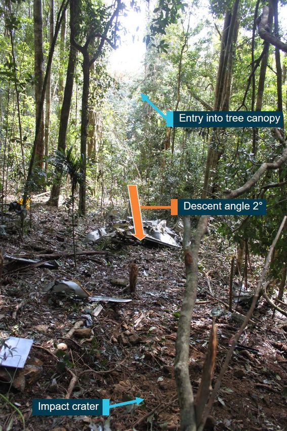
Safety summary
What happened
At about 0640 Eastern Standard Time on 20 September 2019, a Mooney M20J aircraft, registered
VH-DJU, departed Murwillumbah, New South Wales for a private flight under visual flight rules to
Taree, New South Wales. On board were the pilot and one passenger.
At 0717, when DJU was 45 NM north of Coffs Harbour, the pilot contacted air traffic control and
requested a clearance to transit the Class C controlled airspace at 6,500 ft. Air traffic control
advised that a clearance was not available at that altitude and that, due to cloud conditions, a
visual transit of the airspace would only be possible at an altitude not above 1,000 ft. The pilot
then advised that the flight would descend to ‘not above 1,000 ft’.
The aircraft continued on a direct track to Taree and at 0724 the pilot reported that the aircraft was
operating outside controlled airspace in clear conditions at 4,100 ft and would remain on that
track. The aircraft was then climbed to 4,500 ft and at 0732, commenced a descent in the vicinity
of high terrain.
The aircraft did not arrive at Taree as expected so a search was initiated. The aircraft was found
to have collided with terrain about 26 km west of Coffs Harbour Airport. The two persons on board
were fatally injured and the aircraft was destroyed.

What the ATSB found
The ATSB found that the pilot was not provided clearance to transit Class C airspace due to the
trainee controller’s conservative assessment that workload would not allow it although there was
no conflicting traffic, meteorological factor or limiting air traffic control instructions or procedures.
The trainee’s supervisor accepted the assessment as an alternate transit option was provided to
the pilot. Additionally, the information subsequently provided by air traffic control likely resulted in
the pilot deciding to descend the aircraft from 6,500 ft instead of other available safe options. This
descent exposed the flight to increased risk.
The ATSB also found that the pilot was not carrying suitable navigation equipment and had most
likely not obtained the required weather forecasts. These factors reduced the pilot's ability to
manage the flight path changes and identify the high terrain. This led to the aircraft being
descended toward the high terrain in visibility conditions below that required for visual flight,
resulting in controlled flight into terrain.
The pilot had also not completed the required flight reviews or proficiency checks. This resulted in
the pilot not possessing the required licence to undertake the flight and likely led to a deterioration
in the knowledge and skills required for effective flight management and decision-making.

What has been done as a result
Following the occurrence, Airservices Australia (Airservices) provided additional training for air
traffic controllers focussing on clearance issues, workload assessments, and coordination with
other traffic units where decisions affect the other unit. An information and education package was
developed for controllers regarding the provision of advice and information to pilots not subject to
a clearance.
Performance checks and unit reviews were also undertaken to provide assurance that airways
clearances were consistently issued in accordance with documented procedures. Airservices also
included additional content in on-the-job instructor professional development sessions to ensure
trainees’ capability is commensurate with actual workload to optimise performance.

                                                   ›i‹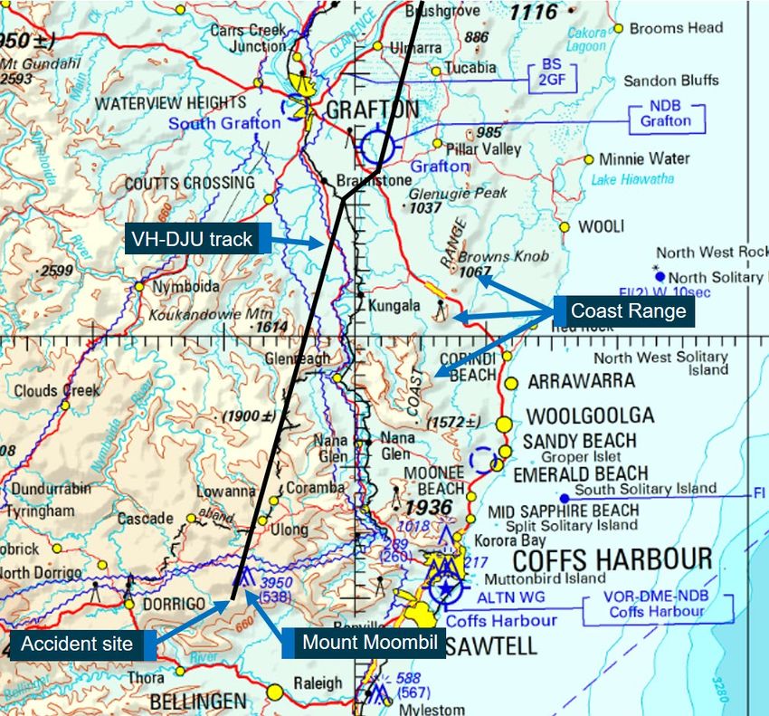
Safety message
The safety risks of visual pilots flying into non-visual conditions are well documented. This
continues to be a recurring factor in aircraft accidents and has been the focus of numerous
previous ATSB reports and publications.
This accident also emphasises the importance of pilot and flight preparation. Ensuring that all
required training is completed assists a pilot to both develop and maintain the necessary skills to
manage challenges that may be encountered during a flight, such as inclement weather or
inadvertent entry into non-visual conditions. Further, confirming that appropriate operational
information is obtained and readily available ensures that a pilot is well prepared to anticipate
in-flight complications and successfully manage unforeseen challenges.
The accident also illustrates the significant influence that air traffic control can have on the conduct
of a flight.

                                                  › ii ‹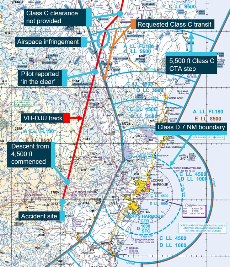
Contents
  Safety summary ........................................................................................................................i
  The occurrence ........................................................................................................................1
  Context ......................................................................................................................................3
    Pilot information and training                                                                                                              3
              Licencing and flight reviews under CASR Part 61                                                                                  3
              Fatigue                                                                                                                          4
       Medical and pathological information                                                                                                    4
       Aircraft information                                                                                                                    5
              Global Navigation Satellite System units                                                                                         6
       Terrain in the accident vicinity                                                                                                        6
       Meteorology                                                                                                                             7
              BoM information                                                                                                                 8
              Automatic terminal information service                                                                                          9
              Witness                                                                                                                        10
              Visual meteorological conditions                                                                                               10
       Airspace and airways clearances                                                                                                       10
              Coffs Harbour airspace                                                                                                         10
              Flight notification                                                                                                            12
              Traffic                                                                                                                        12
              Class C clearance request                                                                                                      12
              Class C airspace infringement                                                                                                  13
              Class D clearance request and communications                                                                                   13
              Fatigue                                                                                                                        14
              Future Coffs Harbour airspace reclassification                                                                                 14
       Recorded flight data                                                                                                                  14
       Accident site and wreckage                                                                                                            15
       Similar occurrences                                                                                                                   17
  Safety analysis ...................................................................................................................... 19
     Introduction                                                                                                                        19
     Class C clearance request                                                                                                           19
     Decision to descend                                                                                                                 20
     Pre-flight preparation                                                                                                              20
     Flight into unsuitable conditions                                                                                                   20
     Flight reviews                                                                                                                      21
     Mandatory medical disclosure                                                                                                        21
  Findings ................................................................................................................................. 22
     Contributing factors                                                                                                                    22
     Other factors that increased risk                                                                                                       22
  Safety action ......................................................................................................................... 23
  General details ...................................................................................................................... 24
  Sources and submissions .................................................................................................. 25
  Australian Transport Safety Bureau .................................................................................. 26

                                                                  › iii ‹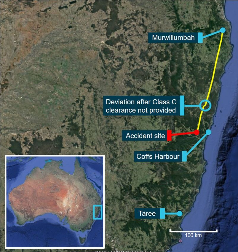
ATSB – AO-2019-052

The occurrence
At about 0640 Eastern Standard Time 1 on 20 September 2019, a Mooney M20J aircraft,
registered VH-DJU, departed Murwillumbah, New South Wales for a private flight under visual
flight rules (VFR) 2 to Taree, New South Wales. On board were the pilot and one passenger.
After departing Murwillumbah, the aircraft climbed to 6,500 ft above mean sea level (AMSL) on a
direct track to Taree (Figure 1).
At 0717 when the aircraft was 45 NM north of Coffs Harbour Airport, the pilot contacted Brisbane
Centre air traffic control (ATC) and requested a clearance to transit Class C controlled airspace
(see the section titled Airspace and airways clearances) on a continuation of the direct track to
Taree at an altitude of 6,500 ft. The air traffic controller advised the pilot that a clearance to enter
controlled airspace was not available at 6,500 ft and provided the option to request clearance
through the underlying Coffs Harbour Class D controlled airspace.
Figure 1: Aircraft track (yellow) on 20 September 2019

Source: Google Earth, annotated by ATSB

1
    Eastern Standard Time (EST): Coordinated Universal Time (UTC) + 10 hours.
2
    Visual flight rules (VFR): a set of regulations that permit a pilot to operate an aircraft only in weather conditions
    generally clear enough to allow the pilot to see where the aircraft is going.
                                                               ›1 ‹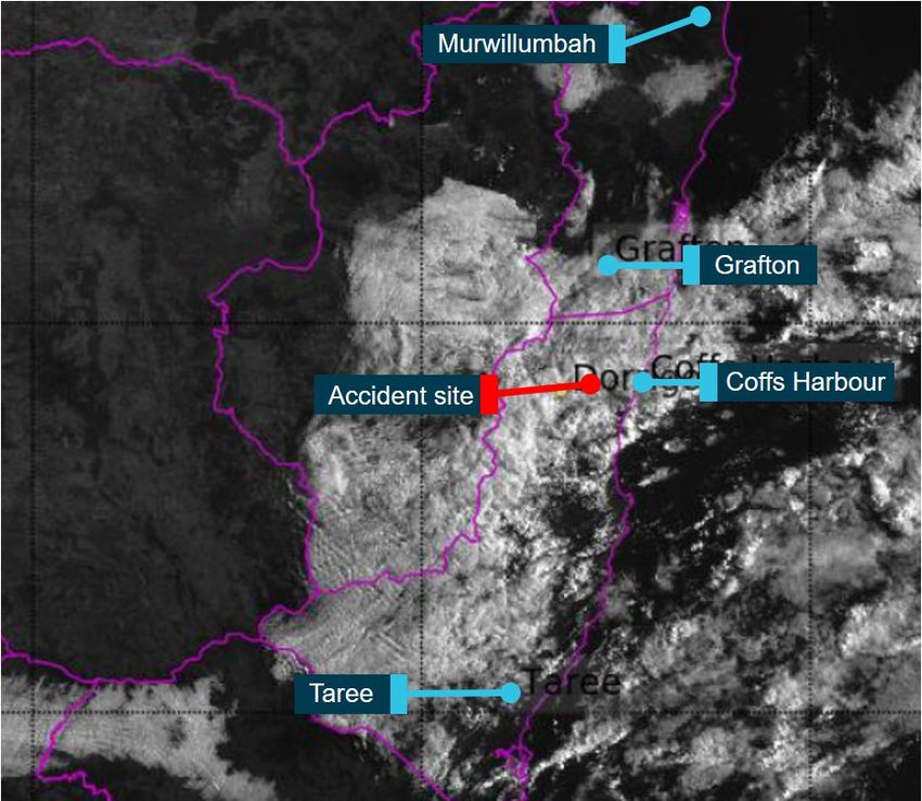
ATSB – AO-2019-052
The pilot subsequently contacted the Class D controller in the Coffs Harbour air traffic control
tower and requested a clearance. In response, the tower controller contacted the Brisbane Centre
Class C controller to discuss and coordinate the aircraft’s transit. Following that discussion, at
about 0721, the tower controller advised the pilot that due to the extensive cloud cover, ‘the only
way’ to transit that airspace under the VFR would be at an altitude not above 1,000 ft. The pilot
responded that the aircraft would descend to ‘not above 1,000 ft’.
Recorded air traffic surveillance data indicated that at about this time, the pilot manoeuvred the
aircraft slightly further laterally away from the Class C airspace however, during the descent, it
briefly entered that airspace without a clearance.
The aircraft then continued on a direct track outside controlled airspace (OCTA) towards Taree
and at 0724, the pilot advised the tower controller the flight was ‘currently 4100 in clear and we’re
OCTA’. In the context of the preceding discussion regarding the extent of the cloud, the ATSB
assessed the pilots reference to ‘in clear’ was an indication that the aircraft was operating in clear
weather conditions at an altitude of 4,100 ft at that time. The pilot also advised that the flight would
continue on that track and that a clearance request would be made upon reaching the airspace
boundary (the aircraft’s track intersected further Class D controlled airspace to the south of Coffs
Harbour). The tower controller acknowledged this and asked that the pilot report entering
controlled airspace.
A review of recorded air traffic control surveillance data showed that after the pilot reported that
the flight was operating in clear conditions, the aircraft was climbed to about 4,500 ft in Class G
uncontrolled airspace and continued on a direct track until 0732. At that time, the aircraft
commenced a descent, which continued until the last recorded position about 1 minute later. The
aircraft was last recorded descending through an altitude of 3,564 ft at a ground speed of 165 kt.
No further position or radio broadcasts were received from the aircraft.
In response to the aircraft not arriving at Taree as expected, a search was initiated. Although the
search was initially hampered by rain and low cloud in the vicinity of the aircraft’s last known
position, the aircraft was located, having impacted terrain at an elevation of 2,920 ft. The
wreckage was positioned in line with the last recorded track and about 2.8 km south of the last
recorded position. The two persons on board were fatally injured and the aircraft was destroyed
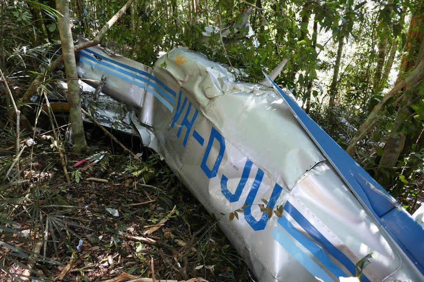
(Figure 2).
Figure 2: Accident site
Source: ATSB
›2 ‹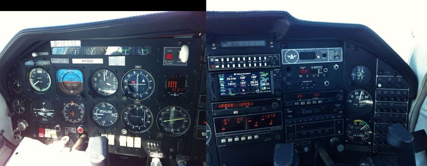
ATSB – AO-2019-052

Context
Pilot information and training
The pilot obtained a Civil Aviation Regulation 1988 Regulation 5 (CAR 5) Private Pilot Licence
(Aeroplane) in 1982. For that licence, the pilot held endorsements for single engine aircraft below
5,700 kg maximum take-off weight, manual propeller pitch control, retractable undercarriage, tail
wheel undercarriage and operation in controlled airspace. The pilot had never held an instrument
rating.
The pilot was reported to have kept an up to date logbook but it was not found at the accident site
or located during the investigation. An earlier logbook provided to the ATSB, contained two
entries, including one relating to the conduct of a flight review in January 2010. The pilot had
declared a total aeronautical experience of 1,006 hours at their last medical examination in
November 2017.

Licencing and flight reviews under CASR Part 61
In September 2014, the Civil Aviation Safety Authority (CASA) introduced new flight crew licencing
regulations, Civil Aviation Safety Regulation 1998 (CASR) Part 61. As part of the transition to the
new licencing system, pilots could continue to exercise the privileges of their CAR 5 licence until
31 August 2018. Between September 2014 and 31 August 2018, pilots were required to make an
application for a new Part 61 licence in conjunction with their next required flight review or
proficiency check.
From 1 September 2018, CASA ceased recognising CAR 5 licences and a pilot was required to
hold a CASR Part 61 licence in order to conduct a flight.
Prior to conducting a VFR private flight, CASR Part 61 required an aeroplane flight review (AFR),
or other specified proficiency check, to have been undertaken within the previous 2 years.
The CASA Flight reviews information sheet provided the following guidance on the purpose and
benefits of flight reviews:
      A flight review is an opportunity to receive training that refreshes your flying skills and operational
      knowledge. Pilots undertake flight reviews to ensure they continue to be competent flying particular
      types of aircraft or exercising the privileges of an operational rating.
      After gaining a qualification, it is normal for some skills to deteriorate over time. A flight review ensures
      your piloting skills remain - or are brought back up - to standard.

During an AFR, a pilot is required to demonstrate competency as outlined in the Part 61 manual of
standards. The AFR also serves as an opportunity for a pilot to receive training to attain the
required standards.
The manual of standards included the following competencies which were relevant to the
management of hazards associated with the accident flight:
      2.2 3 (d) perform diversion procedure
      2.5 5 (a) perform basic flight manoeuvres using full instrument panel
      2.7 7 (a) recognise and manage threats and errors during pre-flight planning and in-flight;
      (b) maintain effective lookout and situational awareness;
      (c) assess situations and make appropriate decisions;
      (d) set priorities and manage tasks;
      (e) maintain effective communication with stakeholders;
      (f) communicate effectively using aeronautical radio.
      4 (c) obtaining, interpreting and applying meteorological and aeronautical information;

                                                      ›3 ‹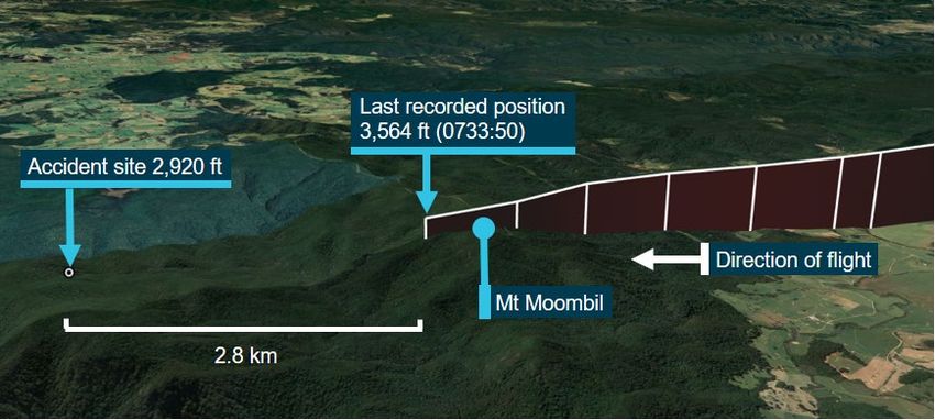
ATSB – AO-2019-052

      (d) navigation and flight planning for day VFR operations;
      (j) hazard identification and risk management;
      (m) hazardous weather;

Prior to the introduction of CASR Part 61, flight reviews were only required to be recorded in a
pilot’s logbook. After the introduction of CASR Part 61, flight reviews and proficiency checks were
required to be recorded in a pilot’s licence, logbook and with CASA. As the pilot’s current logbook
was not recovered during the investigation, the date of any flight review after January 2010 and
before September 2014 could not be determined.
However, CASA did not hold any record of an application for a flight review or equivalent
proficiency check after September 2014. The ATSB contacted flying training organisations at
Murwillumbah Airfield and Gold Coast Airport, where the pilot’s previous aircraft was maintained
and the pilot was reported to have regularly visited. None of these organisations held training
records for the pilot.
Based on the available information, the ATSB concluded that the pilot had not met the CASR Part
61 flight review requirements and, as such, did not hold the required licence to undertake the
flight.

Fatigue
The ATSB collected information about the pilot’s 72 hours of activity prior to the accident. A review
of that evidence identified that it was unlikely that the pilot was experiencing a level of fatigue
known to affect performance.

Medical and pathological information
The pilot held a Class 2 medical certificate valid until November 2019.
Two prescription medications belonging to the pilot were found in the wreckage and the pilot’s
toxicology report confirmed the presence of both medications. The use of one of those
medications was not recorded in the pilot’s medical file held with CASA. It is unlikely that this
medication adversely affected the pilot’s performance during the accident flight.
CASR Part 67 describes the requirements for aviation medical certification. One of the criteria for
exercising the privilege of a Class 2 medical certificate is that the use of ‘any over‑the‑counter or
prescribed medication or drug… that causes the person to experience any side effects likely to
affect the person to an extent that is safety‑relevant’ is prohibited.
Further, medical certificate applicants are required to answer ‘every question asked by the
examiner that the examiner considers necessary to help…CASA decide whether the applicant
meets the relevant medical standard’. They are obliged to notify CASA of changes in medical
conditions that impair their ability to ‘do an act authorised by the license’.
The following extracts from CASA-developed brochures are particularly relevant to pilot medical
examinations.
      Designated aviation medical examiners (DAMEs) and pilots together should foster a culture where it is
      likely that pilots will feel comfortable disclosing medical problems, even if they may impact on their
      ability to maintain an aviation medical.
      Your DAME…will expect you to answer both written and verbal questions, honestly and fully...

Under the clinical practice guidelines for DAMEs, certain risk assessment protocols allowed them
to take into account the pilot’s need for medication use when assessing if the applicant met the
relevant medical standard. A CASA brochure states ‘only 0.29 percent of all initial and renewal
medical certificates were refused by CASA during 2016-2017’.

                                                    ›4 ‹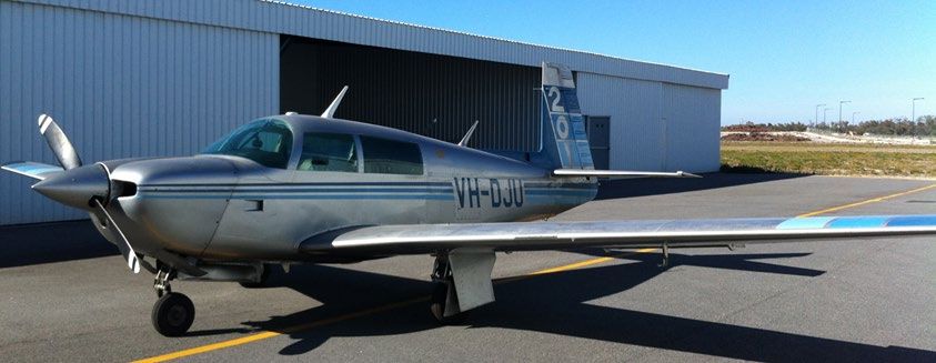
ATSB – AO-2019-052

Aircraft information
The Mooney M20J is a four seat, piston-engine aircraft with a two-blade variable-pitch propeller
and retractable tricycle landing gear. VH-DJU (serial number 24-1075, Figure 3) was
manufactured in 1981 and first registered in Australia in 2005. 3
Figure 3: The aircraft, VH-DJU

Source: Previous aircraft owner

The pilot purchased the aircraft on 6 July 2019, about 3 months prior to the accident, and had
flown about 31 hours in the aircraft. The most recent entry on the maintenance release was
11 days prior to the accident (9 September 2019) and showed that the aircraft had accumulated
3,295 hours total time‑in‑service.
At the last scheduled maintenance inspection, in December 2018, the required inspections and
test of the pitot-static system 4 to maintain the aircraft’s approval for instrument flight rules (IFR) 5
operation were not undertaken. However, as a condition of purchasing the aircraft, the pilot of the
accident flight required that the test and inspections be carried out. In April 2019, this was carried
out and at the time of the accident the aircraft was equipped and approved for IFR operation
(Figure 4).
Figure 4: Composite image of the instrument panel

Source: Supplied

3
    Prior to being registered in Australia, the aircraft was operated in South Africa.
4
    The pitot-static system is a system of air pressure-sensitive sensors and instruments that are used to determine an
    aircraft's airspeed, altitude, and vertical speed.
5
    Instrument flight rules (IFR): a set of regulations that permit the pilot to operate an aircraft to operate in instrument
    meteorological conditions (IMC), which have much lower weather minimums than visual flight rules. Procedures and
    training are significantly more complex as a pilot must demonstrate competency in IMC conditions while controlling the
    aircraft solely by reference to instruments. IFR-capable aircraft have greater equipment and maintenance requirements.
                                                            ›5 ‹
ATSB – AO-2019-052
The aircraft was equipped with an autopilot capable of maintaining a selected heading and
navigation track. The autopilot did not have an altitude hold function or ability to manipulate the
vertical flight profile.
Two smartphones and a tablet computer were recovered from the wreckage. Neither smartphone
contained an electronic flight bag or other aviation application. The tablet computer was found
packed in an overnight bag indicating that it was not used during the flight.
Date-expired air navigation charts for the area encompassing the flight were found stowed in a
flight bag indicating that they were not being used at the time of the accident. No paper flight plan
or other flight planning notes were located in the wreckage.
Global Navigation Satellite System units
Passengers who had flown with the pilot reported that the pilot routinely used a Garmin Aera 500
Global Navigation Satellite System (GNSS) 6 unit carried in their lap. The aircraft was also
equipped with a Garmin GTN650 GNSS unit.
Aera 500
The Aera 500 unit carried by the pilot was not approved as a sole means of navigation. However,
the unit did present useful information relating to the progress of the flight. This included
topographical and airspace information. The unit had a terrain function that required a valid 3D
GNSS position solution and a valid terrain and obstacle database to operate properly. Terrain
information was advisory only and could include:
• display of altitudes of terrain and obstructions relative to the aircraft’s altitude
• pop-up terrain alert messages issued when flight conditions meet parameters set within the
terrain system software algorithms
• forward looking terrain avoidance alerts
The ATSB recovered data from this unit indicating that it was in use at the time of the accident.
However, it could not be established which mode was selected at the time of the accident or
whether the terrain function was operable and the status of any user and system inhibitions.
GTN650
The GTN650 unit fitted to the aircraft operated as both a radio communications unit and an
IFR-approved GNSS unit. The unit was capable of operating in different modes, which could
display a significant amount of information relating to progress of the flight. This included the
selected track, any deviation from this track, topographical, and airspace information.
Like the Aera 500, the GTN650 had a terrain function. The unit provided similar advisory
information and alerts as the Aera 500 unit with similar limitations. The previous owner of the
aircraft, a flying instructor, advised the ATSB that at the time of the pilot’s purchase of the aircraft,
the pilot declined familiarisation training with the GTN650 unit as the Aera 500 would be used. It
could not be determined if the pilot subsequently undertook user training for the GTN650 unit.
The ATSB was not able to recover any data from the GTN650 unit to determine if it was used
during the accident flight.
Terrain in the accident vicinity
At the time of the request to transit Class C airspace, the aircraft was about 10 NM north of
Grafton (Figure 5). The area to the north of and surrounding Grafton was low-lying coastal terrain
with elevations generally below 1,000 ft AMSL. However, the line of hills associated with the Coast
6
Global Navigation Satellite System: A satellite-based radio navigation system that uses signals from orbiting satellites
to determine precise position and time.
›6 ‹ATSB – AO-2019-052
Range, between the aircraft’s position and a track toward the coast and Coffs Harbour, rose to
elevations in excess of 1,000 ft AMSL.
Figure 5: World Aeronautical Chart extract showing terrain in the vicinity of the aircraft’s
track
Source: ATSB
Along a direct track toward Taree, the aircraft’s path passed over a region where the Great
Dividing Range extended near to the coast at Coffs Harbour. This area included the mountain
range encompassing Dorrigo National Park. The topography within this region was substantially
more rugged and elevated than the terrain further north, rising in excess of 3,000 ft AMSL.
The terrain over which the aircraft was flying at the time of the descent from 4,500 ft was within
this mountain range. The highest obstacle near the aircraft’s track were two towers on Mount
Moombil at 3,950 ft, 400 m east of the track. Immediately south of Mount Moombil was a broad
valley, which rose on the southern side to a ridge. The highest point of the ridge was 3,018 ft.
Meteorology
Airservices Australia (Airservices) did not hold any National Aeronautical Information Processing
System (NAIPS) 7 login records for the pilot for that, or any past, flights. A review of the pilot’s
7
The National Aeronautical Information Processing System (NAIPS) is a computerised, aeronautical information system.
It processes and stores meteorological and NOTAM information as well as enables the provision of briefing products
and services to pilots.
›7 ‹ATSB – AO-2019-052
personal electronic devices identified that there were no aviation flight planning or aviation
weather applications and no weather documentation relevant to the accident flight was found in
the wreckage.
The ATSB obtained relevant weather information from the Bureau of Meteorology (BoM).
BoM information
Graphical area forecast
The graphical area forecast for the accident region forecast the following cloud conditions for the
time of the accident (all heights AMSL):
• broken 8 stratus between 1,000-2,000 ft
• broken stratocumulus between 2,000-4,000 ft
• scattered cumulus between 4,000-9,000 ft
Satellite images
Satellite images (Figure 6) for the area just prior to the accident time showed generally clear
conditions between Murwillumbah and Grafton. South of Grafton and throughout the area
encompassing the high terrain west of Coffs Harbour, the images showed extensive cloud
coverage. Further along the intended route towards Taree, the cloud coverage reduced near the
coast, but persisted inland.
8
Cloud cover: in aviation, cloud cover is reported using words that denote the extent of the cover – ‘few’ indicates that up
to a quarter of the sky is covered, ‘scattered’ indicates that cloud is covering between a quarter and a half of the sky,
‘broken’ indicates that more than half to almost all the sky is covered, and ‘overcast’ indicates that all the sky is
covered.
›8 ‹ATSB – AO-2019-052
Figure 6: Meteorological satellite image extract for 0730 on 20 September 2019
Source: Bureau of Meteorology, annotated by ATSB
Analysis
The BoM provided the following analysis of meteorological conditions for the Coffs Harbour region
on the morning of the accident:
On the 19th of September 2019, the analysed mean sea level pressure (MSLP) chart for 1800 UTC
(4 am AEST 20th September) showed a strong, slow moving high pressure system over the Tasman
Sea extending a ridge over eastern New South Wales. A coastal trough situated north of Coffs
Harbour, whilst an approaching cold front was moving east through Central Australia at approximately
30 knots.
At the time of the incident the region was covered in widespread broken low cloud. With bases
generally between 2000 - 3000ft above mean sea level, this most likely resulted in cloud on ground
around Mount Moombil. Recent rainfall over the area with persistent onshore flow likely increased the
low-level moisture within the air mass, creating saturated conditions.
The top of the broken low cloud layer was approximately 3,000 (±1,000) ft AGL [above ground level]
with a second cloud layer, few to scattered in its extent and at approximately 8,000 (±1,000) ft AGL.
Automatic terminal information service
At the time of the accident, the Coffs Harbour automatic terminal information service detailed the
following weather information:
• wind: Variable at 5 kt
• visibility: Greater than 10 km
›9 ‹ATSB – AO-2019-052
• cloud coverage: Few at 1,500 ft and broken at 2,500 ft 9
• temperature: 17° C
Witness
A witness located about 10 km south-east of the accident site stated that cloud was ‘down to the
ground’ at the base of the mountain from 0700 until 0830 on the morning.
Visual meteorological conditions
Visual meteorological conditions (VMC) are the minimum meteorological conditions in which flight
is permitted under the VFR – that is, conditions in which pilots have sufficient visibility to fly the
aircraft while maintaining visual separation from terrain and other aircraft. Additionally, when
operating VFR at or below 2,000 ft above the ground or water, the pilot must be able to navigate
by visual reference to the ground or water.
The VMC requirements for aeroplanes vary for different classes of airspace (Table 1).
Table 1: Visual meteorological conditions
Airspace Flight Distance from Additional conditions
visibility cloud
Class C below 10,000 ft 5,000 m 1,500 m horizontal ATC may permit operations in
AMSL 1,000 ft vertical weather conditions that do not meet
this criteria (special VFR)
Class D 5,000 m 600 m horizontal ATC may permit operations in
1,000 ft vertically weather conditions that do not meet
above; or 500 ft this criteria (special VFR)
vertically below
Class C & D Special VFR 1,600 m Clear of cloud Operate within the requirements of
Civil Aviation Regulation 157 Low
flying.
Class G below 10,000 ft 5,000 m 1,500 m horizontal
(subject to below) 1,000 ft vertical
Class G at or below 5,000 m Clear of cloud and Radio must be carried and used on
(whichever is the higher) of: in sight of ground the appropriate frequency
(a) 3000 ft AMSL; or water
(b) 1000 ft AGL
Source: Aeronautical Information Publication ENR 1.2
Airspace and airways clearances
Coffs Harbour airspace
Coffs Harbour Airport is situated within Class D terminal airspace (Figure 7). This airspace was
controlled by an air traffic controller situated within the Coffs Harbour control tower. The Class D
airspace extended to the north and south-west at ground level to a 7 NM boundary. West of the
airport, the airspace extended about 6 NM and further west of this boundary, the controlled
airspace base was the overlying Class E airspace at 8,500 ft. 10 To the north and south-west, the
airspace fanned out at increasing distances from Coffs Harbour. The base of the airspace also
progressively stepped up at increasing distances to a maximum altitude of 4,500 ft at about
22 NM.
9
Cloud heights are above ground level.
10
For VH-DJU, a clearance was not required to transit the Class E airspace.
› 10 ‹ATSB – AO-2019-052
Figure 7: Visual terminal chart extract of Coffs Harbour airspace showing key events
Source: Airservices Australia, annotated by ATSB.
Overlying the Class D airspace was Class C en route airspace, which continued up from 4,500 ft
to overlying Class A airspace at flight level (FL) 180. 11 The Class C airspace was controlled by an
air traffic control position situated in Brisbane. At the time of the accident, this position was
occupied by a trainee controller (trainee) in the first week of on-the-job training and under the
supervision of an on-the-job training instructor (OJTI). The trainee and OJTI were managing both
the sector of Class C and uncontrolled Class G airspace overlying and surrounding Coffs Harbour
(Grafton) combined with a second sector of Class C and Class G airspace (Newell) extending to
the west over the New England region.
The base of the Class C airspace also fanned out and progressively stepped up at further
distances from Coffs Harbour Airport. At a distance of about 30 NM, where the pilot of DJU
11
Flight level: at altitudes above 10,000 ft in Australia, an aircraft’s height above mean sea level is referred to as a flight
level (FL). FL 180 equates to about 18,000 ft.
› 11 ‹ATSB – AO-2019-052
requested to enter the airspace, the base of the Class C airspace was 5,500 ft. Outside of these
boundaries was Class G uncontrolled airspace that extended up to the base of overlying Class A
airspace at FL 180.
Within Class C airspace, aircraft were identified and controlled using automatic dependent
surveillance broadcast (ADS-B) or radar surveillance data. IFR aircraft were positively separated
from both IFR and VFR aircraft. VFR aircraft were provided traffic information about other VFR
aircraft. The controllers had access to relevant weather forecasts and observations, but as they
were physically located in Brisbane, they could not see the actual weather conditions.
In addition, Class C controllers provided pertinent operational information to IFR aircraft as well as
to VFR aircraft upon request within the Class G airspace.
Within Class D airspace aircraft were not identified and controlled using surveillance data, and
separation between aircraft was provided as follows:
• IFR flights were separated from other IFR and special VFR flights, 12
• IFR flights were provided traffic information for VFR flights,
• VFR flights were provided traffic information on other VFR flights, and
• special VFR flights were separated from other special VFR flights in conditions less than VMC.
The Class D controller at Coffs Harbour Airport had access to weather forecasts, observations
and could observe the prevailing weather conditions for the airspace. In addition, the control tower
was fitted with a tower situation awareness display (TSAD). This displayed ADS-B and radar
aircraft position information to enhance controller awareness, but was not used for traffic
management or separation.
Flight notification
The pilot was not required to and did not submit a flight plan prior to departure.
As the pilot intended to operate in the Class C airspace, notification of the flight was to be
provided to ATC as per Airservices’ Aeronautical Information Publication (AIP) requirements. The
pilot provided this notification when the aircraft was 10 NM north of Grafton (about 4 minutes prior
to reaching the airspace boundary), with detail of the intended track and a clearance request to
transit the Class C airspace.
Traffic
At the time of the Class C clearance request, there was no other traffic below 10,000 ft in the Coffs
Harbour airspace, nor were there any impending arrivals or departures during the time the aircraft
would have transited the airspace. Within the remaining airspace being managed by the trainee
and OJTI, there were five other aircraft being provided an air traffic service.
Additionally, in the minute prior to receiving the request from VH-DJU, the trainee had completed
handling a flight following request from a VFR aircraft.
Class C clearance request
The pilot requested a clearance to proceed from a position 10 NM north of Grafton (14 NM from
the airspace boundary) direct to Taree at an altitude of 6,500 ft. This track passed within the
Class C airspace for a distance of about 7 NM (2 minutes and 50 seconds at the aircraft’s speed).
On receiving the clearance request, the trainee assessed that workload and priorities would not
permit a clearance at the requested level, and that the transit would be better facilitated through
the underlying Class D airspace. The trainee then advised the pilot accordingly, providing the
option to request clearance for the Class D airspace. The trainee or OJTI did not contact the Class
12
By day, when VMC does not exist, air traffic control may authorise, at pilot request, a ‘special VFR’ flight for the purpose
of entering or leaving the controlled airspace.
› 12 ‹ATSB – AO-2019-052
D controller prior to initially proposing the pilot contact that controller. The OJTI felt that it was
more effective for the pilot to contact the Class D controller directly rather than coordinating the
request.
Workload assessment
The Airservices investigation report into the accident identified the following:
Sampling of Grafton sector controller performance assessment reports and daily training records
included debriefing and coaching comments emphasising to trainees and controllers to be cautious
with issuing clearances below A080 through the [Coffs Harbour] airspace. These comments are
intended to highlight the known complications of transiting aircraft with processing IFR departures and
arrivals. Techniques including the use of alternative clearances for departing and overflying aircraft
are also emphasised during training and checking together with options for transiting aircraft to
climb/descend to transit the airspace to manage the traffic scenarios. Assessing the options available
with regard to the traffic picture is also emphasised during training and checking.
While acknowledging the complexities during training and checking is appropriate, this may unduly
influence decision-making particularly in trainees and inexperienced controllers as they gain
confidence and familiarity with new airspace volumes. In these cases, perceived workload may be
prioritised ahead of an appropriate assessment of the current and projected traffic disposition.
The OJTI assessed that the workload at the time of the clearance request was low, but the trainee
being new to the role may have perceived the workload as higher. The OJTI also stated that while
the trainee’s decision was conservative, it was appropriate. The OJTI felt no intervention was
required as the pilot had been provided a suitable option. The OJTI further stated that 6,500 ft was
a level that created separation difficulties with Coffs Harbour arrivals and departures, and given
the limited size of the airspace this can very quickly create a significant workload issue.
Class C airspace infringement
After being advised that a Class C clearance was not available, the aircraft entered the Class C
controlled airspace without clearance. After entering the controlled airspace, the pilot descended
the aircraft before exiting the airspace about 1 minute later (see the section titled Class D
clearance request and communications below).
The trainee did not attempt to contact the pilot of the aircraft during the airspace infringement. The
OJTI noted that this airspace infringement did not cause any separation or traffic management
concerns.
Class D clearance request and communications
The direct track to Taree from the pilot’s position did not intersect the northern sections of the
Class D airspace and therefore a clearance was not required on the direct track at or below
4,500 ft. However, the track did intersect the southern section of the airspace beyond Coffs
Harbour.
The pilot requested a clearance with the Class D controller for a transit at 6,500 ft on a direct track
to Taree. This flight path would have transited the Class C airspace and the Class D controller,
queried whether the pilot wanted to remain at 6,500 ft. The pilot stated being ‘happy to remain at
6,500 ft’ and the controller, unaware of the previous Class C clearance request, instructed the pilot
to contact the Class C controller for a clearance through that airspace.
The Class D controller then contacted the trainee to advise that the pilot would be calling them to
request the clearance through the Class C airspace and that they wanted to transit at 6.500 ft. The
Class D controller informed the trainee that a VFR transit would be difficult. During this discussion
between the controllers, the pilot again contacted the Class C controller for the clearance.
The trainee advised the pilot that the Class D controller had been in contact, and instructed the
pilot to again contact that controller.
› 13 ‹ATSB – AO-2019-052
At 0721, the pilot again contacted the Class D controller. The Class D controller advised that a
clearance through the Class D airspace would only be available ‘about not above 1,000 ft’ and the
pilot responded that the flight would descend to that level. The Class D controller asked the pilot to
report entering the airspace at the 7 NM boundary. While a change in track was required to enter
the airspace at the 7 NM boundary, no tracking instruction or guidance was provided to the pilot.
The pilot did not voice any concerns about the advice provided by the Class D controller.
At 0724, about 10 minutes prior to the accident, the pilot contacted the Class D controller and
advised that the flight was operating outside controlled airspace, in clear conditions at
4,100 ft AMSL, would remain on that track and request a clearance upon reaching the airspace
boundary. No clearance was issued by the tower controller but the controller acknowledged the
request and instructed the pilot to report entering controlled airspace. No further broadcasts were
heard from the aircraft.
Seventeen minutes later, at around the time the controller expected the pilot to enter controlled
airspace (and about 7 minutes after the accident had occurred), the Class D controller tried
contacting the pilot twice without receiving a response.
Uncertainty phase not declared
Aircraft to the west of Coffs Harbour were known to disappear from the TSAD (as DJU did about
1 minute prior to the accident) due to the effect of the surrounding terrain. It was also common for
VFR aircraft to be uncontactable by Coffs Harbour ATC when operating in Class G airspace in
that area. The controller reported that, as the pilot had advised that the flight was operating in
clear conditions at 4,100 ft, they held no concern for the progress of the flight. Consequently, no
uncertainty phase was declared with respect to the flight. 13
Fatigue
The ATSB found no indicators that increased the risk of the controllers experiencing a level of
fatigue known to affect performance.
Future Coffs Harbour airspace reclassification
Prior to the accident, Airservices commenced the Airspace Modernisation Program. This program
will reclassify the Class C airspace above Coffs Harbour to Class E. At the time of writing, the
timeframe for the completion of this program was not available.
Undertaking a VFR transit of the Class E airspace will not require a clearance.
Recorded flight data
The aircraft was not required to be and was not fitted with flight data recorders.
Airservices provided ADS-B and radar surveillance data relating to the flight. The data captured
the flight from soon after departure at Murwillumbah until about 2.8 km north of the accident site
(Figure 8).
13
Uncertainty Phase: A situation where uncertainty exists as to the safety of an aircraft and its occupants.
› 14 ‹ATSB – AO-2019-052
Figure 8: Recorded flight path near accident site (towers on Mt Moombil not depicted)
Source: Google Earth annotated by ATSB
From 0722 until 0724, the aircraft descended from its cruising altitude of 6,500 ft to 4,100 ft. At this
time, the pilot reported operating in clear conditions. About 2 minutes later, the aircraft climbed to
4,500 ft.
The aircraft remained at 4,500 ft until 0732 when a descent commenced and continued until the
last recorded position at 0733:50. The descent rate averaged about 850 ft per minute with a
groundspeed between 165 kt and 175 kt. The observed wind was almost directly across the
descent track at 10-20 kt. According to the aircraft’s previous owner, this descent profile was
consistent with maintaining a cruise engine power setting.
During this descent, the aircraft passed a saddle about 400 m west of the summit of Mount
Moombil. On top of the summit were two towers, 538 ft high. The aircraft passed about 386 ft
below the top of these towers and continued descending across a broad valley. Throughout the
descent, no significant variations in either aircraft track, speed or descent rate were recorded
Data recovered from the pilot’s Aera 500 GNSS unit was similar to the surveillance data until
3 minutes prior to accident (about 1 minute before the final descent) when the recorded data
ended. The ATSB’s examination of the unit determined that the data loss was most probably the
result of power supply interruption during the accident sequence, before that data was recorded to
the non-volatile memory.
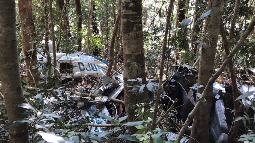
Accident site and wreckage
The accident site was located at an elevation of 2,920 ft in heavily wooded, steep terrain within
Dorrigo National Park (Figure 9).
› 15 ‹ATSB – AO-2019-052
Figure 9: Aircraft wreckage
Source: ATSB
The path made by the aircraft through the vegetation continued for about 65 m from the first
identified aircraft component to the ground impact point (Figure 10). Tree-impact marks and the
impact crater showed that the aircraft entered the vegetation in a wings-level attitude on a
continuation of the previously recorded descent angle of about 2°.
Examination of the wreckage found that the aircraft entered the vegetation at relatively high speed
with the flaps and landing gear retracted. No pre-impact faults were identified, but the examination
was limited by the extensive damage. The serviceability of the flight instruments and associated
systems could also not be verified. Both fuel tanks ruptured and an odour of fuel was present. The
engine separated from the fuselage and the engine controls were severely disrupted during the
accident sequence, which prevented determination of their positions. Damage to the propeller
indicated that it was being driven by the engine at the time of the accident. The accident was not
survivable.
› 16 ‹ATSB – AO-2019-052
Figure 10: Final descent path of the aircraft
Source: ATSB
Similar occurrences
The safety risks of visual pilots flying into non-visual conditions are well documented and continue
to represent a significant factor in aircraft accidents and fatalities.
Many similar occurrences have been summarised in the ATSB research reports General Aviation
Pilot Behaviours in the Face of Adverse Weather and Accidents involving Visual Flight Rules pilots
in Instrument Meteorological Conditions as well as in ATSB accident reports, including
AO-2017-061 and AO-2017-069.
A large amount of reference material is available to pilots for guidance on avoiding VFR flight into
adverse weather as well as recovering a flight should inadvertent IMC entry occur, including by
› 17 ‹ATSB – AO-2019-052
seeking the assistance of ATC. The United States Aircraft Owners and Pilots Association Air
Safety Institute website VFR into IMC provides an online course, videos and reference materials
to assist pilots in avoiding and managing these scenarios. The following articles also provide
valuable guidance on the subject.
• AVweb, Surviving VFR into IMC.
• Plane & Pilot, Surviving inadvertent IMC.
› 18 ‹ATSB – AO-2019-052
Safety analysis
Introduction
On the morning of 20 September 2019, while en route from Murwillumbah to Taree, New South
Wales, a Mooney M20J, registered VH-DJU (DJU) descended into an area of low visibility and
high terrain near the town of Dorrigo. During this descent, the aircraft collided with steep, forested
terrain within Dorrigo National Park.
A review of the pilot’s medical records, post‑mortem toxicology results and recorded data
indicated that it was very unlikely that the pilot became incapacitated during the flight. While
examination of the wreckage was limited by extensive damage, no defects or anomalies were
identified that contributed to the accident. As such, this analysis focuses on the examination of the
operational factors that led to the aircraft’s collision with terrain while being operated under the
visual flight rules (VFR).
Class C clearance request
At 0717, about 4 minutes prior to reaching the Class C airspace north of Coffs Harbour, the pilot
notified the controller (in Brisbane) of their intended track and requested clearance to transit the
airspace. The intended transit would be short (7 NM, less than 3 minutes) and there was no other
aircraft in the Class C or D airspace overlying Coffs Harbour, or any impending departures or
arrivals there.
The aircraft was cruising at 6,500 ft and the pilot reported being ‘happy’ at that altitude, indicative
of the visibility and conditions at the time. Based on the Bureau of Meteorology (BoM) analysis of
the cloud conditions, the ATSB assessed that a VFR transit of the airspace at or above 6,500 ft
was possible.
At the time the transit clearance request was made, the trainee controller (trainee) controlling the
Class C airspace was managing five aircraft across two airspace sectors and had just completed
handling another request. The trainee assessed that the workload would not allow the clearance
requested for DJU and advised the pilot that it was not available and to contact the Coffs Harbour
control tower to transit via the underlying Class D airspace.
The supervising on-the-job training instructor (OJTI) felt that the trainee’s perception of workload
was higher than it actually was, but it was a conservative assessment and appropriate given the
trainee’s experience (within the first week of on-the-job training). In any case, the OJTI was
satisfied with the trainee’s handling of the request as the decision to not provide a clearance was
not considered unsafe and the pilot had been provided with an appropriate alternative.
The trainee and the OJTI also reported considering that the requested 6,500 ft transit may create
separation difficulties with aircraft departing Coffs Harbour Airport under instrument flight rules.
However, at the time there was no traffic expected to or from the airport. Additionally, a review of
the available evidence indicated that there were no meteorological factors, traffic control
instructions or procedures that prevented the pilot of DJU being provided with a clearance.
When DJU subsequently infringed Class C airspace as it descended, the trainee took no action
and the OJTI felt the infringement did not present any traffic management issues. This indicates
that the clearance requested could have been accommodated without any significant increase in
controller workload.
Acceptance of the ATC option to seek a clearance through Class D airspace resulted in the pilot
deviating from their intended plan and commenced a sequence of events that ultimately
culminated in the accident. However, it is also important to recognise that the pilot had other
available safe courses of action that were not utilised (discussed further below) and the ultimate
outcome could not have been anticipated.
› 19 ‹ATSB – AO-2019-052
Decision to descend
When communicating with the Coffs Harbour tower controller to transit the Class D airspace, the
pilot reported being ‘happy at 6,500 ft’. An assessment of the BoM cloud conditions analysis
indicated that visual meteorological conditions (VMC) allowed the flight to progress at and above
that altitude or below about 2,000 ft, but extensive cloud cover probably prevented VMC flight
between those two levels. The analysis also indicated that it was possible to proceed in VMC
around the Class C controlled airspace at or above 6,500 ft. Conditions also permitted a diversion
or descent to the north of Grafton to proceed coastal beneath the cloud layers south to Taree.
In response to the pilot’s request, the Class D controller advised that ‘…the only way you could
transit this airspace VFR would be around… not above one thousand [feet]’. The pilot responded
that the flight would descend to ‘not above 1,000 ft’ and commenced a descent from 6,500 ft.
The controller had also requested that the pilot report at the 7 NM airspace boundary to receive a
clearance, but had not provided any tracking information. Given the aircraft’s position at the time,
the pilot would have had to change track to reach that boundary.
At altitudes less than 1,000 ft along a track between the aircraft’s position and Coffs Harbour
Airport and more significantly, along a continuation of the direct track to Taree, terrain clearance
was not possible. However, the pilot did not voice any concerns with the advice provided and the
flight descended on the direct track to Taree.
While it was the pilot’s decision to descend from 6,500 ft and continue along the direct track
instead of other available safe options, this decision was likely influenced by the information
provided by the controller. The descent took the aircraft toward both significant cloud and high
terrain, increasing risk to the flight.
Pre-flight preparation
Although out-of-date, the aeronautical charts carried by the pilot showed the high terrain west of
Coffs Harbour. However, the pilot was not using the charts at the time of the accident. Additionally,
an electronic flight bag program was not used to provide topographical information. The pilot was
heavily reliant on the global navigation satellite system units for situational awareness, but the
limitations of these units may have prevented them from displaying adequate terrain information.
There was no evidence that the pilot obtained weather information prior to departure or during the
flight, nor was any weather information found in the wreckage. As the weather encountered during
the flight was similar to forecast, this information would have provided the pilot with advance
notice of the likely conditions and supported more effective decision-making.
In summary, the pilot probably did not have an adequate understanding of the weather conditions
or awareness of the topography west of Coffs Harbour. These factors reduced the pilot's ability to
manage the flight path changes and identify the high terrain into which the aircraft was
descending.
Flight into unsuitable conditions
The BoM analysis indicated that conditions across the mountain range west of Coffs Harbour at
the time of the accident were below the minimum stipulated for VMC. This is consistent with the
account of a witness located 10 km south-east of the accident site.
About 8 minutes after reporting that the aircraft was operating in clear conditions, surveillance data
showed that the aircraft commenced a descent. Given the weather conditions in this area, it is
possible that the pilot initiated this descent to remain clear of cloud (to comply with the VFR) as it
is a pilot’s responsibility to ensure VFR flights operate in accordance with VMC.
During the descent, the aircraft passed about 400 m to the west of and about 386 ft below the top
of two towers at the summit of Mount Moombil. At or after that time, no significant change in flight
› 20 ‹ATSB – AO-2019-052
path was recorded, which suggests that the aircraft had encountered poor visibility and/or these
towers were not sighted.
The aircraft’s path through the vegetation to the final impact point was a continuation of the
previous descent angle and track. This indicates that the flight was under control until the collision
and that the pilot was unable to identify the high terrain in the aircraft’s path in sufficient time to
take avoiding action.
Flight reviews
An aeroplane flight review (AFR) is required every 2 years for a pilot to exercise the privileges of a
flight crew licence. A current logbook was not located during the investigation, a previous logbook
contained the only recorded flight review undertaken by the pilot, in January 2010. As the pilot had
not undertaken an AFR since the introduction of CASR Part 61 in September 2014, by September
2018, the pilot’s CAR 5 licence was no longer valid and the pilot was not licensed in accordance
with Part 61.
As some piloting skills deteriorate over time, flight reviews serve as valuable opportunities for
pilots to ensure that these skills remain at, or return to, the required standard. Furthermore, a
number of the competencies required to be demonstrated during a flight review were relevant to
the challenges faced by the pilot during the accident flight. Any deterioration in these skills would
have diminished the pilot’s ability to effectively manage these challenges. Therefore, undertaking
the required regular training would very likely have assisted the pilot in the management of the
flight. However, insufficient data was available to identify whether the uncompleted flight reviews
contributed to the accident.
Mandatory medical disclosure
Toxicological examination identified that one of the medications that the pilot was using was not
recorded in the pilot’s medical file held by CASA. However, the ATSB found no evidence that the
pilot’s actions and decision making was impacted by this medication or a medical condition.
Nevertheless, it is important to declare all medications to address risks that could affect
performance. While it is acknowledged that some pilots may be concerned about not meeting
medical certificate requirements if they declare using medications or have a medical condition,
pathways exist for managing certain medical conditions while maintaining a medical certificate.
› 21 ‹You can also read