VFR into IMC and loss of control involving Wittman Tailwind, VH-TWQ - ATSB Transport Safety Report
←
→
Page content transcription
If your browser does not render page correctly, please read the page content below
VFR into IMC and loss of control
involving Wittman Tailwind,
VH-TWQ
Tooloom National Park, New South Wales on 12 January 2020

 ATSB Transport Safety Report
 Aviation Occurrence Investigation
 AO-2020-004
 Final – 2 March 2021
Cover photo:       Photo copyright acknowledgement Jamie Dull

Released in accordance with section 25 of the Transport Safety Investigation Act 2003

Publishing information
Published by:            Australian Transport Safety Bureau
Postal address:          PO Box 967, Civic Square ACT 2608
Office:                  62 Northbourne Avenue Canberra, ACT 2601
Telephone:               1800 020 616, from overseas +61 2 6257 2463
                         Accident and incident notification: 1800 011 034 (24 hours)
Email:                   atsbinfo@atsb.gov.au
Website:                 www.atsb.gov.au

© Commonwealth of Australia 2021

Ownership of intellectual property rights in this publication
Unless otherwise noted, copyright (and any other intellectual property rights, if any) in this publication is owned by the
Commonwealth of Australia.

Creative Commons licence
With the exception of the Coat of Arms, ATSB logo, and photos and graphics in which a third party holds copyright,
this publication is licensed under a Creative Commons Attribution 3.0 Australia licence.

Creative Commons Attribution 3.0 Australia Licence is a standard form licence agreement that allows you to copy,
distribute, transmit and adapt this publication provided that you attribute the work.
The ATSB’s preference is that you attribute this publication (and any material sourced from it) using the following
wording: Source: Australian Transport Safety Bureau

Copyright in material obtained from other agencies, private individuals or organisations, belongs to those agencies,
individuals or organisations. Where you want to use their material you will need to contact them directly.

Addendum

    Page                Change                                                                          Date
    7                   Additional meteorological information inserted.                                 30 March 2021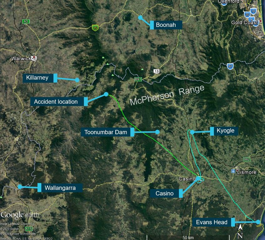
Safety summary
What happened
On the afternoon of 12 January 2020, the pilot of an amateur-built Wittman Tailwind aircraft,
registered VH-TWQ (TWQ), departed Evans Head Airport, New South Wales, with one passenger
on board. The pilot was conducting a private flight under the visual flight rules from Evans Head,
to Boonah, Queensland.
The pilot flew in a north-north-westerly direction towards Boonah via the Richmond River valley. At
1353, the pilot commenced a 180° turn overhead the township of Kyogle and diverted, due to the
weather, south back down the valley to Casino Aerodrome, landing at 1406.
At 1454, the pilot took off from Casino and flew in a west-north-westerly direction. At 1512 TWQ
commenced a series of rapid descents and climbs followed by a descending left turn. The turn
and descent continued until TWQ collided with terrain. The pilot and passenger were fatally
injured, and the aircraft was destroyed.

What the ATSB found
The ATSB found that the pilot departed an interim landing site for Boonah under the visual flight
rules with a high risk of encountering forecast cloud. En route to Boonah, the aircraft entered an
area of reduced visibility and the pilot likely became spatially disorientated resulting in a loss of
control and collision with terrain.

Safety message
Weather-related accidents remain one of the most significant causes of fatal accidents in
general aviation and continues to be a focus of the ATSB’s SafetyWatch initiative. SafetyWatch
highlights the broad safety concerns that come out of our investigation findings and from the
occurrence data reported to us by industry. One of the safety concerns relates to inflight
decision making, particularly involving pilots flying with reduced visual reference. SafetyWatch
provides information about each safety concern, and strategies to help manage risk areas,
along with links to safety resources. In relation to visual flight rules (VFR) pilots flying into areas
of reduced visibility, some key messages are:
• Pilots should avoid deteriorating weather by conducting thorough pre-flight planning. They
  should ensure they have alternate plans in case of an unexpected deterioration in the weather
  and make timely decisions to turn back, divert or hold in an area of good weather.
• VFR pilots should use a ‘personal minimums’ checklist to help control and manage flight risks
  through identifying risk factors that include marginal weather conditions and only fly in
  environments that do not exceed their capabilities.
• Pilot’s should consider reducing speed and/or altering the configuration of the aircraft to allow
  more time for decision making and maneuvering in areas of deteriorating or marginal weather
  conditions
• Pressing on into instrument meteorological conditions without a current instrument rating
  carries a significant risk of severe spatial disorientation due to powerful and misleading
  orientation sensations with reduced visual cues. Disorientation can affect any pilot, no matter
  what their level of experience.
• If VFR pilots find themselves in marginal weather and becoming disoriented or lost, they
  should seek whatever help is available. Air Traffic Services (ATS) may be able to provide
  assistance, especially if the aircraft is in ATS surveillance coverage. There have been a
  number of reported occurrences where this simple action has averted potential disaster.

                                                  ›i‹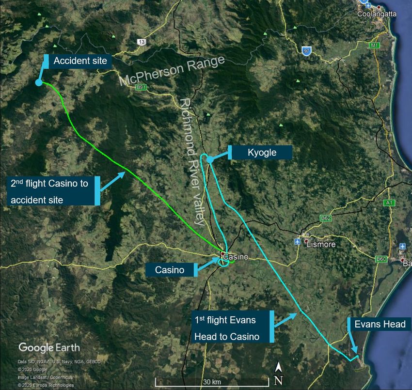
Contents
  Safety summary ........................................................................................................................i
  The occurrence ........................................................................................................................1
  Context ......................................................................................................................................3
    Pilot information                                                                                                                           3
              General information                                                                                                              3
              Medical information                                                                                                              3
       Aircraft information                                                                                                                    3
              Overview                                                                                                                         3
              Operating limitations                                                                                                            4
              Navigation / cockpit instruments                                                                                                 4
       Wreckage and accident site information                                                                                                  4
              Accident site                                                                                                                    4
              Wreckage examination                                                                                                             5
              Engine and propeller                                                                                                             5
              Flight control system                                                                                                            5
              Fuel                                                                                                                             5
              Weight and balance                                                                                                               5
              Emergency locator transmitter                                                                                                    6
       Operational Information                                                                                                                 6
       Meteorological information                                                                                                              7
              Bureau of Meteorology forecast                                                                                                   7
              Bureau of Meteorology observations and analysis                                                                                  8
              Lismore airport observations                                                                                                     8
              Casino aerodrome weather recordings                                                                                              8
              Witness observations of weather                                                                                                  9
              Pilot access to weather information                                                                                              9
       Recorded data                                                                                                                         10
              Overview                                                                                                                       10
       Additional information                                                                                                                11
              Visual Flight Rules                                                                                                            11
              Risks of flying in areas of reduced visual cues                                                                                12
              Spatial disorientation                                                                                                         13
              Related Occurrences                                                                                                            13
  Safety analysis ...................................................................................................................... 15
  Findings ................................................................................................................................. 17
     Contributing factors                                                                                                                    17
  General details ...................................................................................................................... 18
  Sources and submissions .................................................................................................. 19
  Australian Transport Safety Bureau .................................................................................. 21

                                                                  › ii ‹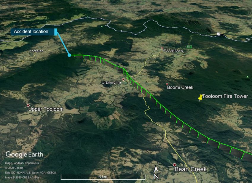
ATSB – AO-2020-004
The occurrence
On Friday, 10 January 2020 the pilot of an amateur-built Wittman Tailwind aircraft, registered
VH-TWQ (TWQ), departed Toowoomba, Queensland, and flew via Boonah, to Evans Head, New
South Wales. The purpose of the flight was to pick up a passenger at Boonah and then attend the
Great Eastern Fly-In (Fly-In) at Evans Head. The Fly-In was planned for the weekend of
11-12 January. However, due to poor weather, the event program was significantly disrupted.
On the morning of 12 January 2020, the pilot attended the Fly-In event briefing which included the
meteorology for the day. The event was cancelled at 0830 due to the cloud base at Evans Head
being approximately 1,000 ft above ground level (AGL) with a reduction to 600 ft AGL forecast
during the day. Due to the cancellation of the event the pilot elected to return to Toowoomba and
contacted relatives there for an update on the weather. They sent photos of the local conditions
and said the cloud at Toowoomba was not really low, there was no wind and there had been
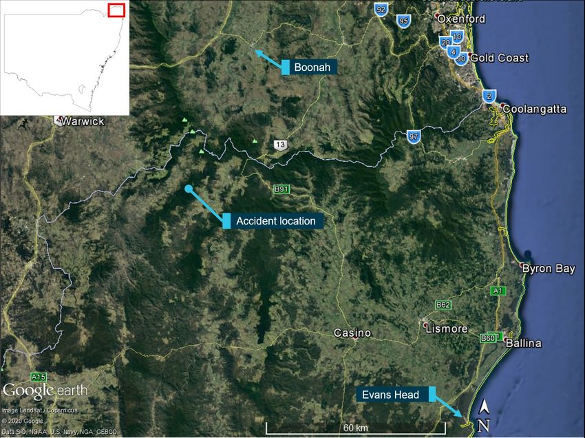
some rain. At 1336 Eastern Daylight-saving Time, 1 the pilot departed Evans Head Airport , with
one passenger on board. The pilot was conducting a private flight under the visual flight rules 2 to
Toowoomba via Boonah (Figure 1).
Figure 1 - Accident flight departure, destination and accident locations
Source: Google Earth, annotated by the ATSB
The pilot flew in a north-north-westerly direction towards Boonah via the Richmond River valley
(Figure 2). The aircraft reached a maximum altitude of 1,950 ft above mean sea level 3 just prior to
1
Eastern Daylight-saving Time (EDT): Coordinated Universal Time (UTC) +11 hours.
2
Visual flight rules (VFR): a set of regulations that permit a pilot to operate an aircraft only in weather conditions
generally clear enough to allow the pilot to see where the aircraft is going.
3
Above mean sea level (AMSL): All altitudes and heights will be referenced to AMSL unless otherwise stated.
›1 ‹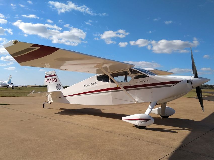
ATSB – AO-2020-004

reaching Kyogle. At 1353, the pilot commenced a 180° turn overhead the township of Kyogle and
diverted, likely due to low cloud on their intended flight path. At 1357 a family member contacted
the passenger as they had seen the turnaround overhead Kyogle on OzRunways. 4 The
passenger replied to say they were ‘going home due low cloud’. The pilot flew south back down
the valley to Casino Aerodrome, landing at 1406.
During the time on the ground at Casino, the pilot contacted a friend in the area and left a voice
message. The message stated they could not get past Kyogle due to the weather, so they had
landed at Casino. (refer to the section titled Meteorological information below.)
Figure 2 - Flight tracks for VH-TWQ on 12 January 2020

Source: Flightradar24 and Google Earth, annotated by the ATSB

At 1454, the pilot took off from Casino and flew in a west-north-westerly direction. At 1510 TWQ
commenced a series of rapid descents and climbs, between 3,100 and 4,000 ft, followed by a left
descending turn. Shortly afterwards TWQ collided with terrain. The pilot and passenger were
fatally injured, and the aircraft was destroyed. There were no witnesses to the accident.

4
    The OzRunways application is an electronic flight bag. An electronic flight bag is a portable information system for flight
    deck crew members which allows storing, updating, delivering, displaying and/or computing digital data to support flight
    operations or duties. It provides the option for live flight tracking by transmitting the device’s position and altitude
                                                                ›2 ‹
ATSB – AO-2020-004
Context
Pilot information
General information
The pilot held a Private Pilot Licence (Aeroplane) issued in July 1982 and was qualified to fly by
day under the visual flight rules. The pilot also held a single-engine aeroplane class rating. The
pilot last conducted a single-engine aeroplane flight review in June 2018 that was valid until
June 2020. The pilot had about 1,200 hours flying experience recorded in the pilot’s logbook with
a total of about 140 hours on the Wittman Tailwind. In the 90 days prior to the accident, the pilot
had flown 12.4 hours total, of which 11.2 hours were in TWQ.
The pilot’s logbook showed a total of 8.4 hours instrument flying experience. Of these, 5 hours
were accumulated between 1982 and 1983. The remaining 3.4 hours were accumulated from
1986 to 2015. The pilot did not hold an instrument rating.
Medical information
The pilot held a Class 2 aviation medical certificate that was valid until October 2021 with two
restrictions noted. One restriction required distance vision correction be worn and the other
required reading correction to be available during flight.
The pilot was reported to be in good health and not taking any medications at the time of the
accident.
Due to the pilot being away from home for the days preceding the accident, a detailed 72-hour
history could not be obtained. From the limited information available there were no fatigue-related
concerns identified.
A limited post-mortem examination and toxicological screening was performed. There was nothing
found to support incapacitation.
Aircraft information
Overview
VH-TWQ (TWQ) was a Wittman Tailwind, an amateur-built aircraft in the experimental category.
TWQ had a two seat, side-by-side seating arrangement. The structure was a combination of
tubular steel frames and fabric covering on the fuselage. Wooden wing ribs had a bonded
plywood skin covering. The flight controls consisted of push-pull type control tubes. All flight
controls and flaps were fabric covered. The Wittman had a fixed undercarriage in a taildragger
configuration.
TWQ was fitted with a Lycoming XIO-320 5 four cylinder, horizontally opposed piston engine and
was fitted with a ground adjustable Whirlwind two-bladed composite propeller.
Entries in the logbook indicated that the owner-pilot commenced construction of the aircraft as an
amateur builder in January 2006. The aircraft was completed in August 2018. A CASA authorised
person issued a special certificate of airworthiness in the experimental category on
25 December 2018.
On 28 June 2019, the pilot issued a maintenance release that was valid for 12 months. This
allowed the aircraft to be operated privately under the day visual flight rules. The aircraft flew for
5
The X designation is added to the engine model when used in the amateur built or experimental aircraft category.
›3 ‹ATSB – AO-2020-004
33.3 hours between 28 June 2019 and the day of the accident. No defects or unserviceable
equipment endorsements were recorded on the maintenance release.
The last entry in the aircraft’s maintenance records was the change, by the pilot, of the engine oil
and filter in October 2019. The pilot changed the engine oil filter in accordance with the
maintenance schedule.
Operating limitations
Aircraft operating limitations were contained within the flight manual for the aircraft and relevant
limitations are detailed in Table 1 and Table 2.
Table 1 – Airspeed limitations
Speed Knots indicated airspeed Remarks
(KIAS)
Vne – Never exceed 174 Do not exceed this speed in any
operation
Vno – Max structural cruising 155 Do not exceed this speed except
in smooth air, then only with
caution
Va – Manoeuvring 155 Do not make full or abrupt control
movement above this speed,
because under certain conditions
the aircraft may be overstressed.
Table 2 - Stall speeds
Configuration Power off (KIAS) Power on (KIAS)
Clean 52 49
Flaps Land 47 40
Navigation / cockpit instruments
The aircraft was fitted with a Garmin G3X (G3X) flight display, capable of displaying the engine
monitoring instruments, primary flight instruments and navigation information.
The pilot was reported to navigate primarily by using paper maps, using the main Garmin screen
to display attitude and heading information as well as engine parameters. The pilot had an iPad
mounted beside the G3X unit running the OzRunways application. It was reported that the pilot’s
use of OzRunways navigation and flight planning features was limited to using the direct to
function which plotted a track from the aircraft’s current location to a desired destination. The pilot
was also reported to use the weather radar overlay function on OzRunways. This overlay
displayed rain when detected by radar but did not display the presence of clouds.
Wreckage and accident site information
Accident site
The accident site was located in dense rainforest, about 72 km west-north-west of Casino, within
the Tooloom National Park (Figure 2). The New South Wales Police Rescue and Bomb Disposal
Unit assisted ATSB investigators to access the site on foot.
The accident site was on the eastern side of a ridgeline at an elevation of 3,170 ft. The highest
ground in the immediate area of the accident site was approximately 3,200 ft.
›4 ‹ATSB – AO-2020-004
Wreckage examination
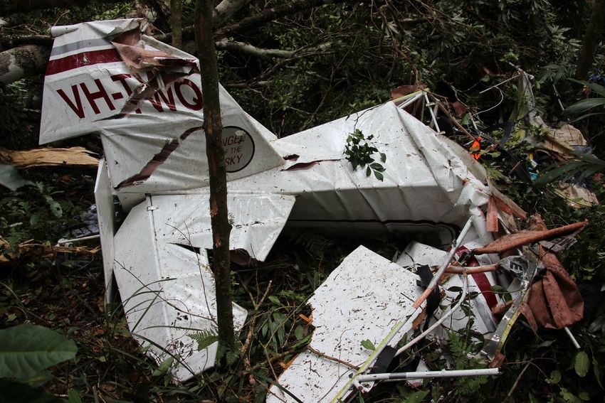
The aircraft’s structure was substantially disrupted (Figure 3). The wreckage trail was about 120 m
long on a bearing of approximately 270°. All major aircraft components were located at the
accident site. ATSB investigators did not identify any signs of pre-existing airframe damage. Due
to the disruption of the airframe, the aircraft’s attitude when it entered the tree canopy could not be
determined. There was no evidence of fire. Site and wreckage examination did not identify any
defects or anomalies that might have contributed to the accident.
Figure 3 - VH-TWQ’s empennage at the accident site
Source: ATSB
Engine and propeller
On-site examination of the engine and propeller did not identify any defects that could have
contributed to the accident. Damage noted to the propeller, during this examination, were
consistent with the engine producing significant power at the time of the accident.
Flight control system
All primary and secondary flight controls were located on-site. An examination of the flight control
systems did not identify any faults that could have contributed to the accident.
Fuel
The fuel tank was located toward the end of the wreckage trail. It was torn from the fuselage and
had ruptured. Rain had entered the tank post-accident, therefore the fuel that remained in the tank
was not tested.
Weight and balance
The on-site examination found a small amount of lightweight cargo. It was reported that the
occupants took minimal cargo with them when they departed for the weekend. Weight and
balance was calculated using full fuel and maximum baggage on departure out of Toowoomba
and was calculated to be within limits. The aircraft did not refuel again after departing
Toowoomba. Weight and balance was also calculated for the expected fuel remaining at the time
of the accident and was also within limits.
›5 ‹ATSB – AO-2020-004
Emergency locator transmitter
The aircraft was not fitted with an ELT, nor was it required to be. An Emergency Position
Indicating Radio Beacon was located in the wreckage and had not been activated. This unit was
tested on-site and functioned as required.
Operational Information
The flight from Evans Head to Boonah required the pilot to cross the McPherson Range
(Figure 4). The McPherson Range is a spur of the Great Dividing Range, heading in an easterly
direction from near Wallangarra, Queensland, to the coast. It also forms part of the border
between New South Wales and Queensland.
Figure 4 - Accident site and McPherson Range
Source: Google Earth and Flightradar24, annotated by the ATSB
Terrain across the range varies in altitude with several areas above 3,000 ft and some peaks
above 4,000 ft.
The initial flight from Evans Head to Casino, indicated that the aircraft was attempting to cross the
ranges via a route known as the ‘border loop’. The border loop is a route commonly used by VFR
pilots to transit the range. Tracking is north up the Richmond River valley, past the town of Kyogle,
then over the ranges where the railway cuts through the high ground.
Another common route over the ranges is to fly via the Toonumbar Dam, then Killarney to
Warwick, which is similar to the track of the second flight. Another pilot who attended the Fly-In
›6 ‹ATSB – AO-2020-004
reported that when attempting to fly over the ranges they use a minimum of 4,000 ft, and normally
fly over the range at about 5,000 ft.
Meteorological information
Bureau of Meteorology forecast
The planned flight from Evans Head to Boonah traversed two Graphical Area Forecast (GAF) 6
areas. The accident site was located on the border of the GAF NSW East (NSW-E) and the GAF
QLD South (QLD-S).
Forecast weather conditions in the GAF for NSW-E, valid from 1000 to 1600 on 12 January 2020,
that potentially affected the flight included:
• Average conditions of greater than 10 km visibility with areas of broken 7 stratocumulus clouds
between 3,000 and 6,000 ft
• Widespread smoke reducing visibility to 8,000 m
• Isolated showers of rain reducing visibility to 4,000 m with associated cloud including broken
stratus 1,000 to 2,000 ft and broken cumulus, stratocumulus 2,000 to 8,000 ft
• Isolated thunderstorms and rain reducing visibility to 2,000 m with associated cloud including
isolated cumulonimbus 6,000 to above 10,000 ft, broken stratus 500 to 2,000 ft and broken
stratocumulus 2,000 to 6,000 ft
• Isolated smoke over land reducing visibility to 1,000 m
• Moderate turbulence is implied in cumulous, stratocumulus and altocumulus cloud. Severe
turbulence is implied in thunderstorms, cumulonimbus and towering cumulus
The GAF for QLD-S was valid from 0900 to 1500. Forecast conditions that potentially affected the
flight included:
• Average conditions of greater than 10 km visibility with areas of scattered stratus 1,500 to
3,000 ft, scattered cumulus and stratocumulus 2,500 to 7,000 ft, and further cloud layers above
8,000 ft
• Isolated dust and smoke reducing visibility to 7,000 m and 5,000 m respectively
• Scattered rain reducing visibility to 5,000 m with associated broken stratus 1,200 to 4,000 ft,
broken stratocumulus 5,000 to 8,000 ft and broken altocumulus and altostratus 8,000 to above
10,000 ft
• Scattered showers of rain reducing visibility to 3,000 m with associated occasional towering
cumulus 5,000 to above 10,000 ft and broken stratus 1,200 to 3,000 ft
• Isolated thunderstorms and rain reducing visibility to 2,000 m with associated isolated
cumulonimbus 4,000 to above 10,000 ft, broken stratus 1,500 to 4,000 ft and broken
stratocumulus 4,000 to 6,000 ft
• Moderate turbulence is implied in cumulous, stratocumulus and altocumulus cloud. Severe
turbulence is implied in thunderstorms, cumulonimbus and towering cumulus
Neither of the GAFs were corrected and no SIGMETs or AIRMETs affecting the QLD-S area were
issued during the validity period. An AIRMET was issued for the NSW-E GAF region, however this
was for an area to the west of the flight path and did not affect the conduct of this flight.
6
Graphical Area Forecast (GAF) provides information on weather, cloud, visibility, icing, turbulence and freezing level in
a graphical layout with supporting text. These are produced for 10 areas across Australia, broadly State-based.
7
Broken cloud: used to describe an amount of cloud covering the sky of between five and seven oktas (eighths).
›7 ‹ATSB – AO-2020-004
The Bureau of Meteorology (BoM) Grid Point Wind and Temperature forecast valid at the time of
the flight, forecast the wind to be 20 kt from 160° at 2,000 ft and 19 kt from 130° at 5,000 ft.
The BoM also provided an aerodrome forecast (TAF) 8 for Ballina and Lismore. Lismore
Aerodrome was the closest aerodrome to the flight path with a TAF available. TWQ flew within
9.7 km of Lismore aerodrome on the flight from Evans Head to Casino. Lismore is located 20 km
east north east of Casino with an elevation of 35 ft. The amended Lismore TAF, issued at 1145 on
12 January 2020, was valid from 1300 on the day of the accident. The TAF forecast 14 kt winds
from 160°, visibility greater than 10 km and light showers of rain. Cloud was forecast to be
scattered with a base of 2,000 ft above the aerodrome and broken with a base 3,000 ft above the
aerodrome. The forecast indicated that between 1300 and 1700 there would be temporary
periods, greater than 30 minutes but less than 60 minutes in duration, of deteriorating weather
conditions. These conditions included visibility reducing to 4,000 m, showers of rain and broken
cloud with a base of 1,000 ft above the aerodrome.
Great Eastern Fly-In event meteorology
On the morning of 12 January 2020, the pilot of TWQ attended the Fly-In pilot’s briefing which
included the meteorology for the day. The briefing, delivered by event staff, included weather
information based on forecasts available from the BoM for Evans Head, the surrounding airfields
and the GAF NSW-E. The display was cancelled at 0830 during the briefing due to the cloud base
at Evans Head being approximately 1,000 ft above ground level (AGL) with a reduction to 600 ft
AGL forecast during the day.
Bureau of Meteorology observations and analysis
The BoM reported that there were no observations of the actual conditions at the location of the
accident. The BoM commented that the winds south of the McPherson Range, below 5,000 ft,
would have been south-west to south-easterly. The generally southerly wind flow, heading
towards the range, would be consistent with orographic cloud 9 formation. The BoM noted that the
forecast broken cloud at 3,000 ft was likely to be a reasonable representation of the conditions.
The BoM also stated that the summits of Wilsons Peak at 4,030 ft and Mount Barney 4,430 ft are
higher than the bases of the cloud forecast in this area. No thunderstorm activity was detected
near the flight path from Casino.
Lismore airport observations
Half hourly observations 10 were recorded at Lismore Airport on the day of the accident. At 1500,
the wind was from 170° at an average speed of 11.1 kt, with a gust of 15.9 kt recorded. The
temperature was 23.2 °C and the mean seal level pressure was 1014.4 hectopascals (hPa).
Cloud was overcast with a base of 3,300 ft.
Casino aerodrome weather recordings
The Casino Automatic Weather Station (AWS) recorded several weather parameters on the day
of the accident. At 1500, the wind at Casino Aerodrome was from 170° at an average speed of
6 kt and the temperature was 23.6 °C. No cloud data is available for Casino AWS, as no
ceilometer is installed at this location.
8
Aerodrome Forecast (TAF): a statement of meteorological conditions expected for a specific period of time in the
airspace within a radius of 5 NM (9 km) of the aerodrome reference point. The heights referenced in TAFs are heights
above the aerodrome reference point (ground).
9
Orographic cloud forms when airflow encounters a mountain or hill and is forced to rise. If the flow (air) is sufficiently
humid, clouds form on the windward side of mountains and are called orographic clouds
10
Observations for Lismore Airport, including for cloud, are automated using information from sensors only.
›8 ‹ATSB – AO-2020-004
Witness observations of weather
Local residents
Residents in the vicinity of the accident location confirmed that the top of the ridgeline, where the
accident site was located, was in cloud on the afternoon of the accident. Several of the witnesses
commented they could see about three quarters of the way up the ridgeline, which was calculated
to be approximately 2,800 ft. These residents commented that it was an overcast day and it had
been raining on and off throughout the day.
Tooloom fire tower weather observations
The Forestry Corporation of New South Wales has several observation towers positioned in the
region of the flight. The Tooloom tower is located closest to the flight path from Casino, at an
elevation of 2,619 ft (Figure 5).
An observer was positioned in the tower on 12 January from 0900 to 1500 and recorded weather
conditions on the hour. Throughout the day, visibility remained at 0 km, with the cloud recorded as
8 oktas. In addition, the relative humidity was recorded at 98 per cent or above throughout the
day. The wind was from the south-south-east around 9 kt with an average gust of 19 kt.
Figure 5 – Tooloom fire tower location and proximity to flight track
Source: Google Earth and Flightradar24, annotated by the ATSB
Flight track proximity to Tooloom Fire Tower
At 1509, TWQ, at its closest, passed 4.23 km to the west south west of the Tooloom Fire Tower
(Figure 5). The aircraft was tracking from the south-east to the north-west. At 1509 the aircraft was
at 3,575 ft, with a ground speed of 141 kt and tracking 332°. Tooloom Fire Tower has an elevation
of 2,619 ft, and was in cloud at 1500, as it had been since 0900.
Pilot access to weather information
On the morning of the accident, the pilot attended the Fly-In event briefing which included weather
for the event and the area. There was no log recorded indicating that the pilot accessed the
›9 ‹ATSB – AO-2020-004
weather information through the National Aeronautical Information Processing System (NAIPS) on
the day of the accident. However, it is possible that the pilot obtained additional weather
information from other sources.
Recorded data
Overview
The aircraft was fitted with a Mode S transponder that broadcast ADS-B 11 data which included the
position and altitude of the aircraft. The data was received by Flightradar24 and provided to the
ATSB. Also on-board was a mobile device with the OzRunways electronic flight bag (EFB)
application installed. The application had an option enabled for live flight tracking by transmitting
the device’s position and altitude. OzRunways information was also obtained by the ATSB. This
data had a sampling rate of every 5 seconds.
The ATSB compared the data from both sources and they were found to be consistent. The flight
data from OzRunways was plotted for the accident flight along with the terrain elevation.
(Figure 6).
Figure 6 - OzRunways data and terrain elevations for the final flight of TWQ
Figure 5 shows the aircraft’s flight data from OzRunways. Groundspeed is annotated in red, altitude in light blue and track in black. The
altitude of Tooloom fire tower is also marked in blue. This line starts from the time where TWQ was abeam the fire tower. Terrain directly
underneath the flight path is marked in green.
Source: OzRunways, US National Aeronautics and Space Administration Shuttle Radar Topography Mission data and ATSB
The first climb on the graph is part of the departure from Casino aerodrome. On a track generally
to the north-west. The aircraft reached 3,000 ft and then descended to 2,200 ft.
11
ADS-B: Automatic Dependent Surveillance–Broadcast is a surveillance technology in which an aircraft determines its
position via satellite navigation and periodically broadcasts it, enabling it to be tracked.
› 10 ‹ATSB – AO-2020-004
The climb that commenced at approximately 1502 corresponded with the first range of high
ground en route. A groundspeed of about 145 kt was maintained during this climb. The climb
commenced at 2,200 ft and reached a peak of 4,100 ft.
The following descent from 4,100 ft to 3,100 ft, corresponded to a ground speed increase from
145 kt to 173 kt and a rate of descent of about 600 feet per minute. The altitude of TWQ at the
bottom of this descent was above the altitude of Tooloom Fire Tower (Figure 6).
Over the last 4 minutes of the flight, the aircraft’s recorded groundspeed, rate of climb/descent and
altitude oscillated significantly over short periods with the aircraft’s:
• ground speed varying rapidly between 109 and 175 kt,
• rate of climb and descent being between maximum values of +2,400 ft per minute and -
2,400 ft per minute,
• altitude oscillating between 4,000 and 3,100 ft.
At approximately 1512 the final descent and turn towards the high ground commenced. The
descent commenced from 4,000 feet with the aircraft travelling at 133 kt groundspeed and
tracking 316°.
The last data point was recorded at 1512:49. The aircraft was passing 3,100 ft with an 1,800 feet
per minute rate of descent. It was travelling at 172 kt groundspeed and tracking 276°.
Of note, during the last few minutes of flight, prior to the collision with terrain, TWQ maintained
more than 1,000 ft clearance with the ground and in most places more than 2,000 ft above the
ground.
G3X flight display
The G3X unit can log flight and engine data on a removable SD card, or additionally to an internal
Flight Log. The G3X unit was badly damaged in the accident sequence. The SD card and a
number of circuit boards from the G3X unit were recovered from the accident site. The SD card
was found in the read only mode and therefore did not contain any data from the accident flight.
While some flight data was able to be recovered from the internal memory, the last recovered
flight data was from 30 December 2019.
Air Traffic Control
TWQ was operating outside controlled airspace at the time of the accident. The Brisbane Centre
audio recording was obtained from Airservices for the New England area, which covered the
accident flight path. There were no radio calls recorded from TWQ, however, they were not
required to make any routine radio calls on this frequency.
Additional information
Visual Flight Rules
The CASA Visual Flight Rules Guide outlined that flight under the visual flight rules (VFR) can only
be conducted in Visual Meteorological Conditions (VMC). 12 Additionally, when operating at or
below 2,000 ft above the ground or water, the pilot must be able to navigate by visual reference to
the ground or water.
12
Visual Meteorological Conditions (VMC): a meteorological condition in which visual flight rules (VFR) flight is permitted
– that is, conditions in which pilots have sufficient visibility to fly the aircraft while maintaining visual separation from
terrain and other aircraft.
› 11 ‹ATSB – AO-2020-004
The flight, and the location of the accident, were in (non-controlled) Class G airspace. The
following conditions were stipulated for flight under the VFR in Class G airspace when below
10,000 ft and above 3,000 ft or 1,000 ft above ground level (whichever is higher):
• a flight visibility of 5,000 m
• a minimum vertical distance of 1,000 ft and horizontal distance of 1,500 m from cloud.
In the case of aeroplane operations in Class G at or below 3,000 ft or 1,000 ft above ground level
(whichever is higher), the following minimum conditions were stipulated:
• a flight visibility of 5,000 m
• that the aeroplane shall be maintained clear of cloud and in sight of the ground or water
In addition to minimum visibility and distance from cloud, a pilot is also required to maintain a
minimum height above the ground. CAR 157 details that a pilot in command must not fly the
aircraft over:
• any city, town, or populous area at a height lower than 1,000 ft; or
• any other area at a height lower than 500 ft.
This does not apply if through stress of weather or any other unavoidable cause it is essential that
a lower height be maintained.
Risks of flying in areas of reduced visual cues
The safety risks of VFR pilots flying from VMC conditions into instrument meteorological
conditions (IMC) 13 are well documented. This has been the focus of numerous ATSB reports and
publications, as VFR pilots flying into IMC represents a significant cause of aircraft accidents and
fatalities. In 2013, the ATSB Avoidable Accidents series was re-published. Of these publications,
the booklet titled Accidents involving pilots in Instrument Meteorological Conditions outlined that:
In the 5 years 2006–2010, there were 72 occurrences of visual flight rules (VFR) pilots flying in
instrument meteorological conditions (IMC) reported to the ATSB…About one in ten VFR into IMC
events result in a fatal outcome.
In another occurrence investigation, 14 the ATSB has found that the ‘continuation of flight towards
an area of low cloud and rain was likely influenced by the inherent challenges of assessing low
visibility conditions, particularly without instrument flying proficiency.’ This finding was based on
the following references.
The United States National Transportation Safety Board (NTSB) (2005) found that ‘reduced-
visibility weather represents a particularly high risk to [general aviation] operations’ and that
‘weather may…test the limits of pilot knowledge, training, and skill to the point that underlying
issues are identified.’ The NTSB study also outlined that historically, about two-thirds of all general
aviation (GA) accidents that occur in IMC are fatal, a rate much higher than the overall fatality rate
for GA accidents.
Wiegmann and Goh (2000) explained that pilots may make errors in assessing the deteriorating
weather conditions and decide to continue to VFR flight into the adverse weather. The previously
mentioned NTSB report (2005) added that in these cases, pilots who might appear to intentionally
engage in risky behaviour may actually be making choices that they mistakenly believe to be safe
by underestimating the risks associated or overestimating their ability to handle the risks.
13
Instrument meteorological conditions (IMC): weather conditions that require pilots to fly primarily by reference to
instruments, and therefore under Instrument Flight Rules (IFR), rather than by outside visual reference. Typically, this
means flying in cloud or limited visibility.
14
AO-2016-006 Loss of control and collision with water involving Piper Aircraft Corp PA-28-235, VH-PXD. A copy of this
report is available from www.atsb.gov.au
› 12 ‹ATSB – AO-2020-004
Wiggins and O’Hare (1995) further explained how errors in assessment can take place,
acknowledging that weather-related decision making can be highly complex and therefore more
prone to errors:
Because of the variable nature of operations in the aviation environment, weather-related decision
making is often considered a skill that cannot be prescribed during training. Rather it is expected to
develop gradually through practical experience. However, in developing this type of experience,
relatively inexperienced pilots may be exposed to hazardous situations with which they are
ill-equipped to cope.
ATSB Aviation Research and Analysis Report B20070063, An overview of spatial disorientation
as a factor in aviation accidents and incidents, stated that pilots should not attempt to fly into
instrument meteorological conditions under the VFR. Pilots should develop a plan prior to take-off
on what to do if the weather en route is different from that expected or deteriorates. This plan
should consider a requirement to divert or turn back prior to entering instrument meteorological
conditions. However, this depends on a pilot correctly assessing the weather conditions. The
NTSB (2005) noted that targeted weather-related training programs have had some success in
teaching pilots to recognise and respond to deteriorating weather conditions.
A cue-based training system called Weatherwise, was made available to pilots by the Civil
Aviation Safety Authority (CASA). Additionally, CASA produced a Weather to Fly education
program which focuses on topics such as the importance of pre-flight preparation, making
decisions early, and talking to ATC.
One of the ATSB’s SafetyWatch priorities concerns in-flight decision making in relation to VFR
flight in environments with reduced visual references. One of the key messages is for pilots to
avoid deteriorating weather by conducting thorough pre-flight planning and to have alternate plans
in case of an unexpected deterioration in the weather and making timely decisions to turn back or
divert.
Spatial disorientation
Spatial disorientation is a type of loss of situation awareness, and is different to geographical
disorientation, or incorrectly perceiving the aircraft’s distance or bearing from a fixed location.
Spatial disorientation occurs when pilots do not correctly sense their aircraft’s attitude, airspeed or
altitude in relation to the earth’s surface. In terms of an aircraft’s attitude, spatial disorientation is
often described simply as the inability to determine ‘which way is up’, although the effects can
often be more subtle than implied by that description.
Spatial disorientation occurs when the brain receives conflicting or ambiguous information from
the sensory systems. It is likely to happen in conditions in which visual cues are poor or absent,
such as in adverse weather or at night. 15 Spatial disorientation presents a danger to pilots, as the
resulting confusion can often lead to incorrect control inputs and resultant loss of aircraft control.
Research on spatial disorientation indicates that, for pilots who are not instrument rated, loss of
control will likely occur between about 60 seconds (Benson, 1988 in Gibb, Gray and Scharff,
2010) and 178 seconds on average (Bryan, Stonecipher, & Aron, 1954) after the loss of visual
reference. These studies led to the FAA’s and CASA’s ‘178 seconds to live’ educational
campaigns. Gibb, Gray and Scharff (2010) also stated that ‘spatial disorientation accidents have
fatality rates of 90–91 percent, which indicates how compelling the misperceptions can be.’
Related Occurrences
There have been a number of accidents relating to VFR pilots flying into reduced visibility
conditions. Many of these occurrences have been summarised in the research reports previously
15
More information about spatial disorientation can be found in the ATSB aviation research and analysis report
B2007/0063, An overview of spatial disorientation as a factor in aviation accidents and incidents.
› 13 ‹ATSB – AO-2020-004
mentioned (B2005/0127 and AR-2011-050) as well as in ATSB accident reports (for example,
AO-2015-131 and AO-2016-006). Of particular interest are those occurrences where pilots have
avoided an accident outcome by seeking assistance from other aircraft or from ATC. Of note are
two occurrences that occurred on the same day in a similar location but with a very different
outcome. See below for details.
ATSB Investigation AO-2017-061
On 16 June 2017, a Cessna Aircraft Company C172M, registered VH-FYN, was being operated
on a private flight from Southport Mason Field, Queensland to Ballina Airport, New South Wales.
The purpose of the flight was to ferry the aircraft to Ballina for scheduled maintenance. Enroute,
near the town of Bangalow New South Wales, the aircraft entered an area of reduced visibility,
including low cloud, fog and drizzle. The aircraft diverted off the initial track and was last seen
disappearing into cloud heading inland. A short time later the aircraft collided with terrain and the
pilot was fatally injured.
ATSB occurrence 201702740
On 16 June 2017, the pilot of a light aircraft was flying under VFR from Taree, New South Wales,
to Southport, Queensland. While near Ballina, New South Wales the weather suddenly
deteriorated and the pilot attempted to turn back to land at Coffs Harbor, New South Wales.
However, the weather continued to close in, at which point the pilot reported to ATC that he was
now flying in instrument meteorological conditions (IMC). ATC observed a sporadic radar return in
the position described by the pilot and advised that the pilot gain altitude, which assisted with
radar identification. ATC then guided the aircraft to Evans Head, New South Wales where the
weather had cleared sufficiently for the aircraft to land safely.
› 14 ‹ATSB – AO-2020-004
Safety analysis
Introduction
While en route from Evans Head, New South Wales, to Boonah, Queensland, the pilot of
amateur-built Wittman Tailwind aircraft, registered VH-TWQ (TWQ), diverted to Casino, New
South Wales, due to low cloud on the McPherson range. The pilot then took off after
approximately fifty minutes on the ground and attempted to reach Boonah via a different route
across the range. During the flight TWQ entered an area of reduced visibility. Approximately
fifteen minutes after take-off TWQ commenced a series of rapid climbs and descents followed by
a descending left turn which continued until TWQ collided with terrain.
Site and wreckage examination did not identify any defects or anomalies that might have
contributed to the accident. Additionally, there was no evidence to support the pilot being
incapacitated. Therefore, this analysis will focus on the examination of the factors that led to a
visual flight rules (VFR) pilot entering an area of reduced visibility and losing control of the aircraft.
Decisions to depart Evans Head and Casino
After the Fly-In was called off due to the poor forecast weather the pilot and passenger elected to
fly home to Boonah and Toowoomba. The pilot had attended the Fly-In event briefing that morning
and was therefore aware of the local weather conditions and forecast. Neither the pilot’s nor the
passenger’s family could identify a time pressure for the aircraft to return to Boonah and
Toowoomba that day.
The relevant Graphical Area Forecasts did not preclude a departure under the VFR from Evans
Head via Boonah to Toowoomba. However, they indicated the possibility of encountering areas of
cloud, dust and rain in which visibility would reduce below that required for VFR flight. The inland
route to Boonah, required the aircraft fly across the McPherson Range. Several of the peaks along
this range are greater than 3,000 ft and a few are greater than 4,000 ft.
The generally south-south-easterly wind flow, heading towards the range, would have had the
effect of pushing the weather up against the McPherson Range and reducing the visibility. So,
while it was possible to depart under the VFR, the forecast conditions would have indicated that it
was likely there would have been cloud on the ranges and have necessitated planning for an
alternate route or diversion to avoid the area if the actual conditions reflected the forecast.
The pilot’s decision to depart the interim landing site can be interpreted as likely taking advantage
of acceptable conditions at Casino with the notion that the weather further inland may have
allowed for VFR flight over the ranges.
Once airborne, the pilot would have been in a position to assess the in-flight visibility and cloud
and rain in the intended direction of travel. However, as discussed in the United States National
Transportation Safety Board report (2005), it is possible that the continuation of flight towards the
area of low cloud was influenced by the inherent challenges of assessing low visibility conditions.
The ATSB was unable to determine the pilot’s understanding of the weather conditions ahead of
the aircraft prior to entering an area of low visibility conditions. However, the pilot had
demonstrated an awareness of the risk posed by the weather and the need to maintain visual
reference by diverting from the original track and turning back from the first attempt to cross the
Ranges.
Development of the accident
Flying into an area of reduced visibility
The majority of the flight from Casino was conducted between 2,000 and 4,000 ft. Approximately
30 km north west of Casino the aircraft began a climb over the first area of high ground. Terrain in
› 15 ‹ATSB – AO-2020-004
this area is approximately 1,800 ft high. At about 1506, the aircraft reached a maximum altitude of
4,100 ft then entered a 600 ft/min descent where the groundspeed rapidly increased from 145 kt
to 173 kt. It is likely that the pilot initiated the climb to clear terrain and then descended when the
cloud conditions became unsuitable. This climb took TWQ above the forecast and observed cloud
heights in the area, which indicated a cloud base of around 2,600 - 2,800 ft. The descent levelled
out at 3,100 ft, and the terrain underneath was about 1,430 ft, allowing the pilot to continue the
descent a further 1,670 ft and remain clear of the terrain, if the pilot was visual with terrain. It is
possible that the pilot entered an area of deteriorating visibility at this time leading to the rapid
descent and level off well above terrain.
From this point on, the pilot flew no lower than 3,100 ft, which was around the height of the some
of the ridge lines in the area. It is therefore possible that the pilot was aware of the spot heights of
terrain in the area and was attempting to stay above them.
At about 1508, in the vicinity of the Tooloom Fire Tower, the pilot commenced another climb. As
the fire tower was in cloud, it is likely that the pilot entered an area of cloud during this climb. Flight
data showed that the final turn and descent of TWQ was towards the high ground. The accident
site was located near the top of the ridgeline. Either side of this ridgeline were areas of low
ground, which the pilot could have manoeuvred towards if visual with terrain. The direction of turn
as well as the descent and acceleration towards the terrain indicate the pilot was not visual with
terrain at the time of the accident.
Spatial disorientation resulting from a loss of visual cues
Flight data from the last 4 minutes of the flight recorded the aircraft’s groundspeed speed varying
between 109 and 175 kt. The aircraft’s rate of climb and descent varied between +2,400 ft/min
and -2,400 ft/min. The aircraft’s altitude varied between 4,000 and 3,100 ft.
Of note, the speed recorded by the data is ground speed. Forecast winds for the area were up to
20 kt in the direction of travel of TWQ and could be considered all tail wind. If the actual winds
were as forecast, the aircraft was being operated above the published manoeuvring speed limit of
130 kt indicated airspeed KIAS and likely up to the maximum structural cruising speed at some
points.
The final data point showed the aircraft descending through 3,100 ft and travelling at 172 kt
groundspeed. The aircraft was descending at 1,800 ft/min and was tracking towards the high
ground.
The flight data from the last 4 minutes of flight was not consistent with normal operations of a
Wittman Tailwind. The abrupt speed and altitude reversals and the operation of the aircraft over
and near these speed limitations are indicative of a loss of control.
It is therefore likely that within 4 minutes of flying into conditions of reduced visibility, without
adequate visual reference to the horizon, the pilot of TWQ became spatially disorientated leading
to a loss of control and collision with terrain. It is possible that the pilot of TWQ was able to
maintain some control initially upon entering cloud due to the pilot’s previous instrument flying
experience. However, without recent experience and the training and qualification of an instrument
rating the pilot was unlikely to have been able to maintain control in cloud for an extended period
of time.
› 16 ‹ATSB – AO-2020-004
Findings
ATSB investigation report findings focus on safety factors (that is, events and conditions that increase risk).
Safety factors include ‘contributing factors’ and ‘other factors that increased risk’ (that is, factors that did not
meet the definition of a contributing factor for this occurrence but were still considered important to include
in the report for the purpose of increasing awareness and enhancing safety). In addition ‘other findings’
may be included to provide important information about topics other than safety factors.
These findings should not be read as apportioning blame or liability to any particular organisation or
individual.
From the evidence available, the following findings are made with respect to the loss of control
and collision with terrain involving Wittman Tailwind, VH-TWQ, which occurred in Tooloom
National Park, New South Wales, 12 January 2020.
Contributing factors
• The pilot departed an interim landing site for Boonah under the visual flight rules with a high
risk of encountering forecast cloud that reduced conditions below that required for visual flight.
• It is likely the pilot encountered conditions of reduced visual cues and became spatially
disorientated which led to a loss of control and collision with terrain.
› 17 ‹ATSB – AO-2020-004
General details
Occurrence details
Date and time: 12 January 2020 – 1512 EDT
Occurrence category: Accident
Primary occurrence type: VFR into IMC
Location: Tooloom National Park, New South Wales
Latitude: 28º 25.062' S Longitude: 152º 28.503' E
Aircraft details
Manufacturer and model: Amateur-built Wittman Tailwind
Registration: VH-TWQ
Serial number: 63-10100
Type of operation: Private
Departure: Casino Aerodrome, New South Wales
Destination: Boonah Aerodrome, Queensland
Persons on board: Crew – 1 Passengers – 1
Injuries: Crew – 1 (fatal) Passengers – 1 (fatal)
Aircraft damage: Destroyed
› 18 ‹ATSB – AO-2020-004
Sources and submissions
Sources of information
The sources of information during the investigation included the:
• Bureau of Meteorology
• Civil Aviation Safety Authority
• Airservices Australia
• A number of witnesses
• recorded data from Fligthradar24 and OzRunways
References
Australian Transport Safety Bureau, 2011, Avoidable Accidents No. 4 Accidents involving Visual
Flight Rules pilots in Instrument Meteorological Conditions, Aviation Research and Analysis
publication AR-2011-050.
Australian Transport Safety Bureau, 2017, Loss of control and collision with water involving Piper
Aircraft Corporation, PA-28-235, VH-PXD, AO-2016-006.
Benson, AJ, 1999a, “Spatial disorientation – general aspects”, in J Ernsting, AN Nicholson & DJ
Rainford (Eds.), Aviation Medicine (3rd ed.), Oxford, England, Butterworth Heinemann, pp. 419-
436.
Gibb, R, Gray, R and Scharff, L, 2010, Aviation Visual Perception: Research, Misperceptions and
Mishaps, Ashgate Publishing Limited, Surrey, United Kingdom.
Newman, DG, 2007, An overview of spatial disorientation as a factor in aviation accidents and
incidents, Australian Transport Safety Bureau, Aviation Research and Analysis Report
B2007/0063.
National Transportation Safety Board 2005, Risk Factors Associated with Weather-Related
General Aviation Accidents, National Transportation Safety Board Safety Study NTSB/SS-05/01,
Washington DC, United States.
Wiegmann, D and Goh, J, 2000, Visual Flight Rules (VFR) Flight into Adverse Weather: An
Empirical Investigation of Factors Affecting Pilot Decision Making, Federal Aviation Administration
research DTFA 00-G-010, Illinois, United States.
Wiggins, M and O’Hare, D, 1995, “Expertise in Aeronautical Weather-Related Decision Making: A
Cross-Sectional Analysis of General Aviation Pilots”, Journal of Experimental Psychology: Applied
Vol. 1 No. 4, pp. 305-320.
Submissions
Under section 26 of the Transport Safety Investigation Act 2003, the ATSB may provide a draft
report, on a confidential basis, to any person whom the ATSB considers appropriate. That section
allows a person receiving a draft report to make submissions to the ATSB about the draft report.
A draft of this report was provided to the following directly involved parties:
• Family of the pilot
• Civil Aviation Safety Authority
• Fly-In Event Organiser
• Fly-In Chief Marshall
• Bureau of Meteorology
› 19 ‹ATSB – AO-2020-004
• Coroner’s representative
Submissions were received from:
• Bureau of Meteorology.
The submission was reviewed and, where considered appropriate, the text of the report was
amended accordingly.
› 20 ‹ATSB – AO-2020-004
Australian Transport Safety Bureau
About the ATSB
The ATSB is an independent Commonwealth Government statutory agency. It is governed by a
Commission and is entirely separate from transport regulators, policy makers and service providers.
The ATSB’s purpose is to improve the safety of, and public confidence in, aviation, rail and marine
transport through:
• independent investigation of transport accidents and other safety occurrences
• safety data recording, analysis and research
• fostering safety awareness, knowledge and action.
The ATSB is responsible for investigating accidents and other transport safety matters involving civil
aviation, marine and rail operations in Australia, as well as participating in overseas investigations
involving Australian-registered aircraft and ships. It prioritises investigations that have the potential to
deliver the greatest public benefit through improvements to transport safety.
The ATSB performs its functions in accordance with the provisions of the Transport Safety Investigation
Act 2003 and Regulations and, where applicable, international agreements.
Purpose of safety investigations
The objective of a safety investigation is to enhance transport safety. This is done through:
• identifying safety issues and facilitating safety action to address those issues
• providing information about occurrences and their associated safety factors to facilitate learning within
the transport industry.
It is not a function of the ATSB to apportion blame or provide a means for determining liability. At the same
time, an investigation report must include factual material of sufficient weight to support the analysis and
findings. At all times the ATSB endeavours to balance the use of material that could imply adverse
comment with the need to properly explain what happened, and why, in a fair and unbiased manner. The
ATSB does not investigate for the purpose of taking administrative, regulatory or criminal action.
Terminology
An explanation of terminology used in ATSB investigation reports is available on the ATSB website. This
includes terms such as occurrence, contributing factor, other factor that increased risk, and safety issue.
› 21 ‹You can also read