What does it mean to live Behind
←
→
Page content transcription
If your browser does not render page correctly, please read the page content below
What does
 it mean to
live Behind
  a Levee?
Ask Yourself This:
 Are My Home and Loved Ones
      Safe from Floods?
Most people know that levees are structures built near
rivers and lakes to reduce the risk of flooding. And
most property owners and residents in Fife know that
the Puyallup River is contained in a levee. But what
does it mean to live behind a levee? How much protec-
tion does a levee really provide? What do you need to
know to remain as safe as possible?

On the best of days, the Puyallup River has nourished
the Fife Valley, taking the glacial melt downstream to
the Sound, bringing salmon upstream to fishermen, and
providing a crucial outlet for the surrounding ground
waters.

                          2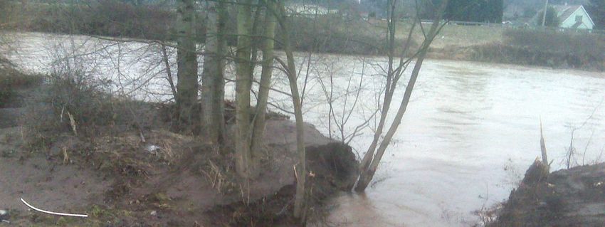
On  the worst of days, the Puyallup River, and those
who live near it, relies on a levee to hold back its flood
waters, keeping property dry and lives safe.

It’s during those worst of days, when Flood Watches
and Flood Warnings (see definitions next page) are sound-
ing, that you want to know that your home and your
loved ones are safe!

Living in Fife, you most likely live in a FEMA-declared
flood plain, and you definitely live behind a levee.

This booklet was created to provide the residents of Fife
with history and current information on the Puyallup
River Levee, with the intent to help answer your ques-
tions and encourage you to act now to better protect
yourself against future flood threats.

                            3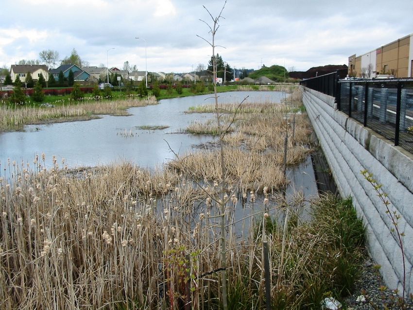
Definitions:
      Flood Watch: A flood watch is issued by the
      National Weather Service when flooding is
      possible within the designated watch area.
      Be alert!
      Flood Warning: A flood warning is issued
      when flooding has been reported or is
      imminent — take necessary precautions.

There are four essential facts about levees, explored in
depth in the following pages:
1. (page 6) Flooding will happen. All rivers, streams
   and lakes will flood eventually. Given enough time,
   any levee will eventually be overtopped or dam-
   aged by a flood that exceeds the levee’s capacity.
2. (page 8) No levee is flood-proof. Levees reduce the
   risk of flooding. But no levee system can eliminate
   all flood risk. A levee is generally designed to
   control a certain amount of floodwater.
3. (page 15) Risks associated with flooding vary. If you
   live behind a levee, you are responsible for knowing
   the threat you face from flooding. Don’t assume
   that someone else is watching out for you!
4. (page 18) Actions taken now will save lives and
   property. There are many steps you can take, from
   purchasing flood insurance, to developing an
   evacuation plan, to flood-proofing your home, to
   reporting any problems that you see. The better
   precautions you take, the better off you’ll be when
   the next flood occurs.

                           4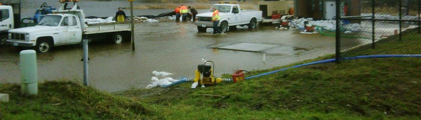
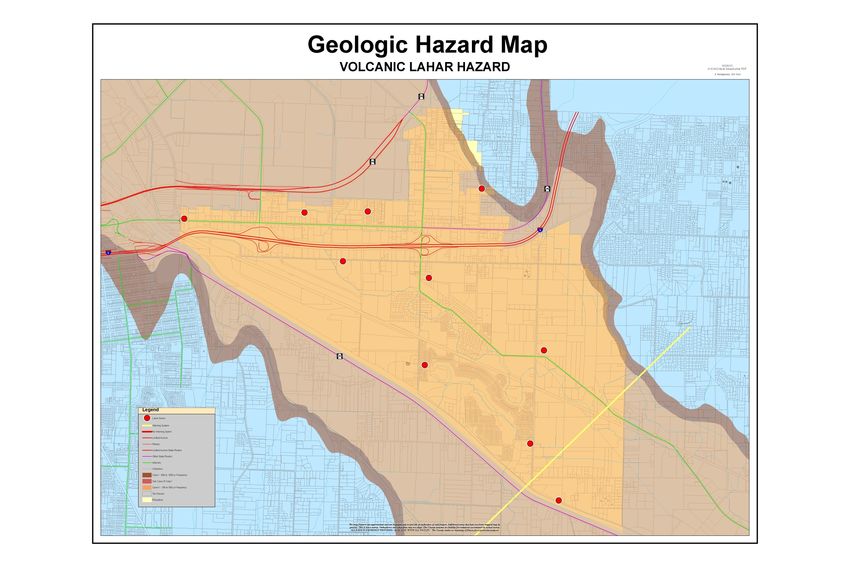
Without a levee in place, models show the expected flooding in
the event of a 100-year flood. This term and others are defined
in the following pages.

                              5
Fact Number

   1          Flooding will happen.
The   Puyallup River Levee construction began in the
early 1900s, with the lower reach completed following a
devastating flood in 1933. Although the levees were
built primarily to control inundation of agricultural
fields, the flood protection afforded by the levees
allowed human occupation and development of the
floodplain.

                                 Building the Puyallup
                                    Levee, circa 1930s

The second most significant flood on record occurred in
1996. Thanks to the Levee and Mud Mountain Dam,
constructed in 1948, widespread devastating flooding
did not occur. That event triggered efforts by multiple
agencies to develop a plan to address and lessen the risk
of future flood damages along the river; these efforts
continue to be put into practice today.

                           6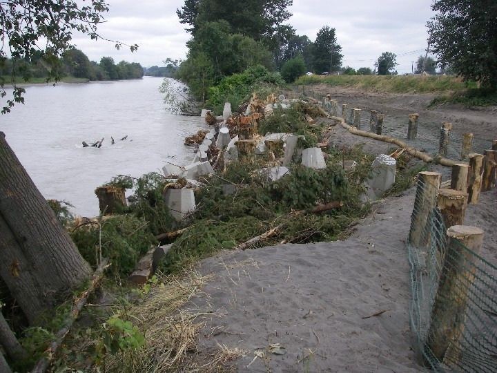
The 1933 flood occurred before floods were measured;
the 1996 flood qualified as a 100-year flood, as did the
events in 2006 and 2009, proving that the term doesn’t
equate to a 100-year time period.
How Flood Size is Defined
A common practice to describe the size of a flood is by
the “percent chance” that a flood will occur in a given
year. Experts estimate the percent chance by charting
the size of all known past floods at a location and
recording how often floods of a particular size occur.
Experts then estimate the probability
(or percent chance) that the floodwaters
will reach or exceed a certain level at
that location.
Smaller floods occur more often than
larger floods. Therefore, smaller floods
have a higher percent chance of
reaching or exceeding a particular 100-year flood?
                                             100-year levee?
floodwater level in any given year.
A flood that has a 1-in-10 chance of occurring in a single
year is also known as a 10%-annual-chance flood, or a 10
-year flood. A 1%-annual-chance flood (often referred to
as a 100-year flood) is likely to happen less often, but can
happen more than once in 100 years. A 1%-annual-
chance flood will have a higher floodwater level than a
10%-annual-chance flood. A “500-year flood” has only a
0.2 percent chance of occurring in a given year.
A levee designed to control a 1%-annual-chance flood,
often referred to as a 100-year levee, requires 3’ or more
of space, or “freeboard”, between the estimated top of
the waters in flood conditions and the top of the levee.

                             7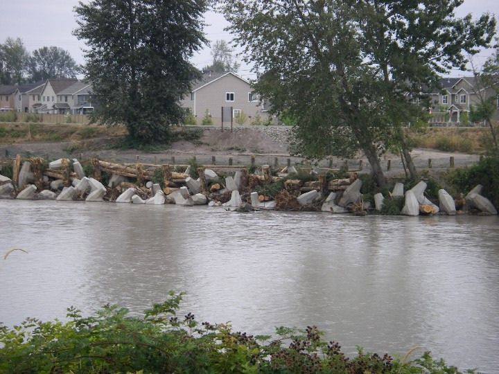
Fact Number

   2          No levee is flood-proof.
Levees reduce the risk of flooding, but no levee system
can eliminate all flood risk. Levees do not always
perform as intended, and can be damaged and
decertified. This has happened with the Puyallup River
Levee.
What Does Flood Size have to do with the Puyallup
River Levee?
Taking the historical flood information of the Puyallup
River into account, in 1987 the Army Corps of Engineers
(ACE) determined that the Levee could withstand a 100-
year flood event. FEMA (the Federal Emergency
Management Agency) then created and adopted flood
                  plain maps based on the protection of
                  the Levee. Over the years, sediment
                  has been deposited on the floor of the
                  river, to the point that, in 2004, the
                  ACE decertified the Puyallup Levee
                  based on lack of adequate freeboard.
                  Therefore, FEMA has drawn up new
   Freeboard?
                  flood maps that do NOT account for
 New flood maps?
                  the existence of a levee; these maps are
designed to estimate where and how much flooding
might occur in the event of a 100-year flood if the levee
should fail (see map page 5). Any location which falls
within this potential flood area is said to be in a flood-
plain. These new FEMA flood maps are scheduled to be
adopted by FEMA in September of 2010 and will subse-
quently affect flood insurance rates.

                            8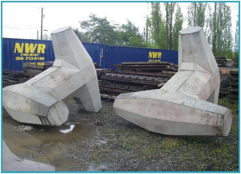
What Measures are Underway to Reduce the Risks
and/or the Impacts of Potential Flood Events?

Pierce County is conducting the Lower Puyallup River
Flood Protection Investigation study to address signifi-
cant flood and flood plain mapping related issues. The
Puyallup River Emergency Task Force, a coalition of
local jurisdictions and government agencies, is also
studying the issue and reporting to elected officials at
the local, state and federal levels. Additionally, the City
of Fife has entered into the Community Rating System,
sponsored by the National Flood Insurance Program.
Further information, as well as some of the early find-
ings of these studies, is detailed on the following pages.
What is the State of the Puyallup River Levee?
While the Levee no longer meets the certification
requirements of a 100-year-flood event, it remains in
good general condition. There is only one area of visible
erosion on the Fife side, and that was reinforced last
summer (see page 14). It is armored with concrete siding,
which does have some visible cracking; while this can
lead to “sand boils,” or seepage (see diagram below),
which could further undermine the stability of the levee,
at present, the probability of failure due to seepage is
considered low. The greatest threat is overtopping.

                            9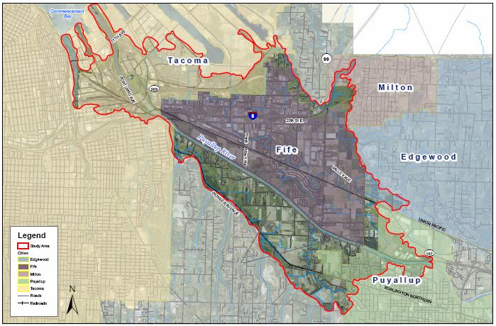
Management Measures

Identifying     viable means of mitigating* flood-related
risks for residents is a primary goal of jurisdictions and
agencies alike. After evaluating the condition of the
Levee, alternatives most feasible to the Fife side of the
                      Levee include setting the existing
    * Mitigating:     Levee back, improving or construct-
   Any sustained
                      ing new sections of the Levee, and
   action taken to
                      continued flood-proofing and
      reduce or
             long--
   eliminate long
                      implementation of warning systems.
     term risk to     These measures are either already in
  people, property effect or are being studied for the best
       and the        way to move forward. Moves to
 environment from repair the Levee, with the ultimate
    the effects of    purpose to obtain recertification,
               man-- have begun (detailed on page 14).
  natural and man
   made hazards.
                      Evaluation and plans for improve-
                      ments continue now, as does the
                      ongoing work to secure funding.
Measures Specific to Fife
In the meantime, the City of Fife started working to
protect its residents years ago. In 2005, Fife City Council
adopted the 2004 FEMA flood maps as Best Available
Science, and all development since that time has been
done with flood proofing measures. In particular, new
residents of Fife will be glad to know that, since 2005, all
new housing has been built with the lowest finished
floor level at least 1’ above the estimated water level of a
100-year flood event were the levee to fail. New
development is required to include an all-hazard radio
for up-to-the-minute bulletins of impending disasters.
And Fife boasts a state-of-the-art LaHar warning system,
with 10 stations throughout the City.
                            10
Homes in Fife have been built above
the estimated flood plain since 2005.
With these measures in place, Fife has obtained a
Rating of 5 from the Community Rating System (CRS)
through NFIP (the National Flood
Insurance Program). This equates to a 25%
discount on insurance premiums for
property owners in Fife. CRS recognizes
community efforts that go beyond the
minimum standards for floodplain
management by reducing flood insurance
premiums for the community’s property
owners. The City continues to pursue
measures to improve on this very-good
rating, working to further reduce LaHar Siren -
one of 10 in Fife
flood-related risks to our community.
11New Best Management Practices Can Help Protect Fife
You are probably familiar
Levee with the “bench,” or “silt
Road shelf,” of the Puyallup
Levee, which sits between
the water and the top of
Silt
Bench the Levee. That bench,
begun by natural
processes, is now believed
to help protect the Levee,
as can be seen by the diagrams below and on page 13.
Diagram A shows a simple levee; B and C show the
addition of a silt shelf with plantings growing.
12With the right plantings, as erosion occurs at the toe of
the levee (diagram D), there’s a breakage of the bench,
which fills in the toe, forming snags and roughness.
This has been shown to reverse erosion and accelerate
bank re-construction (diagrams F and G).
In the absence of the best plantings,
repair work simulated by the above
can be done with dolos. This was
done along the Levee in Fife, at about
62nd Ave, during the summer of 2009
(see photos next page). Dolos
13Levee Road / 62nd Ave: Dolos and log matrix used to simulate
natural snags and ballast wood for bank stabilization.
14Fact Number
Risks associated with
3 flooding vary.
How do you Assess your Level of Safety Living
Behind a Levee?
Unfortunately, there’s no simple answer. Many factors
must be considered. However, a better understanding
of your risk will give you a better idea of what steps to
take to reduce your risk. An overtopped or breached
levee could allow an inch of water on
a nearby street, or it could result in A better
houses under water. The potential understanding
loss caused by a flood may vary of your risk will
tremendously depending on the size give you a
of the flood, levee performance, and better idea of
a home’s location and elevation what steps to
relative to the levee. Just because take to reduce
water overtops a levee - or just your risk.
because a levee is breached - does
not necessarily mean that damage
will occur.
Flood Risk Will Change Over Time
Also, hazards associated with flooding may change
over time. Climate change is expected to increase the
intensity of storm events. Conditions within a
watershed can also change due to increases in
population and development. As there is less and less
ground available to absorb storm water runoff,
surrounding waterways become more flood-prone.
15Levees and the Probability of Flooding
If you live behind a levee, you are responsible for
knowing the threat you face from flooding. The chart
below puts into perspective the risk associated with
various flood levels.
Flood Exposure Behind Levees for
Various Levels of Flood Protection
(over 30-year life of residential mortgage)
Chance of Flooding
Level of Flood Protection
Based on “Draft Recommendations for a National Levee Safety
Program” as prepared by the National Committee on Levee Safety.
Probability modeling reveals that a levee that is
designed to withstand a 1%-annual-chance flood (100-
year) has a 26% chance of being overtopped by a flood
during 30 years, the span of a typical home mortgage.
Flood Risk Compared to Other Natural Disasters
It’s important to put the dangers of flooding into
perspective. Over the past 30 years, on average,
flooding has resulted in more fatalities in the United
States than any other weather-related cause.
(See diagram next page.)
16Weather Fatalities (30- and 10-year averages)
Number of Fatalities
Type of Weather
Statistics compiled by the Office of Services and the National Climatic
Data Center from information contained in “Storm Data,” a report
comprising data from the National Weather Service forecast offices in
the 50 states, Puerto Rico, Guam, and the Virgin Islands. NOAA
How does the risk of flooding compare to the risk of
fire? Certainly, fire poses a genuine threat. But a home
located in a floodplain is five times more likely to suffer
damage from flooding than from fire over the course of
30 years. Yet many homeowners do not insure them-
selves against flood damage unless they are required to
do so.
Relative Risk from Fire versus Flood
If you live in a
floodplain, the
risk of damage
to your home
from flooding is
five times
greater than
from fire.
17Fact Number
Actions taken now will
4 save lives and property.
Everyone can help promote levee and flood safety, and
there are many actions you can take ahead of time!
How Communities Can Reduce Flood Risk
Flood risk can never be eliminated entirely. But just as
you can take steps to reduce the risk of flooding to your
home, Fife has taken actions to reduce risk to the
community as a whole; the levee may be the main line
of defense for Fife, but it is part of a more comprehen-
sive approach to reducing flood risk. Other strategies
employed in Fife, and detailed in the next few pages,
include:
• Low Impact Development Regulations
• Develop/refine Flood Warning Systems,
Emergency Evacuation Plans, and Flood
Preparedness
• Creating a 200’ Floodway Behind the Levee
• Regular Public Outreach
• Urge Homeowners to Purchase Flood
Insurance
• Require and Maintain Elevation Certificates
on Properties Located within a Flood Plain
• Maintain Base Flood Elevation Benchmarks
• Maintain a Flood Hazard Mitigation Plan
• Require Compensatory Storage
• Drainage System Maintenance
18Low Impact Development Regulations
Adopted in early 2008, these strate-
gies emphasize the conservation of
natural conditions and the use of on
site natural features with the goal of
reducing the volume and travel rate
of storm water. Examples include
pervious paving, more compact
development to maximize vegetated
areas, rain harvesting, green roofs,
and more. Pervious Concrete
Flood Warning Systems, Evacuation Plans
The City of Fife boasts 10 LaHar Warning Sirens (see
map, below), strategically placed within earshot of the
entire City. Posted evacuation routes direct people out
of harm’s way, and are available for planning purposes
(see page 20).
10 LaHar Sirens
located throughout Fife
1920
21
Floodway

Designated by FEMA and adopted by the City of Fife
(FMC15.40.230), there is a 200’ floodway running along
the top of the levee within which there can be no new
development.

Public Outreach
Publications such as this one, website information and
updates, newspaper ads, public meetings, and the
availability of large-size flood maps for viewing are all
ways that the City strives to get the word out to its
citizens and property owners about risks associated
with flooding.

Flood Insurance
              All of these measures together have helped
              our community obtain a 25% discount for
              Fife’s residents on flood insurance. By
              obtaining this discount and encouraging
              property owners to purchase flood
insurance, we are doing what we can to lower the
financial risks associated with flooding.
Elevation Certificates
An Elevation Certificate is a detailed survey of a
structure's elevation to see if it is above or below the
base flood elevation (see next paragraph). These certifi-
cates are being required more and more by mortgage
companies for homes located in a flood plain. The City
of Fife maintains a data base on these certificates for
most structures built since 2005 as part of its compre-
hensive approach to reducing flood risks.

                           22
Base Flood Elevation
Benchmarks
There are 64 bench-
marks throughout the
City; these are used
by engineers to
determine whether a
property is in or out
of the floodplain, and FS-12: Railroad spike center west
appears on a parking lot Catholic church 87 feet
south of power pole H-2 at 2303
property’s Elevation
54th Ave E. Elevation 17.90
Certificate.
Natural Hazard Mitigation Plan
The City of Fife, in agreement and consolidation with
Pierce County and other jurisdictions, maintains a Plan
of Action in the event of any natural disaster, including
flooding. There are steps in place that emergency
personnel begin immediately, including opening up the
Emergency Operations Center for efficient response.
Compensatory Storage
The City requires
development to
provide a way for
storm water to be
stored and sub-
side. Usually this
takes the form of
the familiar storm
pond on-site, but
there are some
alternatives.
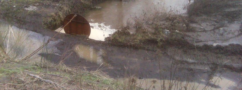
23Drainage System Maintenance
The City’s Public Works department, working along-
side Drainage District 23, maintains the drainage
system, including catch basins and the Oxbow flood
gate. The importance of this is demonstrated below:
During the January 2009
flooding, it was discov-
ered that a beaver dam
was blocking the flood
gate. This meant that
the Oxbow wetland,
which runs along the
Radiance housing devel-
opment, was
unable to drain
into the river as
designed, and
the City’s Pump
Station #12,
located nearby,
was threatened
by flood waters.
Once the gate
was cleared of
debris, the
danger to the
pump station
was alleviated.
Monitoring to
prevent this from
reoccurring is
now routine.
24What YOU Can Do in Advance
Fife’s citizens are encouraged not to delay in preparing
for any disaster, and that certainly includes floods, the
most common and widespread of all natural disasters.
Remember that the sheer force of
just six inches of swiftly moving
water can knock people off their
feet, and cars are easily swept away
in just two feet of water.
Please, take these steps today:
Prepare for a Flood
• Purchase flood insurance from the National
Flood Insurance Program, through your local
insurance representative.
• Store insurance papers, deeds, and other
important records in a safe-deposit box or other
secure location.
• Keep this booklet handy and refer to it often.
• Be aware that the City of Fife and Pierce County
Emergency Operations Centers will be open in
emergency situations, coordinating and facilitat-
ing resources to minimize the impacts.
• Know that sandbags are available at Fife City
Hall. Also, learn of other items on the market,
such as HydraBarrier, a reusable sandbag
alternative, pictured below.
25• Prepare an emergency kit that includes at least
one large flashlight, a battery-powered radio,
spare batteries, candles, waterproof matches, and
other items you’re likely to need in the event of a
power outage.
Prepare Your Home
• Elevate your furnace, water heater, and electric
panel if they are susceptible to flooding.
• Install “check valves” in sewer traps to prevent
floodwater from backing up into drains.
• Seal basement walls with waterproofing
compounds to avoid seepage.
• Keep family heirlooms and other priceless
possessions on an upper level, if possible, or in
locations within your home that are least likely to
flood.
Prepare for an Evacuation
• Make a list of items to
take with you in case of an
evacuation (for example,
clothing, cash and credit
cards, prescription medica-
tions, eye glasses, mobile
phone, etc). Keep this list
in a handy location.
• Listen to the National
Oceanic and Atmospheric
Administration weather
radio. (NOAA)
26Prepare for an Evacuation (continued)
• Familiarize yourself with Fife’s predetermined
evacuation routes (see page 20), mapping out
which one will best serve your family in the
event of an emergency.
• Keep your vehicle full of fuel.
• Learn where official shelters are located and plan
your route to the nearest shelter or other safe
area. Consider whether any locations along your
planned route might flood. Also consider what
to do with pets; most shelters can’t keep animals.
Useful websites:
• http://www.fema.gov/areyouready/flood.shtm
• http://www.bt.cdc.gov/disasters/floods/
• http://www.ready.gov/america/beinformed/
floods.html
• http://www.co.pierce.wa.us/pc/abtus/ourorg/
dem/pubed.htm
A sampling of products available to protect your property:
• www.hydrabarrier.com (pictured on page 25)
• www.floodprotectionproducts.com
• www.hydrologicalsolutions.com
• www.stormtec.net
• www.aquadam.com
27What does it mean to live
behind a levee?
How much protection does a
levee really provide?
What do you need to know to
remain as safe as possible?
V|àç Éy Y|yx
5411 23rd St E
Fife, WA 98424
253-922-2489You can also read