WITH STEVE LANORE, CBM MARCH 29, 2019 - "LIKE SOMEONE ALMOST JUST TOOK A GIANT KNIFE AND SCRAPED THE GROUND " - CRU ADJUSTERS
←
→
Page content transcription
If your browser does not render page correctly, please read the page content below
With Steve LaNore, CBM
                               March 29, 2019

"Like someone almost just took a giant knife and scraped the ground…”
-   Sheriff Jay Jones, Lee County Alabama

"I'm still thanking God I'm among the living," said John Jones, a resident of Beauregard, a hodge-podge
zone of homes, farms and workplaces (not a traditional city) in Lee County, Alabama. About 10,000
people live in this region near the Georgia state line.

The EF-4 tornado with top winds estimated at 170 mph showed up about 3 p.m. on March 3, tracking
along a 26-mile long mile-wide path as it claimed 23 lives and laid waste to hundreds of homes and other
structures. In a terrible twist of fate, ten of the victims were from the same family.

The Lee County Tragedy was part of a powerful storm system that crashed through the South, spawning
38 separate twisters across several southern states. It was the strongest; this one storm killed more
people than all of 2018’s tornadoes put together. It was the deadliest tornado in the nation in the past six
years. Remarkably, total property losses were rather low due to the rural settings for most of these
tornadoes – perhaps $100 million or for all of them combined – five times less than the Collin Co., TX
hailstorm covered later in this newsletter.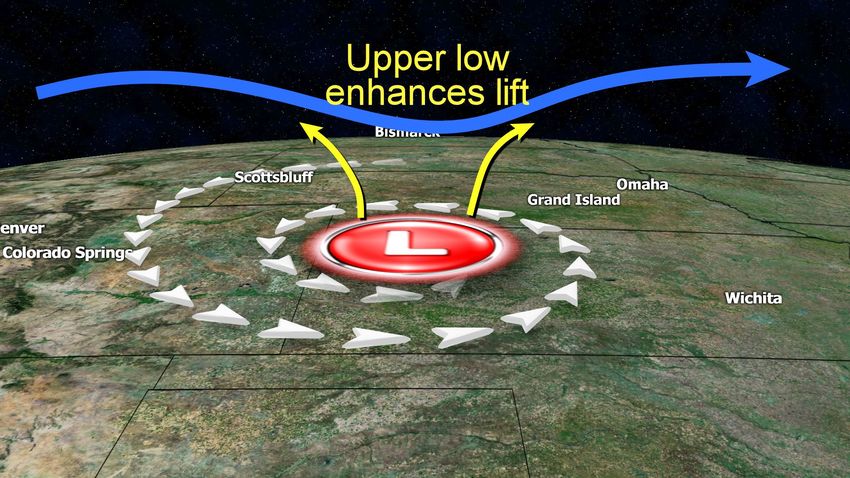
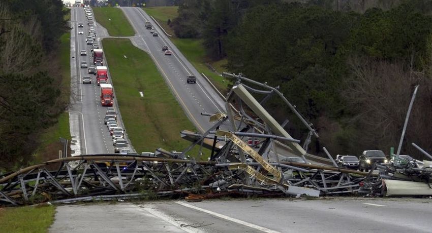
The Lee County, AL tornado on radar...note the classic “hook”...it was doing major damage at this time.

Four of the 23 fatalities occurred on mobile homes – a surprisingly low figure given the high number of
mobile homes in this part of the South. Nationally, 44 percent of all tornado deaths happen in mobile
homes, while only eight percent of the population live in them, a telling statistic.

  The tornado downed this cell tower, blocking U.S. Highway 280 in Lee County, AL / Mike Haskey / AP
The tornado grinding its way through the forested Alabama countryside. – A tough place to track
                                        tornadoes / Severe Studios / Scott Peake

                        The Lee County tornado as seen from a drone located south of the funnel.

Perhaps the hardest-hit area damage-wise is the town of Cairo, Georgia, where an EF2 spent just a few moments
on the ground as it cut a 4,800 yard (2.70 mile) long path at a forward speed of 30 mph, in that short time it did
perhaps $10-$20 million in damage.

The Mesonet station near the city reported a peak gust of 102 mph while National Weather Service (NWS)
meteorologists say winds a little stronger in the 111 to 135-mph range occurred. Two people were injured in this
storm that local residents are calling “two minutes of terror”.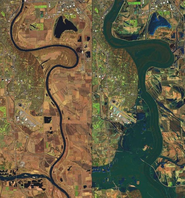
Cairo, GA: The two images above and the one below from Tori Schneider at the Tallahassee Democrat.
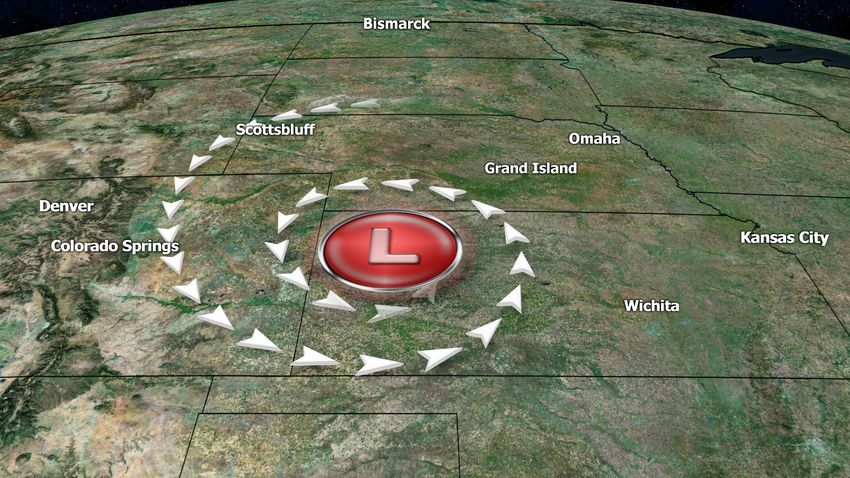
Cairo, GA took a big-time beating at the hands of this EF2.

This Late-Winter Storm was definitely not “The Bomb”
The slang phrase ”The bomb” often means really great, as in “man, that steak was the bomb”. Well, a mid-March
storm given that name because it intensified extremely fast was anything but great. It was fierce and relentless. It
caused widespread wind damage and catastrophic flooding, Nebraska and Iowa took a gut-punch in the flood
zone while Colorado got the worst of the blizzard side. Overall, more than a half dozen states were affected from
Texas to South Dakota.

To understand what caused “The Bomb”, we look at the air flow around a typical low-pressure system. As low
pressure forms air spirals in toward the center, rising as it does, think of a giant corkscrew of air flow. Meanwhile,
the rising air has to go somewhere, and as it rises several miles above the earth it begins to flow away from the
low, allowing more air to blow in.

With “The Bomb” (some called it “bomb-o-genesis”) an upper level low approached in just the right way to cause
a sucking effect above the surface low, this forced a lot more air to spiral up into that corkscrew, at a much faster
rate than usual, causing a strong pressure drop at the surface. Pressure and winds are directly related, so when
this happened the air at ground level had no choice but to “rush” in to balance the force. So what made this
storm so intense was the rate at which the pressure dropped, allowing surface winds to reach hurricane force
gusts in at least three states. Once the upper low moved away, its effect disappeared and the system began to
steadily weaken within a day and a half.
Air spirals in toward the low-pressure center at the ground…

         The “Bomb” storm wound up pretty tight as it moved over NW Kansas March 13 / NOAA image

Above: The air rising from below is vented out with much greater force when there’s an upper low above it. The
yellow arrows show air rising from the surface low being diverted away from the system at higher altitudes,
making room for more air to race upward from below. This helped make “The Bomb” possible.

So much for the science…here’s what it did: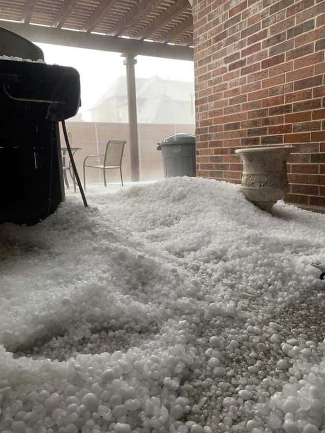
Before the flood (left) and after the flood (right) along the Missouri River / NOAA

So perhaps calling it “The Bomb” fits because it really blew it up fast, and then just like a bomb the
debris…flooding, downed trees, snow-choked roads…. Settled in and it faded away. What a mess. For Nebraska,
torrential rain into ice-choked rivers led to the “perfect storm” of flood disasters, as the natural dams created by
the ice allowed for tremendous pooling...and then sudden release…of floodwaters as the ice dams broke:

                       From the ground: Fremont, Nebraska flooding / The Weather Channel

According to National Public Radio reporters, Nebraska alone suffered over $1.3 billion in damage, the storm
total is over $2 billion for the several states affected. Amazingly, the death toll was very low at just four people –
a testament to the better warnings and superior emergency response to stranded people available today. Even
Offutt Air Force Base – A key “SAC” base in the U.S. air defense network…had some 30 buildings flooded.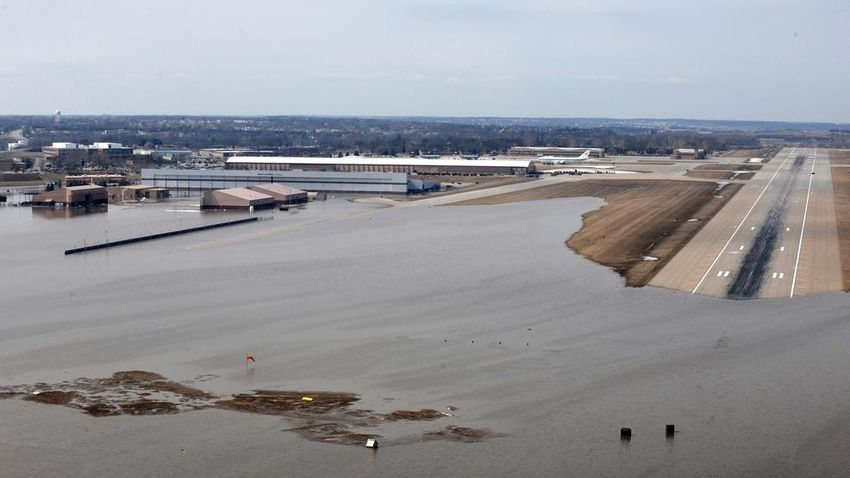
Offutt AFB flooded / U.S. Air Force photo by TSgt. Rachelle Blake

    Airline passenger Christopher Heady posted this Tweet while landing in Omaha...”Pretty surreal flying into
                                      Omaha. Highways fully submerged.”

Nebraskans are a hardy bunch, and just like after the floods of 2011 they will recover…but many farmers and
smaller farm communities may never be the same. It’s truly life-altering and game-changing experience for the
central part of the state. From an insurance point of view.
The Collin County, TX Blues: Another Helluva Hailstorm
Collin County, Texas has been one of the Top 10 fastest growing counties in the U.S. for several years, meaning
increasing construction, more jobs, higher home values, and all that goes along with it on the insurance side –
more claims, and higher dollar figures, when the weather turns sour.
Almost without fail, each spring brings some sort of significant hailstorm to the DFW Metroplex, but when we
look at the past three years, the pummeling taken by Collin County has been almost ridiculous, and certainly very
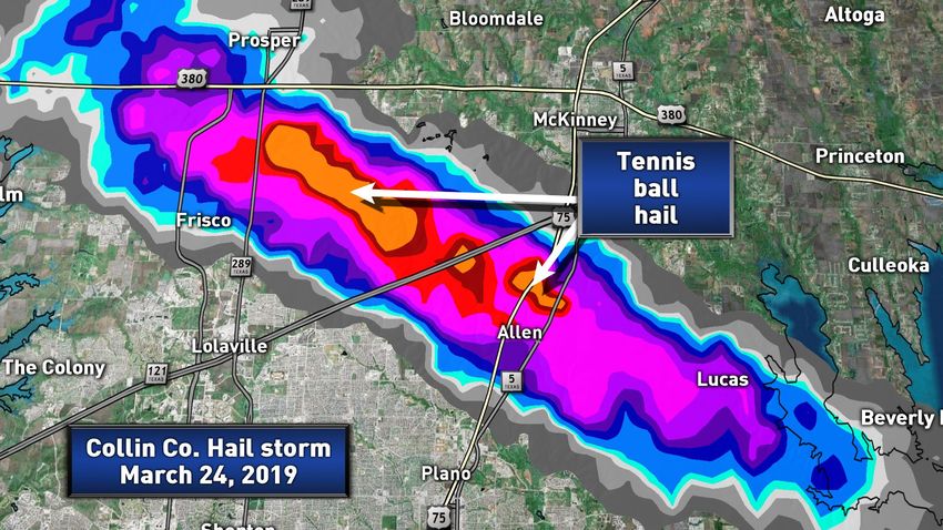
unlucky. The latest entry in the Book of Devilish Hailstorms was penned on March 24, 2019.
Storms firing head of a cold front and upper trough began to intensify quickly over Denton County before moving
eastward into Collin County, home to just about one million people. It was a quickly-changing situation as
warnings for quarter sized hail over Denton turned into golfball, tennis ball and in a few cases baseball hail a half
hour later over Frisco and McKinney. The hail fell for 20 minutes…a long time…piling up in some cases in drifts
several feet deep:
Hail in Allen, TX piled up: notice these are not pebbles, but golfball-plus hailstones / Dean Smith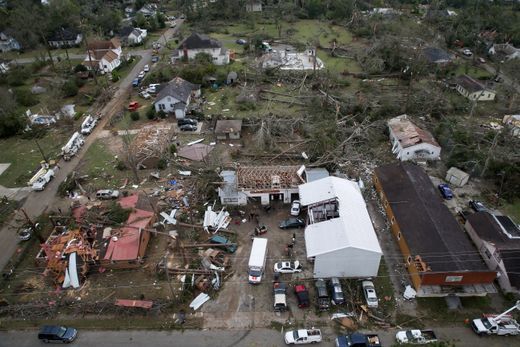
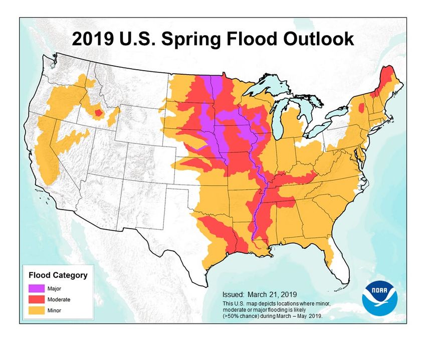
So, what’s Ahead for April?
The National Center for Environmental Prediction (NCEP) outlook for spring 2019 suggests that we will continue
in a pattern that is terrible news for the middle of the nation…and perhaps the west as well. Ironic, because
California is now dancing from a parched partner of long-term drought to a soggy salsa of excessive rainfall and
snowmelt.

Nearly two-thirds of the Lower 48 states face an elevated risk for flooding through May, with the potential for
major or moderate flooding in about two dozen states, says NOAA’s U.S. Spring Outlook issued in late March:

The NOAA spring outlook for 2019 is anything but good news for flood-ravaged portions of California, and even
more so for most for the country east of I-35. This interstate runs from the Mexican border through Dallas and
northward into Nebraska. We’re talking a HUGE chunk of the U.S. under an elevated flood risk. Time to beef up
flood insurance as areas that normally don’t flood may this spring. Why? River flows are already high from record
March rain and snow melt along the Missouri basin, and a persistent wet pattern east of the Rockies coupled
with warming temperatures spells trouble. The year 2019 may well be the “Year of the Flood”.

There’s no clear signal on severe weather, as always April-May deals a few surprises every year, enhanced wind
shear from a weak El Nino point to more events like we saw in Alabama-Georgia on March 3.
So, here are some likely adjuster hot-spots in April-May:
West Coast: Mudslides and flooding from spring rain and heavy melt-water runoff

Middle America: FLOODS. Could be epic…they have already been so in Nebraska. Stay tuned.

Mid-South/Southeast: Persistent jet stream flow with a parade of upper lows suggests more significant tornado
outbreaks….fewer than average in “Tornado Alley” because these regions will be on the stable side of this flow.

PLEASE NOTE: It only takes one “bad” tornado to gain national attention as we saw with the March 3 outbreak. I
expect “Tornado Alley” tornado occurrences to be below average; I cannot speak as to whether that means they
will hit a populated area. No one can…at least on this planet!

 Take Care,

 Steve LaNore, CBM

 Author, “Twister Tales: Unraveling Tornado Myths”, available on Amazon
You can also read