2018 Guidebook - Updated 3.17.18 - Ville to Ville Craft Brew Relay
←
→
Page content transcription
If your browser does not render page correctly, please read the page content below

2018 Guidebook

                 Updated 3.17.18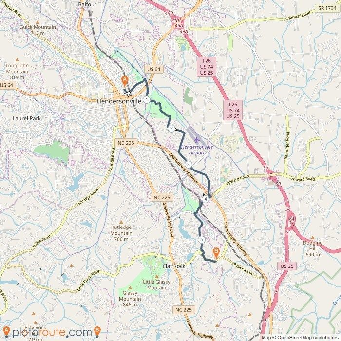
OUR SPONSORS
OUR CHARITIES

We are proud that our inaugural event will raise an estimated $15,000 to support our 2018
Charities of Choice. Please consider a personal donation to these wonderful organizations that are
addressing the food crisis in Asheville and Greenville.
TABLE OF CONTENTS
SECTION A - Introduction to the Ville to Ville Craft Brew Relay………………...6-8
     1.   Race Format and Overview
     2.   Team Captain Role
     3.   Runners - Transitions and Rotations
     4.   Vehicles
     5.   Drivers
SECTION B - Before the Race ……………………………………………………………………….9-13
     1. Captain Checklist
     2. Age Requirement
     3. Team Roster - Changes and Deadlines
     4. Time Predictions
     5. Team Spirit
     6. Training
     7. Preparing to Run the Course
     8. Preparing to Drive the Course
     9. Lodging and Van Rental
     10. Communication
     11. Packet Pick-Up and Kick-Off Events
     12. Volunteer Requirement
     13. Inclement Weather Policy
     14. Charities
     15. Refund Policy
SECTION C - Team Type, Divisions, and Contests ……………………………………..14
     1. Number of Team Members
     2. Divisions and Awards
     3. Contests
SECTION D - Rules and Safety ………………………………………….………………………..15-19
     1.   Rules and Safety for Runners
     2.   Rules and Safety for Drivers and Vehicles
     3.   Rules for Everyone
     4.   Emergency and First Aid Information
     5.   Rules Enforcement
     6.   Penalties and Disqualification
SECTION E - Running the Relay …………………………………………………………………..20-21
     1.   Starting Times
     2.   Van Signage and Bib Numbers
     3.   Transition Areas for Runners
     4.   Transition Areas for Drivers & Vehicles

                                                                              4
TABLE OF CONTENTS
SECTION E - Running the Relay (continued) ……………………………………………...20-21
    5. Projections versus Reality
    6. Timing
    7. GPS Tracking
    8. Running in the Dark
    9. Staying on the Course
    10. Vehicle Support
    11. Food and Hydration
SECTION F - The Race Course ……………………………………………………………………..22-34
    1. Leg #1 - The Hiker
    2. Leg #2 - The Hillman
    3. Leg #3 - The Firefly
    4. Leg #4 - Howard’s Gap
    5. Leg #5 - Hendo
    6. Leg #6 - The Oklawho?
    7. Leg #7 - The Pickler
    8. Leg #8 - Tali-Ho!
    9. Leg #9 - Inverted
    10. Leg #10 - The Beech
    11. Leg #11 - The Rabbit
    12. Leg #12 - The Commons
    13. Major Transition Area Opening, Closing, and Hold Times
    14. Leg Difficulty and Ratings
SECTION G - Individual Runner Tips …………………………………………………………...35
    1.   Be Prepared
    2.   Warm Up/Cool Down
    3.   Energy and Hydration
    4.   What to Do When Not Running
    5.   Clothing and Shoes
SECTION H - Checklists ………………………………………………………………………………..36-37
    1. Master List
    2. Individual List
    3. Team List

                                                                      5
SECTION A - Introduction to the Ville to Ville Craft Brew Relay
1. Race Format and Overview
The Ville to Ville Craft Brew Relay celebrates the beautiful region from Asheville,
NC, to Greenville, SC. This 73-mile team running event travels from the peaks to
the foothills of the Appalachian Mountains, through local craft breweries, and into
quaint southern towns.
Held on April 14, 2018, teams of 3 to 6 runners will split 12 legs ranging from 3.5
to 9.8 miles. Teams will provide their own vehicle to drop off and pick up
runners at designated transition areas along the course route. Starting at
Highland Brewing Company, teams will travel through two local craft breweries
(Southern Appalachian and Swamp Rabbit Brewery) before arriving in Greenville
for a finish line celebration which will include music, food, and of course, craft
brews.
The Ville to Ville Craft Brew Relay focuses on delivering the highest quality
one-day running relay experience. All participants are required to read this
guidebook and are responsible for knowing the contents.
This guide will provide you with race details and tips to help you have a great
experience in the Carolinas. Due to the nature and distance of this event, late
changes are possible and all participants are encouraged to utilize our
communication system described in Section B to ensure they receive all the
latest updates.
As you read through, it is important to note that participant safety is our number
one priority. As you prepare for this fantastic experience, please remember that
this is an open roads event and that you need to plan to run accordingly.

2. Team Captain
Every team must designate a captain who will lead and communicate with the
team. It is very important that the captain relay important race information and
updates from Ville to Ville Headquarters (V2V HQ) to all team members. If for
some reason a new captain needs to be assigned, V2V HQ should be notified
immediately.
The captain is responsible for making sure the Team Member Form is complete
by February 14, 2018 and void of errors. The captain is also in charge of
recruiting a team volunteer (if required) and making sure estimated pace times
are accurate, race fees are paid, and the team running order has been assigned.
All communication to V2V HQ from the team should go through the captain.

                                                                                      6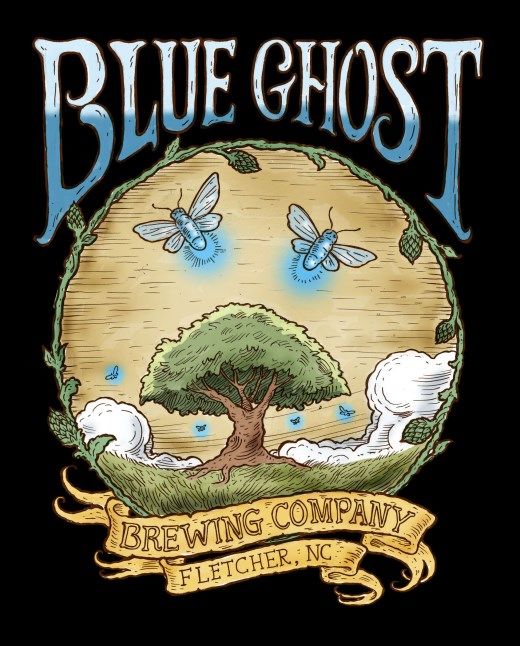
SECTION A - Introduction to the Ville to Ville Craft Brew Relay
3. Runners - Transitions and Rotations
A typical V2V relay team consists of 6 runners, with each runner covering two
legs of varying distances and difficulty. Course legs range from 3.5 miles to
9.8 miles. All individual course legs can be viewed on our website. On average,
each leg is approximately 6 miles and the two-leg total for 6-person teams is
12.2 miles. Section F in this Guidebook will cover each leg of the course in detail.
Teams will collectively cover 73 miles by rotating runners through 12 total legs.
When a runner completes a leg, he/she will hand off the team wristband to the
next runner and will not be allowed to continue running directly to the next leg.
Each team member must run one leg before any team members run a second leg
and it is recommended to run in the same order for the entire relay. Ultra teams
of three runners may run more than one leg and can continue through the
transition, after checking in with a transition volunteer.
There will be a total of 11 transition areas along the course. These transition
areas are the set locations where one runner passes the team wristband to the
next runner. The transition areas are the same for every team and will be
staffed by race volunteers to record team numbers and times. Although 6-
member teams are the norm, we welcome team sizes of 3 (Ultra), 4, and 5
members. The recommended legs and total mileage for each team size is below:
Teams    of Three
Runner   #1 - Legs   1, 4, 7 and 10 - Total Miles = 26.2
Runner   #2 - Legs   2, 5, 8 and 11 - Total Miles = 20.9
Runner   #3 - Legs   3, 6, 9 and 12 - Total Miles = 26.2
Teams    of Four
Runner   #1 - Legs   1,   5   and   9 - Total Miles = 17.4
Runner   #2 - Legs   2,   6   and   10 - Total Miles = 21.5
Runner   #3 - Legs   3,   7   and   11 - Total Miles = 16.4
Runner   #4 - Legs   4,   8   and   12 - Total Miles = 18.0
Teams    of Five:
Runner   #1 - Legs   1, 6 and 11 - Total Miles = 18.0
Runner   #2 - Legs   2, 7 and 12 - Total Miles = 19.3
Runner   #3 - Legs   3 and 8 - Total Miles = 9.1
Runner   #4 - Legs   4 and 9 - Total Miles = 11.9
Runner   #5 - Legs   5 and 10 - Total Miles = 15.0
Teams    of Six
Runner   #1 - Legs   1   and   7 - Total Miles = 10.7
Runner   #2 - Legs   2   and   8 - Total Miles = 9.5
Runner   #3 - Legs   3   and   9 - Total Miles = 11.8
Runner   #4 - Legs   4   and   10 - Total Miles = 15.6
Runner   #5 - Legs   5   and   11 - Total Miles = 11.3
Runner   #6 - Legs   6   and   12 - Total Miles = 14.4

                                                                                       7
SECTION A - Introduction to the Ville to Ville Craft Brew Relay

4. Vehicles
Due to the race course traveling 73 miles, teams are largely self-supporting
during the event. Your team will provide its own food, water, sports drinks, and
first aid items. While the primary function of your vehicle is transportation, it is
also your home base during race day and should be stocked appropriately. Look
in Section H for our recommended checklist for each vehicle.
Teams are limited to just one vehicle on the route. Appropriate team van
signage (provided by V2V at check-in) will be required for vehicles to enter each
transition area. It is recommended that teams use vans, mini-vans, or large
SUV’s during race day. For safety reasons, RV’s, mini-buses, trailers, and limos
are prohibited. All passengers must have access to a seat belt.
Once the hand-off is made between your runners at a transition, your vehicle
needs to leave the designated transition parking area in 10 minutes or less and
start heading towards the next transition area. This will allow the next runner to
prepare, warm-up, and be ready for his/her leg.
Vehicles should never stop or try to interact with runners on the course unless
there is an injury or a runner is off course. Vehicles are required to take the
designated driving path on the course. Details of each driving path can be found
in Section F.

5. Drivers
While teams are not required to have a designated team driver, it is something to
consider, as it allows all runners to rest and gives the driving responsibilities to a
non-runner. All drivers that are not participating in the relay will be required to
sign a waiver at packet pickup or at the starting line. Teams that do not have a
designated team driver should plan to share the driving responsibilities during
the relay.
The vehicle driver should know each route, ensure the team’s safety, and help
serve as a protector of all runners on the course. For the safety of runners and
for optimal traffic flow, drivers should be aware of the designated driving path
and follow that path despite what GPS directions may suggest. Speeding and
reckless driving will not be tolerated and will result in team disqualification.

                                                                                         8
SECTION B - Before the Race
1. Captain Checklist
Recruit your team! Six person teams are ideal and recommended.
Pay the balance due for your team before the deadline on January 15, 2018.
Complete your Team Member Form before the deadline on February 14, 2018.
Review the race course with your team.
Find a vehicle to use during the race.
Reserve start and finish line hotels.
Plan for team contests.
Ensure you have the required visibility gear for legs in the dark.
Gather adequate food, drinks, and first aid supplies.
Print a copy of the guidebook for the vehicle.
Have a fun, memory-filled Ville to Ville Craft Brew Relay!
2. Age Requirement
All team members must be 21 years or older to participate. No exceptions. All
runners will be required to show a valid government issued photo ID during
check in and sign a waiver verifying their age.
3. Team Roster - Changes and Deadlines
After registration, each captain will receive a link to an online Team Member
Form. Captains can share this link with team members so that they can
individually provide their personal information needed by V2V HQ.
A portion of the Team Member Forms will be locked for editing on February 15,
2018. The locked areas will be Team Name, t-shirt sizes, and team pace. You
will be able to edit team member info, add/remove teammates, and change cate-
gories until March 31, 2018. If for some reason changes must be made after this
deadline, the captain must email info@villetovillerelay.com with the updated in-
formation. Change requests after Sunday, April 1st, will carry a $25 fee and all
updates must be made at packet pickup. Again, changes after February 14th will
not change your teams starting time or shirt sizing order.
9
SECTION B - Before the Race

4. Time Predictions
We ask that each participant give us a 10K race pace prediction (in minutes/mile)
on the Team Member Form. The captain should then use these individual
predictions to estimate the total team pace on the Team Member Form. We need
these predictions to be as accurate as possible so that teams can be assigned the
appropriate starting times. Accurate times also allow us to have adequate
spacing between teams and vehicles on the race course. The slowest team pace
allowed is 10 minutes and 30 seconds per mile on average for the entire relay.
Team time predictions are due on February 14, 2018.
Teams should not stray more than one hour from their estimated total team
time. Teams with inaccurate pace predications may be asked by the race
directors to either wait at a transition area before the next runner can start or
they may be forced to skip one or more legs of the course. This is one of the
most important pieces of information we get from our teams, so please be as
accurate as possible.
5. Team Spirit
We’ve got spirit, yes we do, we’ve got spirit, how about you? The Ville to Ville
Craft Brew Relay is the perfect opportunity to have a great time with your
friends. Deck out your vehicle, wear crazy costumes, invest in a team shirt and
be creative! There will be prizes. Our 2018 Theme is Support Local, so plan to
support your hometown, state, region, country, team, etc.
Our desire is that you have fun on the course, but please do so responsibly. We
are running through local communities that have embraced our relay with
support and volunteers. V2V HQ has the right to ban or prohibit offensive team
material.
6. Training
While running 73-miles solo sounds overwhelming, the beauty of our relay is that
it is for every runner out there. With 6-member teams, each participant has
roughly a half-marathon to complete during the day. Of course you have to be
prepared, and we suggest you complete at least a couple of training days with
double runs. Running on tired legs 24 hours later is a lot different than running a
second time during the same day.
For six member teams, our advice is to train as though you are going to run a
15K. Prep for that and you will have an easy day. We do have two different 12-
week training plans on our website if you want some suggestions.

                                                                                      10
SECTION B - Before the Race
7. Preparing to Run the Course
Unlike your typical road race, team relay courses are not closed to traffic. You
will share the road and greenways with cyclists, pedestrians, and, most
importantly, vehicles. We have worked hard to keep our runners on less-traveled
roads, but everyone should be prepared to run safely, with traffic in mind. Treat
your runs on the V2V course as you would if you went out your front door for a
run on the road.
All runners should follow the rules of the road and normal pedestrian traffic laws
while they are running. Unless otherwise noted, runners should run against
oncoming traffic.
All teams and individuals are ultimately responsible for staying on course. The
route will be marked with directional signs and volunteers will assist you, but it is
important to remember that it is your responsibility to stay on course. For that
reason, take plenty of time before the event to study your individual legs.
Detailed leg maps and directions are available in Section F of the Guidebook.
Some legs are simple and some have a number of twists and turns. If you get
lost easily, we recommend you print, laminate, and carry the map and directions
with you on the course or download the maps to your phone to carry with you.
8. Preparing to Drive the Course
We strongly suggest that teams drive the course in advance, if possible. If
driving the course in advance is not possible, we recommend that drivers for
each leg study the driving directions in Section F of this Guidebook and know the
route before taking the wheel on race day. Remember, follow the map and not
your GPS.
Vehicles should move quickly from one transition area to the next; therefore
there is not much time for getting lost. There is nothing more frustrating for a
runner than finishing his/her leg and having to wait on the team vehicle to arrive.
9. Lodging and Van Rental
April is a busy time of year in Asheville and Greenville so we advise booking your
hotel rooms as soon as possible. If you have an early start time in the race, you
may want to book a room in Asheville on Friday and Greenville on Saturday. If
your start time is a bit later, it may be best to plan your whole stay in Greenville.
We highly recommend that all teams have at least a mini-van or large SUV for
transportation. Most of the day, you will have five sweaty people in the vehicle.
Make sure you have space. To see special rates and links for lodging and van
rental, please visit our website.
11SECTION B - Before the Race
10. Communication
We will use the Remind App to send important pre-race, race day, and post-race
text updates. You can join by text or by downloading the Remind app.
Join by text: Text @V2V2018 to 81010.
Get App notifications: Download Remind app. Join the @V2V2018 class and
you will automatically get app notifications.
We understand getting in touch with race directors on race day may be critical.
If you have a race-related emergency, please contact us via text through the
Remind App, text us at 803 .728.4553, or email us at hq@villetovillerelay.com.
For REAL emergencies (medical or law enforcement), please call 911.
Also, make sure you put your cell number on your Team Member Form. If we
need to reach your team on race day, we will call! We also recommend that all
team members have the cell phone number of all other team members. And
while we are not big fans of running with a phone, we do recommend that all
runners carry their phone with them while on the course - for safety, GPS
tracking, and communication reasons.
11.Packet Pick-Up and Kick-Off Events
It is recommended that all team members come to packet pick-up to confirm
contact information, sign the waiver, and show their IDs. Each team member
will get a race packet that will contain the race shirt, bib, SWAG and other cool
items.
Packet Pick-Up locations:
Greenville - Thursday, April 12 - 5:00-7:30pm - Aloft Downtown Greenville,
5 North Laurens Street, Greenville, SC 29601
Asheville - Friday, April 13 - 4:00-8:00pm - Highland Brewing Company,
12 Old Charlotte Highway, Asheville, NC 28803
There will be a runners’ welcome party at each packet pick-up location. Visit our
social media sites for more information!
12.Volunteer Requirement
If anyone on your race team lives within 100 miles of Asheville, NC, or
Greenville, SC, you are required to provide one race-day volunteer. Don’t feel
like providing a volunteer? Just pay the $100 volunteer fee and we will work
with one of our local non-profits to provide a volunteer...and the non-profit
benefits! Volunteer information can be indicated on your Team Member
Form. Have more than one volunteer? Just email us.
12SECTION B - Before the Race
13. Weather and Inclement Weather Policies
Average April temperatures in Greenville and Asheville range from a low of 45
degrees to a high of 71 degrees. Cooler temperatures can be expected at the
higher elevation in Asheville. Average rainfall for the entire month of April is
about 3.5 inches. However, if it does rain in the spring, it is usually not a
significant amount.
The relay will occur under a wide range of weather conditions and in general will
not be canceled due to weather. However, severe weather may result in a
delayed, altered, or canceled event. Such weather conditions may include, but
are not limited to, electrical storms, snow, ice, hail, lightning, wind, tornado,
flooding and extreme cold or heat. Any event delays, alterations, or cancellations
will be communicated to the captain/team through our mass text service and
email.
If lightning occurs during the race, get your runner off the road and into the
team vehicle if possible. Make a note of the time and location where the runner
stopped. If the lightning clears within 30 minutes, put your runner back on the
course where he/she left, and make a note of the time. If lightning persists
longer than 30 minutes, proceed to the next transition area. For every 30
minutes of a lightning delay, please move ahead one transition area. Please turn
in any lightning delay information and times to the timing company at the finish
line. Adjusted results will be calculated.
14. Charities
The Ville to Ville Foundation was created to make a difference in our
communities. In 2018, the foundation has chosen Feed and Seed SC in
Greenville and the Food Connection in Asheville as our Charities of Choice.
Although we are in our inaugural year, we are planning to help raise $15,000 to
support these two wonderful organizations. We invite you to visit our Charities of
Choice at the finish line or online.
15. Refund Policy
All entry fees are non-refundable and non-transferable. This is a typical policy for
this type of event since a limited number of teams can be accepted. Once you
have registered, you will not receive a refund if you are unable to participate for
any reason, nor can your fee be transferred to another team or applied to the
next year. Sorry, no exceptions.
13SECTION C - Team Type, Divisions and Contests
1. Number of team members
Team sizes of three (Ultra), four, five and six are allowed. Please review Section
A for legs and mileage for each runner. For awards and prizes, teams of four to
six will be grouped together.
2. Divisions and Awards
All teams must compete in one of the following divisions and divisions will be
chosen by the Captain on the Team Member Form.
Ultra Female - Three females
Ultra Male - One to three males
Open Co-Ed - Minimum of two females
Open Male - All male or all male and one female
Open Female - All female
Masters Co-Ed - Minimum of two females, all team members age 40+
Masters Male - All male or all male and one female, all team members age
40+
Master Female - All female, all team members age 40+
Awards will be given to the top three fastest teams in each division unless there
are five or fewer teams in a division. If there are five or fewer division teams,
only the top team will win an award.
3. Contests
All contest winners will be announced at the post-race party.
Best Team Costume - Wear it all day long and the more outrageous, the
better!
Best Vehicle Decoration - Your vehicle has to be awesome and street legal.
Please don’t create a safety threat with empty kegs on top of your mini-van!
Best Social Media Post - We love social media! The post that tags us on both
Instagram and Facebook that we love the most will win. If your team doesn’t
have its own social media page, then it should.
Best Team Spirit - Fun teams create a fun environment for all. Show your
team spirit along the entire course. Our volunteers will be voting for this
winner, so make sure they feel your love!
All contest rules will be announced prior to the event.
14SECTION D - Rules and Safety
1. Rules and Safety for Runners
Running Order - Team members should run in a fixed order and will be
considered fixed once a runner begins his/her first leg. You can decide your
running order at any time and it does not need to be communicated to the
race directors.
Running in the Dark - Any runner starting a leg at 7:30am or earlier is
required to wear visibility gear (see requirements below). Also, later legs may
be required to wear visibility gear based on weather and will be instructed at
each transition area if it is required.
Required Visibility Gear - All teams must have at least two reflective vests,
two headlamps, and two blinking LED taillights. These items will have to be
shown to the safety volunteers at the starting line check-in for a team to start
the relay. Shirts with reflective gear will not qualify as a reflective vest. Here
are links to acceptable items:
Safety Vest | Headlamp | Blinking LED Light
Official Race Bibs - All runners are required to wear the issued race bib so
they are visible from the front. Teams must wear the issued bibs in order.
Numbers should end in 1 for the first runner, 2 for the second runner, etc.
Personal Devices and Headphones - The use of personal music devices with
headphones or earbuds is prohibited. Again, this is an open roads event and
runners will pass vehicles, other runners, and cross intersections. Runners
must be alert and aware of their surroundings at all times. It is recommended
that runners carry a cell phone while running in case there is an emergency.
We also recommend that runners utilize our GPS runner tracking system
detailed in Section E.
Injuries and Substitutions - If for any reason a runner cannot continue or
complete a leg due to injury or sickness, and the team decides to continue the
relay, then another runner (already on the team) may finish that leg. The
remaining team members may split the remaining legs assigned to the
injured/sick team member. However, only one runner is allowed per
remaining legs.
Transition Exchange - Each team will have a slap bracelet that must be passed
from one runner to the next in the designated Transition Zone at each
transition area. The slap bracelet should be returned to a race volunteer at
the finish line.
15SECTION D - Rules and Safety
1. Rules and Safety for Runners (continued)
Signage and Direction- Runners should follow all relay directional signage and
know running routes prior to the event. We recommend carrying water, a cell
phone, and a map of your leg while running. Runners should run against
traffic on all roads unless instructed otherwise.
Going off Course - Runners who make a wrong turn must return to the course
where they left it and continue on the correct route. Runners may use
transportation to return to the correct route as long as they complete the
entire leg without vehicular assistance.
Traffic Laws - Unless a law enforcement official directs you otherwise, all
runners must obey pedestrian traffic laws on the course. Runners are
required to stop at red traffic signals and wait until a green signal or walk sign
has appeared.
Railroad Tracks - Runners will cross a few railroad tracks along the course.
Although the railroad companies are aware of our relay, runners should not
attempt to cross a track with a train in the crossing area. If runners do have
to wait for a train, simply note the total wait time and report that to the
timing official at the finish line and we will adjust your team time.
Getting Ahead - Teams that are too far ahead of their estimated pace at
transition areas #3, #6 and/or #9 may be required to wait a minimum of 75
minutes at the transition area until the re-start time. Team pace estimates
are critical in determining your starting time and also the time for volunteers,
support, and course coverage at each transition area. If your team is held, we
will subtract the hold time from your final time, but you will receive a 30
minute penalty and will not be eligible for any awards. Please see Section F for
specific details.
Getting Behind and Skipping Stages - Teams that are behind their estimated
pace by more than 60 minutes at transition area #3, #6 and/or #9 may be
required to skip the next leg (and possibly more legs) in order to meet the
appropriate time window for each transition area and the finish line. Team
Captains will be notified by V2V HQ or by the lead volunteer at the transition
area if this adjustment is necessary. If teams feel that they may need to skip
a leg, then they may contact V2V HQ.
Finishing as a Team - There is no better joy for a team than for everyone to
finish together. Teams can meet their final runner in the team gathering area
located approximately a quarter mile before the finish line. Celebrate the last
quarter mile together, but please make sure your timing chip (on the back of
bib #3 (ultra) or #6 (regular) crosses the finish line. Then go
grab a craft brew and celebrate!
16SECTION D - Rules and Safety
2. Rules and Safety for Drivers and Vehicles
Safety First - A significant portion of the race course in on open roads. Always
be careful and watch for runners, volunteers, and other pedestrians on the
race course.
Laws - Team vehicles must obey all speed limits, traffic signs, and all traffic
laws.
Runner Support - Vehicles should not stop and interact with runners on the
course unless there is an injury or a runner has made a wrong turn.
Driving Directions - Vehicles are required to use the driving directions
provided in Section F and are not allowed to drive on the race course unless
indicated in the directions. The driving directions are designed to eliminate as
much vehicle overlap with runners as possible.
Vehicles Allowed - Teams may use one registered vehicle. It is recommended
that teams use vans, mini-vans, or large SUV’s on race day. For safety
reasons, RV’s, mini-buses, trailers and limos are prohibited. All passengers
must have access to a seat belt.
Vehicle ID Tags - All race vehicles will be issued one ID tag. The tag should
hang from the rearview mirror for the entire relay and will be required for
vehicles to enter parking lots at each transition area.
Parking and Runner Drop Off - At the transition area, team vehicles must park
in the designated areas and follow volunteer instructions. Vehicles may not
stop to discharge runners prior to parking at the official parking lot in each
transition area.
Respect our Communities - The success of this relay depends on the
relationships built with the local residents and communities in which we run.
Please be respectful of the communities and neighborhoods as you run. Do
not park on private property, litter, or block driveways or business access. In
addition, please do not flash lights, honk horns, or play loud music, especially
in the early morning hours.
17SECTION D - Rules and Safety
3. Rules for Everyone
Alcohol Consumption - Consumption of alcohol on the race course is
prohibited. No other substances that could impair driving or good decision
making should be taken or consumed during the race. Having open alcohol
containers in vehicles is against the law. Any team drinking in their vehicle
will be disqualified and the police will be notified. We need safe and sober
participants throughout the relay. Save your drinks for the finish line
celebration!
No Littering - Trash and recycling collection will not be provided on the course
and is the responsibility of each team. Some transition areas will have trash
cans available and there will be trash and recycling containers at the finish line
celebration. Please take care of the communities and roads that we are
traveling by disposing of your trash appropriately.
Restrooms - Portable toilets will be located at each transition area and at the
start and finish lines. Participants should only use the restrooms provided.
Public urination or other public relief is prohibited.
4. Emergency and First Aid Information
Emergency Procedures - In the event of an serious emergency, please dial
911 first. Afterwards, please contact V2V HQ at 803.728.4553 in the event of
any serious injury. Each vehicle should have a basic first aid kit. First aid kits
will also be available at each transition area.
Medical Personnel - There will be limited on-course medical personnel during
the race. There will be on-site EMS staff at the finish line. Here is a list of
emergency medical facilities near the race course if needed:
Mission Hospital, 509 Biltmore Ave, Asheville, NC 28801
Park Ridge Health, 100 Hospital Dr, Hendersonville, NC 28792
Pardee Hospital, 800 N Justice St, Hendersonville, NC 28791
North Greenville Hospital, 807 N Main St, Travelers Rest, SC 29690
St. Francis Downtown, 1 St. Francis Dr, Greenville, SC 29601
Greenville Memorial, 701 Grove Rd, Greenville, SC 29605
5. Rules Enforcement
The rules are in effect to ensure safety and fair play. They are simple and
firm and not open to appeal or negotiation. Penalties include warnings, time
penalties, removal from the course, and disqualification. All relay officials
have the discretion to impose any or all stated penalties.
18SECTION D - Rules and Safety
6. Penalties and Disqualification (continued)
Safety Equipment - Failure to wear required safety equipment during hours of
darkness will result in immediate removal from the course.
Vehicle ID Tags and Bibs - Failure to display vehicle ID tags and/or wear your
race bib while running will result in 1) Verbal Warning; 2) 30 minute time
penalty; 3) team disqualification.
Runner Transition - All transitions between team runners must take place in
the designated transition zone unless there is an on-course injury. A one hour
penalty will result for failure to transition in the proper area.
Transition Zone - Only the runner finishing a leg and the runner that is about
to begin a leg will be allowed in a transition zone. All other participants must
stand clear. Penalties are: 1) Warning; 2) 30 minute time penalty; 3) team
disqualification.
Running on the wrong side of the road - unless specifically instructed on the
course map or by race officials, volunteers, or law enforcement officers.
Penalties are: 1) Warning; 2) 30 minute time penalty; 3) team
disqualification.
Headphones or Earbuds - The use of personal music devices with headphones
or earbuds is prohibited. Any sound amplification device must be worn lower
than the shoulders on an active runner. Penalties are: 1) 60 minute time
penalty; 2) team disqualification.
Incorrect Pace Estimates - Teams that are too far ahead of their pace estimate
and arrive before the opening of transition area #3, #6 and/or #9 will be
required to hold for a minimum of 75 minutes at the transition until the re-
start time. If your team is held, we will subtract the hold time from your final
time, but you will receive a 30 minute penalty and will not be eligible for any
awards.
Van Violations - Drivers must follow the provided driving directions in Section
F. They also should follow all instructions from race officials and volunteers
along the course. Penalties are: 1) Warning; 2) 30 minute time penalty; 3)
team disqualification.
Respect - Relay officials and volunteers have been charged to uphold the rules
and ensure participant safety during the relay. Please extend courtesy to
these individuals. Failure to do so may result in team disqualification.
Reporting Rule Violations - Individual runners may report rule violations to
V2V HQ by texting via the Remind App, texting 803.728.4553, or
by emailing hq@villetovillerelay.com.
19SECTION E - Running the Relay
1. Starting Times - Each team captain will receive his/her team’s starting time
approximately one month prior to race day. Times will also be posted on the
Ville to Ville website by start time, team name and team ID#. Starting times
are assigned based on the average team pace submitted on the Team Member
Form and are randomized to make sure the transition parking lots are man-
ageable for all teams. Teams will not be seeded slowest to fastest, but slower
teams as a general rule will start earlier on race morning.
2. Van Signage and Bib Numbers - Your vehicle ID tag should be visible in the
appropriate area of the vehicle prior to the team’s start time. Bib numbers
must be worn when runners are actively running and by those runners that
are waiting in the transition zone to run.
3. Transition Areas for Runners - There will be a total of 11 transition areas along
the course. Water and restrooms will be available at all transitions. The race
is organized so that early transitions will be less congested than later
transitions. Every transition area is a safety concern and runners must follow
the directions of race officials and volunteers. Runners should be alert to
higher traffic and vehicles pulling in and out of transition areas. Only incoming
and outgoing runners will be allowed in the physical transition zone. Race
officials will assist and alert the outgoing runner when it is time to enter the
transition zone and receive the hand off from the incoming runner.
Non-active runners are not allowed in the transition zone.
4. Transition Areas for Drivers and Vehicles - At most transition areas, race
vehicles will park beyond or adjacent to the transition area. In some
instances, vehicles will park shortly before arriving at the transition area. In
any and all cases, drivers should be especially careful and alert when pulling
in, parking, and exiting a transition area parking lot. Vehicles must follow all
directions from volunteers and race officials when parking.
5. Projections versus Reality - Team pace projections are critical in helping the
race organizers plan for a successful race. We recommend that all team
members complete a 10K race and submit that pace time since most of our
legs are a similar distance to a 10K. We do recognize that paces fluctuate
based on the course, hills, weather, etc., so we will give all teams a plus/
minus margin of error of 60 minutes over the total course. Teams that are
too far ahead of their pace at transition area #3, #6 and/or #9 will be re-
quired to hold at the transition. In addition, teams that are behind their
projected pace by one hour or more will be asked to skip at least one leg.
Your best bet is to submit accurate times and you will not have to worry with
these timeframes or penalties.
20SECTION E - Running the Relay (continued)
6. Timing - Teams’ official times will begin when their starting wave is released
from the starting line. Teams that start late (due to the fault of the team) will
still have the start time initially assigned to them. The timing chip will be on
the team’s bib #3 or bib #6 and timing officials will record the team’s time at
Transition #6 and at the finish line. Teams that have some unforeseen delay
such as lightning or at railroad tracks should report the delay time to the
timing officials at the finish line.
7. GPS Tracking - We are please to announce that all teams can utilize GPS
tracking of their runner using the RaceJoy app via your smartphone. Runners
utilizing this system must carry a smartphone with them during their run.
While an added benefit to track your runner, utilizing the GPS system is not
required, however, we highly encourage all participants to utilize this service.
Specific information will be sent to all participants prior to the relay start
regarding GPS instructions.
8. Running in the Dark - For the most part, runners will only run in the dark for
the first one or two legs of the relay. Sunrise in Asheville is close to 7am, so
some teams will start in daylight. With sunset in Greenville around 8pm, all
teams should finish before the sun sets. Fortunately teams will start in groups
of 10-30 runners, so most runners will not be alone in the dark. There could
be a point though, when a runner is alone and it is dark. In this case, please
be careful and wear all required safety gear. Also, review all course maps,
and if possible, drive, bike, or run the route in advance of race day.
9. Staying on the Course - Quite simply, the best way to stay on the race course
is to drive, bike, or run your route before the event. There will be directional
signs and course markings, but those can be missed. Be familiar with the
course and you will have no issues. For those directionally-challenged, we
recommend carrying a cell phone and a printed map of your leg.
10. Vehicle Support - Your vehicle is your support system. It serves as your
locker room, nap area, cafeteria, stretching area, etc. Your vehicle will be in
constant motion from one transition area to the next with rotating passengers
between 8 and 14 hours during race day. Be prepared for your fun adventure
with plenty of food, clothing, coolers, etc.
11. Food - While your vehicle should be stocked with snacks, every community
along the relay route has incredible local dining options. We encourage all
teams to find those hidden jewels and we will recommend many spots to our
captains via social media prior to the event.
SECTION F - The Race Course, Maps, and Transition Areas
*The following pages are dedicated to the race course. Please print
these pages as necessary and keep for race day.
21LEG #1 - The Hiker 6.13 Miles
Mileage Rating - #5
Difficulty Rating - #2
Start - Highland Brewing Company, 12 Old Charlotte Hwy, Asheville, NC 28803
Finish - AC Reynolds Middle School, 2 Rocket Drive, Asheville, NC 28803
https://www.plotaroute.com/route/476540
Runner Directions
Exit rear of Highland Brewing Co.
Left on Gashes Creek Road (0.1)
Right on Azalea Rd E (1.0)
Stay straight at the traffic circle to stay on
Azalea Rd E (1.2)
Right on Hardesty Ln (2.2)
Continue straight under I-40 Tunnel (2.3)
Right on Mountains to Sea Trail (2.4)
Left on Blue Ridge Parkway (3.8)
Left on Blue Ridge Parkway Exit Ramp (4.0)
Right on Charlotte Highway (4.2) *stay right*
Right on Avondale Rd (4.2)
Left on Laurel Creek Dr (5.0)
Right on Rose Hill Rd (5.4)
Left on Reynolds School Rd (5.7)
Left on Rocket Dr (5.9)
Transition on left (6.1)
*Number listed is total mileage of leg to that point
Driving Directions
Exit Highland Brewing Company
Right on Old Charlotte Hwy (0.3)
Left on Fairview Rd (0.4)
Right onto US-74 ALT E Ramp (1.0)
Right on Charles Lytle (middle school entrance
just before Rocket Dr) (3.3)
Transition and Parking area on right (3.5)
*Approximate driving time = 8 min
Pro Tips
• This route has a number of turns and, for many runners, it This Leg Sponsored By:
will be dark. We highly advise that you walk or ride this leg
prior to race morning.
• The Mountains to Sea Trail is an off-road, but well marked
trail. Runners should follow signage to US-74 on the trail.
• This is a perfect leg for those trail lovers that like to climb
hills. 57% of this leg is uphill!
• When running on Charlotte Highway, runners should stay to
the right near the grass until turning right onto Avondale Rd.
22LEG #2 - The Hillman 6.00 Miles
Mileage Rating - #6
Difficulty Rating - #1
Start - AC Reynolds Middle School, 2 Rocket Drive, Asheville, NC 28803
Finish - Skyland Fire Department, 310 Williams Rd, Arden, NC 28704
https://www.plotaroute.com/route/482089
Runner Directions
Exit transition and turn right on Rocket Dr.
Turn right on Reynolds School Rd (0.2)
Turn left on Rose Hill Rd (0.4)
Stay left to stay on Rose Hill Rd (1.1)
Turn left on Merrills Cove Rd (2.1)
Turn right on Concord Rd (5.9)
Turn left on Williams Rd (6.0)
Transition on left (6.0)
*Number listed is total mileage of leg to that point.
*There should be no relay team vehicles on the course.
Did you know?
You can get race day text updates by joining
our group using the Remind app or by texting
@V2V2018 to 81010?
Driving Directions
Exit AC Reynold Middle School on Rocket Dr
Right on US-74 Alt (0.3)
Right on Emma’s Grove Rd (3.8)
Emma’s Grove Rd becomes Concord Rd (7.5)
Left on Williams Rd (8.7)
Transition on left (8.7)
*Approximate driving time = 14 min
*Overflow parking located across the street from the
Fire Station at intersection of Williams Rd and Concord
Rd. Look for volunteers directing parking.
Pro Tips
• This is the hardest leg on the course. With over 2.6 miles of
This Leg Sponsored By:
uphill running, including one 23% grade section, runners of
this leg should definitely hill train. The best news is that over
half of the leg is downhill. Runners who complete this course
will be rewarded, so don’t shy away!
• Rose Hill Rd and Merrills Cove Rd have a limited shoulder
area. Please use extra caution.
• Look for volunteers to assist with crossing Concord Rd.
• With two parking options for vehicles, please use extra
caution when you are getting close to the transition area. 23LEG #3 - The Firefly 5.61 Miles
Mileage Rating - #9
Difficulty Rating - #11
Start - Skyland Fire Department, 310 Williams Rd, Arden, NC 28704
Finish - Bill Moore (Fletcher) Community Park, 85 Howard Gap Rd, Fletcher, NC 28732
https://www.plotaroute.com/route/482091
Runner Directions
Exit transition on Williams Rd
Turn left on Mills Gap Rd (1.2)
Stay straight Mills Gap Rd at red light at Cane
Creek Rd Intersection (2.5)
Turn left on Cane Creek Greenway (4.8)
Transition on right of Greenway (5.6)
*Number listed is total mileage of leg to that point.
Did you know?
The sponsor of this leg is Blue Ghost Brewing
Company. Their name comes from the Blue
Ghost Firefly, which is native and unique to the
southern Appalachian Mountain region.
Searching males emit a steady blue light near
the forest floor usually during April and May
each year.
Driving Directions
Exit transition and head South on Williams Rd
Left on Mills Gap Rd (1.3)
Right on Cane Creek Rd (2.6)
Left on Hendersonville Rd/US 25 (4.8)
Left on Howard Gap Rd (5.3)
Left into Community Park (5.6)
Proceed to back parking lot (5.9)
Transition by Greenway trail
*Approximate driving time = 14 min
Pro Tips
• This is one of the easiest legs on the course, with most of the
route a gradual descent.
This Leg Sponsored By:
• Use extra caution when crossing Cane Creek Rd at the Mills
Gap/Cane Creek Rd intersection.
• Please do not get Cane Creek Rd and Cane Creek Greenway
confused. The Greenway is a small paved path that enters the
rear of Bill Moore Community Park next to Blue Ridge Metal
Corporation.
• Bill Moore Community Park was formerly Fletcher Community
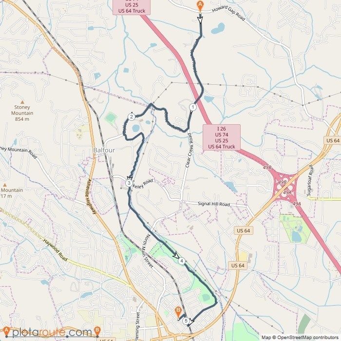
Park. 24LEG #4 - Howard’s Gap 5.73 Miles
Mileage Rating - #7
Difficulty Rating - #5
Start - Bill Moore (Fletcher) Community Park, 85 Howard Gap Rd, Fletcher, NC 28732
Finish - Carter Landscaping, 2834 Clear Creek Rd, Hendersonville, NC 28792
https://www.plotaroute.com/route/482094
Runner Directions
Exit Community Park via the Cane Creek
Greenway
Turn left on Howard Gap Rd (0.4)
Stay straight at roundabout to stay on Howard
Gap Rd (4.2)
Turn right on Clear Creek Rd (5.7)
Transition on right (5.7)
*Number listed is total mileage of leg to that point.
Did you know?
Each leg has an online map (direct link top left
of each leg page) that you can follow by going
to plotaroute.com and searching V2V. Once
you have found your leg, click the map and
then click the arrow to find your location on the
map. This will help those carrying cell phones
on the course who might need directions or re-
assurance.
Driving Directions
Exit Community Park
Turn left on Howard Gap Rd (0.4)
Stay straight at roundabout to stay on Howard
Gap Rd (4.2)
Turn right into Carter Landscaping (5.6)
Transition on East section of property
*Approximate driving time = 11 min
Pro Tips
• This is another easy leg of the course and a majority of your
run will be on Howard Gap Rd.
This Leg Sponsored By:
• Runners should use extra caution and stay to the right after
making the last turn onto Clear Creek Rd as they approach
the transition area.
• Vehicles will turn into Carter Landscaping prior to the Clear
Creek Rd intersection.
25LEG #5 - Hendo 5.15 Miles
Mileage Rating - #10
Difficulty Rating - #12
Start - Carter Landscaping, 2834 Clear Creek Rd, Hendersonville, NC 28792
Finish - Southern Appalachian Brewery, 822 Locust St, Hendersonville, NC 28792
https://www.plotaroute.com/route/482253
Runner Directions
Exit transition on Clear Creek Rd
Turn right on Balfour Rd (1.2)
Turn left to stay on Balfour Rd (1.7)
Turn left to access Oklawaha Greenway (2.2)
Stay straight along greenway next to the creek
Turn right on 7th Ave E (4.5) and stay on right
sidewalk on right side of the road
Turn right on Maple St (4.9)
Turn left on 8th Ave E (5.0)
Transition in road on 8th Ave E (5.1)
*Number listed is total mileage of leg to that point.
*Road will be closed between Maple and Locust St.
Did you know?
The Oklawaha Greenway takes it name from a
Cherokee word meaning “slowly moving muddy
waters” since the trail runs along Mud Creek.
Driving Directions
Exit Carter Landscaping
Turn right on Clear Creek Rd (0.1)
Clear Creek becomes N Main St (2.0)
Turn left on Locust St (3.3)
Park on Locust St (3.3-3.5)
Transition on 8th Ave E next to Southern
Appalachian Brewery
*Approximate driving time = 7 min
*Additional parking located at St. James Episcopal
Church, 766 N. Main St
Pro Tips
• This is rated the easiest leg of the course, with almost half
the route on the flat, mixed use Oklawaha Greenway.
This Leg Sponsored By:
• Runners should not cross the road when exiting the
Greenway onto 7th Ave and should stay on the sidewalk.
• Leg #6 runners will be exiting and running back along 7th
Ave E to the next section of the Oklawaha Greenway. Know
where you are going, don’t just randomly follow another
runner!
• Vehicles may park along Locust St and at St. James Episcopal
Church. 26LEG #6 - The Oklawho? 5.65 Miles
Mileage Rating - #8
Difficulty Rating - #8
Start - Southern Appalachian Brewery, 822 Locust St, Hendersonville, NC 28792
Finish - Hillandale Elementary, 40 Preston Ln, East Flat Rock, NC 28726
https://www.plotaroute.com/route/482254
Runner Directions
Exit transition on 8th Ave E
Immediate left on Locust St
Turn left on 7th Ave E (0.1)
Turn right to access Oklawaha Greenway (0.5)
Turn left on 4th Ave E (1.0)
Turn left on Jackson Park Rd (1.4)
Turn right on Glover St (1.7)
Turn left on Blue Ridge St (1.9)
Turn right on Bradshaw Ave (2.2)
Turn left on Old Spartanburg Rd (2.6)
Turn right on Mt. Airy St (3.5)
Turn left on Spartanburg Hwy (3.8)
Turn right on N Highland Lake Rd (3.9)
Turn left on Highland Lake Dr (4.4)
Turn left on West Blue Ridge Rd (5.3)
Transition on right (5.6)
*Number listed is total mileage of leg to that point.
Driving Directions
Head South on Locust St
Turn right on 7th Ave E (0.1)
Turn left on N Grove St (0.2)
Turn left on Spartanburg Hwy/US 176E (1.4)
Turn right on W Blue Ridge Rd (3.8)
Transition will be on the left (5.0)
*Approximate driving time = 13 min
Pro Tips
• While this leg is not difficult, it has the most turns of any
route on the course for runners. Directionally-challenged
This Leg Sponsored By:
runners beware. Please bring directions with you!
• Runners should run on the sidewalk on 7th Ave E before
using the crosswalk to cross over 7th Ave onto the Oklawaha.
• This leg will have the most vehicular traffic of all the legs.
Please use extra caution. There will be law enforcement
officials to assist runners in crossing Spartanburg Hwy.
• Drivers should use extra caution on Spartanburg Hwy and
around Hillandale Elementary. 27LEG #7 - The Pickler 4.56 Miles
Mileage Rating - #11
Difficulty Rating - #10
Start - Hillandale Elementary, 40 Preston Ln, East Flat Rock, NC 28726
Finish - Tuxedo Park, 1299 Old US Hwy 25, Zirconia, NC 28790
https://www.plotaroute.com/route/482257
Runner Directions
Exit transition heading North East on W Blue
Ridge Rd
Turn right on Roper Rd (0.14)
Immediate right on Mine Gap Rd (0.16)
Turn right on Zirconia Rd (2.5)
Turn left on Greenville Hwy/225 (3.1)
Continue under US Hwy 25 (3.4)
Greenville Hwy becomes Old US Hwy 25 (3.8)
Transition on left (4.5)
*Number listed is total mileage of leg to that point.
*Runners should stay on the right on Roper Rd.
Did you know?
The word Tuxedo is a corruption of an Indian
phrase, tauk suttough, meaning “place of the
bears.” Keep an eye open!
Driving Directions
Exit Hillandale Elementary
Turn right on W Blue Ridge Rd (0.1)
Turn right on Roper Rd (0.2)
Turn right on Spartanburg Hwy/US176 E (1.2)
Turn right on US 25 S (1.7)
Take exit 5 for NC225 (Flat Rock) (3.2)
Turn left on NC 225 S (3.4)
Transition on left at Tuxedo Park (4.7)
*Approximate driving time = 7 min
*Additional parking located at Tuxedo Community
Store, directly across the street from transition.
Pro Tips
• As one of the shortest legs on the route, runners will enjoy
the scenic Mine Gap Rd for a majority of the leg.
This Leg Sponsored By:
• Runners should use extra caution exiting the transition area
on Preston Lane and when turning onto Greenville Hwy and
proceeding under US Hwy 25. There will be race vehicles on
this section of the course.
• Vehicles may park at Tuxedo Park or across the street at
Tuxedo Community Store, home of Green River Picklers.
• This will be one of the busier areas, so vehicles should leave
as soon as possible to get to the next transition. 28LEG #8 - Tali-Ho! 3.53 Miles
Mileage Rating - #12
Difficulty Rating - #6
Start - Tuxedo Park, 1299 Old US Hwy 25, Zirconia, NC 28790
Finish - Talisman Programs Camp, 64 Gap Creek Rd, Zirconia, NC 28790
https://www.plotaroute.com/route/482265
Runner Directions
Exit transition
Head South on Old US Hwy 25
Stay on Old US Hwy 25 the entire route
Transition on right at Talisman Camp (3.5)
*Number listed is total mileage of leg to that point.
Did you know?
Since 1980, Talisman Programs has provided
exceptional camp opportunities for young
people, ages 6 to 22, with autism spectrum
disorders, ADHD and other learning differences.
Learn more by stopping in the camp office or at
www.talismancamps.com.
Driving Directions
Exit Tuxedo Park
Head South on Old US Hwy 25
Stay on Old US Hwy 25 the entire route
Turn right on Gap Creek Rd prior to the transi-
tion zone (3.5)
*Approximate driving time = 6 min
**This is the shortest leg, vehicles should proceed as
soon as possible to Talisman Camp.
Pro Tips
• While this is the shortest leg, runners will spend the last 2.5
miles running uphill to the transition area, which will make
This Leg Sponsored By:
this leg a lot tougher than it looks on paper.
• Runners and vehicles will be traveling the same course for
this leg. Because of the short distance, vehicles should
proceed directly to Talisman Camp so the next runner can be
ready to go; however, please do not speed.
• Talisman Camp is located on the NC/SC Border. Say goodbye
to North Carolina for the day!
• Check out our sponsor, Invert Boardsports, down by the lake! 29LEG #9 - Inverted 6.17 Miles
Mileage Rating - #4
Difficulty Rating - #9
Start - Talisman Programs Camp, 64 Gap Creek Rd, Zirconia, NC 28790
Finish - 1 Callahan Mountain Rd, Travelers Rest, SC 29690
https://www.plotaroute.com/route/482268
Runner Directions
Exit transition
Head South on Old US Hwy 25
Stay on Old US Hwy 25 the entire route
Transition on left at Callahan Mountain Rd in-
tersection (6.1)
*Number listed is total mileage of leg to that point.
Did you know?
In 2011, the Greenville Water System and the
City of Greenville won the “Best of the Best”
Water Taste Test for the entire county. Make
sure you try some at our finish line. Also,
Greenville Water makes some really good beer!
Driving Directions
Exit Talisman Camp
Turn right on Old US Hwy 25 (0.1)
Stay on Old US Hwy 25 the entire route
Turn left on Callahan Mountain Rd prior to the
transition zone (6.2)
*Approximate driving time = 11 min
*Old US Hwy 25 is very curvy, please proceed slowly
down the mountain and cheer the runners on that you
pass.
Pro Tips
• This leg pretty much falls down a mountain. With over 1100’
of elevation drop from start to finish, runners should prepare
This Leg Sponsored By:
their quads and knees before hitting the road.
• Welcome to South Carolina, and what many will argue, is the
most beautiful section of the entire course. Enjoy the scenic
views of the North Saluda Reservoir that provides many
Greenville County residents with fresh, clean drinking water.
• Runners and vehicles will be traveling the same course for
this leg. Please use extra caution turning on Callahan
Mountain Rd near the transition.
30LEG #10 - The Beech 9.84 Miles
Mileage Rating - #1
Difficulty Rating - #4
Start - 1 Callahan Mountain Rd, Travelers Rest, SC 29690
Finish - Beechwood Farms, 204 Bates Bridge Rd, Marietta, SC 29661
https://www.plotaroute.com/route/482270
Runner Directions
Exit transition
Head South on Old US Hwy 25
Turn right on River Rd (1.8)
Stay straight and cross Hwy 11 (4.8)
River Road becomes Hart Cut Rd (4.8)
Turn left on Hannon Rd (7.4)
Turn right on Talley Bridge Rd (8.4)
Turn left on Beechwood Rd (8.5)
Enter Beechwood Farms and turn left on
marked trail (9.0)
Follow dirt trail to the transition located near
the Beechwood Farms market (9.8)
*Number listed is total mileage of leg to that point.
Driving Directions
Exit transition and turn left on Old US Hwy 25
Turn right on River Rd (1.8)
Stay straight and cross Hwy 11 (4.8)
River Road becomes Hart Cut Rd (4.8)
Turn left on US 276/Geer Hwy (8.6)
Turn left on Slater St/State Rd 23-716 (9.7)
Continue on Bates Bridge Rd (10.0)
Transition on left at Beechwood Farms (10.4)
*Approximate driving time = 17 min
Pro Tips
• This is the longest leg of the course and consists of rolling
This Leg Sponsored By:
hills through North Greenville County. The net elevation
drops almost 200’ to continue the SC downhill theme!
• There will be a water refill station about half-way through the
route for runners to refill water bottles.
• Runners and vehicles, use extra caution when crossing Hwy
11.
• Make sure you stop in the Beechwood Farms market to see
what produce the farm has available. Hopefully the
strawberries are in...delicious! 31LEG #11 - The Rabbit 6.20 Miles
Mileage Rating - #3
Difficulty Rating - #3
Start - Beechwood Farms, 204 Bates Bridge Rd, Marietta, SC 29661
Finish - Swamp Rabbit Brewery, 26 S Main St, Travelers Rest, SC 29690
https://www.plotaroute.com/route/482272
Runner Directions
Exit transition at Beechwood Farms
Turn left on Bates Bridge Rd
Turn left on Bates Crossing Rd (0.8)
Turn right on Pleasant Retreat Rd (1.1)
Turn right on White Horse Rd Ext (2.6)
Turn left on Tate Rd (3.8)
Turn right on Swamp Rabbit Trail (3.9)
Stay on Swamp Rabbit Trail until the Center St
intersection (6.1)
Continue straight on sidewalk past Center St to
the Swamp Rabbit Brewery and transition on
left (6.2)
*Number listed is total mileage of leg to that point.
*Follow volunteer and police directions to cross the red
light at Center St.
Driving Directions
Exit transition
Go South on Bates Bridge Rd
Turn right on Bates Crossing Rd/414 (0.8)
Turn left on US 276 S/Geer Hwy (1.8)
Transition on left (5.6)
*Approximate driving time = 10 min
*No parking at the brewery. Parking Options:
TR High School, 301 N Main - 0.6 miles to transition
TR Sargent Library, 17 Center St - 0.3 miles
Gateway Park, 25 Center St - 0.2 miles
TR Family Medicine, 9 McElhaney Rd - 0.1 miles
TR United Methodist, 19 S Main St - 0.1 miles
Pro Tips
• This farm-to-brewery 10K would be a classic run all by itself. This Leg Sponsored By:
Back country roads lead to the popular Swamp Rabbit Trail
and into downtown Travelers Rest. Check out the many shops
in TR before, during, or after the race!
• Downtown Travelers Rest is very popular on Saturday
afternoons and there will be no parking at the brewery. We
have multiple parking options that include TR High School, TR
United Methodist Church, TR Family Medicine, Gateway Park
and TR Sargent Library. Do not park at Anytime Fitness or
you may be towed.
32You can also read