A Jessop Trail The Cromford Canal and Cromford & High Peak Railway
←
→
Page content transcription
If your browser does not render page correctly, please read the page content below
A Jessop Trail
The Cromford Canal and
Cromford & High Peak Railway
Part 2: High Peak Trail

                              EXPLORE
                          ENGINEERING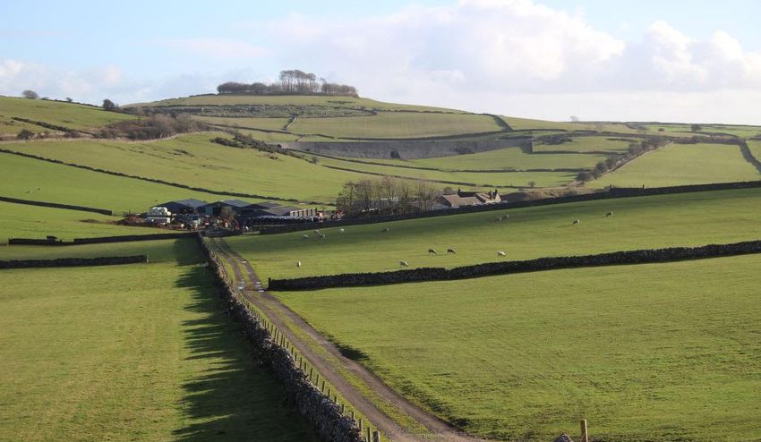
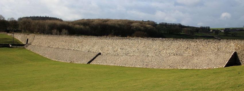
Introduction
The civil engineers William Jessop (1745-1814) and his son Josias (1781-1826) left their
marks on the Derbyshire Peak District with a remarkable canal and railway, which fitted
well into the landscape and can still be followed by anyone with a car or bicycle.

This route is too long for walking in one day (if returning the same way), though
there are car parks at both ends and along the route which provide options to explore
shorter sections. Cycle hire facilities also exist at Middleton Top and Parsley Hay, though
opening is seasonal. There are also several inclines (uphill from High Peak Junction
to Parsley Hay, downhill if route followed in reverse); cyclists are advised to dismount
when travelling downhill.

Cromford & High Peak Railway (C&HPR)
Before the Stockton & Darlington Railway was opened in 1825, a proposal was made
to build a railway to connect William Jessop’s Cromford Canal with Benjamin Outram’s
Peak Forest Canal at Whaley Bridge, 33 miles to the north-west. It was designed by
William’s son Josias. He died suddenly in 1826, just after construction work had begun,
but the work was completed to his design and the railway was opened throughout in
1831.

It was a standard-gauge railway, mostly double-tracked, but designed on canal
principles, with long, almost level stretches connected by short, steep inclines. Starting
from High Peak Junction on the Cromford Canal (at 278ft above sea level), the line rose
via 5 inclines to a summit level of 1266ft, and then descended via 4 inclines to 517ft at
Whaley Bridge.

In order to maintain a reasonably level alignment between the inclines, when passing
over undulating natural ground, cuttings and embankments were built. Bridges
took the railway over roads or tracks (and vice versa), and some short tunnels were
constructed. The most fascinating structures are the stone embankments (limestone
being plentiful nearby), which provide dramatic statements of early 19th century civil
engineering confidence, especially near Minninglow.

View from location 5, looking SE towards Minninglow Hill

Stationary steam-driven winding engines at the top of the inclines raised and lowered
wagons (those descending acting as a counterweight for those ascending) hauled
on ‘endless’ cables running via a series of pulleys between the rails. At the bottom
of the inclines a wheel pit contained the mechanism for returning the cable, and for
maintaining the correct tension as the length varied according to temperature.

Horses originally pulled the wagons on the level stretches, but from 1833 were
gradually replaced by steam locomotives, a process that took several decades. Goods
such as coal and limestone were transported, and passengers were carried until 1876.
The southern part of the line remained in operation until 1967, but many quarries still
exist near to the route of the line, and now use road haulage.
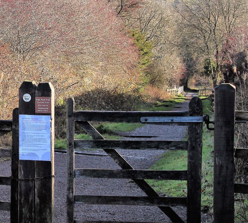
1     High Peak Junction
High Peak Junction car park is 1.5 miles SE of Cromford on the road to Holloway, and
provides access to High Peak Junction via footbridges over the river, railway and canal.
The old railway workshop buildings, believed to be the second oldest in the world, now
house a shop and a museum.

The railway met the Cromford Canal at High Peak Junction, at the bottom of Sheep
Pasture incline, where part of the cable winding mechanism has been restored. Further
on, and just beyond the bridge that takes the A6 over the old rail route, there is a catch
pit for runaway wagons.

 2     Black Rocks
Car parking and public conveniences are available. There are bus services between
Matlock, Cromford and Wirksworth, passing nearby.

This location takes its name from the dark gritstone rocks that outcrop here and were
used to make millstones, though they overlie limestone which was quarried nearby until
recently. The site was occupied by Cromford Moor Mine, which had a shaft over 400 feet
deep, and was a source of lead ore (galena) plus other minerals.

Heading west towards the foot of Middleton Incline, the trail passes by the Steeple
Grange Light Railway, and then the National Stone Centre where parking is also available.

Wirksworth’s first railway Station was at Steeplehouse on the C&HPR; the site is now
occupied by the Steeple Grange Light Railway (SGLR). This 18’’ gauge line (450mm) is on
the trackbed of the former Killers branch, named after the Killer brothers who owned
and operated Middleton Quarry, though the original line was built to standard gauge
(1435mm). This quarry produced stone used for the Imperial (now Commonwealth) War
Graves Commission after the First World War, and there is a commemorative headstone
nearby. Another branch into Steeplehouse Quarry was opened in 1900, principally as a
source of ornamental and building stone; this produced ‘black’ limestone, which contains
fossilised shark teeth.

Near the National Stone Centre, information boards describe some of the other quarries
in the vicinity as well as the wheel pit at the foot of the Middleton Incline.

 3     Middleton Top Engine House
Car parking, cycle hire and public conveniences are available.
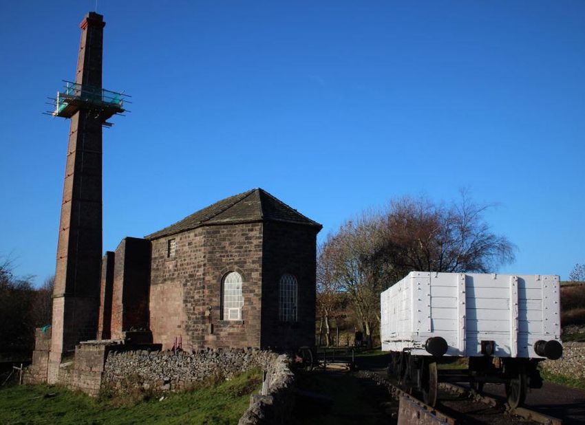
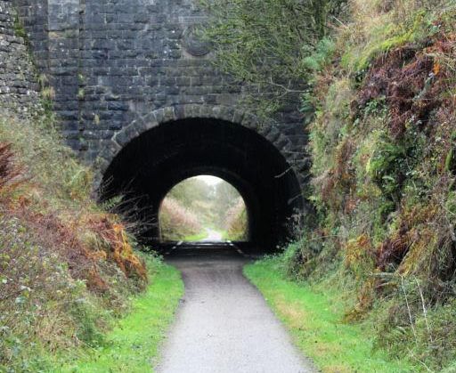
This is the sole surviving engine house of those that once stood at the top of every
incline. It is scheduled as an Ancient Monument, together with its Butterley beam
engine of 1829 that used to wind the haulage cables up the 1 in 8.75 Middleton
Incline. The engine has been restored, but the boilers have not, so it is now run
occasionally on compressed air. (Refer to Derbyshire County Council website for
Operating Days or telephone 01629 533298).

Follow the old railway track 0.75 miles westwards in order to view Hopton Tunnel.

 4     Hopton Tunnel & Incline
A short but impressive tunnel approached through a rock cutting. Passing through
the tunnel, the trail runs onto embankment before Hopton Incline is reached.

The Hopton Incline became the steepest gradient (1 in 14) on a standard-gauge
railway in Britain worked by unassisted locomotives, after its winding engine failed in
1877. The engine was never replaced.

 5     Minninglow
Use the Peak District National Park car park near Pikehall. The larger Minninglow
embankment is next to the car park, travelling eastwards, and the other one is ¾
mile further along the railway track, now heading southwards after a sharp curve.

The two embankments are striking, being faced with limestone on both sides. The
larger is 300yds long and over 30ft high in the centre, standing like a reservoir dam
or castle wall.

 6     Parsley Hay and Newhaven Tunnel
Parsley Hay car park is just off the A515 Buxton to Ashbourne road and contains toilets
and bike hire (seasonal). Walk southwards along the railway track for about ½ mile to
the Newhaven Tunnel with its commemorative stone. (Keep left at what was Parsley
Hay Junction on the railway; the branch to the right, which goes through a deep rock
cutting, is the track of the later line from Ashbourne, now called the Tissington Trail).

The tunnel under the Buxton to Ashbourne road has a commemorative plaque
showing the name of the railway’s engineer, Josias Jessop, on the portal at its north
end, as well as a decorative stone dated 1825 with the inscription ‘Cromford & High
Peak Railway Company’ ; there is a similar one on the south portal.
A515 TO BUXTON
        PARSLEY
          HAY
                                                                                     KEY:
                                                                                            TRAIL                                    A6
                                                                                                                                TO BAKEWELL
                        54
                  B50                     FRIDEN
                                                                                     WINSTER                                       MATLOCK
HARTINGTON                   HEATHCOTE                                                                                                            A615
                                                                                                         BRIGHTGATE
                                                   PIKEHALL
                                                                                                                                              RIBER

                                                                                       B50
                                                                           A501
                                                                                 2                                    BONSALL
                                 BIGGIN

                                                                                        56
                                                          MINNINGLOW
                                                             HILL                           GRANGEMILL                   MATLOCK
                                                                                                                          BATH
                                                                       ALDWARK
                                                                                                    VIA GELLIA
                                                                                                                      CROMFORD                           HOLLOWAY
                 A515
             TO ASHBOURNE
                                                                                                                                       BOLEHILL
                                                                                                                 WIRKSWORTH
                                                                                                                                                                    A6 TO DERBY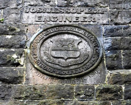
Approximate          Approximate
                              Map              distance along       height
 Location
                              Reference        route in miles       difference in
                                               (kms)                feet (m)

 High Peak Junction (P)       315 561          0

 Black Rocks (P)              292 557          1.5 (2.4)            485 (150)

 Middleton Top (P)            276 552          2.6 (4.2)            250 (75)

 Top of Hopton Incline        252 547          4.9 (7.9)            105 (30)

 Minninglow - Pikehall (F)    195 582          9.0 (14.5)

 Friden (F)                   172 607          11.4 (18.3)

 Parsley Hay (P)              147 637          14 (22.5)

Map references refer to Ordnance Survey Landranger 119 or OL 24 (grid ref SK)
P = Pay Car Park; F = Free Car Park (2019)

Original text by John Gardiner, 1995; updated and photographs taken by Robert Armitage,
FICE, 2018. For further reading: Barton B, Civil Engineering Heritage – East Midlands,
Ruddocks Publishing Ltd, Lincoln, 2016. ISBN 978 0 904327 24 3.

Institution of Civil Engineers
One Great George Street
Westminster
London SW1P 3AA
UK

E: ice.eastmidlands@ice.org.uk
W: ice.org.uk

Institution of Civil Engineers is a Registered
Charity in England & Wales (no 210252) and
Scotland (SC038629).

                @ICE_EastMids
You can also read