A local oral history of environmental change in Pelorus / Te Hoiere, Marlborough - LEAP Research Report Preliminary report for the Department of ...
←
→
Page content transcription
If your browser does not render page correctly, please read the page content below
LEAP Research Report
No. 47

A local oral history of
environmental change in
Pelorus / Te Hoiere, Marlborough
Preliminary report for the Department of
Conservation

Gemma L. Coutts
Stephen C. Urlich

July 2020
Cover photo: Looking towards the mouth of Pelorus River from Havelock. Photo: G. Coutts,
January 2020.
A local oral history of environmental change in Pelorus / Te Hoiere, Marlborough

A local oral history of Environmental Change
    in Pelorus / Te Hoiere, Marlborough
Preliminary Report for the Department of Conservation

Land Environment and People Research Report No. 47
                      2020

             ISSN 1172-0859 (Print)
             ISSN 1172-0891 (PDF)
          ISBN 978-0-86476-441-6 (Print)
          ISBN 978-0-86476-442-3 (PDF)

    Lincoln University, Canterbury, New Zealand

                                                                                              i
A local oral history of environmental change in Pelorus / Te Hoiere, Marlborough
Contents
Summary .............................................................................................................................. iii
Chapter 1. Introduction....................................................................................................... 1
Chapter 2. Methods ........................................................................................................... 3
Study area ............................................................................................... 3
Climate and Rainfall ................................................................................ 6
Geology and soils .................................................................................... 7
Semi-structured interviews ...................................................................... 7
Chapter 3. Historical Context ............................................................................................. 9
Chapter 4. The stories...................................................................................................... 11
Chapter 5. Shifting baselines ........................................................................................... 16
Chapter 6. Looking to the future ....................................................................................... 17
Acknowledgements ............................................................................................................. 18
Appendix ............................................................................................................................. 19
References ......................................................................................................................... 20
List of Figures
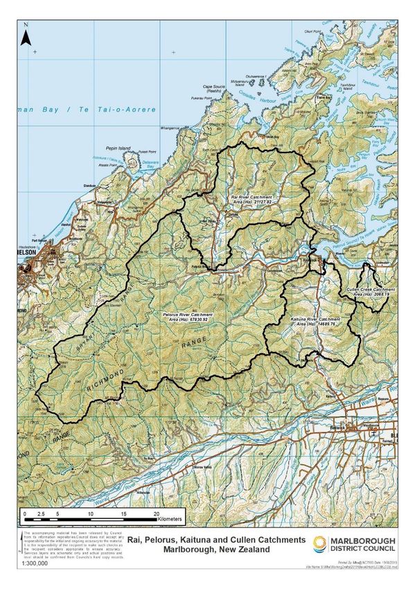
Figure 1: Map of Rai, Pelorus/Te Hoiere, Kaituna and Cullen catchments. The Pelorus/Te
Hoiere includes the Rai and Whakamarino (Wakamarina) catchments. .............. 3
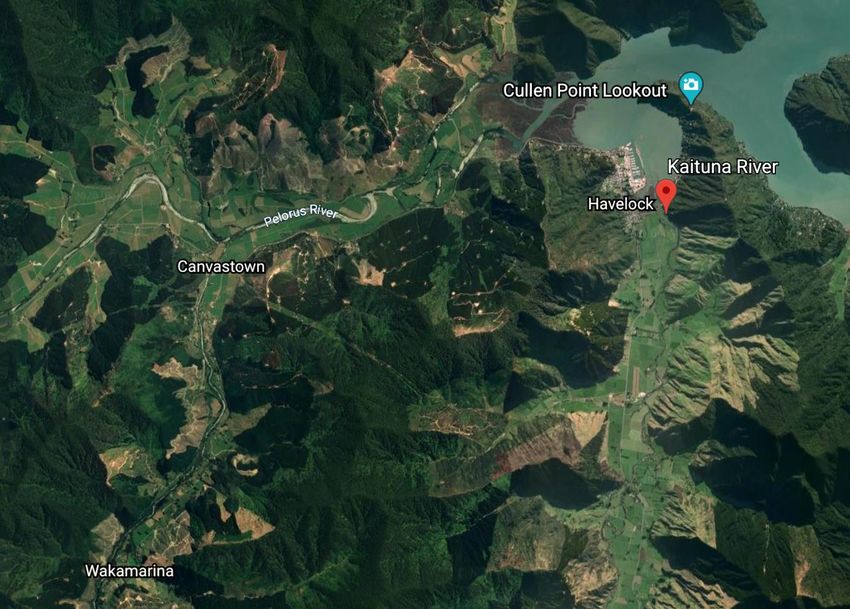
Figure 2: Image of the Kaituna catchment as well as Canvastown (the Whakamarino
(Wakamarina) catchment is behind Canvastown) which discharges into the
Havelock estuary. Image sourced from Google Earth, February 2020. ............... 4
Figure 3: This photo was taken on the Te Araroa trail, looking down the Pelorus/Te Hoiere
river (facing east). ............................................................................................... 5
Figure 4: Mean annual rainfall for the period 1981-2010. Modified from Figure 3 in Tait
2017. .................................................................................................................. 6
Figure 5: Native timber clearing in Pelorus – note the hills have been cleared as well. The
small cottage looks south across the Pelorus River. Image taken circa 1900-
1910. ................................................................................................................ 10
List of Plates
Plate 1: Looking down Rai Valley from the Mt Richmond ranges, behind Pelorus Bridge café.
Photo G. Coutts, January 2020. ..........................................................................iv
Plate 2: Looking upstream the Pelorus/Te Hoiere River emerges from the Mt Richmond
range, behind Pelorus Bridge café. Photo G. Coutts, January 2020. ...................iv
List of Tables
Table 1: Present-day catchment land use ............................................................................ 5
ii
A local oral history of environmental change in Pelorus / Te Hoiere, Marlborough

                                   Summary
The Pelorus/Te Hoiere was announced as an ‘Exemplar catchment’ for the purposes of
restoration, by the Minister of Conservation in late 2019. The catchment restoration project is
to be managed by the Kotahitanga mō te Taiao Alliance (the ‘Kotahitanga Alliance’) as a
partnership with the local community. The Kotahitanga Alliance was formed to
collaboratively address issues of environmental concern across the top of the South
Island/Te Tau Ihu. Ngāti Kuia, Marlborough District Council (MDC), and the Department of
Conservation (DoC), have come together to achieve environmental, social, cultural and
economic improvements for Pelorus/Te Hoiere, by involving communities and building
partnerships across the catchment.

As part of the overarching project, the Kotahitanga Alliance wants to start to understand
people’s memories of environmental change – acknowledging and recording these stories
will aid the Kotahitanga Alliance in developing a collaborative landscape catchment program.
Biophysical science along with local histories have identified significant changes to terrestrial
and estuarine ecosystems since European settlement. However, it is not known whether
those changes, particularly in more recent years, are evident in lived experiences. The
socio-ecological ‘shifting baselines’ phenomenon occurs where gradual environmental
degradation gets progressively accepted as each generation experiences their place. This is
important to understand, so as to help inform community discussions about the need for
restoration goals.

This research is a pilot study of 10 interviewees from the wider Pelorus/Te Hoiere catchment
conducted in January 2020, to get insights into the nature of shifting baselines. The purpose
of this preliminary report is to describe the catchment setting, outline the methodology and
provide some initial insights from the interviews, which suggest that there are contrasting
beliefs about the health of the river and estuary. A detailed analysis of the interviews is
planned as part of a Master of Applied Science thesis at Lincoln University in 2021, and
additional interviews may be undertaken over the next 12 months to achieve that goal.

                                                                                                          iii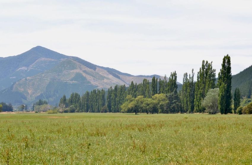
A local oral history of environmental change in Pelorus / Te Hoiere, Marlborough

Plate 1: Looking down Rai Valley from the Mt Richmond ranges, behind Pelorus Bridge café.
                              Photo G. Coutts, January 2020.

  Plate 2: Looking upstream the Pelorus/Te Hoiere River emerges from the Mt Richmond
            range, behind Pelorus Bridge café. Photo G. Coutts, January 2020.

                                                                                                       iv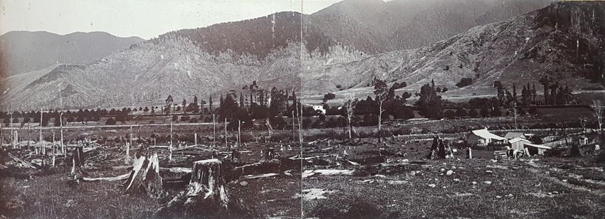
A local oral history of environmental change in Pelorus / Te Hoiere, Marlborough

                                     Introduction
In 2019 the New Zealand government published Environment Aotearoa, a report that is
required under the Environment Reporting Act 2015 to establish the current state of the
environment in Aotearoa New Zealand (Ministry for the Environment and Stats NZ, 2019)1.
The 2019 report uses five main themes to identify nine priority environmental issues;
including biodiversity loss, land use, pollution, marine and freshwater use and climate
change.

One of the issues identified in the report is unsustainable land use practices, which are
causing adverse effects on waterways and coastal ecosystems. Clearing native vegetation
for farming or forestry blocks can increase the chances of erosion and sedimentation being
deposited into the coastal marine area, while expanding towns and cities and draining
wetlands can also increase erosion and soil loss. These activities can negatively affect
native species and their habitats, which can also reduce cultural values.

Effects from land cover changes have also been identified as an environmental issue of
concern in the Marlborough region (MDC 2015). The natural climate and geology in
combination with suboptimal land management practices, can result in adverse effects on
the freshwater and estuary receiving environments. MDC has identified the following
adverse effects: increased chances of steep-slope erosion; debris flows, fine silt and clay
sediments degrading freshwater quality, and smothering intertidal and subtidal habitats in
the Marlborough Sounds (‘Sounds’).

These cumulative effects have also had a negative impact on cultural values for local iwi to
observe mahinga kai and other tikanga (Waitangi Tribunal, 2008). The Kotahitanga mō te
Taiao Alliance (‘Kotahitanga Alliance’) was established to address increasing environmental
issues across the top of the South Island region. In 2019, the Kotahitanga Alliance released
their strategy and vision, which aims to achieve significant cultural, social, environmental
and economic gains, as well as specific outcomes for each region (Kotahitanga Alliance,
2019).

The Kotahitanga Alliance members directly concerned with the Pelorus River/Te Hoiere in
Marlborough – Ngāti Kuia, Marlborough District Council and the Department of
Conservation, stated in the Kotahitanga mō te Taiao Strategy that one of their aims is to
restore the mauri (’life essence’) to the Pelorus River/Te Hoiere and other tributaries. This is
to be achieved by managing ki uta ki tai – from the mountains to the sea. This means
considering the catchment as an interconnected system, rather than focusing on separate
components.

The Government also recognised this in the draft National Policy Statement for Freshwater
Management (NPS-FW), issued for consultation in September 2019 (Ministry for the
Environment (MfE), 2019). The draft NPS-FW states that integrated management must
“recognise the interactions ki uta ki tai between freshwater, land, waterbodies, freshwater
ecosystems, other ecosystems and sensitive receiving environments, including the coastal
environment” (MfE, 2019).

1 The last full report on the state of the environment was released in 2015, and before that, different versions
were released in 2007 and 1997. By using available data, these reports are only intended to establish the current
state of the environment, rather than provide comments on how to address those issues. This style of reporting
aims to encourage discussion around Aotearoa environmental issues.

                                                                                                                1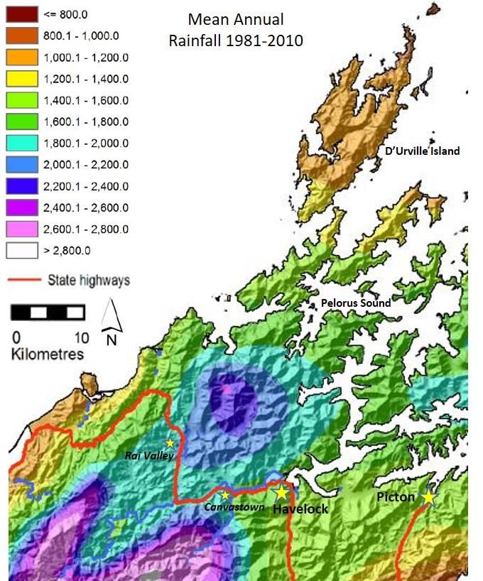
A local oral history of environmental change in Pelorus / Te Hoiere, Marlborough

Due to the state of the Pelorus/Te Hoiere River and estuary environment from excessive
sediment deposition derived from the surrounding land, the Minister of Conservation
announced Pelorus/Te Hoiere is to be an ‘Exemplar catchment’ (RNZ, 2019; Stuff, 2019).
The ‘Exemplar catchment’ project is part of the Government’s ‘At Risk’ catchment
programme – where catchments across New Zealand are identified as vulnerable under the
Government’s Essential Freshwater work programme2. This announcement allows for
specific allocation of government funding to the Pelorus/Te Hoiere catchment, to implement
a bottom-up, collaborative strategy to help improve the health of the river and estuary (MfE,
2018).

However, due to possible “shifting baseline syndrome” (Pauly, 1995) – where the next
generation assume the degraded environment is normal, and therefore it’s diminished state
is accepted – some in the community may find this announcement difficult to acknowledge
and understand (Robertson et al. 2000; Soga & Gaston, 2018; Williams & Riley 2018).
Conducting historical social research can help to contextualise the shifting baseline concept
for local communities, but it also creates a human dimension to an ecological history (Lane,
1997; Williams & Riley, 2018). Interviewing local residents, who have a personal, long-
standing connection to the area, is one way to explore a human dimension to the
environmental history. Scientific data and personal interviews, in addition to historical
documents and photographs can help contribute to a history of the region – which in turn,
could also aid in lifting baselines by supporting restoration efforts (Robertson et al. 2000).

In this regard, this research aims to capture some of those personal stories by interviewing
some local residents in the Pelorus/Te Hoiere catchment. This is a pilot project, done as a
summer research scholarship supported by Lincoln University and the Kotahitanga Alliance.
It informs part of the Kotahitanga Alliance’s plan for community engagement associated with
the development of an overall restoration management plan for the catchment. As part of the
‘Exemplar catchment’ status, the Kotahitanga Alliance aims to help achieve cultural, social,
environmental, and economic outcomes that benefit all communities in the catchment. This
will be accomplished by developing an integrated catchment management plan for the
Pelorus/Te Hoiere catchment – one that involves the community from the outset.

2 The Essential Freshwater work programme is the Government’s plan to restore and protect Aotearoa New
Zealand’s freshwater. This programme includes: introducing a new National Environmental Standard and
amended National Policy Statement for Freshwater; catchment-level action; an independent review on nutrient
tracking technology; and establishing advisory groups for the Essential Freshwater programme (MfE, 2020).

                                                                                                              2
A local oral history of environmental change in Pelorus / Te Hoiere, Marlborough

                                    Methods
       Study area
The Pelorus/Te Hoiere catchment lies between Blenheim and Nelson, in the northern part of
Marlborough (Figure 1). The catchment extends over approximately 889 km2 or 88,959
hectares (ha) and includes the Rai and Whakamarino (previously Wakamarina) catchments.
The Pelorus/Te Hoiere discharges into the Havelock estuary and Pelorus Sound/Te Hoiere.
Both rivers drain the northern side of the Richmond Ranges.

 Figure 1: Map of Rai, Pelorus/Te Hoiere, Kaituna and Cullen catchments. The Pelorus/Te
           Hoiere includes the Rai and Whakamarino (Wakamarina) catchments.
                      Image courtesy of Marlborough District Council.

                                                                                                        3
A local oral history of environmental change in Pelorus / Te Hoiere, Marlborough
The Rai River covers over 211 km (21,127 ha) as it drains the eastern side of the
Whangamoa Range, and the southern side of the dividing hills which separate Croisilles
Harbour and Tennyson Inlet. The many creeks and streams flowing from these hills and
valleys combine to form the Brown, Tunakino, Ronga, and Opouri rivers, which progressively
merge to form the Rai just to the north of Rai township.
There are a few small towns situated throughout these catchments – Havelock, which sits
right on the mouth of the river, Canvastown, Wakamarina Valley and Rai Valley. The Kaituna
River catchment also discharges into the Havelock estuary (Figure 2). It encompasses 146.9
km2 (14,690 ha). On the true left, it drains the north-eastern side of Mt Riley in the Richmond
Range; on the true right, it is fed by waterways from a range running south to north which
gradually steepen to the high point of Mt Cullen. Although also not included in this study, the
20.7 km2 (2068 ha) Cullen Creek catchment also influences the inflow of silt and nutrients
into the Havelock estuary complex, which includes the Mahakipaoa and Kaiuma estuaries.
Figure 2: Image of the Kaituna catchment as well as Canvastown (the Whakamarino
(Wakamarina) catchment is behind Canvastown) which discharges into the Havelock
estuary. Image sourced from Google Earth, February 2020.
Indigenous forests dominated by beech (Lophonzia menziesii and Fuscospora spp.) extend
over much of the steeplands and montane areas of Pelorus/Te Hoiere (Table 1). Exotic
forest mostly comprised of radiata pine (Pinus radiata) is the next largest single land use,
followed by dairy pasture on the relatively fertile valley floors (Figure 3).
One of the iconic sites in the Pelorus/Te Hoiere catchment is the Pelorus Bridge Scenic
Reserve. It features 856 ha of unlogged old-growth lowland alluvial and gentle slope forest
and is one of the last remaining forests of its type in Marlborough. The reserve contains a
variety of beech, podocarp and broadleaf tree species. Black and hard beech can be found
on drier spurs, ridges and older terrace surfaces; while rimu, miro, mataī, tōtara and
4A local oral history of environmental change in Pelorus / Te Hoiere, Marlborough
kahikatea trees tower over broadleaf, tawa, kamahi and hīnau on more fertile, recent
terraces and wetter gully systems. On the lower parts of the forest floor is a mixture of
liverworts, mosses, shrubs, saplings and ferns (Department of Conservation, n.d.; Ward,
1987).
Table 1: Present-day catchment land use
Land use Pelorus
(Area, km2)
Indigenous Forest 639.6
Broadleaved Indigenous Hardwoods 29.3
Manuka and/or Kanuka 11.2
Exotic Forest 91.4
Forest - Harvested 15.7
High-producing exotic grassland 75.7
Low-producing exotic grassland 4.2
Gorse and/or Broom 8.3
Fernland 0.8
Orchard/perennial cropsA local oral history of environmental change in Pelorus / Te Hoiere, Marlborough
Climate and Rainfall
Annual average rainfall varies in a north-south gradient (Figure 4). In the northern parts of
D’Urville Island and outer Pelorus Sound/Te Hoiere it ranges from 1000-1200 mm. Rainfall
in excess of 2000 mm occurs in the Bryant Range northeast of Rai Valley, and on the
Richmond Ranges to the south of Rai Valley and Canvastown (Tait, 2017) (Figure 4).
MDC have records of high intensity rainfall events since 1979 in the Pelorus catchment.
There are also historical records that describe the Pelorus River/Te Hoiere flooding, and
washing out the Pelorus Bridge. A major flood washed out the Pelorus Bridge in 1904
(Marlborough Express, 1904; Ward, 1987).
Figure 4: Mean annual rainfall for the period 1981-2010. Modified from Figure 3 in Tait 2017.
6A local oral history of environmental change in Pelorus / Te Hoiere, Marlborough
Geology and soils
The parent rocks that comprise the headwaters of the rivers are predominantly composed of
Mesozoic siliceous greywackes and schists, with bands of serpentinite greywacke (Walls &
Laffan, 1986). The rock type has been described as the Haast or Marlborough Schist Group,
which are aligned in bands to the northeast. Weathering of weaker mineral bands in the
schist produces planes of weakness prone to deep and surficial slippage with sediment
detritus of characteristically flat (platy) form. Overlying the schist is a layer of hardened
sandstones and siltstones as greywacke and argillite atop the Pelorus Group (Lauder,
1987).
Within the Pelorus/Te Hoiere catchment, soils are broadly classified into four main soil
families: Ronga, Rai, Pelorus and Opouri series (NZ Soil Bureau, 1968; Gray, 2012). The
Ronga, Rai, and Pelorus lowland soils are found on river terraces and lower undulating
slopes, and are under pasture with dairying the predominant land use (Gray, 2012). These
relatively productive soils have sustained pastoralism for over a century following clearance
of river terrace and hillslope forests (Paton, 1982; Walls & Laffan, 1986) (Table 1). Soil
mapping in the catchments is generally at a coarse scale (1:250,000) from the 1960s (NZ
Soil Bureau, 1968). MDC have been undertaking more fine-scale soil mapping in the
Pelorus/Te Hoiere (Gray, 2012; Matt Oliver, MDC, personal communication, 2019).
Semi-structured interviews
A semi-structured interview process, (characterised by guiding questions but not yes or no
questions), was chosen as it allows for conversations to organically develop and information
is not ‘sought out’ by the interviewer (Maxwell & MacDiarmid, 2016). The interviews were
directed by four set questions (shown in Appendix 1). As the conversation developed this
still permitted the interviewer to ask more specific questions that related to the particular
participant they were interviewing.
Twenty-four participants were nominated by the Kotahitanga Alliance, or suggested by
interviewees on a ‘snowball’ basis. Some have long-standing generational connections in
the area, while others have first- or second-generation connections to Pelorus/Te Hoiere.
The list of possible participants came from a range of backgrounds and industries –
including farming, forestry, conservation, and tourism. Eleven of the 24 nominees are Ngāti
Kuia members. Contact was kept with Ngāti Kuia throughout the research to date; however,
members were unable to interviewed before this report was prepared, because of different
schedules in January and planned interviews in April were unable to be conducted due to
COVID-19. Ngāti Kuia members will be interviewed in the next phase, circumstances
permitting.
Ethics approval was granted by Lincoln University on 16 December 2019, under application
number 2019-89. Participants were then contacted either through phone or email, depending
on what details were provided by the Kotahitanga Alliance. A list of twenty-four possible
participants were provided, and three more participants were added to the list, through
recommendations from other participants. Of the twenty-seven participants, six people were
not able to participate, in addition to the 11 iwi members. The researcher was able to
interview ten people, both in person and through an emailed questionnaire format, which
was provided when participants were not available to be interviewed in person. Further
interviews are planned to be conducted over the coming summer months.
7A local oral history of environmental change in Pelorus / Te Hoiere, Marlborough
The researcher asked four main questions (detailed in Appendix 1). The first question was to
establish the participant’s connection to Pelorus/Te Hoiere, and why the area is special to
them. Question 2 was about environmental changes they had noticed over time, learning
and understanding local ecological knowledge. The third question focused on what aspects
of Te Hoiere/ Pelorus were special to them to either maintain or improve. Question 4 was
asked to discuss interviewee aspirations for the area, and what ideas they had for
Pelorus/Te Hoiere to make it a more healthy and thriving catchment.
The participant’s interviews were recorded by the researcher and transcribed into a
Microsoft Word document. However due to time constraints, the accounts were not
transcribed verbatim, but listened back to by the researcher and the main points extracted,
with direct quotes and time stamps added as references and for accuracy.. General themes
were drawn from the transcripts, analysed, and some are discussed in the following
sections. The recorded interviews are stored at Lincoln University as per the Human Ethics
Committee guidelines.
8A local oral history of environmental change in Pelorus / Te Hoiere, Marlborough
Historical Context
Māori settlement
Due to their longstanding history to the area, as well as their whakapapa lineage to Maui,
Kupe and Matua Hautere, Ngāti Kuia are the tangata whenua of Te Hoiere, and are also one
of the oldest iwi in the Te Tau Ihu rohe (Ngāti Kuia, 2015). Matua Hautere was guided to Te
Hoiere by the taniwha Kaikaiāwaro and his successors settled the land. Eventually they
migrated to Te Hoiere, which they named after his waka (Ngāti Kuia, 2015).
Māori tended to live in kainga or fortified pā, settling in areas that were abundant in food and
water supply – like rivers, estuaries, lakes, forests or coastal areas. Estuaries, wetlands and
forests provided plants and birds for food, medicines and weaving, while waterbodies
provided an array of kai ika, tuna and kaimoana (Mitchell & Mitchell, 2007; Waitangi
Tribunal, 2008). In particular, Ngāti Kuia utilised the Kaituna and Pelorus/Te Hoiere to gather
and provide food – especially kaimoana, tuna and seabirds (Ngāti Kuia, 2015).
Archaeological discoveries of food-storage pits, middens, ovens, cultivated areas and
artefacts reflect long-term indigenous settlements throughout Pelorus Sound/Te Hoiere
(Waitangi Tribunal, 2008). Māori also cleared small areas of land for animal farming to
cultivate and harvest vegetables (Waitangi Tribunal, 2008).
European settlement
Following the European settlement of Nelson starting in 1842, European settlers made their
way over to Pelorus/Te Hoiere via the Māori-formed route over the Maungatapu Saddle.
This route was eventually developed into a bridle track and travellers going between
Blenheim and Nelson used the route extensively (Hale, 1960). Some of the first Europeans
settlers constructed accommodation houses that allowed tired travellers to stay overnight in
the Pelorus, as it took two days to travel between Nelson and Blenheim (Hale, 1960; Ward,
1987).
The discovery of gold in 1864 resulted in floods of prospective miners flocking to the Pelorus
Valley who set up tents in the Wakamarina Valley, Canvastown and Havelock (Stephens,
2009). The frenzy in the Whakamarino Valley lasted a year, before people moved onto the
next mining region, which left the valley in degraded state, as reported in the Havelock Mail,
1865 (Brayshaw, 1964, p. 21): “It cannot be concealed that the thousands who visited us in
the last eight months have left the province altogether... A great deal of damage has been
done to the flumes, sluice boxes and other gear required by miners, which may be seen
going down the Pelorus in flood waters.”
Figure 5 illustrates that native timber milling was another economic activity in the late
nineteenth century. William and Christina Brownlee arrived in Marlborough in 1864 with their
family, bringing sawmilling machinery from Scotland, and very likely planning to provide the
goldminers with timber (Stephens, 2008). From 1864 to 1915, Brownlee and Co. milled and
exported an estimated 189 million feet of native timber – mainly from the Pelorus and Rai
valley floors (Hale, 1960; Stephens, 2008). Land clearance utilising uncontrolled burning
9A local oral history of environmental change in Pelorus / Te Hoiere, Marlborough
was also a common practice at this time to make open spaces for agriculture (Bowie, 1963).
The native forest still found today at Pelorus Bridge was spared from clear felling and
burning during this time, as the land was put aside for a township. However, in 1906 that
idea was abandoned, and in 1912, the lowland forest was announced as a scenic reserve
(Ward, 1987).
Figure 5: Native timber clearing in Pelorus – note the hills have been cleared as well. The
small cottage looks south across the Pelorus River. Image taken circa 1900-1910.
Image courtesy of the Couper family.
Farming in the Pelorus, Rai and Wakamarina valleys soon followed timber milling, with
European settlers obtaining land soon after it had been cleared of native timber. European
land ownership began as early as the 1880s, with families purchasing land on which to
establish dairy, beef and sheep farms. In 1913 the Marlborough Express reported: "...in no
district has this growth been more rapid than the Rai Valley. Here the fast disappearing bush
is giving place to fertile grazing areas...” (Marlborough Express, 1913; Stephens, 2013)
However, in the early twentieth century, Marlborough was suffering from a timber shortage –
indigenous timber prices rose, and people could not afford to build. It was widely
encouraged for local people to plant radiata pine on their ‘waste’ land (Marlborough Express,
1920a, 1920b). The first commercial radiata plantation was planted in 1940 in the Pelorus
catchment and harvesting began in the late 1970s/early 1980s. Many of the current
plantations in the area are into their second rotation (Urlich & Handley, 2020). For a history
of radiata pine forestry, see Urlich and Handley (2020).
10A local oral history of environmental change in Pelorus / Te Hoiere, Marlborough
The stories
Question 1: Tell me about your connection to Pelorus/Te Hoiere
This first question established the interviewee’s connection to Pelorus/Te Hoiere. Prompts
that the researcher asked included: Where are you from? What are some of your earliest
memories? Why is this place important to you? Asking these questions also helped to
establish a relationship between the researcher and the participant as well as determining
the participant’s personal attachment towards Pelorus/Te Hoiere.
Essentially, all participants answered in the same way. Some spoke about their long-
standing family connections to the land, where others spoke of the resources the river and
Sounds have – “It has everything.”
Interviewees who have long-standing ties to the catchment, discussed their family history
and what their predecessors had achieved in the area. Some incredible physical feats were
achieved in those times. As one participant mentioned:
“Those days [late 1800s] were hard times, people had to work to make a living... You had
animals but you couldn’t afford to kill them to eat them.”
Many of the anecdotal stories were told with fondness and sentiment, demonstrating that
above all else, the interviewees see Pelorus/Te Hoiere as a beautiful catchment that
provides its residents with everything that they need:
“I remember as a kid we would always come out to Pelorus almost every weekend, with my
parents in the summer. It’s really nostalgic for me... I just love it here. Never gets old.”
All of the participants spoke about the recreational activities available in the area –
swimming, hunting, fishing, walking, kayaking, sailing, as well as the community support
from other locals in times when support is needed. It is clear from the participant’s answers
that the area is special to them, in many different ways. Connections to Pelorus/Te Hoiere
are for some, primarily through a generational connection, while others connect to the
landscape and the therapeutic attributes of the area. “This is home.”
Question 2: What are some of the most significant environmental changes that you’ve noticed in Te
Hoiere/ Pelorus river and estuary?
The objective to asking this question was to gain an understanding into the participant’s
personal knowledge of the catchment. Some complementary questions were; What do you
think has caused those changes?; What effects have they had to the river and estuary?; and
on a scale of 1 to 10, where would you rank the Pelorus River/Te Hoiere and estuary?
When discussing these environmental changes with participants, similar topics presented
themselves. Seven of the participants noted that forestry and farming has changed since
they have been living in the region – especially how both activities have increased and how
land has been converted:
“Stocking rates have increased on the average farm... Even though mitigation is happening,
stocking rates have increased so there’s more pressure now on the land and the
environment.”
11A local oral history of environmental change in Pelorus / Te Hoiere, Marlborough
“When we first moved here [Wakamarina], the hills were just sheep-farmed – I liked it like
that. There were no pine trees, not like now.”
“Back in those days people farmed everything – cows, pigs, sheep, chooks... Now we have
a monoculture of farming, where people farm one thing on a larger scale.”
These participants also showed concern for the estuary and the Sounds, because of these
increased activities in forestry and farming. One participant remembers the Wakamarina
Valley when the area would get a heavy rainfall:
“They’re [forestry] doing it better now, but living up the valley all the forestry roads made
what we called rivers. When we had heavy rains, it would just pour off the hills and you could
tell from the colour of the flood if it was from forestry or further away and from the bush.”
Another comment made by another participant – “Sedimentation flows out, forestry slash
flows out, I see it where I live. It flows right out into the Sounds.”
“I don’t agree with trees being planted in the Sounds. I don’t think radiata pine should be
planted in the Sounds. When it comes to logging, all the stuff goes into the sea. It just makes
a real mess. At the end of the day, those pines are weeds,” another participant stated.
Regardless of environmental impacts, participants acknowledged that forestry and farming
are important to the area in an economic sense:
“Locals love the area and find it hard when strangers criticise dairying and forestry, which
are important to the area.”
“It is an income for people, but it just started by people wanting to plant a few pine trees and
then plant some more... But people do have to work and do have to make money.”
“We wouldn’t have what we have now if it wasn’t for that [forestry]... A lot of us stayed in our
ways and worked in the same place.”
Loss of biodiversity in the catchment was also a concern for eight participants, who
expressed concerns over loss of bird species in the area, which also opened up the
conversation to an increase of predator pest species:
“Up on the top of the valley [Wakamarina], [I] used to see parakeets. They look like wee
parrots. About 4-5-6 years ago, where I used to see the kakas, we were walking along the
main ridge, looking down to Havelock, and I looked up and saw a kaka. That was the first
one I’ve seen in about 20 years. Was amazing to see it there in the bush. And we have bush
robins here too... Bird life isn’t the same, not like when we moved here. We don’t even see
the sparrows here anymore. I love my birds though... Up the Foster River. Blue ducks up
here, probably haven’t seen one in about 20 years. Blue ducks were so tame, and they
would just come up to you. You’d see them in the Wakamarina too.”
Another participant recalls, “I remember when I was first up there [Wakamarina Valley], and I
know other people have seen this too, but there was blue duck still around. I saw one up
Deep Creek... I think they’re gone now.”
Participants also talked about the rivers – how the geology is different between the Pelorus
and the Rai rivers, and five participants noticed how the rivers appear to be either “drying
up” or “building up from gravel,” in sections.
12A local oral history of environmental change in Pelorus / Te Hoiere, Marlborough
“Pelorus River is rocky, only a couple of farms that border it. Those rivers have always been
clean – up the Pelorus, the Tinline, you can see way down into the pools, the fish are large.
Whereas the Rai is dirt banks, and when you get a flood and it washes the banks. You get
runoff from paddocks and walk tracks. That river is dirty anyway. Once it stops raining it
clears. The Rai River floods really high – always has whenever there is heavy rainfall.”
“The Pelorus river seems much lower than it used to be. You used to be able to jump off that
Pelorus Bridge because the water was so high, but you can’t now. There are parts of the
river that are dry, not so much on the main part of the river, but even the waterfalls don’t flow
like they used to.”
“Sedimentation is coming from the rivers and the banks. Yes, you’ll get some off logging, but
I remember when this forested land was gorse and trees and the river was still dirty.”
Three participants also touched on how tourism in the area has increased in the last twenty
years or so, and how that is causing adverse effects to the environment and to local
facilities:
“Some days you struggle to find a park on the main street [Havelock],” and “...over the
summer locals struggle to use the river because of the increase of the tourists.”
When participants were asked what rating out of 10, they would give the Pelorus River/Te
Hoiere and estuary, answers were varied. Four of the participants believed the catchment to
be in relatively good health – “It’s absolutely pristine, it’s beautiful.” Those who perceived the
river and estuary to be in good health gave the rating of either a 7 or 8 out of 10.
Two participants perceived the environment as unhealthy gave the catchment a rating of 1
or 5 out of 10 – “Down the Pelorus river, it has deteriorated... You used to be able to see
about 20 fish at Dalton’s Bridge, you wouldn’t see that now,” while two other participants
rated the river above the Pelorus Bridge a 9 out of 10, and below the bridge, a 5 out of 10.
“Even though it looks scenic and beautiful, I think there are some environmental problems in
terms of biodiversity... I wouldn’t rate it very high.”
“The sedimentation in the Havelock Estuary and Mahau Sound is simply an ecological
disaster... politicians to a large degree are to blame as the Resource Management Act is
simply not policed enough to prevent general pollution.”
One common theme that came through while participants were talking about environmental
changes, was that things are looking better – 9 out of the 10 participants discussed how
people’s attitudes to conservation have changed:
“I think we’re on a timeline of improvement that we should be positive about.”
Three participants spoke of the positive changes that occurred in the Rai Valley after the
major river clean-up project – “...a few years ago the Rai was one of the most improved
rivers. It has come a long way. It’s not perfect – the riparian planting needs time to grow.”
Three participants spoke of the conservation efforts – “There’s been some big steps in
conservation to keep things right.”
“Things are pretty good. You can’t stop the rain, the floods, the dirt and runoff...”
Despite locals identifying relatively negative changes to the environment, it was interesting
and encouraging to hear the residents talk about the environment, and its future, in a
positive way.
13A local oral history of environmental change in Pelorus / Te Hoiere, Marlborough
Question 3: Imagine Te Hoiere/ Pelorus river and estuary being a healthier area – what do you think that
would look like?
This question was asked in order to discover what values participants wanted to have either
maintained or improved. These values relate back to the Kotahitanga Alliance Strategy,
where the Alliance aims to achieve positive environmental, social, cultural and economic
outcomes that enrich and benefit the catchment and the communities.
Most of the participants discussed about balancing environmental values and economic
values. People still need to thrive and have an income, but the environment should not come
at a cost to that. One participant said:
“There are economic values in environmental values. Comes down to carefully managed
tourism... if large-scale forestry and fishing were pulled back, then the environment could
bounce back.”
“Farming and forestry have been the economic base of the community... Keep the right
balance between economic and social well-being. Catch the locals when they are doing the
good stuff – create community pride.”
“The GDP [Gross Domestic Product] shouldn’t be a way of measuring a country’s success –
especially in terms of social well-being.”
Some participants also discussed maintaining the recreational values of the area – retaining
the ability for people to go swimming, kayaking, fishing, sailing and hunting:
“If it became so unsafe for our kids to not be able to use it and swim in it that would also be
horrible too. It’s one of the reasons why I love it here.”
One participant mentioned the preservation for cultural values as well. Māori consider water
to have a mauri – that it has its own life essence and has intrinsic value:
“I think waterways are a natural system and they have a strong mauri life force... We
shouldn’t have stock in them.”
Question 4: How do you think a healthy and thriving area could come about and be maintained?
This question sought to discover what aspirations and ideas the participant has for the
Pelorus/Te Hoiere catchment. Similar to the other questions, main themes emerged in this
section as well.
One participants suggested catching the sediment somewhere in the river, as a way to
determine where it had come from, or to dredge the sediment out of the estuary and reclaim
land with it. Another suggested taking gravel out of the rivers to prevent build-up and help
mitigate flooding. A couple of participants also mentioned the change in how native timber
milling was done, compared to current forestry practices:
“They would do selective logging, now it’s just clear felled in blocks.”
Some participants mentioned that the willows and poplars that line the Rai and Pelorus
rivers should be removed, as they are not native trees and can break off in heavy floods:
“Native species would hold the banks in place and reduce erosion happening along the
banks. I can see the whole valley being replanted with natives along the river [Rai].”
14A local oral history of environmental change in Pelorus / Te Hoiere, Marlborough
“Take out the willows and poplars, and replant with native plants – clear out ‘old man’s
beard’ and other weeds.”
All of the participants also recognised that what had been done so far was admirable –
activities like riparian planting, wetland restoration and fencing stock have already made
some improvements and continuing to do those activities will make more improvements.
Two participants also mentioned that it would be great to see Māori history shared more:
“…would be nice to hear the Māori history side of it all... We hear about the European history
a lot.”
The main comment participants made was that this should be a community effort – everyone
needs to be helping everyone else out to achieve the objectives. This means working
together and putting the past and blaming aside:
“We need to take a holistic approach and work together to achieve a better environmental
outcome.”
The participants also mentioned that they would like to be involved in future projects – all of
them mentioned they are looking forward to working with the Kotahitanga Alliance and being
involved in the future of Pelorus/Te Hoiere:
“I look forward to the future and seeing what we can all achieve... I’m onboard with this
project and have always been onboard with acknowledging mistakes and learning from
them.”
“You have to get involved if you really want to preserve the environment. It doesn’t mean it
has to stand still – we just have to be smart... There are ways that people and the
environment can thrive side-by-side...”
15A local oral history of environmental change in Pelorus / Te Hoiere, Marlborough
Shifting baselines
As mentioned previously, shifting baselines occur when a generation3 perceives a degraded
environment as a healthy environment – ultimately accepting the degraded state as ‘the
norm.’ This acceptance occurs when there are local knowledge gaps, hence the current
generation has nothing to upon which to base their perception of environmental standards
(Soga & Gaston, 2018; Guerrero-Gatica, Aliste & Simonetti 2019). Providing education and
the opportunity to be part of research can fill local ecological knowledge gaps, and may also
help people to agree to take action to ‘lift’ the environmental baseline by working together.
This pilot study will be extended in a Masters of Applied Science thesis to establish evidence
of shifting baselines, and to explore the nature and characteristics of any identified shifting
baselines. A comprehensive catchment history of the Pelorus/Te Hoiere catchment is being
prepared by one of the authors (SCU), which will also contribute to deepening the
understanding of environmental change. What is clear is that to the interviewees the
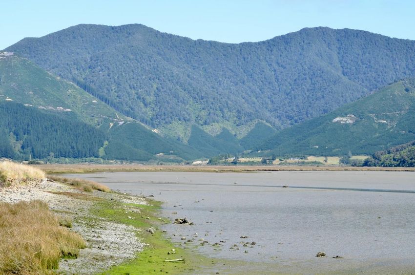
fundamental nature of the estuary has not obviously changed within their lifetimes:
The estuary “has always been muddy,” and that “it’s never smelt like a ‘clean’ estuary.” As
one participant mentioned: “I wouldn’t know that the estuary has gotten muddier and
muddier... I know some people talked about how the estuary used to be sandy, now it’s just
soft, fine sediment. It’s been pretty muddy for my lifetime.”
3 The participants’ ages ranged between 30-80 years of age – this range shows that there are most likely two
different generations (in terms of birth years), however they were selected by the Kotahitanga Alliance due to
their connection and knowledge of Pelorus/Te Hoiere. For this report, the term ‘generation’ refers to Karl
Mannheim’s definition, where he states there are three elements to forming a generation: “a shared temporal
location (i.e. generational site or birth cohort); shared historical location (i.e. ... exposure to a common period);
and finally a shared socio-cultural location” (Gilleard & Higgs, 2002). For this report in particular, this definition
relates to how the participants share a common physical connection to Pelorus/Te Hoiere.
16A local oral history of environmental change in Pelorus / Te Hoiere, Marlborough
Looking to the future
During the interviews, it became quickly evident that the area is important to all of the
interviewees, and the well-being of the environment was particularly emphasised. The
Pelorus/Te Hoiere catchment provides for social and economic stability, while also providing
in some places a scenic environmental backdrop for recreational activities.
Based on the responses to date, there is a support for planting throughout the catchment,
and for exotic species to be removed, especially from the banks of the rivers. There is also
major potential for lowland indigenous forest to be regenerated, which would allow for native
bird and bat species to flourish. This would also likely mean some form of ongoing predator
control. These desires reflect a concern for the preservation of native flora and fauna in the
catchment, but not on specific aspirations for the estuary.
Learning from the past could provide a platform for discussions about restoration and
adaption to climate change as well. In particular, the Rai River clean-up mentioned by one
of the interviewees was seen as a good example of collaboration between by Outward
Bound and local Rai Valley farmers. Despite this, it is apparent that from the interviews
conducted, there is a general feeling of uncertainty and confusion from the community –
particularly about what is being planned for the catchment by the Kotahitanga Alliance, how
it will happen, and what it means for the community.
This suggests the need for ongoing dialogue about what the future could look like for the
catchment, and perhaps going further than discussing pest control and riparian planting. As
discussed in Environment Aotearoa, there are knowledge gaps in how land is utilised. The
Kotahitanga Alliance is in the position of helping to reduce these gaps by the reciprocal and
respectful exchange of ideas and knowledge. The aim being to help improve ecological
resilience, which underpins the rural economy, by adapting land-use practices to reduce
runoff of sediments, bacteria, and nutrients. This should also help to improve biodiversity.
17A local oral history of environmental change in Pelorus / Te Hoiere, Marlborough
Acknowledgements
This research was undertaken under a Lincoln University summer scholarship, jointly funded
with the Department of Conservation.
I cannot express enough thanks to Lincoln University, Al Check and Matt Hippolite from the
Department of Conservation, Matt Oliver from the Marlborough District Council and Julia
Eason from Ngāti Kuia, for their guidance, advice and support for the duration of this
research.
This project would not have been completed without the support of my supervisor, Dr Steve
Urlich. Thank you, Steve, for all the encouragement and support over the summer, and for
your patience with helping me edit the final report. If I have not said it enough, thank you!
Finally, to the participants – thank you all so much. I am extremely grateful to everyone who
took time from their day to participate in the research – without you, this project would not
have been possible. Everyone was incredibly helpful, kind and accommodating. I sincerely
hope we have the opportunity to work together again in the future.
18A local oral history of environmental change in Pelorus / Te Hoiere, Marlborough
Appendix
Question sheet detailing the questions that participants were asked, including prompts and
the aim/s for each section.
19A local oral history of environmental change in Pelorus / Te Hoiere, Marlborough
References
Bowie, L.J.S. (1963). Land utilisation in the Marlborough Sounds. MA (Geography) thesis.
Canterbury, NZ: University of Canterbury.
Brayshaw, N.H. (1964). Canvas and Gold: A history of the Wakamarina goldfields and lower
Pelorus Valley. Blenheim: Brayshaw
Gilleard, C., & Higgs, P. (2002). The third age: Class, cohort or generation? Ageing and
Society, 22(3), 369-382. doi:10.1017/S0144686X0200870X
Department of Conservation. (n.d.) Pelorus Bridge Scenic Reserve. Retrieved from
https://www.doc.govt.nz/parks-and-recreation/places-to-
go/marlborough/places/pelorus-bridge-scenic-reserve/
Gray, C. (2012). Soil Properties in the Rai/Pelorus Catchment. Marlborough District Council
Technical Report 12-005. Blenheim.
Guerrero-Gatica, M., Aliste, E., & Simonetti, J.A. (2019). Shifting Gears for the Use of the
Shifting Baseline Syndrome in Ecological Restoration. Sustainability, 11(5), 1458, 1-
12. https://doi.org/10.3390/su11051458
Hale, A.M. (1960). Rai Valley: 1909-1959. Blenheim: The Rai Valley Co-Operative Dairy
Factory Company Limited
Kotahitanga mō te Taiao. (2019, June). Kotahitanga mō te Taiao Strategy. Retrieved from
https://www.doc.govt.nz/contentassets/cf2bf2f877544dc29594442365ca797c/kotahit
anga-mo-te-taiao-strategy.pdf
Lane, R. (1997). Oral histories and scientific knowledge in understanding environmental
change: a case study in the Tumut Region, NSW. Australian Geographic Studies
35:195–205.
Lauder, G.A. (1987). Coastal landforms and sediments of the Marlborough Sounds. PhD
Thesis. Christchurch, NZ: University of Canterbury.
Marlborough District Council. (2015). State of the Environment Report: Our land, our water,
our place. Retrieved from https://www.marlborough.govt.nz/environment/state-of-the-
environment-reporting/state-of-the-environment-report-2015
Marlborough Express. (1904). Floods in the Pelorus: The valley completely submerged. May
19, 1904. p. 3. Retrieved from
https://paperspast.natlib.govt.nz/newspapers/MEX19040319.2.30.4
Marlborough Express. (1913). The Dairying Industry: Progress in Marlborough. April 9, 1913.
p. 2. Retrieved from https://paperspast.natlib.govt.nz/newspapers/MEX19130409.2.8
Marlborough Express. (1920a) Page 4 Advertisements: Column 6. July 28, 1920. p. 4.
Retrieved from https://paperspast.natlib.govt.nz/newspapers/MEX19200728.2.22.6
Marlborough Express. (1920b). Scarcity of timber. July 14, 1920. p. 2. Retrieved from
https://paperspast.natlib.govt.nz/newspapers/MEX19200714.2.4
20A local oral history of environmental change in Pelorus / Te Hoiere, Marlborough
Maxwell, K., & MacDiarmid, A.B. (2016) Taking Stock: Oral histories about changes in
marine fauna observed locally in the Hauraki Gulf and along the Otago-Catlins coast,
New Zealand, 1926–2008. Wellington: Ministry for Primary Industries; 2016.
Retrieved from https://www.mpi.govt.nz/dmsdocument/13125-aebr-173
Ministry for the Environment. (2018, December). Essential Freshwater: Healthy water, fairly
allocated. Retrieved from https://www.mfe.govt.nz/publications/fresh-water/essential-
freshwater-healthy-water-fairly-allocated
Ministry for the Environment & Stats NZ (2019). New Zealand’s Environmental Reporting
Series: Environment Aotearoa 2019. Available from www.mfe.govt.nz and
www.stats.govt.nz
Ministry for the Environment. (2019, September). Draft National Policy Statement for
Freshwater Management. Retrieved from https://www.mfe.govt.nz/publications/fresh-
water/draft-national-policy-statement-freshwater-management
Ministry for the Environment. (2020). Action for healthy waterways. Retrieved from
https://www.mfe.govt.nz/action-for-healthy-waterways
Mitchell, H., & Mitchell, J. (2007). Te Tau Ihu O Te Waka: A History of Maori of Nelson and
Marlborough – Vol ll: Te Ara Hou – The new society. Wellington: Huia Publishing
New Zealand Soil Bureau. (1968). General Survey of the soils of the South Island, New
Zealand. New Zealand Soil Bureau Bulletin 27. Includes maps at 1:250 000.
Ngāti Kuia. (2015). About us: History. Retrieved from http://www.ngatikuia.iwi.nz/
Paton, B.R. (1982). Sawmill pioneers in the Pelorus. Diploma in Parks and Recreation
dissertation. Canterbury, NZ: Lincoln College.
Pauly, D. (1995). Anecdotes and the shifting baseline syndrome of fisheries. Trends in
Ecology Evolution. 10(10):430.
Robertson, M., Nichols, P., Horwitz, P., Bradby, K., & MacKintosh, D. (2000). Environmental
narratives and the need for multiple perspectives to restore degraded landscapes in
Australia. Ecosystem Health. 6(2):119–133. doi:10.1046/j.1526-0992.2000.00013.x.
Radio New Zealand (RNZ). (2019, December). Marlborough's at-risk catchment secures
restoration funds. Retrieved from
https://www.rnz.co.nz/news/national/404979/marlborough-s-at-risk-catchment-
secures-restoration-funds
Soga, M., & Gaston, K.J. (2018). Shifting baseline syndrome: causes, consequences, and
implications. Frontiers in Ecology and the Environment. 16(4) 222-230.
Stephens, J. (2008). Timber Pioneers – Brownlee and Baigent. Retrieved from
http://www.theprow.org.nz/people/marlborough-nelson-timber-
pioneers/#.XkOHrhMzY6g
Stephens, J. (2009). Wakamarina Gold. Retrieved from
http://www.theprow.org.nz/enterprise/wakamarina-gold/#.XkN2LxMzY6g
Stephens, J. (2013). Rai Valley. Retrieved from http://www.theprow.org.nz/places/rai-
valley/#.XkODhRMzY6g
21A local oral history of environmental change in Pelorus / Te Hoiere, Marlborough
Stuff. (2019, December). Pelorus catchment to receive funding to improve its water quality.
Retrieved from https://www.stuff.co.nz/environment/117990305/pelorus-catchment-
to-receive-funding-to-improve-its-water-quality#comments
Tait, A. (2017). Interpolation of mean annual rainfall for Marlborough District. NIWA Report
2017004WN. Prepared for Marlborough District Council. Wellington, NZ: National
Institute of Water & Atmospheric Research
Urlich, S.C., & Handley, S.J. (2020). History of pine forestry in the Pelorus/Te Hoiere
catchment and the Marlborough Sounds. NZ Journal of Forestry 65(2) 19-24.
Waitangi Tribunal. (2008). Te Tau Ihu o Te Waka a Maui: Report on northern South Island
claims Volume III. Wellington: Waitangi Tribunal; 2008
Walls, G.Y., & Laffan, M.D. (1986). Native vegetation and soil patterns in the Marlborough
Sounds, South Island, New Zealand. New Zealand Journal of Botany, 24: 293-313.
Ward, F.L. (1987). A History of the Pelorus Bridge Scenic Reserves: 1865-1987. Blenheim:
F.L Ward
Williams, B., & Riley, M. (2018). The Challenge of Oral History to Environmental History.
Environment and History. https://
22You can also read