Active Uplift of Southern Tibet Revealed - 10-13 Oct. GSA Connects 2021 VOL. 31, NO. 8 | AUGUST 2021 - Geological Society ...
←
→
Page content transcription
If your browser does not render page correctly, please read the page content below
10–13 Oct. GSA Connects 2021

                          VOL. 31, NO. 8 | AUGUST 2021

Active Uplift of Southern
     Tibet Revealed
Special Paper 550

                                                                                          Large Meteorite Impacts and Planetary
                                  Large Meteorite Impacts and
                                     Planetary Evolution VI

                                                                                          Evolution VI
Large Meteorite Impacts and
   Planetary Evolution VI

                                                                                          Edited by Wolf Uwe Reimold and Christian Koeberl
                                                                                           This volume represents the proceedings of the homonymous international conference
                                                                                             on all aspects of impact cratering and planetary science, which was held in October
                                                                                               2019 in Brasília, Brazil. The volume contains a sizable suite of contributions dealing
                                                                                                with regional impact records (Australia, Sweden), impact craters and impactites,
                                                                                   IN           early Archean impacts and geophysical characteristics of impact structures, shock
                                                                                  PRESS         metamorphic investigations, post‑impact hydrothermalism, and structural geology and
                                                                                               morphometry of impact structures—on Earth and Mars. Many contributions report
                                    Edited by Wolf Uwe Reimold and Christian Koeberl          results from state‑of‑the‑art investigations, for example, several that are based on
                                             Special Paper 550
                                                                                            electron backscatter diffraction studies, and deal with new potential chronometers and
                                                                                          shock barometers (e.g., apatite). Established impact cratering workers and newcomers
                                                                                          to this field will both appreciate this multifaceted, multidisciplinary collection of impact
                                           SPE550, 642 p.,                                cratering studies.
                                        ISBN 9780813725505
                                             IN PRESS

                                                                                                                                                                         Memoir 219
                              PROVIDENCIA ISLAND: A Miocene                                                                                                          Memoir 219

                              Stratovolcano on the Lower Nicaraguan Rise,                                                                    PROVIDENCIA ISLAND

                              Western Caribbean—A Geological Enigma
                                                                                                                                              A Miocene Stratovolcano on the Lower Nicaraguan Rise,
                                                                                                                                                Western Caribbean—A Geological Enigma Resolved

                              Resolved
                              By Alan L. Smith, M. John Roobol, Glen S. Mattioli, George E. Daly,
                              and Joan E. Fryxell
                                                                                                                                         IN
                                                                                                                                        PRESS
                              Providencia is the only example of subaerial volcanism on the Lower Nicaraguan
                              Rise. In this volume, the authors examine this volcanism and the geological history
                              of the western Caribbean and the Lower Nicaraguan Rise, whose origin and role in
                              the development of the Caribbean plate has been described as enigmatic and poorly                               By Alan L. Smith, M. John Roobol, Glen S. Mattioli, George E. Daly, and Joan E. Fryxell

                              understood. While the Providencia alkaline suite is similar to others within the Western
                              Caribbean Alkaline Province, its subalkaline suite is unique, having no equivalent within
                              the province. In order to unravel its complex history and evolution, this volume presents                                       MWR219, 101 p.,
                              new and previously published results for the geology, geochemistry, petrology, and isotopic
                              ages from the Providencia island group.
                                                                                                                                                            ISBN 9780813712192
                                                                                                                                                                IN PRESS

                        GSA BOOKS } https://rock.geosociety.org/store/
                         toll‑free +1.800.472.1988 | +1.303.357.1000, option 3 | gsaservice@geosociety.org
AUGUST 2021 | VOLUME 31, NUMBER 8
SCIENCE
4 Active Uplift of Southern Tibet Revealed
Michael Taylor et al.
GSA TODAY (ISSN 1052-5173 USPS 0456-530) prints news
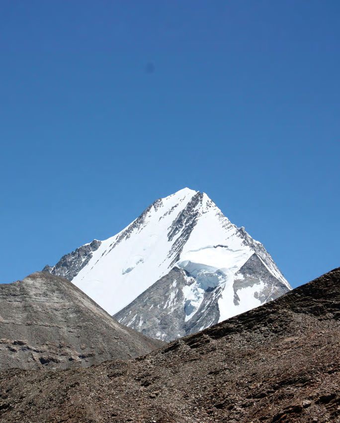
and information for more than 22,000 GSA member readers Cover: View to the Northeast of the Lopu Kangri massif of the
and subscribing libraries, with 11 monthly issues (March- Gangdese Range with Kailas Formation rocks folded and faulted by
April is a combined issue). GSA TODAY is published by The the Great Counter Thrust system in the foreground. Photo by Andrew
Geological Society of America® Inc. (GSA) with offices at
3300 Penrose Place, Boulder, Colorado, USA, and a mail- Laskowski. For the related article, see pages 4–10.
ing address of P.O. Box 9140, Boulder, CO 80301-9140, USA.
GSA provides this and other forums for the presentation
of diverse opinions and positions by scientists worldwide,
regardless of race, citizenship, gender, sexual orientation,
religion, or political viewpoint. Opinions presented in this
GSA CONNECTS 2021
publication do not reflect official positions of the Society.
© 2021 The Geological Society of America Inc. All rights 12 Registration and Information 16 Geoheritage: Geology of the
reserved. Copyright not claimed on content prepared Community, for the Community,
wholly by U.S. government employees within the scope of
their employment. Individual scientists are hereby granted 13 Noontime Lectures by the Community
permission, without fees or request to GSA, to use a single
figure, table, and/or brief paragraph of text in subsequent
work and to make/print unlimited copies of items in GSA
14 Commitment to Care 18 GeoCareers
TODAY for noncommercial use in classrooms to further
education and science. In addition, an author has the right 15 Scientific Field Trips 18 Be a Mentor and Make a
to use his or her article or a portion of the article in a thesis
or dissertation without requesting permission from GSA, Difference
provided the bibliographic citation and the GSA copyright 15 Short Courses
credit line are given on the appropriate pages. For any
other use, contact editing@geosociety.org.
Subscriptions: GSA members: Contact GSA Sales & Service,
+1-800-472-1988; +1-303-357-1000 option 3; gsaservice@
geosociety.org for information and/or to place a claim for
non-receipt or damaged copies. Nonmembers and institutions:
GSA NEWS
GSA TODAY is US$108/yr; to subscribe, or for claims for
non-receipt and damaged copies, contact gsaservice@ 19
Mentoring Tomorrow’s 24
Student and Early Career
geosociety.org. Claims are honored for one year; please
allow sufficient delivery time for overseas copies. Peri- Geoscience Leaders at the Professional Update: Unlocking
odicals postage paid at Boulder, Colorado, USA, and at 2021 Section Meetings the Mysteries of Museum Careers
additional mailing offices. Postmaster: Send address
changes to GSA Sales & Service, P.O. Box 9140, Boulder, CO
80301-9140. 20
Rock Stars: David Dale Owen 26
Connecting the Geological and
GSA TODAY STAFF (1807–1860): Frontier Geologist Biomedical Sciences: GSA’s
Executive Director and Publisher: Vicki S. McConnell Geology and Health Scientific
Science Editors: Mihai N. Ducea, University of Arizona, 22
2020–2021 GSA Science Division
Dept. of Geosciences, Gould-Simpson Building, 1040 E 4th Communication Fellowship
Street, Tucson, Arizona 85721, USA, ducea@email.arizona
.edu; Peter Copeland, University of Houston, Department
Wrap-Up: Communicating 28 Geoscience Jobs & Opportunities
of Earth and Atmospheric Sciences, Science & Research about the Geosciences during
Building 1, 3507 Cullen Blvd., Room 314, Houston, Texas a Pandemic 29 GSA Foundation Update
77204-5008, USA, copeland@uh.edu.
Managing Editor: Kristen “Kea” Giles, kgiles@geosociety.org,
gsatoday@geosociety.org 23
Earth to Economy: Accelerating 30 Success in Publishing: Navigating
Graphics Production: Emily Levine, elevine@geosociety.org Innovation for Climate-Change the Process
Advertising Manager: Ann Crawford,
Solutions
+1-800-472-1988 ext. 1053; +1-303-357-1053; 31 2022 GSA Section Meetings
Fax: +1-303-357-1070; advertising@geosociety.org
GSA Online: www.geosociety.org
GSA TODAY: www.geosociety.org/gsatoday
Printed in the USA using pure soy inks.
Active Uplift of Southern Tibet Revealed

Michael Taylor*, Dept. of Geology, University of Kansas, Lawrence, Kansas 66045, USA; Adam Forte, Dept. of Geology and Geophysics,
Louisiana State University, Baton Rouge, Louisiana 70803, USA; Andrew Laskowski, Dept. of Earth Sciences, Montana State University,
Bozeman, Montana 59717, USA; Lin Ding, Institute of Tibetan Plateau Research, Chinese Academy of Sciences, Beijing, China

ABSTRACT                                             of the Yarlung River are superimposed upon        at depth at geodetic and millennial time
   North of the Himalayas is the Tibetan             the internally drained portion of the Tibetan     scales (18–22 cm/yr) (Ader et al., 2012; Lavé
plateau—the largest physiographic feature            plateau, which by area is the plateau’s larg-     and Avouac, 2000). However, disagreement
on Earth related to intercontinental colli-          est surficial feature, forming a long wave-       exists on whether the downdip geometry of
sion. Here, we study the rugged Gangdese             length depression encompassing ~600,000           the MHT is planar, involves crustal ramps
Range along the southern drainage divide             km2 (Fielding et al., 1994) (Fig. 4). Given       beneath the high-relief topographic steps
of the Tibetan plateau using a synthesis of          such vastness, the question of how the            (e.g., Whipple et al., 2016; Ghoshal et al.,
geologic, thermochronologic, and interseis-          internally drained Tibetan plateau formed is      2020), or if surface breaking splay faults
mic geodetic observations that reveal that           a matter of pressing interest, although           accommodate a significant portion of India-
southern Tibet’s Gangdese Range is under-            research to-date has been unable to deter-        Asia convergence (e.g., Murphy et al., 2013).
going active surface uplift at present-day           mine a conclusive cause (Sobel et al., 2003;      Seismic imaging is consistent with a low-
rates rivaling the Himalaya. Uplift has              Horton et al., 2002; Kapp and DeCelles,           angle (10–20°) north-dipping décollement
likely been sustained since the early                2019). In the following, we present prelimi-      for the MHT, with its northward extent
Miocene, and we hypothesize that surface             nary results of ongoing work along the            occurring below the main Himalayan peaks
uplift of the Gangdese Mountains led to the          southern drainage divide of the Tibetan pla-      at ~50 km depth (Makovsky and Klemperer,
development of Tibet’s internally drained            teau, which coincides with the Gangdese           1999). North of the main Himalayan peaks
plateau, as well as potentially reversed the         Range. Compilations of low-temperature            are the northern Himalayan gneiss domes,
course of the paleo Yarlung River, in tan-           thermochronology, global positioning sys-         which are exposed between the South
dem with exhumation of the Himalayan                 tem (GPS), and terrain analysis reveal that       Tibetan fault system in the south and the
gneiss domes. We suggest the data are con-           the Gangdese Range has experienced recent         Indus-Yarlung suture (IYS) zone to the
sistent with active thrust duplexing, bal-           surface uplift and is likely active today. This   north (Figs. 2 and 3). The gneiss domes are
anced by upper crustal extension, effec-             critical new observation sheds light on the       cored by variably deformed orthogneiss and
tively extending the active décollement              style of active shortening across the India-      locally are intruded by leucogranites,
between the underthrusting Indian plate              Asia collision zone, with implications for        emplaced between 37 and 34 Ma (e.g., Lee
and the Eurasian upper plate more than 200           large-scale drainage reorganizations for          et al., 2000; Larson et al., 2010). The gneiss
km north of the High Himalayas.                      the Himalayas and Tibetan plateau. We             domes are juxtaposed against Tethyan sedi-
                                                     begin with the neotectonic setting for the        mentary rocks in the hanging wall, with
INTRODUCTION                                         Himalayan-Tibetan orogen, followed by a           rapid cooling regionally initiating by 12 ± 4
   The Himalayan-Tibetan orogen hosts the            discussion of potentially active structures,      Ma (Lee et al., 2004) (Figs. 2 and 3).
tallest and largest area of high topography,         which suggest the Gangdese as a potential            The remainder of active convergence is
and thickest crust, on Earth, representing a         candidate to explain recent fluvial reorgani-     accommodated throughout the Tibetan pla-
dramatic expression of crustal shortening            zations across southern Tibet.                    teau by north-striking normal faults and
(Fielding et al., 1994) (Figs. 1–4). A topo-                                                           generally northeast- and northwest-striking
graphic swath profile between longitudes             THE INDIA-ASIA COLLISION ZONE                     strike-slip structures (e.g., Taylor and Yin,
85–90°E (Figs. 1–4) illustrates from south           AND THE GANGDESE RANGE                            2009). The geometry and kinematics of
to north the flat Indo-Gangetic plain, the              The India-Asia collision zone presently        active structures accommodating east-west
foothills of the sub-Himalaya, the extreme           absorbs ~4 cm/yr of geodetic convergence          extension across southern Tibet and fault
relief of the High Himalayas, the broad east-        as India moves in the N20E direction rela-        scarps are consistent with recent seismo-
west topographic trough of the Yarlung               tive to stable Eurasia (Zhang et al., 2004).      genic activity (Taylor and Yin, 2009). Since
River valley, and the high crest of the              Most agree that the Main Himalayan Thrust         the onset of extension may date when the
Gangdese Range with its gentle north-facing          (MHT) and its updip imbricate fault splays        Tibetan plateau attained its maximum ele-
slope. Regionally, geomorphic features north         accommodate the majority of convergence           vation, this timing has been determined

GSA Today, v. 31, https://doi.org/10.1130/GSATG487A.1.

*Corresponding author: mht@ku.edu

4 GSA Today | August 2021
82°E                  84°E             86°E              88°E              90°E              92°E            94°E            96°E            98°E


                                                                               Internal Drainage

                                                                                                                                        Three Rivers
 32°N

        Indus

        Sutlej


                                             S1                                                                                 Yarlung
 30°N


 28°N


         T.chron System
         Apatite (U-Th)/He
         Apatite FT            Elevation (km)
         Zircon (U-Th)/He
         Zircon FT              1 2 3 4 5 6      GPS Station
                                                                                                                                                                100 km
                                                                  West                                    East
                                                                         400 200      0    200 400
                                                                 Distance from Center Along Small Circles (km)

Figure 1. Shuttle Radar Topography Mission 90-m color shaded elevation map. Thermochronology data (Laskowski et al., 2018; Thiede and Ehlers, 2013) in
Figure 4 are shown with thermochronometer type. Color scale bar indicates east-west position from swath profile in Figure 4. Open symbols—location in
the hanging wall of a normal fault; white circles—GPS stations from Liang et al. (2013); dashed outlines—areas sampled for Figure 4; solid lines mark topog-
raphy and precipitation in Figure 4A. Thick dotted lines mark centerline for distance measured along small circles in Figure 4A. Individual colored swaths
sample dominant rivers in Figure 4B. Thick black lines are rivers and catchment areas for Sutlej, Indus, Yarlung, and Three Rivers, and zone of Internal
Drainage. Red box shows location of Figure 2. Red symbol shows location of Figure S1 [see text footnote 1].

primarily by understanding the exhumation                        –directed extension are discussed by                       the initiation age for one Gangdese Rift is ca.
history of the footwalls of north-striking                       Blisniuk et al. (2001), Kali et al. (2010),                16 Ma using zircon U-Th/He data (Burke et
normal faults. One example is the northern                       Langille et al. (2010), Yin and Taylor (2011),             al., 2021). The Gangdese Rifts become more
Lunggar Rift that locally has up to 25 km of                     Sundell et al. (2013), and Styron et al. (2015).           northwest striking in the western Lhasa ter-
top-to-the-east displacement and initiated                         Here we focus on the Gangdese Range of                   rane, and rift-bounding faults are more linear
in the middle Miocene with uniformly low                         southern Tibet that locally has nine active                in map pattern with the westernmost rifts,
slip rates (
87ºE 88ºE antiform (Figs. 2 and 3), with a steeply south-
30ºN dipping forelimb of Kailas Formation in the
JPg
KPlv
A’ KPlv
south, and a gently north-dipping backlimb of
Linzizong volcanic rocks to the north (Figs. 2
and 3). The crest of the antiform is located
at the southern Tibet drainage divide and
JPg locally is cut by the north-striking Gangdese
Kl
GANGDE Rifts (Figs. 1 and 5).
SE MTNS
. To better understand the structural and
JPg geomorphological complexities associated
Kl with the Gangdese Range, we compiled
OMk
topographic (Lehner et al., 2008), low-tem-
JPg OM perature thermochronometer (Thiede and
k
Ngamring GCT L Ehlers, 2013; Laskowski et al., 2018), geo-
oph Kx
Kx detic (Liang et al., 2013), and rainfall
GCT IYSZ
mlg Yarlu oph (Bookhagen and Burbank, 2006) data for
ng River
the Himalaya and Tibet onto a single, com-
GCT mlg
Ml
29ºN
Lazi posite north-south swath profile (Fig. 4). A
full description of the data projections for
THS assembling Figure 4 is provided in the sup-
plemental material (see footnote 1).
rm
orm
rm
im yan Antifo
aly IS GANGDESE DUPLEXING ACTIVE?
rth Him
Nort
GHS L A recent structural model links the GCT
GHS with the Gangdese Thrust, interpreted as
the largely buried roof thrust of a north-dip-
THS ping duplex (Laskowski et al., 2018). The
Gangdese duplex model is consistent with
THS
seismic reflection data gathered during the
INDEPTH active-source and Hi-CLIMB
F experiments, with seismic imaging show-
ST
THS
ing imbricated, north-dipping reflectors
A L
becoming shallower at upper structural
GHS
levels (Makovsky and Klemperer, 1999;
28ºN
Qomolangma Nábělek et al., 2009). In the following, we
(Everest) STF
L 50 km suggest that the Gangdese duplex may be an
active structure.
Elevations in Figure 4 illustrate the well-
Paleogene-Neogene Oligocene-Miocene Cretaceous
L OMk oph known high relief of the Himalaya rising from
leucogranite Kailas Formation Xigaze Ophiolite
Jurassic-Paleogene Cretaceous Cambrian-Paleocene
the Indian subcontinent. As noted previously
JPg Kl THS
Gangdese batholith Lhasa terrane Tethyan strata (undiv.) (e.g., Bookhagen and Burbank, 2006), mean
Cretac.-Paleogene Cretaceous Neoproterozoic Greater annual precipitation values are inversely cor-
KPlv Kx GHS
Linzizong Volcanics Xigaze Forearc Himalaya Sequence related with elevation—this is clear in the
Miocene Sedimentary-matrix low-elevation regions located south of the
Ml mlg
Liuqu Fm. mélange (undiv.)
Himalaya receiving large amounts of precipi-
Figure 2. Geologic map with rock units (see Fig. 1). GCT—Great Counter Thrust sys- tation (up to 4 m/year), compared to the arid
tem; IYSZ—Indus-Yarlung suture zone; STF—South Tibetan Fault. Bold dashed lines interior of Tibet to the north.
with arrows are antiforms—fold axis for the Gangdese Range with the long axis of
asymmetric diamond indicates steeply south-dipping Kailas Formation. Red lines— Low-temperature thermochronologic data
active normal faults. Elevation contours are 200 m and 500 m (bold). Modified from (Laskowski et al., 2018) show dominantly
Laskowski et al. (2018).
Miocene cooling ages over most of southern
Tibet, with 23–15 Ma cooling, overlapping in
nology data near Lhasa suggest the GT was field because it is either largely buried under time with development of the GCT (Fig. 4).
active between 27 and 23 Ma (Harrison et al., the Kailas Formation, the GT occurs in the North of the Gangdese Range and south of the
1992). However, other studies argue that the footwall of the GCT, or the GCT forms a Bangong-Nujiang suture zone, thermochro-
GT is not exposed along the IYS zone, and branch line with the GT, forming a roof and nologic data show dominantly late Cretaceous
therefore is not a mechanism for accommo- floor thrust respectively, to a north-dipping cooling ages for central Tibet, consistent with
dating large-magnitude crustal thickening duplex beneath the Gangdese Range. The little to no late Cenozoic exhumation. The
(Aitchison et al., 2003). Alternatively, the GT map pattern is consistent with the Gangdese thermochronometric data are also consistent
may be a shear zone difficult to identify in the duplex forming an asymmetric south-verging with more recent exhumation across the ~150
6 GSA Today | August 2021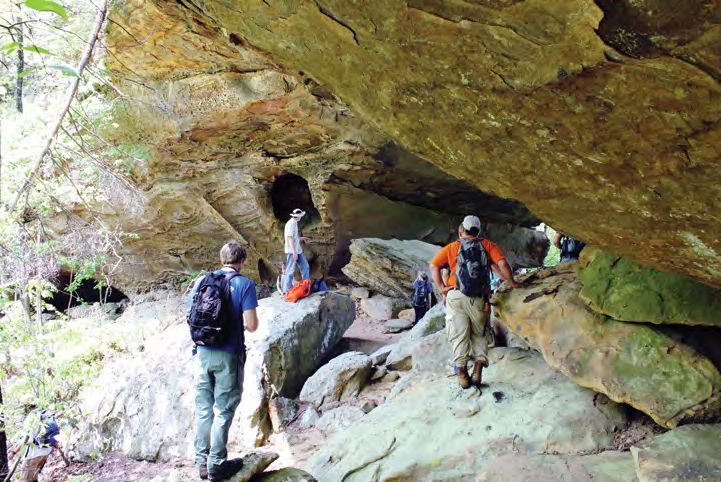
km width of the Gangdese Range. Areas of
focused exhumation across the Gangdese are
co-located with GPS data showing significant
positive vertical velocities, consistent with
N GCT active exhumation.
GT
??
A comprehensive data set of GPS veloci-
ties is presented in Liang et al. (2013),
including sparse information about the ver-
tical component of the velocity field (Fig.
4). The horizontal north-south component
Lhasa Terrane of the velocity field indicates north-south
India-Asia Suture Zone rocks convergence ~40 mm/yr relative to stable
Tethyan Himalaya Sequence Eurasia, with a velocity gradient of ~20
Greater Himalaya Sequence mm/yr across the Himalaya and the IYS
Lesser Himalaya Sequence zone, consistent with previous results (e.g.,
Siwaliks (foreland basin) Bilham et al., 1997; Zhang et al., 2004). The
vertical component of the interseismic veloc-
ity field also shows that the Himalayas are
Figure 3. Model of the Indo-Asian collision illustrating rock uplift above thrust ramps (Main Himalayan
Thrust) or duplexes forming topographic relief for the Gangdese Range, and a topographic divide rising at 2.56 ± 1.23 mm/yr, consistent with
between internal and external drainage (dashed black line) controlling flow direction of the Yarlung both previous geodetic studies (e.g., Bilham
River (solid blue line). Himalayan gneiss domes (1) and the Gangdese Duplex (2). Structures adapted
from Laskowski et al. (2018), Long et al. (2011), and Nábělek et al. (2009). (VE = 5.) GCT—Great Counter et al., 1997; Liang et al., 2013) and surface
Thrust system; GT—Gangdese Thrust. uplift rates determined from geomorphology
PT
Precipitation (m/yr)
10 1
8
Elevation (km)
A
Mean Annual
PT2
6
Mean of Means Swaths 40-56
5 Min and Max of Means 4
Extremes 2
0 0
10
ID
Elevation (km)
B TR
Drainage
56 48 40 32 25 17 9 1
5
YA
0 FR
Cooling Age (Ma) Cooling Age (Ma)
10
Elevation (km)
C 1 Ma
Ap FT Ap He
1
5
10 Ma 10
0 100 Ma 100
West East
10 400 200 0 200 400
Elevation (km)
D Distance from Center Along Small Circles (km) Zi He Zi FT
1 Ma 1
5
10 Ma 10
0 100 Ma 100
Velocity (cm/yr)
4 Horizontal GPS Velocity in Plane of Swaths East Component
E North Component
2
0
Vertical GPS Velocity
Indus-Yarlung Suture Zone Mean Vertical in Zone Bangong-Nujiang Suture Zone
F
Velocity (mm/yr)
4 1-σ of Mean
0
E W W E
-4
0 50 100 150 200 250 300 350 400 450 500 550 600 650
Distance Along Swath (km)
Figure 4. Swath profile of areas in Figure 1. (A) Averages of sixteen 20-km-wide swaths through Shuttle Radar Topography Mission 90 m elevation and
Tropical Rainfall Measurement Mission 2B31 (Bookhagen and Burbank, 2006) mean annual precipitation. Topographic swath is the same for panels B, C,
and D. PT—physiographic transition. (B) 20-km-wide swaths showing the location of major divides between the internally drained Tibet (ID), three rivers
(TR), Yarlung (YA), and frontal Himalaya rivers (FR). Swath locations are shown in Figure 1 and colored by distance from swath center. (C) Apatite and (D)
zircon thermochronology data from Thiede and Ehlers (2013) and Laskowski et al. (2018), colored by distance from the centerline, with y-axis position for
cooling age. (E) Projected horizontal global positioning system (GPS) velocities in the plane of individual swaths (solid symbols) and the corresponding N
and E components (Liang et al., 2013). (F) All available data for the vertical component of GPS velocities (Liang et al., 2013). Solid black lines—average of
defined zones; dotted lines—one standard deviation of the mean.
www.geosociety.org/gsatoday 7
Former Drainage Divide?
                                                                                               ‘West’ Directed Network          ‘East’ Directed Network
          A
                                 Southern Tibet Drainage Divide

                                                                                                    ‘West’ Directed Networks
                                                                                                                                                            6

                                                                                                                                                                Elevation (km)
   B                                                                                                                                                        4
         Main Channel Crosses      Main Channel & Minor Tributaries
         Normal Fault              Major Northern Tributaries                                                                                               2
                                   Major Southern Tributaries
                                                                                                                                                            0
2500                            2000                              1500                            1000                          500                        0
                                                                         River Distance (km)

   C                                                                                                                                                        6

                                                                                                                                                                Elevation (km)
                                                                                                                                                            4

                                                                                                                                                            2

 40                 35                  30                   25                 20                       15              10                  5            00

Figure 5. (A) Yarlung catchment with stream network. See Figure 1 for location. White dots indicate large junction angles consistent with west-directed
paleoflow of the Yarlung River. Yellow stars mark reference locations on panels B and C. (B) Long profile with tributaries north (blue) and south (red) of the
main river. (C) χ-elevation profile of B. Thick yellow lines—active normal faults.

and leveling data (i.e., Lavé and Avouac,                from a southward flow to northward into                    Tibet. Our findings effectively extend the
2000). Surprisingly, the mean of the vertical            Tibet’s interior, by the creation of high                  orogenic thrust wedge well into Tibet, where
component of the velocity field across an                topography across the Gangdese Range. The                  the MHT soles into a north-dipping thrust
~170-km-wide zone spanning the IYS zone                  resulting high topography across the                       ramp below the Gangdese Range (Fig. 2).
and the Gangdese Range (Fig. 4) is 3.17 ±                Gangdese Range led to development of the                   Our model, combined with the geometry of
0.46 mm/yr, which is similar within error to             internally drained Tibetan plateau and drain-              the Gangdese Rift and Great Counter Thrust
the vertical velocity measured for the                   age integration along the Indus-Yarlung                    systems, explains the GPS, topographic, and
Himalayas. The mean of the vertical veloc-               suture zone, creating the modern headwaters                exhumation patterns of the Tibetan plateau
ity north of the Gangdese Range and south                for the Yarlung River. The GPS vertical                    (Figs. 2 and 4).
of the Bangong-Nuijiang suture zone grad-                velocity field is consistent with surface uplift              In addition to causing a flow reversal of
ually decreases from ~3 mm/year in the                   of the Gangdese Range ongoing today, and                   previously trans-Himalayan rivers, we sug-
south, to 0.09 ± 1.57 mm/yr to the north.                that deep-seated crustal shortening (e.g.,                 gest the same process likely elevated sur-
Locally, vertical velocities related to freeze-          DeCelles et al., 2002; Styron et al., 2015) is             face topography to a critical threshold in the
thaw cycles and other surface processes                  balanced by upper crustal extension, rather                western region of the southern Gangdese
may occur in the proximity of the large                  than surface lowering due to pure shear                    Range and IYS zone (Fig. 1), also resulting
saline lakes north of the Gangdese Range.                deformation that occurs to the north in cen-               in the reversal of the paleo west-flowing
However, because all of the available values             tral Tibet (Taylor and Yin, 2009). Pure shear              Yarlung River to its modern eastward
of the vertical velocity field in the Liang et           dilation, crustal thinning, and surface lower-             course. Locally, the geomorphology of the
al. (2013) data set are positive across the              ing is a key prediction arising from models of             east-flowing Yarlung River and its tributar-
Gangdese Range and show a significant                    extensional collapse for the entire Tibetan                ies is paradoxical, with much of its drainage
velocity gradient, we view the data as con-              plateau (e.g., Ge et al., 2015), but is inconsis-          network topology consistent with paleo-
sistent with active surface uplift across the            tent with results of active surface uplift                 westward flow. One example is a large
entirety of the Gangdese (Fig. 4).                       across the Gangdese Range.                                 (~180°) junction angle between the Yarlung
                                                            The vertical component of the GPS veloc-                and Lhasa rivers (Burrard and Hayden,
HYPOTHESIZED MECHANISM                                   ity field and geologic observations described              1907) with at least three additional and
FOR INTERNAL DRAINAGE                                    in the previous sections suggests that active              exceptionally large junction angles farther
DEVELOPMENT                                              crustal thickening is occurring ~150 km                    west, up to river distance of ~1300 km
  If surface uplift across the Gangdese                  north of the High Himalayan physiographic                  (Fig. 5). A recent alternative hypothesis for
Range is active, we posit the following                  transition (e.g., PT2, Fig. 4A; Hodges et al.,             this junction angle involves antecedence
hypothesis: fluvial reorganization of pre-               2004). This is incompatible with all current               (Laskowski et al., 2019), but this interpreta-
viously trans-Himalayan rivers with head-                models of Himalayan shortening, where the                  tion is not mutually exclusive. Additionally,
waters located in central Tibet, rerouted                active thrust wedge does not extend into                   former significant (now breached) drainage

8 GSA Today | August 2021
divides preserved in the eastern half of the ACKNOWLEDGMENTS Ge, W.P., Molnar, P., Shen, Z.K., and Li, Q., 2015,
Yarlung network divide nominally east- We thank Delores Robinson for insightful reviews Present-day crustal thinning in the southern and
that improved the clarity of the manuscript. We also northern Tibetan plateau revealed by GPS mea-
directed tributaries from west-directed trib- surements: Geophysical Research Letters, v. 42,
acknowledge helpful discussions with Andrew
utaries (Fig. 5A). The timing of an inferred Hoxey, Paul Kapp, John Gosse, Michael Murphy, no. 13, p. 5227–5235, https://doi.org/10.1002/
westward flow for the Yarlung River is Clay Campbell, Kelin Whipple. and Peter Clift. This 2015GL064347.
unknown. However, a recent study using project is funded by the National Science Foundation Ghoshal, S., McQuarrie, N., Robinson, D.M.,
to Forte (EAR-1917695), Laskowski (EAR-1917685), Adhikari, D.P., Morgan, L.E., and Ehlers, T.A.,
detrital zircons suggests a connection 2020, Constraining central Himalayan (Nepal)
and Taylor (EAR-1917706).
between the Indus River and the Gangdese fault geometry through integrated thermochronol-
Range (Bhattacharya et al., 2021)—if cor- ogy and thermokinematic modeling: Tectonics,
rect, this is consistent with a west-flowing REFERENCES CITED v. 39, no. 9, https://doi.org/10.1029/2020TC006399.
Ader, T., Avouac, J., Zeng-Liu, J., Lyon-Caen, H., Harrison, T.M., Copeland, P., Kidd, W.S.F., and
Yarlung River by ca. 27 Ma. Finer-scale evi-
Bollinger, L., Galetzka, J., Genrich, J., Thomas, Yin, A., 1992, Raising Tibet: Science, v. 255,
dence for past drainage network instability M., Chanard, K., Sapkota, S., Rajaure, S., Shres- p. 1663–1670, https://doi.org/10.1126/science
is observed for the Yarlung River and its tha, P., Ding, L., and Fluozat, M., 2012, Conver- .255.5052.1663.
tributaries, with several prominent knick- gence rate across the Nepal Himalaya and inter- Hodges, K.V., Wobus, C., Ruhl, K., Schildgen, T., and
points located downstream where the seismic coupling on the Main Himalayan Thrust: Whipple, K., 2004, Quaternary deformation, river
Implications for seismic hazard: Journal of Geo- steepening, and heavy precipitation at the front of
Yarlung River flows across the footwalls of physical Research, v. 117, B04403, https://doi.org/ the Higher Himalayan ranges: Earth and Planetary
several active north-striking normal faults 10.1029/2011JB009071. Science Letters, v. 220, no. 3–4, p. 379–389, https://
related to the Tibetan rift systems—the Aitchison, J.C., Davis, A.M., and Luo, H., 2003, The doi.org/10.1016/S0012-821X(04)00063-9.
most prominent occurs at river distance Gangdese Thrust: A phantom structure that did not Horton, B.K., Yin, A., Spurlin, M.S., Zhou, J.Y., and
raise Tibet: Terra Nova, v. 15, no. 3, p. 155–162, Wang, J.H., 2002, Paleocene-Eocene syncontrac-
~900 km, which resembles a now-breached
https://doi.org/10.1046/j.1365-3121.2003.00480.x. tional sedimentation in narrow, lacustrine-domi-
former drainage divide (Fig. 5). The Yarlung Bhattacharya, G., Robinson, D.M., and Wielicki, nated basins of east-central Tibet: Geological So-
River continues its flow path into the well- M.M., 2021, Detrital zircon provenance of the ciety of America Bulletin, v. 114, no. 7, p. 771–786,
known Tsangpo gorge at the eastern Indus Group, Ladakh, NW India: Implications https://doi.org/10.1130/0016-7606(2002)114
Himalayan syntaxis (Fig. 5) (Zeitler et al., for the timing of the India-Asia collision and 2.0.CO;2.
other syn-orogenic processes: Geological Soci- Kali, E., Leloup, P.H., Arnaud, N., Mahéo, G., Liu,
2001; Lang and Huntington, 2014). Our ety of America Bulletin, v. 133, no. 5–6, p. 1007– D., Boutonnet, E., Van der Woerd, J., Liu, X., Liu-
hypothesized evolution for the topography 1020, https://doi.org/10.1130/B35624.1. Zeng, J., and Li, H., 2010, Exhumation history of
of southern Tibet and the Himalayas is Bilham, R., Larson, K., Freymueller, J., Jouanne, F., the deepest central Himalayan rocks, Ama Drime
largely consistent with available prove - LeFort, P., Leturmy, P., Mugnier, J.L., Gamond, range: Key pressure-temperature-deformation-
J.F., Glot, J.P., Martinod, J., Chaudury, N.L., Chi- time constraints on orogenic models: Tectonics,
nance work from the Himalayan foreland
trakar, G.R., Gautam, U.P., Koirala, B.P., Pandey, v. 29, no. 2, TC2014, https://doi.org/10.1029/
(e.g., Lang and Huntington, 2014; Zhang et M.R., Ranabhat, R., Sapkota, S.N., Shrestha, P.L., 2009TC002551.
al., 2012), though in detail differs with Thakuri, M.C., Timilsina, U.R., Tiwari, D.R., Vi- Kapp, P., and DeCelles, P.G., 2019, Mesozoic–
many prior hypothesized scenarios for inte- dal, G., Vigny, C., Galy, A., and de Voogd, B., 1997, Cenozoic geological evolution of the Himalayan-
gration of the Yarlung River by the early GPS measurements of present-day convergence Tibetan orogen and working tectonic hypothe-
across the Nepal Himalaya: Nature, v. 386, no. ses: American Journal of Science, v. 319, no. 3, p.
Miocene. Ultimately, constraining the his- 6620, p. 61–64, https://doi.org/10.1038/386061a0. 159–254, https://doi.org/10.2475/03.2019.01.
tory of the Yarlung will require linking Blisniuk, P.M., Hacker, B.R., Glodny, J., Ratsch- Lang, K.A., and Huntington, K.W., 2014, Antecedence
detailed new geologic and geomorphic bacher, L., Bi, S., Wu, Z., McWilliams, M.O., of the Yarlung–Siang–Brahmaputra River, eastern
observations along the Yarlung and its trib- and Calvert, A., 2001, Normal faulting in central Himalaya: Earth and Planetary Science Letters,
Tibet since at least 13.5 Myr ago: Nature, v. 412, v. 397, p. 145–158, https://doi.org/10.1016/j.epsl
utaries with these downstream records.
p. 628–632, https://doi.org/10.1038/35088045. .2014.04.026.
Geologic and geomorphic observations Bookhagen, B., and Burbank, D.W., 2006, Topogra- Langille, J.M., Jessup, M.J., Cottle, J.M., Newell,
in tandem with interseismic geodetic veloc- phy, relief, and TRMM-derived rainfall varia- D., and Seward, G., 2010, Kinematic evolution of
ities show that southern Tibet is undergoing tions along the Himalaya: Geophysical Research the Ama Drime detachment: Insights into oro-
surface uplift at a rate comparable to the Letters, v. 33, no. 8, L08405, https://doi.org/ gen-parallel extension and exhumation of the
10.1029/2006GL026037. Ama Drime Massif, Tibet–Nepal: Journal of
Himalayas along the north side of the Burke, W.B., Laskowski, A.K., Orme, D.A., Sun- Structural Geology, v. 32, no. 7, p. 900–919,
Yarlung River, and that this uplift has been dell, K.E., Taylor, M.H., Guo, X., and Ding, L., https://doi.org/10.1016/j.jsg.2010.04.005.
sustained potentially, since at least middle 2021, Record of crustal thickening and syncon- Larson, K.P., Godin, L., Davis, W.J., and Davis,
Miocene time based on recent exhumation vergent extension from the Dajiamang Tso Rift, D.W., 2010, Out-of-sequence deformation and
Southern Tibet: Geosciences, v. 11, no. 5, p. 209, expansion of the Himalayan orogenic wedge: In-
patterns revealed from thermochronology. https://doi.org/10.3390/geosciences11050209. sight from the Changgo culmination, south cen-
Our synthesis is consistent with the growth Burrard, S.G., and Hayden, H.H., 1907, A Sketch of tral Tibet: Tectonics, v. 29, no. 4, https://doi.org/
of topography associated with the develop- the Geography and Geology of the Himalaya 10.1029/2008TC002393.
ment of thrust duplexing, playing an inte- Mountains and Tibet: Superintendent Govern- Laskowski, A.K., Kapp, P., and Cai, F., 2018, Gang-
gral role in shaping the internally drained ment Printing, India. dese culmination model: Oligocene–Miocene
DeCelles, P.G., Robinson, D.M., and Zandt, G., 2002, duplexing along the India-Asia suture zone, Lazi
Tibetan plateau. Our preliminary work on Implications of shortening in the Himalayan fold- region, southern Tibet: Geological Society of
this active project has likely raised more thrust belt for uplift of the Tibetan Plateau: Tecton- America Bulletin, v. 130, no. 7–8, p. 1355–1376,
questions than answers, and we plan to host ics, v. 21, no. 6, p. 12-1–12-25, https://doi.org/ https://doi.org/10.1130/B31834.1.
special sessions at a future Geological 10.1029/2001TC001322. Laskowski, A., Orme, D., Cai, F., and Ding, L.,
Fielding, E., Isacks, B., Barazangi, M., and Duncan, 2019, The Ancestral Lhasa River: A Late Creta-
Society of America meeting to better under- C., 1994, How flat is Tibet?: Geology, v. 22, p. 163– ceous trans-arc river that drained the proto–
stand processes associated with fluvial 167, https://doi.org/10.1130/0091-7613(1994)022 Tibetan Plateau: Geology, v. 47, no. 11, p. 1029–
reorganizations in active orogens. 2.3.CO;2. 1033, https://doi.org/10.1130/G46823.1.
www.geosociety.org/gsatoday 9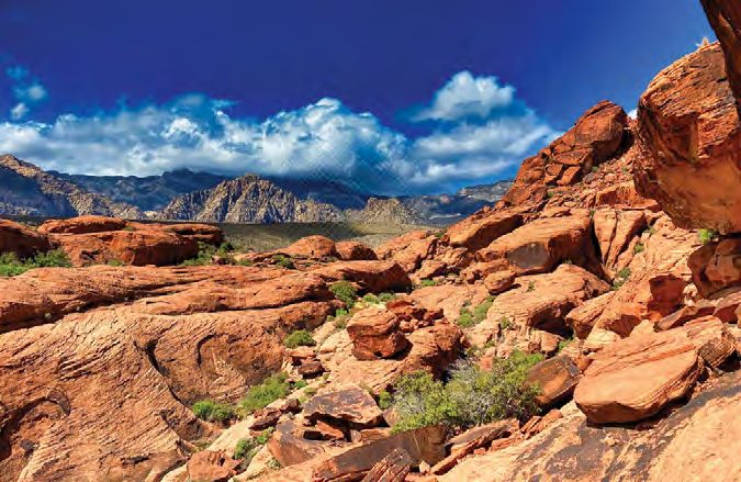
Lavé, J., and Avouac, J.P., 2000, Active folding of Murphy, M., Taylor, M., Gosse, J., Silver, C., Whipp, Yin, A., 2000, Mode of Cenozoic east-west exten-
fluvial terraces across the Siwaliks Hills, Hima- D., and Beaumont, C., 2014, Limit of strain parti- sion in Tibet suggesting a common origin of rifts
layas of central Nepal: Journal of Geophysical tioning in the Himalaya marked by large earth- in Asia during the Indo-Asian collision: Journal
Research, v. 105, no. B3, p. 5735–5770, https:// quakes in western Nepal: Nature Geoscience, v. 7, of Geophysical Research, Solid Earth, v. 105, no.
doi.org/10.1029/1999JB900292. p. 38–42, https://doi.org/10.1038/ngeo2017, B9, p. 21,745–21,759, https://doi.org/10.1029/
Leary, R.J., DeCelles, P.G., Quade, J., Gehrels, Nábělek, J., Hetényi, G., Vergne, J., Sapkota, S., 2000JB900168.
G.E., and Waanders, G., 2016, The Liuqu Con- Kafle, B., Jiang, M., Su, H., Chen, J., and Huang, Yin, A., and Taylor, M.H., 2011, Mechanics of V-
glomerate, southern Tibet: Early Miocene basin B.-S., 2009, Underplating in the Himalaya-Tibet shaped conjugate strike-slip faults and the corre-
development related to deformation within the collision zone revealed by the Hi-CLIMB ex- sponding continuum mode of continental defor-
Great Counter Thrust system: Lithosphere, v. 8, periment: Science, v. 325, no. 5946, p. 1371– mation: Geological Society of America Bulletin,
no. 5, p. 427–450, https://doi.org/10.1130/L542.1. 1374, https://doi.org/10.1126/science.1167719. v. 123, no. 9–10, p. 1798–1821, https://doi.org/
Lee, J., Hacker, B.R., Dinklage, W.S., Wang, Y., Sobel, E.R., Hilley, G.E., and Strecker, M.R., 2003, 10.1130/B30159.1.
Gans, P., Calvert, A., Wan, J.L., Chen, W.J., Formation of internally drained contractional
Blythe, A.E., and McClelland, W., 2000, Evolu- Yin, A., Harrison, T.M., Ryerson, F.J., Chen, W.J.,
basins by aridity-limited bedrock incision: Jour- Kidd, W.S.F., and Copeland, P., 1994, Tertiary
tion of the Kangmar Dome, southern Tibet: nal of Geophysical Research. Solid Earth, v. 108,
Structural, petrologic, and thermochronologic structural evolution of the Gangdese Thrust
no. B7, https://doi.org/10.1029/2002JB001883. system in southeastern Tibet: Journal of Geo-
constraints: Tectonics, v. 19, no. 5, p. 872–895, Styron, R., Taylor, M., and Sundell, K., 2015, Ac-
https://doi.org/10.1029/1999TC001147. physical Research, v. 99, p. 18,175–18,201,
celerated extension of Tibet linked to the north- https://doi.org/10.1029/94JB00504.
Lee, J., Hacker, B., and Wang, Y., 2004, Evolution
ward underthrusting of Indian crust: Nature Zeitler, P.K., Meltzer, A.S., Koons, P.O., Craw, D.,
of North Himalayan gneiss domes: Structural
Geoscience, v. 8, no. 2, p. 131, https://doi.org/
and metamorphic studies in Mabja Dome, south- Hallet, B., Chamberlain, C.P., Kidd, W.S., Park,
10.1038/ngeo2336.
ern Tibet: Journal of Structural Geology, v. 26, S.K., Seeber, L., and Bishop, M., 2001, Erosion,
Sundell, K.E., Taylor, M.H., Styron, R.H., Stockli,
no. 12, p. 2297–2316, https://doi.org/10.1016/j.jsg Himalayan geodynamics, and the geomorpholo-
D.F., Kapp, P., Hager, C., Liu, D., and Ding, L.,
.2004.02.013. gy of metamorphism: GSA Today, v. 11, no. 1,
2013, Evidence for constriction and Pliocene ac-
Lehner, B., Verdin, K., and Jarvis, A., 2008, New p. 4–9, https://doi.org/10.1130/1052-5173(2001)011
global hydrography derived from spaceborne celeration of east-west extension in the North
2.0.CO;2.
elevation data: Eos, Transactions American Lunggar rift region of west central Tibet: Tec-
Zhang, J., Yin, A., Liu, W., Wu, F., Lin, D., and
Geophysical Union, v. 89, no. 10, p. 93–94. tonics, v. 32, no. 5, p. 1454–1479, https://doi.org/
Grove, M., 2012, Coupled U-Pb dating and Hf
Liang, S., Gan, W., Shen, C., Xiao, G., Liu, J., Chen, 10.1002/tect.20086.
Taylor, M., and Yin, A., 2009, Active structures of isotopic analysis of detrital zircon of modern
W., Ding, X., and Zhou, D., 2013, Three-dimen- river sand from the Yalu River (Yarlung Tsang-
sional velocity field of present-day crustal motion the Himalayan-Tibetan orogen and their rela-
tionships to earthquake distribution, contempo- po) drainage system in southern Tibet: Con-
of the Tibetan Plateau derived from GPS mea- straints on the transport processes and evolution
surements: Journal of Geophysical Research, rary strain field, and Cenozoic volcanism: Geo-
sphere, v. 5, no. 3, p. 199–214, https://doi.org/ of Himalayan rivers: Geological Society of
Solid Earth, v. 118, no. 10, p. 5722–5732, https://
10.1130/GES00217.1. America Bulletin, v. 124, no. 9–10, p. 1449–1473,
doi.org/10.1002/2013JB010503.
Thiede, R.C., and Ehlers, T.A., 2013, Large spatial https://doi.org/10.1130/B30592.1.
Long, S., McQuarrie, N., Tobgay, T., Grujic, D., and
Hollister, L., 2011, Geologic map of Bhutan: and temporal variations in Himalayan denuda- Zhang, P.Z., Shen, Z., Wang, M., Gan, W.J., Burg-
Journal of Maps, v. 7, no. 1, p. 184–192, https:// tion: Earth and Planetary Science Letters, mann, R., and Molnar, P., 2004, Continuous de-
doi.org/10.4113/jom.2011.1159. v. 371–372, p. 278–293, https://doi.org/10.1016/ formation of the Tibetan Plateau from global
Makovsky, Y., and Klemperer, S.L., 1999, Measur- j.epsl.2013.03.004. positioning system data: Geology, v. 32, no. 9,
ing the seismic properties of Tibetan bright Whipple, K.X., Shirzaei, M., Hodges, K.V., and Ar- p. 809–812, https://doi.org/10.1130/G20554.1.
spots: Evidence for free aqueous fluids in the Ti- rowsmith, J.R., 2016, Active shortening within the
betan middle crust: Journal of Geophysical Re- Himalayan orogenic wedge implied by the 2015 M anuscript received 3 Dec. 2020
search. Solid Earth, v. 104, no. B5, p. 10,795– Gorkha earthquake: Nature Geoscience, v. 9, no. R evised manuscript received 14 M ay 2021
10,825, https://doi.org/10.1029/1998JB900074. 9, p. 711–716, https://doi.org/10.1038/ngeo2797. M anuscript accepted 19 M ay 2021
10 GSA Today | August 2021Geology in the Classroom
If you’re an educator looking for insight and inspiration to help keep you motivated,
you’ll want to check out these Special Papers from GSA. Both volumes, which are
available for download from the GSA bookstore, explore how improved understanding
of how humans think and learn about the Earth can help educators prepare the next
generation of geoscientists.
Earth and Mind: How Geologists Think and Learn about
the Earth presents essays by geoscientists, cognitive scientists,
and educators that explore how geoscientists learn and what
the implications are for student learning. (SPE413P, 188 p., ISBN
0813724139, US$9.99)
Earth and Mind II: A Synthesis of Research on Thinking and
Learning in the Geosciences explores the ways in which
geoscientists use the human senses and mind to perceive,
analyze, and explain the workings of the earth system and
how to help students master the thought processes of the
geosciences. (SPE486P, 210 p., ISBN 9780813724867, US$9.99)
Get your copy today at
https://rock.geosociety.org/storeRegistration and Information
Deadline: 11:59 p.m. MDT on 7 Sept. STUDENT VOLUNTEERS
Cancelation deadline: 11:59 p.m. MDT on 1 Oct. Earn complimentary registration when you volunteer to work
https://community.geosociety.org/gsa2021/registration for at least ten hours, plus get an insider’s view of the meeting.
Please wait to register for the meeting until you sign up as a vol-
GSA Connects 2021 registration is open. Take advantage of unteer unless you want to reserve a space in a Field Trip or Short
early registration prices and assure your spot on field trips, short Course. Details: https://community.geosociety.org/gsa2021/
courses, and events by registering now. Risk-free registration: registration/volunteers.
Fully recognizing that every individual’s situation is in flux—
between job losses, company travel freezes, etc.—GSA’s goal is to ACCOMMODATIONS & SERVICES
make it easier for you to attend GSA Connects 2021. As a result, GSA strives to create a pleasant and rewarding experience for
we have implemented a risk-free registration. Once you register, if every attendee. Let us know in advance of the meeting if you have
you are not able to attend the live event, full refunds will be avail- needs that require further attention. Most dietary considerations can
able if you cancel by 1 Oct. You can also change your registration be met without any extra charge. Be sure to check the appropriate
to the online experience and receive a refund for the difference in box when registering online, and a GSA staff member will contact
registration rates. Refund policy: The deadline to request a full you. GSA will also have a self-care room and nursing pods on site.
refund or transfer your registration to the online experience is
Friday, 1 Oct. Cancelations must be received by the stated cancel- CRITICAL HOUSING DATES
ation deadline and will be accepted in writing only. No-shows for 7 Sept.: The last day to cancel rooms without a penalty;
the event will not receive a refund. 15 Sept.: Room rates are guaranteed as long as there are rooms
available in the GSA room block;
EVENTS REQUIRING TICKETS/ 1 Oct.: All changes, cancelations, and name substitutions must be
ADVANCE REGISTRATION finalized through Connections Housing by this date; and
Several GSA Divisions and Associated Societies will hold break- After 1 Oct.: Beginning on this date, you must contact the hotel
fasts, lunches, receptions, and awards presentations that require a directly for all changes, cancelations, and new reservations.
ticket and/or advance registration (see the meeting website for a
complete list). Ticketed events are open to everyone, and tickets can Once you receive your hotel acknowledgment and have booked
be purchased in advance when you register. If you are not attending your travel, please review your hotel arrival/departure dates for
the meeting but would like to purchase a ticket to one of these accuracy. If you do not show up on the date of your scheduled
events, please contact the GSA meetings department at meetings@ arrival, the hotel will release your room and you will be charged
geosociety.org. Event space requests: 31 August is the LAST day for one night’s room and tax. If you have travel delays and cannot
to submit a request for event space and event listing. GSA will not arrive on your scheduled arrival date, please contact the hotel
assign any additional meeting space after this date and cannot guar- directly to make the hotel aware of your new arrival date.
antee to list your event on the website or mobile app. Go to https://
community.geosociety.org/gsa2021/connect/events/plan to regis- ROOM SHARING/RIDE SHARING
ter your request today. Use the GSA Roommates and Rides at https://community
.geosociety.org/gsa2021/travel/rooms-rides to share housing,
TRAVEL GRANTS airport shuttles, and/or carpool. You can also use this service to
Various groups are offering grants to help defray your costs for meet up with your colleagues at the meeting.
registration, field trips, travel, etc., for GSA Connects 2021. Check
the website at https://community.geosociety.org/gsa2021/connect/ CHILDCARE BY KIDDIECORP
student-ecp/travel-grants for application and deadline informa- KiddieCorp will provide childcare services for GSA attendees
tion. Note: Eligibility criteria and deadline dates may vary by grant. on Sun.–Wed., 7 a.m.–6 p.m. The program is open to children six
The deadline to apply for the GSA Student Travel Grant is 7 Sept. months to 12 years. The cost is US$10 per hour per child for chil-
dren two years or older and US$12 per hour per child for children
under two with a one-hour minimum per child. Register now at
https://community.geosociety.org/gsa2021/information/family.
Availability is limited and handled on a first-come, first-served
basis. Deadline: 13 Sept.
12 GSA Today | August 2021Noontime Lectures
Both presentations will also be available via live-streaming.
José Gámez Marek Ranis Missy Eppes
Tuesday, 12 Oct., 12:15–1:15 p.m.
José Gámez, Marek Ranis, Missy Eppes: “Bringing Art to Your Science and Thus Your
Science to the People: Joining Visual Culture and Scientific Evidence.” Endorsed by
GSA’s Geology and Society Division, Geoscience Education Division, History and
Philosophy of Geology Division, and Quaternary Geology and Geomorphology Division.
Description: There is a long tradition of merging art with science, originating from both
fields of study, with good reason. The idea that truth can be made visible has a long history
directly affecting both disciplines. For example, in the rise of the natural sciences in the
nineteenth century, vision was understood as a primary avenue to knowledge, and sight
takes precedence over the other senses as a primary tool in the analysis and ordering of
living things—opening doors to collaborations between artists and scientists even then.
Communication in both art and science is dependent on cooperative and collaborative meth-
ods in lab-, field-, virtual-, and three-dimensional space and time. Finally, art is perfectly
positioned to bring science to the world beyond scientists, filling a crucial need for more
effective science communication to the public. Projects merging geoscience, in particular,
with art can also serve as an effective link between natural history and human history. The
aim of this event is to provide concrete examples of how combining art with science can
serve a need for more effective science communication and to provide practical information
about how to go about it. For example, through Broader Impacts in NSF grants, there are
opportunities for earth scientists to collaborate with artists in research and pedagogy, with
the result of an enrichment of communication, understanding, and revelation.
Wednesday, 13 Oct., 12:15–1:15 p.m.
Katie Stack Morgan: “The Mars 2020 Perseverance Rover in
Jezero Crater.”
Description: The Mars 2020 Perseverance rover, NASA’s newest
flagship Mars rover mission, landed in Jezero crater in February
2021. Perseverance is seeking signs of ancient life on Mars and is
the first of a multi-mission effort to return samples from Mars back
to Earth. This talk will review highlights from the first eight
Katie Stack Morgan months of Perseverance’s mission to Mars.
www.geosociety.org/gsatoday 13GSA CONNECTS 2021
Commitment to Care
The Geological Society of America considers the safety and
well-being of all those on site at GSA Connects 2021 in Portland,
Oregon, USA, as our top priority. Our Commitment to Care is a
living document that will continue to evolve as updates become
available from the Oregon Convention Center (OCC), the Centers
for Disease Control (CDC), and local government. We are incor-
porating innovative features that will further enhance the on-site
experience and safety for everyone in attendance.
Name badges will be printed using on-demand print kiosks through-
out the pre-function area at the convention center. Seamlessly scan
your QR code, and your badge will be printed in a touchless system.
Grab a lanyard off the rack and be on your way.
On-Site Medical: We will be hiring local EMTs and providing Oregon Convention Center. Credit: Travel Portland.
a dedicated space for EMTs to meet with attendees who feel ill.
HEALTHSHIELD BY 42CHAT
Hand Sanitizer: Touchless hand sanitizer dispensers will be As part of GSA’s Commitment to Care program, GSA is intro-
placed at key guest and employee entrances, as well as in high- ducing a SMS text–based COVID-19 symptom screening. We will
use areas, such as public lobby spaces, restroom entrances, stairs, be asking attendees to click on the link that is sent via text to their
elevators, escalators, employee work areas, and offices. cell phones every morning starting on Sunday, 10 Oct., and com-
plete the three-question screening recommended by the CDC
IN PARTNERSHIP WITH THE OCC, WE WILL BE before entering the Oregon Convention Center. You can also com-
PROVIDING: plete the screening at the entrance doors of the convention center;
• Responsible food & beverage/seating/barriers for meeting spaces. however, completing it beforehand will be much faster. GSA is
• Appropriate signage/floor decals to reinforce social distancing offering this to continue to provide confidence in safety for meet-
and other safety reminders. ing attendees and to help ensure that every arriving attendee can
• Enhanced cleaning, including using electrostatic disinfectant attest to their current health status. For more information on the
sprayers in each meeting room between morning and afternoon process, go to https://www.42chat.com/bots/healthshield.
technical sessions, in addition to the OCC’s standard overnight
cleaning services. PERSONAL ACCOUNTABILITY COMMITMENT
By attending GSA Connects 2021, you agree to abide by and
The OCC has obtained the Global Biorisk Advisory Council engage in certain health-and-safety precautions while attending
(GBAC) Star Accreditation (https://gbac.issa.com/gbac-star the event. This includes, but is not limited to, wearing a mask
-facility-accreditation/). View the OCC’s Reimaged Opening & (if unvaccinated) at all times within the convention center and
Innovation Strategy for more details (https://bit.ly/2QsqzSZ [PDF]). hotels when not consuming food or beverage, minimizing face
touching, frequently washing hands, sneezing and/or coughing
into your elbow, engaging in appropriate physical distancing,
respecting others’ requests for space, and avoiding risky environ-
ments, such as overcrowded bars or restaurants. You agree to not
attend any GSA event if you feel ill or had recent exposure to a
COVID-19 case.
14 GSA Today | August 2021Scientific Field Trips Short Courses
Unique and outstanding experiences await when you attend a Earn continuing education units (CEUs) when you attend a short
field trip at GSA Connects 2021. course at GSA Connects 2021.
• Earn continuing education units (CEUs) Both online and in-person courses are available.
• Explore a new area • Learn a new topic
• Engage with colleagues and fellow geologists • Build your skills
• Learn and grow your expertise • Network
• Take courses taught by industry professionals
Register for a field trip today! Field trips will only run if
they meet the minimum number of attendees before the early Register for a short course today! Course costs go up US$30 after
registration deadline, 7 Sept. 7 Sept.
https://community.geosociety.org/gsa2021/program/field https://community.geosociety.org/gsa2021/program/short
Making
your
road 5 ye ars!
trips better for 4
OREGON ROCKS!
A Guide to 60 Amazing Geologic Sites
����� ������
Covering 60 geologic destinations, the sites
span the state’s geologic history from Triassic
marble at Oregon Caves to the 240-year-old
lava dome on Mount Hood. This guidebook
will thrill everyone who pursues outdoor
exploration in Oregon.
160 pages • 9 x 8 3⁄8 • 200 color photographs
70 color illustrations • glossary • references • index
paper $20.00 • Item 389 • ISBN 978-0-87842-703-1
NEW E
H
TO T ES!
SERI
www.geosociety.org/gsatoday 15GSA CONNECTS 2021
Geoheritage: Geology of the Community,
for the Community, by the Community
William Andrews, Kentucky Geological Survey, University of Park Service (NPS) is an obvious leader in preserving and manag-
Kentucky, Lexington, Kentucky 40506-0107, USA, wandrews@ ing Geoheritage sites (see NPS Geologic Resources Division and
uky.edu; and Renee M. Clary, Dept. of Geosciences, Mississippi American Geosciences Institute, 2015), but innumerable other
State University, Mississippi State, Mississippi 39762, USA, agencies also contribute to this critical effort. Geoheritage sites
RClary@geosci.msstate.edu can exist on widely different scales and sizes, ranging from inter-
national geoparks (McKeever et al., 2010) to state parks and local
Geoheritage identifies and seeks to protect our geodiversity nature preserves or even single outcrops. These sites can be
through geoconservation. Through a three-pronged approach, administered by either public or private entities at individual,
Geoheritage (1) acknowledges the scientific value of the geo- local, state, federal, or international levels (Fig. 2).
diversity in global localities; (2) addresses economic sustainable
development in geotourism; and (3) facilitates the educational
impact of geoscience in both informal and K–16 classroom
settings. Geoheritage makes explicit connections between our
natural and cultural heritage.
In 2012 (revised in 2017), the Geological Society of America
released its position statement on Geoheritage, supporting the
Geoheritage designation and the appropriate, respectful management
of scientifically, culturally, educationally, and/or aesthetically signifi-
cant Geoheritage sites. Currently, many GSA members engage with
sites of unique geodiversity—scientifically, economically, and/or
educationally—and participate in Geoheritage efforts, often without
an awareness of existing networks, resources, and opportunities to
integrate and optimize their impact. We endeavor to change this:
A Pardee Keynote Symposium (P3: Geoheritage: Celebrating Our
Past, Protecting Our Future) at the upcoming GSA Connects 2021 Figure 2. Geoheritage sites range from federally protected National Park
sites to smaller sites of which many local citizens are often unaware. Left:
in Portland, Oregon, USA, explores a spectrum of opportunities for Students on a field course to Yellowstone National Park enjoy Old Faithful
geoscientists and educators to professionally participate and integrate Geyser. Right: The Principles of Paleoecology course partnered with
within this exciting and bold enterprise (Fig. 1). Friends of the Black Belt Prairie and the local school board for research
and community-engaged learning within Osborn Prairie, a remnant of the
Black Belt Prairie found in Oktibbeha County, Mississippi, USA, that hosts
marine Cretaceous fossils eroding from chalk outcrops, as well as mod-
ern biodiversity in the form of disjunct and endemic species. Photographs
by Renee Clary.
Geoheritage sites serve as valuable public resources. They pro-
vide opportunities for public recreation or tourism and can have a
major impact on local economies. They also can provide a critical
educational resource through opportunities for informal and for-
mal teaching in geology, biology, ecology, and other environmen-
tal sciences, and they have the potential to increase public under-
standing and geoliteracy in critical climate and sustainability
issues facing our planet (Clary, 2021). Entire classes and curricula
can be, and have been, developed using the features and processes
visible at Geoheritage sites.
Geoheritage sites rely heavily on geologic research, both as a
Figure 1. Kentucky Geological Survey geologists lead field education and foundation for interpretation and as a basis for responsible site
professional development in the Red River Gorge Geological Area in eastern
Kentucky, USA. Photograph provided by the Kentucky Geological Survey.
management (Chan and Kamola, 2017). Also, Geoheritage sites
can provide spectacular platforms for research, using the marquee
illustrations of geologic features and phenomena often displayed
WHAT QUALIFIES AS A GEOHERITAGE SITE? at these sites. When protected and well managed, these sites can
Geoheritage sites are locations where geology can be well illus- provide a relatively secure location for longitudinal research,
trated and relevant interpretations can be communicated to the through well-documented site management and sustainable use.
public. The hope is to facilitate a deeper understanding of land- Importantly, Geoheritage sites provide a needed and highly
scapes, resources, hazards, history, and culture. The U.S. National visible platform for demonstrating inclusivity, respect, and
16 GSA Today | August 2021You can also read