A PUBLICATION OF THE GEOLOGICAL SOCIETY OF AMERICA - Double Science Issue!
←
→
Page content transcription
If your browser does not render page correctly, please read the page content below
Double
                                                                                            Science
MARCH–APRIL 2017 | VOL. 27, NO. 3–4

                                                                                            Issue!

                                      A PUBLICATION OF THE GEOLOGICAL SOCIETY OF AMERICA®

MARCH–APRIL 2017 | VOLUME 27, NUMBER 3–4
Double Science Issue!
4 Quaternary Rupture of a Crustal Fault
beneath Victoria, British Columbia, Canada
Kristin D. Morell et al.
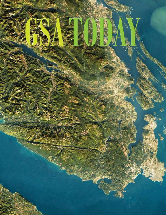
GSA TODAY (ISSN 1052-5173 USPS 0456-530) prints news Cover: Landsat 7 image of southern Vancouver Island, show-
and information for more than 26,000 GSA member readers
and subscribing libraries, with 11 monthly issues (March/
ing the surface trace of the Leech River fault and its intersec-
April is a combined issue). GSA TODAY is published by The tion with the population centers surrounding Victoria, British
Geological Society of America® Inc. (GSA) with offices at Columbia, Canada. See related article, p. 4–10.
3300 Penrose Place, Boulder, Colorado, USA, and a mail-
ing address of P.O. Box 9140, Boulder, CO 80301-9140, USA.
GSA provides this and other forums for the presentation 27 Zealandia: Earth’s Hidden Continent
of diverse opinions and positions by scientists worldwide, Nick Mortimer et al.
regardless of race, citizenship, gender, sexual orientation,
religion, or political viewpoint. Opinions presented in this Inside Cover: The St. Bathans Range, Otago, New Zealand,
publication do not reflect official positions of the Society. shows three key elements of Zealandia. The bedrock is
© 2017 The Geological Society of America Inc. All rights Mesozoic Haast Schist, a major geological unit that can be
reserved. Copyright not claimed on content prepared tracked across the continent. The flat top of the range is a
wholly by U.S. government employees within the scope of diachronous Late Cretaceous to Oligocene marine planation
their employment. Individual scientists are hereby granted
permission, without fees or request to GSA, to use a single surface that was cut as Zealandia subsided. Like the rest of the
figure, table, and/or brief paragraph of text in subsequent South Island of New Zealand, the 2000-m-high range was
work and to make/print unlimited copies of items in GSA lifted up in the Neogene in response to intracontinental
TODAY for noncommercial use in classrooms to further transpression across the Pacific-Australian plate boundary.
education and science. In addition, an author has the right
to use his or her article or a portion of the article in a thesis Image credit Lloyd Homer/GNS Science. See related article,
or dissertation without requesting permission from GSA, p. 27–35.
provided the bibliographic citation and the GSA copyright
credit line are given on the appropriate pages. For any
other use, contact editing@geosociety.org.
Subscriptions: GSA members: Contact GSA Sales & Service,
+1-888-443-4472; +1-303-357-1000 option 3; gsaservice@ 11 Elections: GSA Officers and Councilors
geosociety.org for information and/or to place a claim for
non-receipt or damaged copies. Nonmembers and institutions: 12 Call for Nominations: GSA Division Awards
GSA TODAY is US$97/yr; to subscribe, or for claims for
non-receipt and damaged copies, contact gsaservice@
geosociety.org. Claims are honored for one year; please 14 Second Announcement: 2017 GSA Cordilleran Section Meeting
allow sufficient delivery time for overseas copies. Peri-
odicals postage paid at Boulder, Colorado, USA, and at 16 GeoCareers—2017 GSA Section Meetings
additional mailing offices. Postmaster: Send address
changes to GSA Sales & Service, P.O. Box 9140, Boulder,
CO 80301-9140. 17 Penrose Conference: 250 Million Years of Earth History in Central Italy:
GSA TODAY STAFF Celebrating 25 Years of the Geological Observatory of Coldigioco
Executive Director and Publisher: Vicki S. McConnell
19 Commentary: Is it “the earth” or Earth?
Science Editors: Steven Whitmeyer, James Madison
University Dept. of Geology & Environmental Science,
800 S. Main Street, MSC 6903, Harrisonburg, VA 22807, 20 Why GSA Membership is Important to Me
USA, whitmesj@jmu.edu; Gerald Dickens, Rice University
School of Earth Science, MS-126, 6100 Main Street, 21 Call for Committee Service
Houston, Texas 77005, USA, jerry@rice.edu.
Member Communications Manager: Matt Hudson, 24 GSA 2017 Annual Meeting: Dates & Accommodations
mhudson@geosociety.org
Managing Editor: Kristen “Kea” Giles, kgiles@geosociety.org, 24 On To the Future
gsatoday@geosociety.org
Graphics Production: Margo McGrew, mmcgrew@ 25 National Park Service Geoscientists-in-the-Parks Opportunities:
geosociety.org
Fall/Winter 2017–2018
Advertising Manager: Ann Crawford,
+1-800-472-1988 ext. 1053; +1-303-357-1053; Fax: +1-303-
357-1070; advertising@geosociety.org; acrawford@ 25 GeoCorpsTM America: Fall/Winter 2017–2018
geosociety.org
GSA Online: www.geosociety.org 36 Geoscience Jobs & Opportunities
GSA TODAY: www.geosociety.org/gsatoday
Printed in the USA using pure soy inks. 37 GSA Foundation Update
39 2017 GSA Section Meetings
Quaternary Rupture of a Crustal Fault beneath Victoria,
                          British Columbia, Canada

    Kristin D. Morell, School of Earth and Ocean Sciences, University of Victoria, Victoria, British Columbia V8P 5C2, Canada, kmorell@
    uvic.ca; Christine Regalla, Department of Earth and Environment, Boston University, Boston, Massachusetts 02215, USA; Lucinda J.
    Leonard, School of Earth and Ocean Sciences, University of Victoria, Victoria, British Columbia V8P 5C2, Canada; Colin Amos,
    Geology Department, Western Washington University, Bellingham, Washington 98225-9080, USA; and Vic Levson, School of Earth
    and Ocean Sciences, University of Victoria, Victoria, British Columbia V8P 5C2, Canada

    ABSTRACT                                          detectable by seismic or geodetic monitor-                      US$10 billion in damage (Quigley et
       The seismic potential of crustal faults        ing (e.g., Mosher et al., 2000; Balfour et al.,                 al., 2012).
    within the forearc of the northern Cascadia       2011). This point was exemplified by the                           In the forearc of the Cascadia subduc-
    subduction zone in British Columbia has           2010 MW 7.1 Darfield, New Zealand                               tion zone (Fig. 1), where strain accrues due
    remained elusive, despite the recognition         (Christchurch), earthquake and aftershocks                      to the combined effects of northeast-
    of recent seismic activity on nearby fault        that ruptured the previously unidentified                       directed subduction and the northward
    systems within the Juan de Fuca Strait. In        Greendale fault (Gledhill et al., 2011). This                   migration of the Oregon forearc block
    this paper, we present the first evidence for     crustal fault showed little seismic activity                    (McCaffrey et al., 2013), microseismicity
    earthquake surface ruptures along the             prior to 2010, but nonetheless produced a                       data are sparse and do not clearly elucidate
    Leech River fault, a prominent crustal fault      30-km-long surface rupture, caused more                         planar crustal faults (Cassidy et al., 2000;
    near Victoria, British Columbia. We use           than 180 casualties, and resulted in at least                   Balfour et al., 2011). But geomorphic,
    LiDAR and field data to identify >60
    steeply dipping, semi-continuous linear
    scarps, sags, and swales that cut across                                130°W              120°W
    both bedrock and Quaternary deposits                               A.            NA                      124°W                     123°W            122°W
                                                                                                                                                         B.
                                                                50°N

    along the Leech River fault. These features                                                                  Ge
                                                                                                                   org
    are part of an ~1-km-wide and up to                                                                                ia S
    >60-km-long steeply dipping fault zone                              PA                                                 tra
                                                                                                                              it

                                                                                                                                                           49°N
    that accommodates active forearc transpres-                                                                                                   DHF
                                                                       Mw
                                                                                JF        OB
    sion together with structures in the Juan de                         4
                                                                        4-5                                                                          BCF
    Fuca Strait and the U.S. mainland.                                  5-6
                                                                        6-7                             Vancouver Island                    SPF    BB
                                                                        >7                                                                            F
    Reconstruction of fault slip across a
    deformed 1,000
    experienced at least two surface-                                            active
    rupturing earthquakes since the deglacia-                                    fault
    tion following the last glacial maximum                                       20 km                                                SF
    ca. 15 ka, and should therefore be incorpo-
    rated as a distinct shallow seismic source in
                                                                Figure 1. (A) Tectonic setting. White circles—locations of historical earth-
    seismic hazard assessments for the region.                  quakes (USGS NEIC) between AD 1946 and 2015, scaled by magnitude. White
                                                                line—boundary between Oregon Block (OB) and North America plate (NA)
    INTRODUCTION                                                (McCaffrey et al., 2013; Wells and Simpson, 2001). JF—Juan de Fuca plate;
                                                                PA—Pacific plate. (B) Population centers (Balk et al., 2006) relative to mapped
      Unlike plate boundary faults that often                   active faults in black (Sherrod et al., 2008; USGS, 2010; Kelsey et al., 2012;
                                                                Personius et al., 2014; Barrie and Greene, 2015). The Leech River fault (LRF) is
    exhibit a strong seismic or geodetic                        shown as dashed line. BBF—Birch Bay fault; BCF—Boulder Creek–Canyon
    expression (e.g., Rogers, 1988), active                     Creek fault; DDMF—Darrington–Devil’s Mountain fault; DHF—Drayton Harbor
                                                                fault; SPF—Sandy Point fault; StPF—Strawberry Point fault; SF—Seattle fault;
    faults within the adjacent crust can have                   SWF—South Whidbey Island fault; UPF—Utsalady Point fault.
    long recurrence intervals (e.g., 5–15 k.y.;
    Rockwell et al., 2000), and they may not be

    GSA Today, v. 27, no. 3–4, doi: 10.1130/GSATG291A.1

4                                                         GSA Today | March–April 2017
A.                         124°W
                                                 JKLe
                                                             123°45'W             123°30'W                              B.
            Leech River Fault                                           Sooke Lake dam

                                                                                                        48°30'N
                                                                                          Wrangellia
          Sombrio Pt.                        Hydroelectric
                                             plant dams
                                                                    Par
                                                                        t   sC                 Victoria
          N Juan                                              EMe             &D
                 de
                        Fuc
                           a   Stra               EOCa
                                                                                                                                                   75
                                                                                                                                                           N
              10 km                 it                                                   DDMF; Barrie and
                                                                                         Greene, 2015                   Mylonitic fabric

         C.                                                                      45
                                                                                                   60
                         JKLe                Site B
              30                                                                         Site C                                            Qa.
                               75                       50                                                        71          45
                         25              90                                                                                                Colwood Delta
               Site A                                                                     52
              2 km                       N                              EMe                            30
                                                                                                                       20

         D.

                                             Site B
              Site A                                                                    Site C
              2 km                       N
               Quat. deposits, undiff. (Qa)                             Mapped fault Ice flow                                South-facing scarp or bench
               Eoc.-Olig. Carmanah Grp. (EOCa)                              Observed       lidar-derived                     Linear swale or sag
               Eoc. Metchosin Fm. (EMe)                                     Inferred       striae
               Jur.-Cret. Leech River Complex and                           Covered     Foliation                            North-facing scarp or bench
               Pandora Peak Unit (JKLe)
                                                                        Topographic scarp                                    Probable scarp
               Wrangellia terrane, undiff.

         Figure 2. (A) Simplified geologic map of the Leech River fault and surroundings (after Massey et al., 2005). Red lines denote topo-
         graphic scarps, pressure ridges, topographic benches, and linear swales and sags identified in this study. See geological legend at
         base of figure. DDMF—Darrington–Devil’s Mountain fault. (B) Mylonitic fabrics within the Leech River Complex near its contact with
         the Metchosin Fm. (C) Map showing trace of identified features relative to bedrock (Massey et al., 2005), surficial deposits (Blyth and
         Rutter, 1993), and local ice flow indicators (blue arrows, this study). Foliation measurements from this study are shown in bold and
         those from Muller (1983) are shown in italics. Foliation data outlined in white are at the lithologic contact (this study). (D) Fault traces
         as in part C, colored according to facing direction and feature type, draped on LiDAR hillshade image.

trenching, and geophysical studies have                       the seismic hazard it may pose to the nearby                  activity is also recognized 10–20 km
proven successful at highlighting a net-                      population of Victoria, British Columbia                      offshore of the Leech River fault along a
work of oblique reverse forearc faults, both                  (Figs. 1 and 2A) (see Cassidy et al., 2000;                   structure in the Juan de Fuca Strait (Barrie
on- and offshore of Washington and                            Mosher et al., 2000; Balfour et al., 2011).                   and Greene, 2015) (Figs. 1 and 2A), but
Oregon, that can produce earthquakes up                       Several previous authors suggest that this                    direct evidence for recent rupture onshore
to 7.5 in magnitude (McCaffrey and                            fault, which places Jurassic-Cretaceous                       has remained ambiguous.
Goldfinger, 1995; ten Brink et al., 2006;                     schists of the Leech River Complex to                            Here, we use a combination of techniques
Blakely et al., 2014; Sherrod et al., 2016).                  the north against Eocene basalts of the                       to delineate Quaternary fault-related fea-
In particular, LiDAR, seismic, and aero-                      Metchosin Formation to the south (Fig. 2A)                    tures along the Leech River fault, including
magnetic data have been paramount in the                      (Fairchild and Cowan, 1982; Rusmore and                       (1) mapping of fault scarps from hillshade
recognition of the Seattle fault as a signifi-                Cowan, 1985), was last active in the                          and local slope images generated from a
cant seismic hazard source within the                         Eocene (MacLeod et al., 1977; Johnston                        high resolution (~2 m horizontal by ~10 cm
greater Seattle region (SF, Fig. 1) (Johnson                  and Acton, 2003). Yet, trenching, coring,                     vertical) LiDAR digital elevation model
et al., 1999; Blakely et al., 2002; Kelsey et                 and geophysical studies indicate multiple                     (DEM) collected by Natural Resources
al., 2008; Nelson et al., 2014).                              Quaternary ruptures of adjacent fault sys-                    Canada (James et al., 2010); (2) first-order
   The potential Quaternary activity of                       tems in Washington state, USA, including                      bedrock and surficial field mapping;
the Leech River fault, an ~60-km-long                         the Southern Whidbey Island fault, the                        (3) collection of detailed structural and
terrane-bounding fault in the southern                        Utsalady Point fault, and the Darrington–                     geomorphic data at key sites; and (4) com-
Vancouver Island forearc (Muller, 1977;                       Devil’s Mountain fault (Fig. 1) (Johnson et                   pilation of our observations with data from
MacLeod et al., 1977), has drawn signifi-                     al., 1996, 2001; Sherrod et al., 2008;                        previous studies (e.g., Fairchild and
cant attention in recent years because of                     Personius et al., 2014). Quaternary seismic                   Cowan, 1982; Blyth and Rutter, 1993;

                                                                    www.geosociety.org/gsatoday                                                                            5
B
30
P1 VS = 5.7 ± 1.7 m
A
Height (m)
VS
ce
N
20
a
downhill surf
ial
lluv
co
l
P1 ne
10
an P2
ch
Colluvial VS = 3.2 ± 1.2 m
apron P2 N S
-40 -20 0 20 40
Distance (m)
View to N
C
Channel
margin Channel
bottom
uphill
100 m Scarp
Bedrock face
Figure 3. (A) LiDAR hillshade map of Site A, showing an uphill (south) facing scarp cutting the surface of a steeply north-
sloping colluvial apron and channels. Red arrows point to steep face. Black and white arrows show apparent left and right
(respectively) lateral separations of channel margins. Example profile lines (P1 and P2) locations shown. Additional profile
lines are shown in Figure DR2 (see text footnote 1). (B) An example of LiDAR-derived elevation profiles from interfluve P1 and
channel P2. VS—vertical separation. (C) Field photo showing tectonic scarp in a channel at site C.
Massey et al., 2005). We identify several along steeply dipping foliation planes, we differential erosion across this strong litho-
strands of the Leech River fault that dis- mapped the position of lithologically dis- logic contrast.
place post-glacial sediments and record at tinct units and collected structural data on To further exclude topographic features
least two MW >6 earthquakes since the the occurrence and orientation of foliation produced by glacial processes, we deter-
Cordilleran deglaciation ca. 15 ka (Clague and fault deformation fabrics. The topo- mined local ice flow directions from bed-
and James, 2002). These data provide the graphic scarps we identified are roughly rock striae and streamlined glacial deposits
first evidence for Quaternary surface rup- parallel to the previously mapped location and collected geomorphic data designed
ture along a crustal fault that lies within of the Leech River fault (Fairchild and to confirm a tectonic origin. The roughly
close proximity of Victoria, British Cowan, 1982; Massey et al., 2005), but east-west–oriented topographic features on
Columbia, and suggest that the Leech River none of the identified fault scarps coincide the eastern half of the Leech River fault
fault is only one of a network of active exactly with the fault contact between the are nearly perpendicular to the southerly
faults that accommodate forearc deforma- Leech River Complex and the Metchosin regional ice flow direction during the last
tion in southwestern Canada. Formation (Fig. 2). Instead, individual top- glacial maximum. The LiDAR data delin-
ographic features occur both north and eate large (km-long) drumlinoid ridges
OBSERVATIONS south of the lithologic fault boundary by with well-defined apices that are distinc-
We mapped >60 topographic features as much as hundreds of meters. Where a tively streamlined with steep up-ice (north-
along the Leech River fault that together discrete contact between the basalt and ern) margins and upper surfaces
extend >60 km in length and span ~1 km in schist units is exposed at two locations that gently slope in a southerly, down-ice
width. Individual features range in length in the area, the fault strikes parallel to direction (Figs. 2C and 2D). Our field work
from hundreds of meters to >2.5 km, reach regional foliation (300–310°) but dips more confirms that these ridges are mantled by
up to ~5 m in height, and form linear ridges, steeply (70–90° NE) than the foliation glacial sediments (Fig. DR1E
sags, and scarps with both north- and (~45° NE) (Figs. 2B and 2C, and GSA [see footnote 1]). South-directed ice flow is
south-facing directions (Fig. 2). Along the Data Repository1 Fig. DR1A). The western- further supported by glacial striae data
eastern half of the fault, where we focused most of these sites contains a 10- to on bedrock near the drumlinoid ridges
our analysis, these topographic features >200-m-wide mylonitic shear zone within (Fig. 2C). The observation that the mapped
coincide with displaced geomorphic sur- both units, but exhibits no brittle deforma- scarps strike perpendicular to the ice
faces, steeply dipping brittle faults, and tion at the outcrop scale (Figs. 2B flow direction rules out their formation
uphill-facing bedrock scarps. and 2C). Because the mapped features do by ice flow–parallel processes, including
In order to exclude topographic features not coincide with the lithologic terrane glacial scouring, grooving, molding,
that were produced by differential erosion boundary, they cannot be explained by and streamlining.
1
GSA Data Repository Item 2017046, supplementary figures, is online at http://www.geosociety.org/datarepository/2017/. If you have questions, please email
gsatoday@geosociety.org.
6 GSA Today | March–April 2017
A

          Leech R.                                                           B1
                       Bedrock                                                                                                                    B2

                                                                                      e R.
                                                                                  Sook
                                                                 fa
                   N                                                ul
                                                                         t                                                                    P3
           100 m                                                 slick

           B                                            C                                                                                     200 m

                                                                             P4                                                          P5
                                      slickenside
                                                                   Till                                                           Till

                                                                                               Bedrock
                                                               N
                                                                                          P4                                       P5         S

                                                                                                         Height (m)
                           bedrock               P3

                                                                                                          -5 0 5
          Height (m)
          -10 0 10

                                                                         N                       S                    N
                                                            Height (m)
                                                             -5 0 5

                                     sediments

                                                                                  U   D                                       D    U
                       N                          S
                  -30 -15    0     15             30                  -80 -40   0 40             80              -60 -30   0 30 60
                        Distance (m)                                       Distance (m)                              Distance (m)
         Figure 4. (A) LiDAR hillshade image for site B where there is a >1.5-km-long scarp in bedrock. Red arrows point to steep face. Ste-
         reonet from fault at site B1. (B) Field photo of gouge-bearing fault at site B1, with subhorizontal slickenlines. Elevation profile at
         bottom for site B2. (C) LiDAR hillshade for site C showing topographic features with opposing facing directions and a morphology
         suggestive of pressure ridges. Red arrows point to the steep face. LiDAR-derived elevation profiles shown below the image.
         Because structures are buried beneath dense vegetation and glacial till, fault locations are inferred (dashed lines on the profiles).
         U and D denote up- and downthrown sides, respectively.

FIELD EVIDENCE FOR TECTONIC                            channels littered with boulders incise this                    (Fig. DR2). These estimates support our
SCARPS                                                 colluvial apron.                                               field observations of a differential amount
  We identify three key sites (Figs. 2C and               LiDAR and field data indicate that both                     of displacement across the scarp between
                                                       the colluvial surface and the channels                         channels versus interfluves (Fig. 3C).
2D, sites A–C) where field and LiDAR data
                                                       incising it are vertically displaced by sev-                      Several field observations suggest this
indicate tectonic displacement of bedrock
                                                       eral meters across the scarp (~3–6 m)                          scarp reflects north-side-up dip slip dis-
and Quaternary deposits.
                                                       (Figs. 3 and DR1B [see footnote 1]). We                        placement along a steeply north-dipping
Site A                                                 calculated vertical separations at 12 loca-                    (60–90°) fault. For instance, the interac-
                                                       tions across the fault scarp by linear                         tion of the scarp with local topography
   Near the center of the Leech River fault,           regression of LiDAR-derived topography                         suggests that the fault dips steeply to the
the LiDAR data reveal a >200-m-long and                and estimated regression uncertainties                         north; the scarp trace is nearly linear in
up to ~3–6-m-high topographic scarp that               using a Monte Carlo routine (following                         map view, but it deviates slightly north-
faces uphill (southward) across a relatively           Thompson et al., 2002) (Fig. DR2 [see                          ward into topographic lows (Fig. DR2A).
steep (~20°), north-facing slope (Fig. 3A).            footnote 1]). These data confirm that scarp                    Additionally, both the apparent north-side-
Beneath an ~1-m-thick mantle of collu-                 height is systematically lower within the                      up displacement and the spatial pattern of
vium at the surface, the hillside consists             incised channels than on the colluvial sur-                    channel displacement indicate dip slip
of a dense, matrix-supported diamict with              face. For example, at interfluve P1, the                       displacement with little to no lateral dis-
numerous erratics and striated clasts,                 vertical separation across the scarp                           placement. While northeast-trending
interpreted as subglacial till. These field            approaches ~6 m (5.7 ± 1.7 m) (Fig. 3B). At                    channels show apparent right separation
observations, the relatively smooth surface            channel P2, however, the LiDAR profiles                        (white arrows, Fig. 3A), north-northwest–
morphology, and the lack of a fan apex,                indicate only ~3 m (3.2 ± 1.2 m) of vertical                   trending channels show apparent left
indicate that this ~400-m-long by                      separation. On average, the interfluves are                    separation (black arrows, Fig. 3A).
~300-m-wide hillside is covered by an                  vertically separated by 5.7 ± 1.3 m (n = 8)                    Together, these data indicate that both the
apron of colluvium. Several steep, linear              and the channels by 3.9 ± 0.9 m (n = 4) (1s)                   colluvial surface and the channels have

                                                              www.geosociety.org/gsatoday                                                                           7
been vertically displaced by ~4–6 m due to increase in surface elevation. We interpret We suggest that the identified scarps
slip on a steep, north-dipping reverse fault. this en echelon arrangement of topo- together compose an active fault system
graphic ridges and the lateral juxtaposi- that is up to ~1 km wide and 30–60 km
Site B tion of topographic highs and lows as long (Fig. 2A). Although individual linea-
Five kilometers east along strike from pressure ridges, common in strike slip or ments can be traced for only hundreds of
site A, a prominent south-facing bedrock oblique slip systems (e.g., Sylvester, meters along strike, meter-high fault scarps
scarp extends for ~1.5 km and shows evi- 1988; Sherrod et al., 2008, 2016; Nelson are not easily preserved in this wet climate,
dence for brittle deformation along its et al., 2014). and the fault scarps are semi-continuous
length (site B, Figs. 2 and 4). Near the cen- with one another along strike. Our recog-
ter of this scarp, an abandoned rock QUATERNARY SLIP ON THE nition of topographic features along the
quarry exposes two steeply north-dipping LEECH RIVER FAULT western ~30 km of the fault similar to
sub-parallel faults (dipping 85° to N40°E) The displaced geomorphic features, those on the eastern half (Fig. 2C) suggests
cutting Metchosin Formation basalt (site faulted bedrock, and prominent scarps that the active fault zone extends the entire
B1, Figs. 4A and 4B). Both faults have a collectively argue that several strands of 60-km length of the fault onshore (Fig.
1–2-mm-wide gouge zone and exhibit sub- the Leech River fault have been active 2A). Scarp morphology, fault orientations,
horizontal slickenlines (05° toward 129°) since the late Pleistocene. Our observa- and fault kinematics suggest that the active
consistent with strike-slip motion (Figs. tions support a tectonic genesis for the strands of the Leech River fault accommo-
4B and DR1C [see footnote 1]). At the topographic features we identify for sev- date strike and dip slip motion within a
eastern end of site B, the scarp becomes eral reasons. First, several of the identified steeply dipping fault zone or flower struc-
~4 m high and uphill facing (Fig. 4A). topographic features show evidence for ture. Within a zone up to 1 km wide, we
Here, the northern (upthrown) side of the extensive brittle faulting. For example, the observe near vertical faults, variable scarp
scarp consists of fractured and brittly fractured rock and gouge along the scarp facing directions, laterally discontinuous
deformed Metchosin Formation basalt, at site B (Fig. 4B) require a tectonic origin surface scarps, and field evidence for
whereas the southern (downthrown) side and exclude formation by either ice pluck- strike-slip and reverse faulting. These
of the scarp contains fine-grained sedi- ing or the erosion of a bedrock foliation. characteristics are typical of strike slip
ment (P3, Fig. 4B). Similar to site A, the Second, the observation that paleo–ice systems and are similar to features
apparent north-side-up displacement flow was directed to the south, at a high observed along active oblique-reverse
across the scarp and the northward diver- angle to the orientation of the topographic faults in the adjacent Pacific Northwest
gence of the scarp trace into topographic features (Fig. 2C), further rules out forma- (e.g., Johnson et al., 2001; Sherrod et al.,
lows signifies dip displacement along a tion by glacial processes. Finally, it is 2008, 2016; Kelsey et al., 2012; Nelson et
steeply north-dipping reverse fault (Figs. unlikely that the topographic scarps in al., 2014; Personius et al., 2014; Blakely et
4B and DR1D). Overall, these observa- Quaternary deposits were produced by al., 2014).
tions suggest an origin for this feature as a landslide processes. Several of the scarps, These new results challenge the pre
tectonic scarp. including those at sites A and B (Figs. 2C vailing view that the Leech River fault was
and 2D), are uphill facing, nearly perfectly primarily an Eocene structure (cf.
Site C linear, and do not exhibit curvilinear head MacLeod et al., 1977). This interpretation
Approximately 5 km east of site B, an scarps that would be expected for landslides. was partly based on the observation that
~1.5-km-long region contains >300-m-long The most compelling evidence for a tec- relatively undeformed Oligocene sedi-
ridges, linear sags, and swales up to tonic origin for these topographic features ments of the Carmanah Group (Sooke
~2–5 m in height that cut across relatively comes from site A, where both the hillslope Fm.) lie unconformably above healed frac-
smooth, gently sloping till-mantled hill- surface and multiple channels are displaced tures and mylonitic fabrics close to the
slopes (Figs. 4C and DR1E). These topo- vertically along an uphill facing scarp trace of the Leech River fault near Sombrio
graphic features display several differ- (Figs. 3A and 3B). The scarp at site A can- Point (Fig. 2A) (MacLeod et al., 1977).
ences from those at sites to the west. not represent the remnants of an abandoned However, our results from the eastern half
Whereas sites A and B exhibit discrete logging road or placer mining excavation of the Leech River fault show that active
topographic scarps, features in this region because the base of the scarp is not graded, fault strands occur within a zone as much
are 10–15-m-wide elevated zones that sit and the upper and lower surfaces are verti- as 1 km wide and these strands are not
more than ~5 m above the surrounding cally separated by >~4 m (Fig. 3B). Such always co-located with observed fault-
landscape. Moreover, while the scarps displacement in hillslope elevation, and in related fabrics. Therefore, the location of
at sites A and B remain north-facing for particular the displaced channels, cannot fault fabrics may not coincide with the
hundreds of meters along strike, the facing be produced by any mechanism other than surface trace of the active fault.
direction of the features in site C transi- fault displacement. Because the colluvial
apron at this site remains both in situ and IMPLICATIONS FOR
tions southeastward from south-
intact, the tectonic scarps crosscutting the PALEOSEISMICITY
to north-facing over a short (~200 m)
distance (Figs. 2D and 4C). colluvial surface and inset channels must The displaced channels and colluvial
These scarps have a nearly linear trace be no older than the deglaciation following surface at site A suggest this section of the
across topography, but they do not exhibit the last glacial maximum (ca. 15 ka) Leech River fault has experienced at least
clear upthrown fault blocks or a marked (Clague and James, 2002). two, and possibly three or more, large,
8 GSA Today | March–April 2017
surface-rupturing earthquakes since the ongoing tectonic strain in the forearc of the Bulletin, v. 114, no. 2, p. 169–177, doi: 10.1130/
formation of the surface ca. 15 ka. For a active Cascadia subduction zone. 0016-7606(2002)1142.0.CO;2.
Blakely, R.J., Sherrod, B.L., Weaver, C.S., Wells,
60–90° reverse fault, the displacements R.E., and Rohay, A.C., 2014, The Wallula fault
across the scarp require minimum dip IMPLICATIONS FOR SEISMIC and tectonic framework of south-central
displacements of 6.4 ± 1.5 m for inter- HAZARD Washington, as interpreted from magnetic and
fluves (n = 8) and 4.4 ± 1.1 m for channels The length of the active Leech River gravity anomalies: Tectonophysics, v. 624–625,
(n = 4). The ~2 m difference in displace- p. 32–45, doi: 10.1016/j.tecto.2013.11.006.
fault zone (30–60 km; Fig. 2A) and its Blyth, H., and Rutter, N., 1993, Surficial geology
ment between the channels and interfluves history of multiple Quaternary ruptures of the Sooke area (nts 92b/5): British Columbia
implies multiple episodes of fault activity suggest it is capable of producing earth- Ministry of Energy Mines and Petroleum
and suggests that at least one event with quakes of MW >6. This active fault zone Resources, Open File 1993-25.
~2 m displacement occurred after the for- Cassidy, J.F., Rogers, G.C., and Waldhauser, F.,
lies within tens of kilometers of down-
2000, Characterization of active faulting
mation of the colluvial apron but before town Victoria and in close proximity to beneath the Strait of Georgia, British Columbia:
channel incision. In addition to this early three local water dams. One of these dams Bulletin of the Seismological Society of
event, the ~4 m of displacement of the is located within 2 km of the active fault America, v. 90, no. 5, p. 1188–1199, doi: 10.1785/
channels (Fig. 3B and DR2 [see footnote zone and supports the region’s principal 0120000044.
1]) requires either one large event with Clague, J.J., and James, T.S., 2002, History and
water supply reservoir (Fig. 2A). The other
isostatic effects of the last ice sheet in southern
~4 m of slip, or multiple smaller events two dams lie within the active fault zone British Columbia: Quaternary Science Reviews,
that together sum to ~4 m of slip. Global and support a hydroelectric power plant. v. 21, no. 1–3, p. 71–87, doi: 10.1016/S0277-3791
empirical relationships suggest that sur- Thus, our new identification of a signifi- (01)00070-1.
face displacements on the order of meters cant shallow seismic source has consider- Fairchild, L., and Cowan, D., 1982, Structure,
correspond to earthquakes of MW 6 or petrology, and tectonic history of the Leech
able implications for the seismic risk River complex northwest of Victoria, Vancouver
greater (e.g., Wells and Coppersmith, 1994). exposure of this populated region. Island: Canadian Journal of Earth Sciences,
Surface-rupturing earthquakes with shal- v. 19, p. 1817–1835, doi: 10.1139/e82-161.
IMPLICATIONS FOR REGIONAL low hypocenters can be highly destruc- Gledhill, K., Ristau, J., Reyners, M., Fry, B., and
SEISMOTECTONICS tive, and it is therefore important that the Holden, C., 2011, The Darfield (Canterbury,
New Zealand) MW 7.1 earthquake of September
Several observations indicate the active Leech River fault zone be incorporated 2010: A preliminary seismological report:
Leech River fault zone is part of a network into seismic hazard assessments of south- Seismological Research Letters, v. 82, no. 3,
of high-angle oblique faults that accom western British Columbia and neighboring p. 378–386, doi: 10.1785/gssrl.82.3.378.
modate regional transpression across the regions. Hetzel, R., and Hampel, A., 2005, Slip rate variations
on normal faults during glacial–interglacial
Juan de Fuca Strait and Puget Sound region.
ACKNOWLEDGMENTS changes in surface loads: Nature, v. 435, 7038,
Barrie and Greene (2015) trace the Devil’s p. 81–84, doi: 10.1038/nature03562.
Mountain fault of Washington state, USA, We thank CRD watersheds and BC Hydro for James, T., Bednarski, J., Rogers, G., and Currie, R.,
to within 10–20 km of the fault scarps on access to key field sites. This manuscript benefit- 2010, LiDAR and digital aerial imagery of the
Fig. 2, and their bathymetric and seismic ted from comments by Jack Loveless, Alan Nelson, Leech River Fault Zone and coastal regions
Christie Rowe, and two anonymous reviewers. from Sombrio Point to Ten Mile Point, southern
surveys reveal a steeply dipping oblique
We thank Steven Whitmeyer for editorial han- Vancouver Island, British Columbia: Geological
-slip fault zone similar to our observations dling. This research was supported by an NSERC Survey of Canada, Open-File 6211, doi: 10.4095/
of the Leech River fault zone. Both the Discovery grant to KM and NSF EAR IRFP Grant 285486.
Darrington–Devil’s Mountain fault and #1349586 to CR. Johnson, S., Potter, C., Miller, J., Armentrout, J.,
the Southern Whidbey Island fault systems Finn, C., and Weaver, C., 1996, The southern
Whidbey Island fault: An active structure in the
of Washington state (Fig. 1) are likewise REFERENCES CITED
Puget Lowland, Washington: GSA Bulletin,
near-vertical fault zones with oblique slip Balfour, N., Cassidy, J., Dosso, S., and Mazzotti, v. 108, p. 334–354, doi: 10.1130/0016-7606(1996)
histories (Sherrod et al., 2008; Personius et S., 2011, Mapping crustal stress and strain in 1082.3.CO;2.
al., 2014) similar to many of the crustal southwest British Columbia: Journal of Johnson, S., Dadisman, S., Mosher, D., Blakely,
Geophysical Research: Solid Earth (1978–2012), R., and Childs, J., 2001, Active tectonics of the
fault systems throughout the Puget Sound
v. 116, B03314, doi: 10.1029/2010JB008003. Devil’s Mountain Fault and related structures,
region (e.g., McCaffrey and Goldfinger, Balk, D., Deichmann, U., Yetman, G., Pozzi, F., Northern Puget Lowland and Eastern Strait of
1995; ten Brink et al., 2006; Blakely et al., Hay, S., and Nelson, A., 2006, Determining Juan de Fuca Region, Pacific Northwest: U.S.
2014; Nelson et al., 2014; Sherrod et al., global population distribution: Methods, Geological Survey Professional Paper 1643.
2016). Considering these similarities in applications and data: Advances in Parasitology, Johnston, S.T., and Acton, S., 2003, The Eocene
v. 62, p. 119–156, doi: 10.1016/S0065-308X(05) Southern Vancouver Island Orocline: A response
orientation and slip sense, we suggest that 62004-0. to seamount accretion and the cause of fold-and-
the Leech River fault is part of this regional Barrie, V., and Greene, G., 2015, Active faulting in thrust belt and extensional basin formation:
active forearc fault system. Although it the northern Juan de Fuca Strait, Implications Tectonophysics, v. 365, no. 1–4, p. 165–183,
remains possible that the timing of past for Victoria, British Columbia: Geological doi: 10.1016/S0040-1951(03)00021-0.
ruptures along these fault systems was Survey of Canada Current Research 2015-6, Johnson, S.Y., Dadisman, S.V., Childs, J.R., and
p. 10, doi: 10.4095/296564. Stanley, W.D., 1999, Active tectonics of the
influenced by stress loading or release Blakely, R.J., Wells, R.E., Weaver, C.S., and Seattle fault and central Puget Sound,
related to the last glaciation (e.g., Hetzel and Johnson, S.Y., 2002, Location, structure, and Washington—Implications for earthquake hazards:
Hampel, 2005), repeated earthquakes on seismicity of the Seattle fault zone, Washington: GSA Bulletin, v. 111, no. 7, p. 1042–1053,
crustal faults including the Leech River Evidence from aeromagnetic anomalies, geologic doi: 10.1130/0016-7606(1999)1112.3.CO;2.
should be expected in order to accommodate
www.geosociety.org/gsatoday 9
Kelsey, H.M., Sherrod, B.L., Nelson, A.R., and         Muller, J., 1983, Geology of Victoria map-area:        Sherrod, B., Blakely, R., Weaver, C., Kelsey, H.,
       Brocher, T.M., 2008, Earthquakes generated             Geological Survey of Canada, “A” Series Map             Barnett, E., Liberty, L., Meagher, K., and Pape,
       from bedding plane-parallel reverse faults above       1553A, 1 sheet, scale: 1:100,000 doi: 10.4095/          K., 2008, Finding concealed active faults:
       an active wedge thrust, Seattle fault zone: GSA        119507.                                                 Extending the southern Whidbey Island fault
       Bulletin, v. 120, no. 11–12, p. 1581–1597, doi:      Nelson, A.R., Personius, S.F., Sherrod, B.L.,             across the Puget Lowland, Washington: Journal
       10.1130/B26282.1.                                      Kelsey, H.M., Johnson, S.Y., Bradley, L.A., and         of Geophysical Research, v. 113, B05313, doi:
     Kelsey, H.M., Sherrod, B.L., Blakely, R.J., and          Wells, R.E., 2014, Diverse rupture modes for            10.1029/2007JB005060.
       Haugerud, R.A., 2012, Holocene faulting in the         surface-deforming upper plate earthquakes in         Sherrod, B.L., Blakely, R.J., Lasher, J.P., Lamb, A.,
       Bellingham forearc basin: Upper-plate                  the southern Puget Lowland of Washington                Mahan, S.A., Foit, F.F., and Barnett, E.A., 2016,
       deformation at the northern end of the Cascadia        State: Geosphere, v. 10, no. 4, p. 769–796, doi:        Active faulting on the Wallula fault zone within
       subduction zone: Journal of Geophysical                10.1130/GES00967.1.                                     the Olympic-Wallowa lineament, Washington
       Research, Solid Earth, v. 117, B03409, doi:          Personius, S.F., Briggs, R.W., Nelson, A.R.,              State, USA: GSA Bulletin, v. 128, no. 11–12,
       10.1029/2011JB008816.                                  Schermer, E.R., Maharrey, J.Z., Sherrod, B.L.,          p. 1636–1659, doi: 10.1130/B31359.1.
     MacLeod, N., Tiffin, D., Snavely, P., Jr., and           Spaulding, S.A., and Bradley, L.A., 2014,            Sylvester, A.G., 1988, Strike-slip faults: GSA Bulletin,
       Currie, R., 1977, Geologic interpretation of           Holocene earthquakes and right-lateral slip on          v. 100, no. 11, p. 1666–1703, doi: 10.1130/0016
       magnetic and gravity anomalies in the Strait of        the left-lateral Darrington–Devils Mountain             -7606(1988)1002.3.CO;2.
       Juan de Fuca, U.S.–Canada: Canadian Journal            fault zone, northern Puget Sound, Washington:        ten Brink, U., Song, J., and Bucknam, R.C., 2006,
       of Earth Sciences, v. 14, no. 2, p. 223–238, doi:      Geosphere, v. 10, no. 6, p. 1482–1500, doi:             Rupture models for the AD 900–930 Seattle
       10.1139/e77-024.                                       10.1130/GES01067.1.                                     fault earthquake from uplifted shorelines:
     Massey, N.W.D., MacIntyre, D., Desjardins, P., and     Quigley, M., Van Dissen, R., Litchfield, N.,              Geology, v. 34, no. 7, p. 585–588, doi: 10.1130/
       Cooney, R., 2005, Digital geology map of British       Villamor, P., Duffy, B., Barrell, D., Furlong, K.,      G22173.1.
       Columbia: BC Ministry of Energy and Mines,             Stahl, T., Bilderback, E., and Noble, D., 2012,      Thompson, S.C., Weldon, R.J., Rubin, C.M.,
       Geological Survey Branch, scale: 1:250,000.            Surface rupture during the 2010 MW 7.1                  Abdrakhmatov, K., Molnar, P., and Berger,
     McCaffrey, R., and Goldfinger, C., 1995, Forearc         Darfield (Canterbury) earthquake: Implications          G.W., 2002, Late Quaternary slip rates across
       deformation and great subduction earthquakes:          for fault rupture dynamics and seismic-hazard           the central Tien Shan, Kyrgyzstan, central Asia:
       Implications for Cascadia offshore earthquake          analysis: Geology, v. 40, no. 1, p. 55–58, doi:         Journal of Geophysical Research, Solid Earth,
       potential: Science, v. 267, 5199, p. 856–859,          10.1130/G32528.1.                                       v. 107, no. B9, doi: 10.1029/2001JB000596.
       doi: 10.1126/science.267.5199.856.                   Rockwell, T., Lindvall, S., Herzberg, M., Murbach,     USGS, 2010, Quaternary fault and fold database
     McCaffrey, R., King, R.W., Payne, S.J., and              D., Dawson, T., and Berger, G., 2000, Paleo-            for the United States: http//earthquakes.usgs.
       Lancaster, M., 2013, Active tectonics of               seismology of the Johnson Valley, Kickapoo,             gov/hazards/qfaults/ (last accessed April 2015).
       northwestern U.S. inferred from GPS-derived            and Homestead Valley faults: Clustering of           Wells, D.L., and Coppersmith, K.J., 1994, New
       surface velocities: Journal of Geophysical             earthquakes in the eastern California shear zone:       empirical relationships among magnitude, rupture
       Research, Solid Earth, v. 118, p. 709–723, doi:        Bulletin of the Seismological Society of                length, rupture width, rupture area, and surface
       10.1029/2012JB009473.                                  America, v. 90, no. 5, p. 1200–1236, doi:               displacement: Bulletin of the Seismological
     Mosher, D.C., Cassidy, J.F., Lowe, C., Mi, Y.,           10.1785/0119990023.                                     Society of America, v. 84, no. 4, p. 974–1002.
       Hyndman, R.D., Rogers, G.C., and Fisher, M.,         Rogers, G.C., 1988, An assessment of the megathrust    Wells, R., and Simpson, R., 2001, Northward mi-
       2000, Neotectonics in the Strait of Georgia:           earthquake potential of the Cascadia subduction         gration of the Cascadia forearc in the northwestern
       First tentative correlation of seismicity with         zone: Canadian Journal of Earth Sciences, v. 25,        U.S. and implications for subduction deformation:
       shallow geological structure in southwestern           no. 6, p. 844–852, doi: 10.1139/e88-083.                Earth, Planets and Space, v. 53, p. 275–283, doi:
       British Columbia: Current Research, p. A22.          Rusmore, M.E., and Cowan, D.S., 1985, Jurassic-           10.1186/BF03352384.
     Muller, J.E., 1977, Evolution of the Pacific Margin,     Cretaceous rock units along the southern edge
       Vancouver Island, and adjacent regions: Canadian       of the Wrangellia terrane on Vancouver Island:       M ANUSCRIPT RECEIVED 28 M ARCH 2016
       Journal of Earth Sciences, v. 14, no. 9, p. 2062–      Canadian Journal of Earth Sciences, v. 22, no. 8,    R EVISED MANUSCRIPT RECEIVED 20 JUNE 2016
       2085, doi: 10.1139/e77-176.                            p. 1223–1232, doi: 10.1139/e85-124.                  M ANUSCRIPT ACCEPTED 6 JULY 2016

          The Web of Science’s #1 ranked geology journal for 10 years in a row.

                                   FREE online access to every
                                Geology issue is now included with
                                   all 2017 GSA Memberships.

      Not a member? Join Now! www.geosociety.org/members/

10                                                               GSA Today | March–April 2017
ELECTIONS: GSA OFFICERS and COUNCILORS
GSA ELECTIONS BEGIN 17 MARCH 2017
GSA’s success depends on you—its members—and the work of the officers serving on GSA’s Executive Committee
and Council. Members will receive instructions for accessing a member-only electronic ballot via
our secure website, and biographical information on the nominees will be online for you to review at that time.
Paper versions of both the ballot and candidate information will also be available upon request.
Please help continue to shape GSA’s future by voting on these nominees.
2017 OFFICER NOMINEES
PRESIDENT PRESIDENT-ELECT / PRESIDENT TREASURER
(July 2017–June 2018) (July 2017–June 2018) / (July 2017–June 2018)
Isabel P. Montanez (July 2018–June 2019) Richard C. Berg
University of California Davis Robbie R. Gries Illinois State Geological Survey
Davis, California, USA Gries Energy Partners LLC Champaign, Illinois, USA
We congratulate our incoming president! Lakewood, Colorado, USA
2017 COUNCIL NOMINEES
COUNCILOR POSITION 1 COUNCILOR POSITION 2 COUNCILOR POSITION 3
(July 2017–June 2021) (July 2017–June 2021) (July 2017–June 2021)
Rónadh Cox Joan E. Fryxell Margaret R. Eggers
Williams College California State University San Bernardino Eggers Environmental Inc.
Williamstown, Massachusetts, USA San Bernardino, California, USA Oceanside, California, USA
Carmala N. Garzione Michael L. Williams Suzanne O’Connell
University of Rochester University of Massachusetts–Amherst Wesleyan University
Rochester, New York, USA Amherst, Massachusetts, USA Middletown, Connecticut, USA
To be counted, ballots must be submitted electronically, faxed to GSA Headquarters, or postmarked before midnight on 16 April 2017.
Get Published in GSA Today
• Science: Free color and now posted online ahead of print. Check
www.geosociety.org/gsatoday/science.htm for the latest articles.
• Groundwork: Two pages, free color, and also posted online ahead
of print at www.geosociety.org/gsatoday/groundwork.htm.
• Rock Stars: Into science bios? Each Rock Stars article, managed
by GSA’s History and Philosophy of Geology Division (http://www
.geosociety.org/RockStarGuide) provides a two-page profile of a
notable geoscientist whose contributions have impacted geoscience
in a significant way.
www.geosociety.org/gsatoday
11Call for Nominations
GSA DIVISION AWARDS
www.geosociety.org/divisions
Give recognition where it is due—nominate a deserving MINERALOGY, GEOCHEMISTRY, PETROLOGY,
colleague today! For award descriptions and nomination details, AND VOLCANOLOGY (MGPV) DIVISION
see the January issue of GSA Today, or visit www.geosociety Nomination information is at http://community.geosociety.org/
.org/divisions. mgpvdivision/awards.
ARCHAEOLOGICAL GEOLOGY DIVISION Nominations due 31 March.
Nomination and application information is at http://rock Submit nominations to J. Alex Speer, Mineralogical Society
.geosociety.org/arch/. of America, 3635 Concorde Pkwy Suite 500, Chantilly, Virginia
20151-1110, USA; jaspeer@minsocam.org.
Claude C. Albritton, Jr., Award
Nominations due 5 March MGPV Distinguished Geologic Career Award
Submit nominations to gsa.agd@gmail.com. MGPV Early Career Award
Richard Hay Student Paper/Poster Award QUATERNARY GEOLOGY AND
Nominations due 20 Sept. GEOMORPHOLOGY DIVISION
Submit nominations to gsa.agd@gmail.com.
Nomination and application information is at http://community
HISTORY AND PHILOSOPHY OF .geosociety.org/qggdivision/awards/awardsoverview.
GEOLOGY DIVISION Farouk El-Baz Award for Desert Research
Nomination information is at http://community.geosociety.org/ Nominations due 1 April
histphildiv/awards.
Distinguished Career Award
History and Philosophy of Geology Student Award Nominations due 1 April
Nominations due 15 June
Submit nominations to Kathleen Lohff, kathylohff@msn.com.
SEDIMENTARY GEOLOGY DIVISION AND
STRUCTURAL GEOLOGY AND TECTONICS
DIVISION JOINT AWARD
Nomination information is at http://community.geosociety.org/
sedimentarygeologydiv/awards/laubach.
Stephen E. Laubach Structural Diagenesis
Research Award
Nominations due 1 April.
Submit nominations to Mark Evans, evansmaa@ccsu.edu.
12 GSA Today | March–April 2017LOCATION
Second Announcement
Hawai‘i is one of the most beautiful places in the world, and
Honolulu, on the island of O‘ahu, is known worldwide as a premier
visitor destination. Honolulu is famous for its Aloha Spirit, multi-
CORDILLERAN SECTION cultural mix, surfing, Waikīkī beach, and glorious weather. A
broad range of restaurant cuisines is within easy walking distance
of the convention center and the Ala Moana Hotel. Other local
113th Annual Meeting of the Cordilleran attractions include Diamond Head, Hanauma Bay (voted the best
Section, GSA beach in the United States for 2016), Pearl Harbor, the Arizona
Hawai‘i Convention Center Memorial, the Waikīkī Aquarium, and the Bishop Museum.
Honolulu, Hawai‘i, USA DEADLINES
23–25 May 2017 • Exhibit space reservation deadline: 1 April
www.geosociety.org/cd-mtg • Early registration deadline: 17 April
• Student travel application deadline: 17 April
• Student volunteer for registration wavier deadline: 17 April
• Registration cancellation deadline: 24 April
• Hotel reservation rate deadline: 1 May
REGISTRATION
Early registration deadline: 17 April
Cancellation deadline: 24 April
Register online at http://www.geosociety.org/GSA/Sections/
cd/2017mtg/registration.aspx.
Fees are shown in U.S. Dollars
Early Standard
Full Meeting One day Full Meeting One day
Professional Member $285 $180 $335 $195
Professional Member (70+) $145 $95 $240 $145
Professional Non-Member $320 $215 $180 $230
Early Career Professional $205 $135 $240 $155
Student Member $115 $90 $145 $110
Student Non-Member $160 $115 $195 $145
K–12 Professional $55 $40 $65 $45
Guest or Spouse $90 n/a $110 n/a
Field Trip/Workshop Only $65 n/a $80 n/a
Convention Center. Hawai‘i Tourism Authority. Photo by Tor Johnson.
FIELD TRIPS
SPECIAL NOTICE: Costs shown below for field trips on the
islands of Hawai‘i, Maui, and Kaua‘i do not include (1) airfare to
The Geoscience Hotspot and from those islands, (2) lodging while on those islands, and
(3) breakfasts and dinners while on those islands. Please see the
MEETING DESCRIPTION website for details on each trip. For additional information, please
We are excited to announce that the 2017 Cordilleran Section contact field trip co-chair Scott Rowland.
Meeting will be held at the stunning Hawai‘i Convention Center
in Honolulu. The technical program includes 34 Topical Sessions Pre-Meeting
and Symposia, complemented by six Science and Education Short 1. Geology of East and West Maui. Cost: US$296. 8 a.m. Fri.,
Courses and Workshops, and 11 Field Trips on the islands of 19 May, to 4 p.m. Sun., 21 May.
Hawai‘i, Maui, O‘ahu, and Kaua‘i. Short courses, workshops, and 2. Eruptions, Structure, and History of the Kīlauea Summit
field trips will occur both before and after the technical sessions. Area, Island of Hawai‘i. Cost: US$169. 8 a.m. Sat., 20 May,
Other special events include student mentoring programs and to 4:30 p.m. Sun., 21 May.
career workshops that will offer exceptional opportunities for net- 3. Geologic Features of Hualālai Volcano, Island of Hawai‘i.
working. The meeting venue is steps away from Waikīkī and your Cost: US$228. 8 a.m. Sat., 20 May, to 4:30 p.m. Sun., 21 May.
gateway to national monuments and the stunning mountains, 4. Mauna Loa: Eruptive History, Hazards, and Risk, Island
gardens, parks, and warm waters of the tropical Pacific. E komo of Hawai‘i. Cost: US$166. 8 a.m. Sat., 20 May, to 6:30 p.m.
mai (welcome) to you and your family to our tropical paradise! Sun., 21 May.
14 GSA Today | March–April 20175. Structural Geology and Geothermal Energy of Kīlauea During the Meeting
Volcano, Island of Hawai‘i. US$242. 8 a.m. Sat., 20 May to 3. Hawaiian Volcanoes and Hazards Education Using
4:30 p.m. Sun., 21 May. Jigsaw Activities. Tues., 23 May, 1:30–5 p.m. US$10.
6. Coastal Geology of Southern O‘ahu. Cost: US$79. Principal Organizer: Andrew R. Greene, Hawai‘i Pacific
8:30 a.m.–4 p.m. Mon., 22 May. Univ., agreene@hpu.edu. Co-Organizer: Michael O. Garcia,
7. Geology of Southeast Ko‘olau Volcano, Island of O‘ahu. Univ. of Hawai‘i, mogarcia@hawaii.edu. This course will be
Cost: US$90. 8:30 a.m.–4 p.m. Mon., 22 May. held mid-meeting in conjunction with the Technical Sessions.
Post-Meeting Post-Meeting
8. Hydrology of O‘ahu. Cost: US$68. 7:30 a.m.–3 p.m. Fri., 4. Volcanic Crisis Awareness. Fri., 26 May, 8:30 a.m.
26 May. –4:30 p.m. US$5.
9. Geology of Wai‘anae Volcano, Island of O‘ahu. 5. Integrating Augmented Reality Grand Canyon Field
Cost: US$92. 8:30 a.m.–4 p.m. Fri., 26 May. Trips into Your High-Enrollment Introductory
10. The Geology and Current Activity of Kīlauea Volcano, Geoscience Class. Fri., 26 May, 8 a.m.–noon. US$10.
Island of Hawai‘i. Cost: US$275. 7 a.m. Fri., 26 May, to 6. Earth in Context: Resources for Integrating Earth
4 p.m. Sat., 27 May. Literacy with Societal Issues across the Curriculum.
11. Volcanic History and Coastal Processes of Kaua‘i. Fri., 26 May, 1 p.m.–5 p.m. US$10.
Cost: US$208. 8 a.m. Fri., 26 May, to 4 p.m. Sat., 27 May.
EXHIBITS
SHORT COURSES & WORKSHOPS
Exhibit space reservation deadline: 1 April
Pre-Meeting Exhibition spaces are available on a first come first serve basis.
1. Generic Mapping Tools for Geologists. Mon., 22 May, Package descriptions, rates, exhibition hours, and a registration
8:30 a.m.–4:30 p.m. US$10. form are online at http://www.geosociety.org/documents/gsa/
2. Tsunami Awareness. Mon., 22 May, 8:30 a.m.–4:30 p.m. section/cd/2017/Sponsor_Exhibitor_Brochure.pdf. Please contact
US$5. Garrett Ito at gito@hawaii.edu for additional information.GeoCareers–2017 Section Meetings
GEOCAREERS
Geoscience Career Workshops
For more information, contact Jennifer Nocerino at jnocerino@
geosociety.org.
Geoscience Career Workshop Part 1: Career Planning and
Informational Interviewing. Your job-hunting process should
begin with career planning, not when you apply for jobs. This
workshop will help you begin this process and will introduce you
to informational interviewing.
Geoscience Career Workshop Part 2: Geoscience Career MENTOR PROGRAMS
Exploration. What do geologists in various sectors earn? What
do they do? What are the pros and cons? Enjoy a free lunch while meeting with geoscience mentors
working in the applied sector. The popularity of these programs
Geoscience Career Workshop Part 3: Cover Letters, Résumés, means that space is limited, so plan to arrive early, because lunch
and CVs. How do you prepare a cover letter? Does your résumé is first-come, first-served. For further information, contact
need a good edit? Learn how to prepare the best résumé possible Jennifer Nocerino at jnocerino@geosociety.org.
and avoid typical pitfalls.
South-Central Section Meeting
Early Career Professional Focus Group San Antonio, Texas, USA
(NE/NC and SC meetings only) Shlemon Mentor Luncheon Program: Mon., 13 March
Mann Mentors in Applied Hydrology Luncheon: Tues., 14 March
Have you graduated in the last five years and are either a
working professional or still looking for a job? GSA would like to Northeastern/North-Central Joint Meeting
support you in pursuing your professional goals. During this Pittsburgh, Pennsylvania, USA
45-minute session, participants will be asked a series of questions Shlemon Mentor Luncheon Program: Mon., 20 March
regarding potential programming and activities that GSA could Mann Mentors in Applied Hydrology Luncheon: Tues., 21 March
offer to help you reach your goals. For more information, contact Southeastern Section Meeting
Tahlia Bear at tbear@geosociety.org. Richmond, Virginia, USA
Shlemon Mentor Luncheon Program: Thurs., 30 March
Mann Mentors in Applied Hydrology Luncheon: Fri., 31 March
Cordilleran Section Meeting
Honolulu, Hawaii, USA
Shlemon Mentor Luncheon Program: Tues., 23 May
Mann Mentors in Applied Hydrology Luncheon: Wed., 24 May
Rocky Mountain Section Meeting
Calgary, Alberta, Canada
Shlemon Mentor Luncheon Program: Fri., 9 June
Mann Mentors in Applied Hydrology Luncheon: Sat., 10 June
MENTORING OPPORTUNITIES
Professionals: Interested in sharing information about your
applied geoscience career with students? Being a mentor is a
rewarding experience. If you can volunteer to mentor at one
of the GSA Section Meetings, please contact Jennifer Nocerino
at jnocerino@geosociety.org. Early career professionals are
encouraged to volunteer.
16 GSA Today | March–April 2017250 Million Years of Earth History in Central Italy: Celebrating
25 Years of the Geological Observatory of Coldigioco
25–29 September 2017 • Apiro, Marche Region, Italy
Conveners discontinuities in scientific thinking, with the birth of such con-
Alessandro Montanari, Osservatorio Geologico di Coldigioco, cepts as Event Stratigraphy, Integrated Stratigraphy, and
I-62020 Frontale di Apiro (MC), Italy; sandro.coldigioco@gmail. Cyclostratigraphy applied to astronomical tuning, let alone
com Quaternary Geology, Neotectonics, and Speleogeology. The
Umbria-Marche Apennines of northeastern Italy are a foreland
Christian Koeberl, Dept. of Lithospheric Research, University fold-and-thrust belt, which was formed in the latest phase of the
of Vienna, Althanstrasse 14, A-1090 Vienna, Austria, and Natural Alpine-Himalayan orogenesis. These mountains are entirely made
History Museum, Burgring 7, A-1010 Vienna, Austria; christian. of marine sedimentary rocks of the so-called Umbria-Marche
koeberl@univie.ac.at Succession, which represents a continuous record of the geo
tectonic evolution of an epeiric sea from the Early Triassic to the
Sponsors Pleistocene. Studies of these rocks have promoted sensational dis-
GSA Foundation, Barringer Crater Company, and Associazione coveries, particularly about major events that have punctuated the
Le Montagne di San Francesco history of Earth, such has the Cretaceous Oceanic Anoxic Events
(OAE1 and OAE2), the Cretaceous-Paleogene (K-Pg) Boundary
Description and Objectives Event (with the global mass extinction caused by a catastrophic
extraterrestrial impact), the events across the Eocene-Oligocene
Central Italy has been a cradle of geology for centuries. Since
transition from a greenhouse to an icehouse world, and the
the beginning of the last century, the Triassic to Miocene carbon-
Messinian Salinity Crisis of the Mediterranean, just to name the
ate succession exposed along the valleys of the Umbria and
most famous ones.
Marche Apennines of Italy has been a fertile playground for gen-
The objective of this conference is to present an updated vision
erations of earth scientists, particularly paleontologists, sedimen-
of 250 million years of earth history as recorded in the sedimen-
tologists, stratigraphers, geophysicists, and structural geologists,
tary succession of the northern Apennine orogeny in central Italy.
from all over the world. It is in this geological theater that pioneer-
At the conference, besides keynote review presentations, original
ing studies in the most disparate disciplines of the earth sciences
research works will be presented covering specific subjects of
have led to the understanding of novel principles and natural phe-
Tectonics and Structural Geology, Integrated Stratigraphy and
nomena of the past, the development of new methodologies and
Astronomical Tuning, Extraterrestrial Event Stratigraphy, and
experimental research approaches, and ultimately to
Quaternary Geology and Geo-Bio Speleology. These research
works are either still in progress or they were accomplished but
never published before, all with the support of the Geological
Observatory of Coldigioco, an independent research and educa-
tional center, which was founded in an abandoned medieval ham-
let near Apiro in 1992 by Alessandro Montanari, Walter Alvarez,
and David Bice.
Studies are now in progress about the recent tectono-seismic
and structural history of the still active Umbria-Marche
Apennines (as is exemplified by the recent seismic activity in
2016). More studies by international teams of stratigraphers are
being conducted through long and continuous stretches of the
Umbria-Marche sedimentary succession, focusing on the integra-
tion of bio-magneto-chemostratigraphy and radioisotopic geo-
chronology with astronomical tuning via multiproxy cyclostrati-
graphic analysis.
One of the primary results that have been derived from the
Umbria-Marche sedimentary succession in the past 25 years with
View of the town of Apiro in front of Monte San Vicino (image credit: the support of the Geological Observatory of Coldigioco has been
C. Koeberl). the development of the subject of the role that extraterrestrial
www.geosociety.org/gsatoday 17You can also read