Appendix 1i: Cultural Heritage - A1i.1 - GOV.UK
←
→
Page content transcription
If your browser does not render page correctly, please read the page content below

Offshore Energy SEA 4: Appendix 1 Environmental Baseline

Appendix 1i: Cultural Heritage
A1i.1              Introduction
The cultural heritage of the area covered by OESEA4 includes coastal sites which date some
of the earliest settlement in the UK, and submerged sites in shelf seas which were exposed
during previous glacial periods and later shipwrecks and aircraft losses. Designated sites are
relatively few in number compared to those which are recorded, and with the exception of
shipwreck, all are terrestrial. The following section provides an overview of the cultural
heritage resource of the UKCS and adjoining coast.

A1i.2              UK Context
A1i.2.1            The earliest human occupation of Britain and the archaeological potential
                     of the UK Continental Shelf
The Pleistocene period (2.58 million-11,700 years before present, BP) was characterised by
successive glacial and interglacial periods. During glacial periods, sea levels were
substantially lower than in interglacial periods (like the present day) due to the amount of water
from the world’s oceans being held as ice in terrestrial environments (Fairbanks 1989, Long &
Roberts 1997, Long et al. 2004). The North Sea was ca. 120m lower than the present day
during the Last Glacial Maximum (LGM) between ca. 26 and 19 thousand years ago (kya)
(Clark et al. 2009, 2012). Given the relatively shallow depths of shelf seas around the UK,
particularly the southern North Sea, these areas would have been essentially terrestrial land
suitable for subsistence and settlement for early hominins in the region to the south of 53°N
(Flemming 2004a) – the so called Doggerland (Coles 1998, see Figure A1i.1). Additionally, the
area would also have provided a migration route between the continent and the now British
Isles. While a continuous area of land connecting Britain to the European mainland was
probably severed between 9 and 8.5kya (Sturt et al. 2013)1, the area would have been
generally fragmented at this time, being described as the Dogger Archipelago by Walker et al.
(2020). The area of the Dogger Bank likely remained as an island for some time following
inundation of much of “Doggerland”, though the tsunami associated with the Storegga
landslide event of 8.15kya may have had a devastating impact on it, and potentially its people
should it have been inhabited (see Weninger et al. 2008, Hill et al. 2014, 2017, Walker et al.
2020). This event may have had a wider effect on the Mesolithic coastal communities of the
southern North Sea, with evidence suggesting the tsunami reached the southern North Sea
(Gaffney et al. 2020), however, the scale of effect is likely to have been less than further north
in Scotland, and not significant outside of the Dogger Bank (Long 2018, Walker et al. 2020).

A land bridge between Britain and Ireland existed until approximately 15kya (Montgomery et al.
2014), with Lambeck & Purcell (2001) indicating the potential for an exposed area of
continental shelf at about 51° N. They note that this is likely to have been only a few metres
above its contemporary sea level and would have been flooded quickly by glacial meltwater.
Migration to Ireland was more complicated and may also have been later (as indicated by

1 Sturt et al. (2013) provide an up-to-date overview of the last marine transgression in 500 year increments
between 11kya and present (or see Brooks et al. (2011) for a spatially and temporally coarser perspective for the
last 20,000 years).

                                                                                                            A1i.1
Offshore Energy SEA 4: Appendix 1 Environmental Baseline

current archaeological knowledge), as without a land bridge seafaring would have been the
only means to reach the island.

These pathways for early people to migrate from the continent, and to Ireland, were opened
and closed a number of times in a series of marine transgressions during interglacial periods
(Flemming 2002), and would have been similarly important for post-glacial colonisation by
plants and animals (see Montgomery et al. 2014).

Figure A1i.1: The maximum extent of the British and Irish Ice Sheet (BIIS) at the Last Glacial
Maximum and the hypothetical exposure of the continental shelf at its maximum extent
following ice retreat, and during the early Holocene to 7000 BP

Source: top left, Clark et al. (2012), top middle (Coles 1998), cited in Gaffney et al. (2007); all others Walker et al.
(2020).

Note: top left shows two end-member reconstructions – the dashed line is the traditionally held view, and whilst far
from conclusive, there is strong evidence to support a larger BIIS from landform and ice-rafted debris.

Archaeology associated with hominin activities either on the current seafloor of the southern
North Sea, in the coastal zone of the British Isles and further inland, has the potential to date
back at least as far as 500,000 years BP – see Table A1i.1 for an overview of the major recent
geological and cultural periods relevant to Section A1i. For example, research by Roberts &
Parfitt (1999) found ovate hand axes at Boxgrove dating to ca. 500kya, and Preece et al.
(2007) and Wenban-Smith et al. (2006), date human occupation to ca. 400kya (Marine Isotope

                                                                                                                  A1i.2
Offshore Energy SEA 4: Appendix 1 Environmental Baseline

Stage2 11), and more recently evidence from Happisburgh Site 1 indicates a date of
occupation of ca. 500kya (MIS 13) (Lewis et al. 2019a, also see Gibbard et al. 2019 and Lewis
et al. 2019b). Evidence of earlier occupation has been found in relation to flint artefacts from
the Cromer Forest-bed Formation, Suffolk, which date to as early as 700kya (Parfitt et al.
2005), and finds from the Norfolk coast suggest occupation as early as MIS 15 (575kya)
(Wenban-Smith 2002). Finds (e.g. hand axes and a variety of other flint finds) near the town of
Happisburgh, Norfolk, tentatively push early hominin occupation back to a maximum age of ca.
700-950kya (Parfitt et al. 2010, Roberts & Grün 2010; see Hosfield & Cole 2018 for an early
European perspective). Depending on whether a geomorphological or biological approach to
dating is taken, this tentative date can be accepted or challenged respectively, with biological
evidence suggesting a more recent (MIS 13 or 15) date (Westaway 2011, Scherjon &
Kamermans 2014). An additional find at Happisburgh were rare fossil human footprints, the
oldest of their kind outside of Africa, which have been linked to the species Homo antecessor
(Ashton et al. 2014), which would be consistent with the earlier dating evidence. In a wider
European context, though not considered to be rare in the early Pleistocene period, hominins
were certainly not abundant (Rodríguez et al. 2015, also see Hosfield & Cole 2018).

These above finds are all of Palaeolithic provenance, a period extending from initial habitation
(albeit in the mid-Pleistocene or earlier) to the end of the last glaciation. Bicket (2013) notes
that palaeolandscapes of the upper Palaeolithic characterise the Irish Sea region, with lower
and middle Palaeolithic landscapes offering significant opportunities for research in the
western English Channel and southern North Sea. These people were superseded by
Mesolithic cultures in the early Holocene up to ca. 6,000 BP, when Neolithic farming practices
became prominent.

Table A1i.1: Time periods referred to in the text

                                                                                                                                    Approximate Date
            Period

                                                                               Period
                                       Epoch

                                                                                                                                    Range
                                                 Age

                                                                        MIS

                                                                              Modern (19th and 20th centuries)                     AD 1800-present
    Quaternary (2.58 million BP to

                                                                              Early Modern (incorporating a range of periods       AD 1500-AD 1800
                                                                              including Tudor, Elizabethan, Stuart, Georgian and
                                                ~11,700 BP to present

                                                                              Victorian)
                                     Holocene
              present)

                                                                              Medieval                                             AD 1066-AD 1500
                                                                        1
                                                                              Anglo-Saxon (early medieval outside England)         AD 410-AD 1066

                                                                              Roman                                                AD 43-AD 410

                                                                              Iron Age                                             700 BC-AD 43

                                                                              Bronze Age                                           2,200-700 BC

2 Marine Isotope Stages represent alternate warm and cool periods of earth’s palaeoclimate, expressed as odd
(warm) and even (cool) numbers, increasing in value with age (MIS1 being the most recent stage). The isotope
referred to is oxygen-18 (18O) – high levels of 18O are characteristic of cool periods, and vice versa is true. The
ratio of 18O and 16O, for instance in fossil calcite, can provide data on the nature of the past climate.

                                                                                                                                                     A1i.3
Offshore Energy SEA 4: Appendix 1 Environmental Baseline

                                                                                            Approximate Date
   Period

                                                  Period
               Epoch

                              Age                                                           Range

                                           MIS   Neolithic                                4,000-2,200 BC

                                                 Mesolithic                               9,500-4,000 BC

                                           3-1   Upper Palaeolithic                       40,000 BP-9,500 BC
                          2.5 million to
            Pleistocene

                           11,700 BP

                                           7-3   Middle Palaeolithic                      300,000 BP-40,000 BP

                                           25-   Lower Palaeolithic                       970,000 BP-300,000 BP
                                           7*
Notes: *the MIS/earliest date associated with the lower limit of the Palaeolithic period remains uncertain. Source:
adapted from Limpenny et al. (2011) and modified using Murphy (2014)

Most submarine archaeology across the UKCS has a theoretical maximum age of ca. 100kya,
coinciding with the start of the Devensian glaciation. Following this period, there would not be
a significant glacial readvance after the LGM and only one marine transgression separated the
migration and settlement of the continental shelf area and modern sea-levels (see Shennan et
al. 2000, 2011 and Shennan & Horton 2002 for a consideration of Holocene relative sea-level
changes). The possibility for the preservation of earlier sites pre-dating the last marine
transgression should, however, not be dismissed (see Flemming et al. 2012), and it should
also not be assumed that material from before the last glacial maximum would have universally
been eroded or reworked beyond providing archaeological information (Boyne & Historic
England 2017). Earlier finds are possible, and their survival is a function of the severity of
erosional and other processes at work and the physical nature of preservational contexts
(Bicket et al. 2014, and also see below). Early finds in UK waters are few, and of late-glacial to
early-Holocene age (12-11kya), however finds within Area 240, an aggregates licensing area
11km off the Norfolk coast (see Figure A1i.3), provide evidence that earlier material can
survive in marine contexts and on the UKCS, being dated to MIS 8/7 (250-200kya) (Tizzard et
al. 2014). It should be noted that this heritage resource largely reflects now submerged
“terrestrial” archaeology, rather than maritime archaeology, though interaction with the marine
environment would have taken place (Peeters et al. 2020).

As sea-levels rose, sites on the continental shelf would have been inundated and in many
places destroyed (Dix et al. 2002), however the level of any destruction would be a function of
the nature of the transgression, and topographic and geological controls. The topography of
an area would have controlled how efficiently it was destroyed or preserved by sea-level rise,
with shallow slopes in low energy environments (lagoons, the lee of islands) promoting
sedimentary accretion and preservation – the reciprocal being true (Flemming 2002, 2004a).
The accretion of sediment (Holocene or earlier) protects archaeological areas but also makes
them difficult to find, while those areas exposed either during sea-level rise or by the more
recent redistribution of sediments are progressively destroyed.

The subsequent taphonomy of sites and artefacts is important in their preservation.
Notwithstanding the recent evidence that cultural heritage have the potential remain preserved
through the Pleistocene, and related marine transgressions, several type-areas have been
identified (Flemming 2004a, b, also see Flemming et al. 2017) which have a greater probability

                                                                                                             A1i.4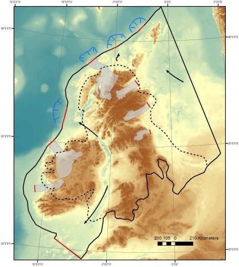
Offshore Energy SEA 4: Appendix 1 Environmental Baseline

of supporting prehistoric remains based on advantageous taphonomy, site and hydraulic
conditions during the marine transgression. These areas are:

   •   ‘Fossil’ estuaries and rivers
   •   The flanks of banks and ridges which have been proven to have peat layers, or which
       are likely to have peat layers
   •   Valleys, depressions, or basins with wetland or marsh deposits
   •   Nearshore creeks, mudflats, and peat deposits
   •   ‘Fossil’ archipelago topographies where sites would have been sheltered by low-lying
       islands as the sea level rose
   •   Niche environments in present coastal zones, wetlands, intertidal mudflats, lochs, and
       estuaries
   •   Caves and rock shelters in re-entrant bays, fossil erosional shorelines, submerged rocky
       shores protected by other islands, or in archipelagos
   •   Deposits of sediments formed within, or washed into rocky gullies and depressions
   •   Coastal sites comparable by analogy to modern Inuit migratory sites, adjacent to sea
       ice, giving access to marine mammals as a food resource.

Of importance is the level of subaerial weathering which takes place prior to sites being
covered with protective sediments, and the nature and timing of inundation (Bailey et al. 2020).

Palaeolithic sites and remains, whether they occur on land or within submerged contexts will
have particular importance if:

   •   Any hominin bone is present in relevant deposits
   •   The remains are in an undisturbed, primary context
   •   The remains belong to a period or geographic area where evidence of a hominin
       presence is particularly rare or was previously unknown
   •   Organic artefacts are present
   •   Well-preserved indicators of the contemporary environment (floral, faunal,
       sedimentological etc.) can be directly related to the remains
   •   There is evidence of lifestyle (such as interference with animal remains)
   •   One deposit containing Palaeolithic remains has a clear stratigraphic relationship with
       another
   •   Any artistic representation is present, no matter how simple
   •   Any structure, such as a hearth, shelter, floor, securing device etc, survives
   •   The site can be related to the exploitation of a resource, such as a raw material
   •   Artefacts are abundant (English Heritage 1998).

                                                                                           A1i.5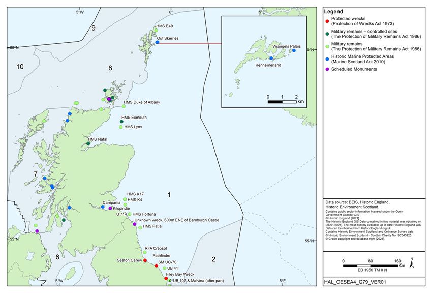
Offshore Energy SEA 4: Appendix 1 Environmental Baseline

Knowledge of the potential for offshore archaeology has previously been development led (e.g.
finds from fisheries and other industry, particular marine aggregates). The Marine Aggregate
Levy Sustainability Fund (MALSF) has assisted research in this area through its Regional
Environmental Characterisation (REC) programme. REC Studies were undertaken for areas of
the Bristol Channel, eastern English Channel, South Coast (James et al. 2010), Outer Thames
(Emu Ltd & University of Southampton 2009), East Coast (Limpenny et al. 2011) and Humber
(Tappin et al. 2011) which, amongst other topics including geology and benthos, conducted a
desk based review of marine archaeology in the study areas augmented by new survey data.
The REC programme contributed significantly to UK marine archaeology, both
methodologically and in terms of resource knowledge, for example area 240 mentioned above
(Bicket 2013). More recently, development-led work continued to be completed by offshore
developers, including for offshore wind, which in some instances leads to peer-reviewed
publications (e.g. Brown et al. 2018). A recent English Heritage (2021)3 advice note provides
some guidance to developers of offshore renewable energy developments in relation to effects
and mitigation (at a high level), the importance of written schemes of investigation to agree
methodologies, and the need to take account of the setting of historic assets, and how
perception of offshore historic environment may be affected by developments (also see
Appendix 1c).

Connected with the above is work to understand the palaeolandscapes of the UK continental
shelf that would have once been inhabited by people during glacial lowstands as described
above (see Fitch et al. 2011). This includes the work of Gaffney et al. (2007, 2009) on the
Mesolithic landscapes of the southern North Sea, subsequent research in selected areas of the
Bristol Channel and Irish Sea to the west of the UK (Fitch & Gaffney 2011) and the Channel
(Momber et al. 2011). The palaeolandscapes work highlights a number of themes including
the largely undeveloped archaeological resource of UK shelf seas, its interaction with activities
involving the seafloor, and how predictive methodologies might be developed to assess the
archaeological prospectivity of certain areas (see Section A1i.4).

The collective inventory and knowledge of maritime sites in particular is quite poor and may be
subject to recording biases, and assessments of the archaeological potential of the UKCS are
therefore speculative. The current understanding of marine prehistoric archaeology is based
on knowledge of the palaeolandscapes of the continental shelf intervening the UK and Europe
during glacial phases and limited finds of archaeological materials in this location, augmented
with knowledge of analogous cultural and archaeological contexts from modern day terrestrial
locations. A number of publications have contributed to the synthesis of progress on the
understanding of submerged archaeology and its methods (e.g. Flemming et al. 2017, Bailey
et al. 2017) of relevance to the UK including the North Sea (Cohen et al. 2017), northern North
Sea (Dawson et al. 2017), Celtic Sea and the Channel (Farr et al. 2017) and the Irish Sea and
Atlantic margin (Westley & Edwards 2017). The publications highlight the number of known
sites in European continental shelf waters (>2,600), and the potential for additional sites to be
found based on technological advances and a better understanding of the offshore
environment (e.g. Sturt et al. 2018).

Broader understanding of the historic context of the modern landscape has been delivered
through historic landscape characterisation (HLC) and historic seascape characterisation
(HSC). The methods for HSC were developed through a MASLF funded pilot in Liverpool Bay,
and a series of areas have been subject to this approach since the 2006 pilot, and the

3https://historicengland.org.uk/images-books/publications/commercial-renewable-energy-development-historic-
environment-advice-note-15/

                                                                                                       A1i.6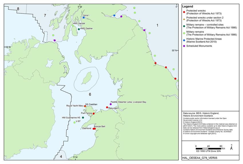
Offshore Energy SEA 4: Appendix 1 Environmental Baseline

programme is still ongoing. The outputs from these programmes are discussed in Appendix
1c.

A1i.2.2              Wrecks
The strategic importance of the sea; the concentration of much of the North Sea fishing fleet in
coastal ports; the importance of maritime trade routes in the area and the treacherous nature
of many nearshore waters, has led to a large number of ship and aircraft wrecks in UK waters,
though information on the number, type and location of these is limited.

The UK Hydrographic Office maintains a register of wreck locations; the Wrecks Database
contains ca. 70,000 records, of which approximately 20,000 are named vessels. The number
of known sites for Scottish waters stands at over 5,200, though a recent integration of data
from a number of sources has raised the number of wreck records significantly, for instance
the inclusion of 18,500 records from Ian Whittaker’s “Off Scotland” database as part of Project
Adair (Historic Scotland & RCAHMS 2013). Similarly, the MALSF England’s Shipping project
has been responsible for the creation of a GIS atlas mapping historic shipping patterns around
the UK in an attempt to improve the assessment of seabed archaeological potential4. Wessex
Archaeology (2009) put ‘best guesses’ of the wreck resource at between 100,000 and 500,000
for the wider UKCS – an indication of the number of known wreck positions is given in English
Heritage (2017). Few of these sites have had their condition or archaeological provenance
assessed, and the positional accuracy and correspondence between datasets containing
wreck data is often poor (e.g. see Grant et al. 2019). The record for wreck sites is biased
towards those from the post-Medieval and later periods, presumably a function of greater traffic
and increased reporting associated with the introduction of marine insurance (Jamieson et al.
2007) and the Lloyds of London list of shipping casualties in 1741 (Wessex Archaeology
2009). Wessex Archaeology (2004b) collated information relating to trade routes and patterns
of shipping, focussing on the Medieval period to counter this bias towards later wreck
recording, the final output being a digital atlas to complement existing information on known
wreck locations. Information regarding the whereabouts of wrecks may also be influenced by
selective reporting, for instance those wrecks recorded in the Severn Estuary are clustered
around sandbanks and shipping channels where knowledge of their whereabouts is
advantageous to seafarers (Jamieson et al. 2007). A corollary of this may be that there are
many undiscovered wreck sites in areas which do not meet these criteria.

In addition, it must be considered that there is the potential for substantial aircraft remains
(primarily WWII) to be found on the seabed both within and outside of the 12nm limit. Although
the overwhelming concentration of losses is in the period between 1939 and 1945, aircraft
losses at sea span the entire period of aviation history from the early 20th century to very
recent post-WWII losses. Sites relating to losses have become an increasing concern for both
the heritage and offshore development sectors. In response to an increasing number of finds
by the dredging industry, guidance has been published on the actions to be taken on discovery
of military aircraft at sea (Wessex Archaeology 2008a, b). The wider concern of interactions
between offshore industry (particularly renewables) and the marine archaeological resource,
has led to the development of a series of guidance documents (see Wessex Archaeology
2007, COWRIE 2008, Gribble & Leather 2011, English Heritage 2013, Historic England et al.
2018, Historic England 2021).

Aircraft remains on the seabed are also often ephemeral and not easily distinguishable in
standard geophysical surveys, for instance a B-24 Liberator bomber lying in more than 50m of

4   http://www.wessexarch.co.uk/projects/marine/alsf/englands_shipping/index.html

                                                                                           A1i.7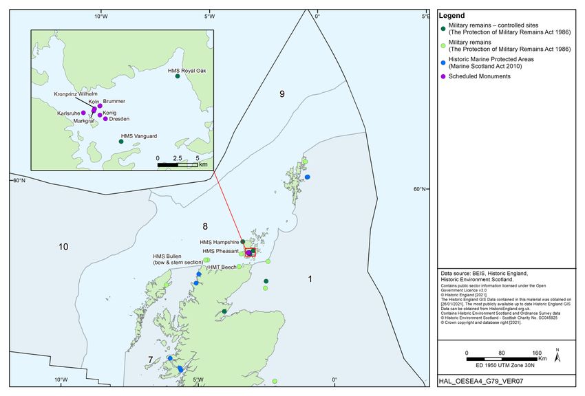
Offshore Energy SEA 4: Appendix 1 Environmental Baseline

water off the Hampshire coast identified by Wessex Archaeology in 2006 was previously
recorded by UKHO as a small, intact, possibly wooden shipwreck (Wessex Archaeology 2009).
Though there are extensive documentary sources relating to aviation loss at sea, these do not
provide accurate positions and there is no single list of losses, which may be expected to
exceed 13,000 (Wessex Archaeology 2009) – for instance see Chorley’s nine volume RAF
Bomber Command Losses of the Second World War (various dates), Franks’ three volume
Royal Air Force Fighter Command Losses of the Second World War (various dates) and
McNeill’s publication about Coastal Command losses (McNeill 2003).

Wessex Archaeology (2009) categorise aviation losses into three chronological divisions:

      •   Pre-1939 – the period during which flight technology was developed. Few flights over
          water and the fragility of airframes make any find of interest. At least 119 aircraft
          models were used by the UK military during this period, examples of only 24 survive.
      •   1939-1945 – Technological advances had increased the reliability and range of aircraft
          and large areas of the UKCS were flown over during WWII. This period also saw the
          highest number of aircraft and associated human casualties in aviation history.
      •   Post-1945 – Jet propulsion was rapidly developed. Losses in the UKCS of military
          aircraft during training sessions are of particular importance.

A1i.2.3              Coastal archaeology
Attention is brought to numerous initiatives, for instance the Archaeology Scotland has
attempted to recruit local amateurs to monitor and report on coastal archaeology which might
include local history and archaeology societies, schools and branches of the Young
Archaeologists’ Club (YAC) – the project is entitled, ‘Shorewatch’. The Scottish Coastal
Archaeology and the Problem of Erosion (SCAPE) Trust also conducted 28 coastal zone
assessment surveys between 1996 and 2009 for a number of regions in association with
Historic Environment Scotland (formerly Historic Scotland) and other organisations such as the
Centre for Field Archaeology. A standardised database of sites at risk is available through an
online map5.

Similarly, Historic England has been undertaking a series of Rapid Coastal Zone Assessment
Surveys (RCZAS) since the 1990s which have the broad aims of identifying materials of
Palaeolithic or later age in the coastal zone so that they might be added to the National Record
of Historic England (formerly the National Monuments Record) and Sites and Monuments
Record (SMR) and considered in relation to Shoreline Management Plans (SMP) – see the
review of the programme provided in English Heritage (2019). A series of reports are available
from the Historic England website6 and have previously been listed in Murphy (2014). The
Arfordir Project was also concerned with the coastal archaeology, and used volunteers to
record archaeological sites on the coast of Wales and the changes affecting them.

More generally, the National Record of Historic England, the National Record of the Historic
Environment in Scotland, and National Monuments Records of Wales and Northern Ireland,
hold more than 11.5 million records on the terrestrial and maritime archaeology of the UK, and
may be consulted via their respective websites:

5   https://scapetrust.org/sites-at-risk/
6   https://historicengland.org.uk/images-books/publications/

                                                                                             A1i.8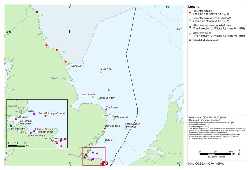
Offshore Energy SEA 4: Appendix 1 Environmental Baseline

   •   England: https://www.heritagegateway.org.uk/gateway/
   •   Scotland: https://canmore.org.uk/
   •   Wales: https://rcahmw.gov.uk/ and https://archwilio.org.uk/arch/
   •   Northern Ireland: https://www.communities-ni.gov.uk/services/sites-and-monuments-
       record, also see: https://www.communities-ni.gov.uk/publications/historic-environment-
       digital-datasets
While the above resources provide records of intertidal and nearshore finds, attribution of
these can be indiscriminate. For example, the records may not provide an indication of
whether material recorded in the intertidal area is likely to have been reposited, and whether
the redeposition may be from the marine of terrestrial environment (Bailey et al. 2020).

A1i.2.4          Site designations
Sites in territorial waters may be protected if they fall within the definitions of the Protection of
Wrecks Act 1973 or the Marine (Scotland) Act 2010. Information on the selection guidance for
historic wreck designations is provided in Historic England (2017). Additionally, some military
sites which are also of historic interest may be more widely protected in all UK waters under
the Protection of Military Remains Act 1989, either as controlled areas or designated vessels
(see Appendix 2 for more information). Intertidal and sites out to 12nm may be designated as
scheduled monuments under the Ancient Monuments and Archaeological Areas Act 1979 and
buildings may also be listed under the Planning (Listed Buildings and Conservation Areas) Act
1990 into the intertidal area, and the relevance of these features is often in relation to their
setting in addition to the specific periods or characteristics they represent. The Ancient
Monuments and Archaeological Areas Act is not typically used to designated wrecks, although
does contain provisions to schedule these.

The Historic Environment (Wales) Act 2016 made amendments to the above Acts in relation to
scheduled monuments and listed buildings in Wales, and is accompanied by a range of
updated planning and other advice notes. The Act amended the Ancient Monuments and
Archaeological Areas Act 1979 such that “Monument” also has the meaning, “any site in
Wales...comprising any thing, or group of things, that evidences previous human activity”,
which mirrors the wording of the Marine (Scotland) Act 2010 with regards to those marine
historic assets which may be considered for designation as a Historic Marine Protected Area.
Northern Ireland may also schedule monuments including in territorial waters under the
Historic Monuments and Archaeological Objects (Northern Ireland) Order 1995.

The number of statutory or other designations is small compared to the number of recorded
sites or features, both in the terrestrial and marine environment. The Marine Policy Statement
(MPS) indicates that though not subject to designation, some sites are of equivalent
importance, and a lack of designation does not necessarily indicate a lower significance. A
wider overview of the international, national and local legislation and policy relevant to this
topic is provided in Appendix 2, and relevant designated terrestrial sites are mapped in
Appendix 1j. Additionally, while the UK has not ratified the 2001 UNESCO Convention on the
Protection of the Underwater Cultural Heritage, the principles of the Convention have been
adopted by the UK.

                                                                                                A1i.9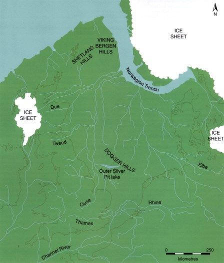
Offshore Energy SEA 4: Appendix 1 Environmental Baseline

A1i.3                 Features of Regional Sea 1
A1i.3.1               Submerged heritage
The ability to predict the occurrence of prehistoric remains, particularly in the north of Regional
Sea 1, is much lower than areas further south (e.g. Regional Sea 2), partly due to a covering of
glacio-marine deposits, the infilling of sea-bed features by modern sediments, which impairs
any ability to assess the prehistoric landscape or fluvial drainage patters (Flemming 2004b) –
however note the work of Gaffney et al. (2007, 2009) using seismic data for areas of southern
North Sea to reconstruct such features.

Offshore spot finds in Scottish waters are relatively few and are dominated by post-Medieval
items (see Lancaster 2012). The discovery of a single flint scraper in a borehole core off the
Viking Bank (150km northeast of Lerwick) is unique not just for its depth, but also for its
distance from the shore. The flint could be as old as 11,000 BP (Long et al. 1986) and
implications of such a find are discussed in Flemming (2003). If not secondarily derived, the
find suggests human occupation of the Scottish shelf in pre-Holocene times, or a stone tool
lost during a fishing expedition (Finlayson & Edwards 2003). Due to the proximity of this area
to the early Holocene coastline, there is a high likelihood that pre-9,000 BP finds are to be
made in the current offshore area which may consist of fish spears or harpoons like those
found further south in the Leman and Ower Banks (Flemming 2004b).

Submerged peatlands are known from Shetland, offshore and in the intertidal zone, which may
yield archaeological finds in situ and be useful in environmental reconstructions, though the
extent of post-glacial offshore landscapes in Scottish waters and those in the north of England
are poorly mapped to date (Ashmore 2003b, Lancaster 2012), though extensive 2D and some
3D survey coverage is available from industry-led studies which could be used to make
landscape reconstructions in Regional Sea 1 (Fitch et al. 2011). In English waters, a
submerged forest and peatland is known from Hartlepool Bay, within which a number of
Neolithic finds including that of a human skeleton, wooden stakes and worked flints are known
(Waughman 2005, Hazell 2008). More widely, Historic England maintain an Intertidal and
Coastal Peat Database, which details numerous finds within coastal areas of England, and in
the North Sea7.

Prehistoric submarine archaeological remains back to a date of about 12,000 BP could occur
with low probability anywhere in the northern region of Regional Sea 1 (Flemming 2004b), and
Sturt et al. (2013) suggest that by 11,000 BP the marine transgression would have progressed
to approximately 57.5˚N, limiting the date for occupation sites in the northern part of the region.
The likelihood of earlier Palaeolithic remains surviving on the seabed further south increases
due to a probable longer occupation episode following glacial retreat, for example a lower
Palaeolithic find was made off the coast of Scarborough (Wessex Archaeology 2004a). The
Mesolithic period is strongly represented in Scottish archaeology (e.g. see Melton 2008, Saville
& Wickham-Jones 2012, Timpany et al. 2017, and Section A1i.3.3 below) though marine finds
are few – artefacts have been located at Brown Bay near Newcastle in rock gullies. Note that
for this find, the lack of a stable surficial layer of sediment indicates that the recovery of
prehistoric items may not be restricted to sites encased in Holocene or Quaternary sediments
(Spikins 2003 cited in Flemming 2004b).

7   https://historicengland.org.uk/research/current/heritage-science/intertidal-peat-database/

                                                                                                 A1i.10
Offshore Energy SEA 4: Appendix 1 Environmental Baseline
In addition to the relatively earlier transgression in Regional Sea 1 compared to more southerly
areas, the strong current conditions in Regional Sea 1, the exposure to North Atlantic storms
and the thin sediment cover in many places also make some areas of the shelf likely poor
prospects for the survival of prehistoric deposits in situ, other than in submerged caves and
gullies. Later periods are represented offshore by maritime losses, either wrecks or overboard
losses, as the marine transgression in Regional Sea 1 would have been complete by ~8,000
BP, or perhaps even earlier (see Sturt et al. 2013).
Offshore aggregate extraction is minimal in Scottish waters despite the available resource due
to readily availability of onshore supplies. Though largely destructive to archaeological sites,
aggregate extraction and other development-led archaeological finds have proved fruitful in the
generation of knowledge about the Pleistocene offshore environment and its inhabitants (see
Section A1i.4 below). The relative paucity of such material in Scottish and north east English
waters may in part be a reflection of a lack of such development, though the offshore oil and
gas industries, and more recently marine renewables, may contribute to the collection of data
for archaeological prospecting (e.g. through acoustic surveys and coring, and adherence to
industry guidance).
A1i.3.2 Wrecks
Table A1i.2 below summarises information on designated wrecks within Regional Sea 1, and
these are also shown in Figure A1i.2.
Table A1i.2: Protected wrecks within Regional Sea 1
Wreck or Date of Site summary Position or
site name sinking Named
Location
Marine (Scotland) Act 2010: Historic Marine Protected Areas
Kennemerland 1687 A merchant ship of the Dutch East India Company lost at 250m zone
the South Mouth entrance to the harbour of Out Skerries in centred on
1664. The vessel had left Texel (Holland) for Batavia (East 60˚25.167’ N
Indies) with a variety of goods for private trade. A number 00˚45.121’ W
of other wrecks with East India Company connections are
present around Shetland, with the Kennemerland arguably
the best preserved and most fully recorded site.
Wrangels 1857 A Swedish-built Danish warship reported as lost at Lamda 100m zone
Palais Stack close to Bound Skerry in July 1687. The vessel ran centred on
aground while patrolling between Shetland and Iceland as 60˚25.467’ N
part of a wider squadron of vessels. Other wrecks with 00˚43.388’ W
Swedish or Danish connections are found around Shetland,
with Wrangels Palais representing the earliest and most
fully recorded example.
Campania 1918 The wreck is a Cunard liner launched in 1892 and later 150m zone
converted in 1914 as a Fleet Air Arm carrier. The wreck centred on
lies at a depth of 22-25m, 1.7km SSE of the entrance to 56˚02.404’ N
Burntisland Harbour, Fife. The ship represents the first of 03˚13.497’ W
the steam-driven, steel-constructed transatlantic liners not
to rely on auxiliary sails and a unique survival of a
Clydebuilt liner converted to carry aircraft. The remains of
the ship comprise a large iron feature ~120m in length
orientated NE-SW and 20m in width. Sonar confirms
substantial survival of the deck structure and fittings. In
A1i.11Offshore Energy SEA 4: Appendix 1 Environmental Baseline
Wreck or Date of Site summary Position or
site name sinking Named
Location
view of the size of the vessel and its location in a sediment-
rich seabed, there remains considerable scope for the
presence of preserved material.
Ancient Monuments and Archaeological Areas Act 1979: Scheduled Ancient Monuments
Kilspindie Hulk 19th-20th c. The site comprises the remains of eight sailing fishing 56˚ 00′ 45.039′′
(1-8) vessels, dating from the late 19th to the early 20th century. N
They lie on intertidal mudflats on the south foreshore of 02 52′ 00.015′′
Aberlady Bay, 240m east of Kilspindie. W;
56 00′ 46.619′′ N
02 52′ 05.362′′
W;
56 00′ 44.291′′ N
02 52′ 05.195′′
W;
56 00′ 46.129′′ N
02 52′ 05.987′′
W;
56 00′ 45.761′′ N
02 52′ 07.710′′
W;
56 00′ 45.365′′ N
02 52′ 08.799′′
W;
56 00′ 45.817′′ N
02 52′ 08.982′′
W;
56 00′ 46.419′′ N
02 52′ 10.786′′ W
Unknown ~18th/19th The wreck of a pre-1840 unknown wooden sailing vessel NGR NU18927
wreck, 600m c. thought to be later 18th century in origin. It is considered 35246
ENE of likely that given the nature of the timber and its
Bamburgh provenance, that the vessel was a coastal trader.
Castle
Protection of Wrecks Act 1973: Protected Wrecks
Filey Bay possibly Lying in a highly mobile sandy environment, the Filey Bay 300m zone
Wreck 1779 wreck was initially found in 1974 and was not designated centred on
until 2002. Though possibly being the remains of the 54˚ 11.502’ N
French East Indiaman, Bonhomme Richard, positive 00˚ 13.481’ W
identification is hindered by a lack of cannons or other
distinguishing features, though the wreck does conform to a
late 18th century style consistent with that of the vessel.
Seaton Carew ~19th The site contains the remains of an 18th century oak 100m zone
century English collier brig, believed to have been beached at centred on
Seaton Carew during a storm though there is generally a 54º 39.50’ N
lack of evidence relating to the site. A substantial portion 01º 10.71’ W
(~33%) of the original hull survives.
Protection of Military Remains Act 1986: Controlled Sites
HMS Natal 1915 An armoured “Warrior class” cruiser built by Vickers at 100m exclusion
Barrow and may be the last 'conventional' cruiser, powered zone centred on
by coal with an oil backup. Construction was completed in 57˚ 41.244’ N
A1i.12Offshore Energy SEA 4: Appendix 1 Environmental Baseline
Wreck or Date of Site summary Position or
site name sinking Named
Location
1907 and sank at anchor in Cromarty in December 1915, 04˚ 08.310’ W
apparently as the result of an internal explosion.
HMS Exmouth 1940 HMS Exmouth was built in 1934 and sunk on 21 January 200m exclusion
1940, being torpedoed by U-22 whilst escorting the MS zone centred on
Cyprian Prince. The wreck was relocated in 2001 and 58˚ 18.467’ N
subsequently investigated. No bell was found and no ship's 02˚ 59.001’ W
name or pendant number was identified but features
recognised included two detached and inverted mountings
('gun turrets'), torpedo tubes and boat davits in
recognisable positions.
Protection of Military Remains Act 1986: Protected Sites*
HMS 1914 Built by Cammell Laird, Birkenhead, completed in 1905 and Eyemouth
Pathfinder torpedoed by German submarine U-21 September 1914.
The wreck of HMS Pathfinder is located off Eyemouth,
Berwickshire.
HMS Lynx 1915 A K (Acasta) class vessel built in London and Glasgow to Moray Firth
an Admiralty design. Completed in 1913 and mined off the
Moray Firth in 1915.
HMS Duke of 1916 An armed boarding steamship sunk by UB-27 20 miles east Orkney
Albany of the Skerries in August 1916.
RFA Creosol 1918 Torpedoed and sunk by German submarine UC-17. Sunderland
HMS K4 1918 The wrecks of two British K-series submarines built by Isle of May, Firth
Vickers at Barrow-in-Furness. Sunk in the “Battle of May of Forth
HMS K17 Island” January 1918.
HMS Fortuna 1941 The vessel was requisitioned for use as auxiliary patrol St Abb’s Head
vessel. Bombed and sunk by German aircraft off St Abb’s
head.
HMS Patia 1941 Remains of 1941 wreck of British aircraft catapult vessel Northumbria
which foundered 6 miles east of Beadnell Point after being
bombed en route from the River Tyne for Belfast.
RFA Isleford 1942 The vessel was on passage from Lyness to Invergordon, Wick
and was employed as a naval armament vessel.
U-714 1945 The boat lies on its starboard side with damage apparent to Firth of Forth
the stern buoyancy tank. The vessel was sunk by HMS
Natal off the Firth of Forth in March 1945.
HMS E49 1917 An E-class submarine lost by mining off Shetland. Shetland
UB-41 1917 German submarine, torpedoed off Robin Hood’s Bay. Robin Hood’s
Bay
UB-75 1917 A German submarine, lost by mine off Bridlington Bridlington
UB-107 1918 German submarine; nature of loss unknown. Flamborough
Head
Notes: *=designated as a ‘protected site’ under the PMRA 1986 – no specific coordinate data is provided, only a
named location. Source: Historic Marine Protected Area Records, the CANMORE database, the National
Heritage List for England, the MCA Protected Wrecks gov.uk webpage, the Protection of Military Remains Act
1986 (Designation of Vessels and Controlled Sites) Order 2019, Colledge & Warlow (2010)
A1i.13Offshore Energy SEA 4: Appendix 1 Environmental Baseline
Figure A1i.2: Protected wrecks in Regional Sea 1
In addition to designated sites, a large quantity of wrecks is present in inshore and offshore
waters in Regional Sea 1. Many of these are recorded by the UKHO and/or listed on
monuments records which provide some information about their location, the period to which
they date and any associated archaeological finds (Table A1i.3).
Table A1i.3: Maritime archaeological records categorised as ‘wreck’ or ‘aircraft’ for Scottish
Council areas and English Counties relevant to Regional Sea 1
County/Council Number of wreck Summary of wreck sites
District sites
Craft Aircraft
Scotland
Highland 3,191 143 The highest densities of wrecks are located around Firth of
Forth and between Rattray Head and Kinnaird Head in
Moray 631 64 Aberdeenshire, reflecting the greatest level of activity and
navigational hazard respectively. Known build dates for
Aberdeenshire 2,950 54
vessels range between 1841 and 1942, however a number of
Angus 906 58 ports in the region date to earlier periods, and the lack of
earlier definitive dates does not preclude earlier wrecks and
Fife 1,949 141 may be a reflection of the inheritance of UKHO data into the
NMRS. Vessels are largely recorded as cargo steamships or
Falkirk 80 - fishing vessels, with nearly half of the latter category attributed
to naval requisitions in the first and second world wars. Most
West Lothian 6 -
A1i.14Offshore Energy SEA 4: Appendix 1 Environmental Baseline
County/Council Number of wreck Summary of wreck sites
District sites
Craft Aircraft
City of Edinburgh 368 2 recorded losses are recorded as due to accident rather than
deliberate or military losses. Identified aircraft are generally
East Lothian 933 32 from WWII, with earlier craft having smaller preservational
prospects due to the fragility of their airframes.
The Scottish 550 12
Borders
England
North Yorkshire 1,638 2 Finds extend back to the Medieval period, though represent a
small proportion of all wreck records, which are dominated by
Durham 218 2 19th and 20th century losses, and similar to areas further north,
aircraft are generally attributable to WWII losses.
Northumberland 1,372 40
Tyneside* 1,167 9
Notes: *includes North Tyneside, South Tyneside and Newcastle upon Tyne. The number of records includes
those which do not have definitive positions and records which relate to wrecks once recorded but now lost, or
else excavated. Source: Historic England Heritage Gateway database, the CANMORE database, Lancaster
(2012)
A1i.3.3 Archaeological sites in the coastal zone
In a survey of Scotland’s coastal archaeology (Dawson 2003) covering 20% of the Scottish
coast, 37% of the coastal heritage encountered was under threat from erosion, tentatively
extrapolated to a total of 12,400 potentially threatened sites for the whole of Scotland
(Ashmore 2003b). Investigations of Scotland’s coastal archaeological resource continue,
particularly where erosion threatens the loss of sites prior to their investigation (for instance the
SCAPE Trust and its related publications and projects such as SCHARP8). The number of
sites encountered per km of coast in the study area relative to Regional Sea 1 varies from 1.9
(Shetland) to 4 (Highlands). The archaeological resource of the English section of the
Regional Sea 1 coast is detailed in Fulford et al. (1997) and Murphy (2014).
Shetland contains a wealth of coastal archaeological sites dating back to prehistoric times,
including Mesolithic and Neolithic finds (Melton & Nicholson 2004, Gillmore & Melton 2011,
Montgomery et al. 2013), standing stones, burial chambers (cairns), Iron Age forts (brochs)
(Wilson 2003a) and Norse (McGovern 1990) and later sites. Artefacts dating to the Mesolithic
are few, and lithic deposits may be hidden below peat or in coastal sand and in offshore areas
submerged by rising sea levels (Edwards 1996, Flemming 2003). The existence of Mesolithic
peoples is also evidenced in the palaeoecological record for the islands (e.g. Edwards et al.
2005, 2009, Edwards 2009), with West Voe being a particularly important site (Melton &
Nicholson 2004).
Surveys of the inner Moray Firth have uncovered evidence of Mesolithic shell middens in the
Inverness area (Hale & Cressey 2003). The remains of a number of late Bronze Age and Iron
Age marine crannogs in the Beauly Firth (e.g. Redcastle) represent almost 50% of the total
number of known crannogs in intertidal waters (Hale 2000, cited in Hale & Cressey 2003).
Fish traps built during the 17th-19th century to catch salmon are relatively common in the
8 Scotland’s Coastal Heritage at Risk Project (SCHARP), see Dawson (2013, 2014).
A1i.15Offshore Energy SEA 4: Appendix 1 Environmental Baseline
intertidal zone and are concentrated in the Beauly Firth and Cromarty Firth. Early 20 th century
monuments include WWI and WWII military complexes on the North and South Sutors, the
remains of an airfield at Evanton and the RAF seaplane base at Alness Point (and related
aircraft losses in the Moray Firth). The heavy military presence attests to the importance of the
Cromarty Firth, especially as a naval base during both World Wars (Hale & Cressey 2003).
A survey of the Fife coast (Robertson 1996, Robertson & Miller 1997) found evidence of
fossilised trees on the shore near Crail as well as prehistoric land exposures on the muddy
foreshore of the Tay Estuary which may date to around 5,500 BP. A series of temporary
camps discovered at Fife Ness and Tentsmuir provide evidence of Mesolithic settlement.
Prehistoric shell and pottery middens as well as fishtraps may also be present. Evidence of
Roman activity is limited to scattered finds (e.g. Boat Haven pottery and finds from
Constantine’s Cave). Pictish burial sites (e.g. Old Haiks Long Cist; Lundin Links) and carvings
within cave systems (Constantine’s Cave; Randerston Castle Cave; Kinkell Cave) are found in
raised beach deposits to the south-east of St Andrews. Salmon fishing on the Tay has
probably taken place since at least Roman times and evidence of structures associated with
the industry are commonplace, particularly on the south shore of the Tay. The majority of 20th
century coastal sites in Fife, and further north along the Angus coast, are military defences
from WWI or II (Robertson 2003, Dawson et al. 2009). A survey of the Angus coastline
emphasises the number of potentially unrecorded sites, with 52% of sites surveyed not
previously recorded, 81% of which were located in the intertidal area (Dawson et al. 2009).
The majority of coastal sites found during a survey of the Firth of Forth (James 2003) were
attributed to the post-medieval period and included industrial, commercial and domestic
buildings, harbours, docks, piers, wartime defences, designed landscapes, wooden structures,
wrecks, sea-wall defences, and outdoor swimming pools. Prehistoric sites found included a
Mesolithic shell midden (Kinneil Kerse) and an antler implement; Neolithic pottery and a stone
axe; Bronze Age burial chambers and Iron Age forts, caves, burial sites, middens and
jewellery. A number of Roman forts and other structures, as well as a brooch and a Roman
coin, have been described, as have Early Christian burial sites, chapels and monastic
settlements. A number of medieval castles, religious sites, battle sites, harbours and
settlements have also been recorded (James 1996, James 2003).
Lower Palaeolithic finds along the coast of Regional Sea 1 may be limited by glacial readvance
(Wymer 1999), though isolated hand axes have been found at Redcar and Blackhall (Tolan-
Smith 2008, cited in Murphy 2014). The area of English coast from the Tweed to Flamborough
Head has numerous associated reports of submerged forest (e.g. at Cresswell, Hauxley,
Seaburn, Hartlepool Bay, Hornsea, Owthorpe and Easington (Bradley et al. 1997) indicative of
former landscapes which may have been previously occupied. Mesolithic activity is
documented along the entire English north-east coast (Burn 2010), with finds recorded in
surveys on the Durham and North Yorkshire coasts (Wessex Archaeology 2004a), though the
Late Upper Palaeolithic and Mesolithic are poorly represented in North Yorkshire (Brigham
2014). Notable sites include those at Howick (Boomer et al. 2007, Waddington 2007) and Low
Hauxley (Waddington 2010) displaying both evidence of occupation, including fossil human
and animal footpints, and interaction with the Storegga event. Mesolithic scatters have also
been found at Budle Bay, Crimdon Dene, Cresswell and Filpoke Beacon (Murphy 2014).
A prehistoric wattle screen has been exposed at Seaton Carew, south of Hartlepool which was
embedded in peat and drowned forest (Buglass 1994 cited in Flemming 2002), as has a
probable Neolithic or early Bronze Age fish trap (Annis 1994). Artefacts have been recovered
from this beach for many years, with skeletal remains being discovered in 1971 from peat.
Peat from this area yielded a date of 5,000-4,200 BP (Flemming 2002).
A1i.16Offshore Energy SEA 4: Appendix 1 Environmental Baseline
A significant array of dunes form the English coast from the Scottish border south to
Hartlepool: these may have the potential to preserve prehistoric landscapes in buried soils,
evidenced by other finds in analogous coasts in England (e.g. Newquay), and the later buried
medieval site at Lindisfarne exemplifies this process (Bell 1997). Early Bronze Age material is
present along the north Northumberland coast, contained in sand dunes which are exposing
this material as they erode, and later, Neolithic finds are being eroded at Flamborough Head in
the form of discoidal knives and transverse arrowheads (Bradley et al. 1997, also see Brigham
et al. 2008). Bronze Age round barrows, cairns and other ritual structures are located on the
northeast coast, including a cist cremation cemetery and associated cairns at Low Hauxley
which is contained below eroding dunes (see Waddington 2010).
The pre-Roman and Roman Iron Age are virtually indistinguishable on the north-east English
coast and no records of Roman Iron Age within the intertidal zone north of the Tyne have been
recovered, despite that the Tyne would have been an important access route for troops and
supplies, and the distribution of other finds point to the likelihood of port activities (Bradley et
al. 1997). Iron Age multivallate forts are a feature of the coast between the Scottish Borders
and Low Newton-by-the-Sea, with examples at Howick Hill, Fenham and Scremerston, and a
range of other Iron Age features (crop marks, settlement enclosures) in Northumberland have
been recorded on aerial photography (Murphy 2014). Further south, settlement sites tend to
be inland from the coast, however finds in cliff sections at Cloughton and Reighton imply more
extensive settlement landscape yet to be discovered (Brigham 2014, Murphy 2014).
Herd Sand at South Shields provides the source of at least 25 coins from the 1 st and 2nd
centuries. Several Roman signal stations which have either been severely eroded or are
subject to current and probable future erosion, occur at Huntcliffe, Goldsborough, Ravenscar,
Scarborough and Filey (Bradley et al. 1997). Finds south of the Tees also indicate the
potential for Roman remains to be found in this location.
There is little archaeological evidence for the early Medieval period in the north east of
England (Brigham 2014), however later Medieval sites have the greatest number for the north
east coast, with 110 known locations for the Durham and North Yorkshire areas – the entire
post-Roman period yields 145 individual records for the same area (Wessex Archaeology
2004a). Extensive Medieval and post-Medieval ridge-and-furrow has been identified in aerial
surveys of the north-east most of which has been levelled or otherwise obscured by modern
farming and building (Brigham 2014, Murphy 2014). In the post-Medieval period, the coast of
the north east of England began to be characterised by agricultural enclosure and the spread
of rural industries, and also alum and stone quarrying which led to permanent landscape
change, though the area remains largely rural in nature (Brigham 2014).
A1i.4 Features of Regional Sea 2
A1i.4.1 Submerged heritage
Research by Gaffney et al. (2007, 2009) has highlighted how the reconstruction of the
palaeolandscapes of the southern North Sea using 3D seismic data might be used to reveal
the potential archaeological resource and develop a predictive methodology. For instance, the
mapping operation revealed the Outer Silver Pit would have dominated the palaeolandscapes
of the southern North Sea, featuring a significant drainage basin with resources including a
lake or marine outlet with an extensive coastline, numerous estuaries and salt marsh (Fitch et
al. 2007). The availability of resources suitable for human habitation in this area makes it a
prime location for late Mesolithic archaeology and the study of possible maritime resource use.
A1i.17Offshore Energy SEA 4: Appendix 1 Environmental Baseline
While the Silver Pit itself is not regarded to be particularly prospective, Gaffney et al. (2007,
2009) indicate that, with caution, former lacustrine environments, marshland and coasts
identified using the methods deployed in the North Sea Palaeolandscapes Project9 could be
used to support more detailed investigations (see Missiaen et al. 2021, and below). An
overview of the topography of the palaeolandscape identified by Gaffney et al. (2007) is
provided in Figure A1i.3.
Similar work has been undertaken as part of the Humber (Tappin et al. 2011), East Coast
(Limpenny et al. 2011) and Outer Thames (Emu Ltd & University of Southampton. 2009)
Regional Environmental Characterisations, which interpreted offshore channel systems and
plot wrecks and other archaeological findspots within the relevant study areas.
To date no maritime archaeological artefacts of lower Palaeolithic origin (ca. 900-300kya) have
been recovered from the southern North Sea (Hosfield 2007). Lower and Middle Palaeolithic
material is likely to be present within fluvial terrace deposits off East Anglia and in the Thames
Estuary (Wenban-Smith 2002), with evidence from coastal sites including at Happisburgh and
Pakefield that maritime sites of such an age could survive offshore. The current method of
recovery and collection of much marine archaeology (e.g. dredging or trawler by-catch) is
coarse and produces an archaeological mix of poor spatio-temporal resolution (Glimmerveen
et al. 2004, Hosfield 2007).
Limpenny et al. (2011) note that there have been 30 reported prehistoric finds made through
the BMAPA protocol from aggregate areas of East Anglia which include worked flint and faunal
remains. This includes a collection of 28 Palaeolithic hand axes from dredged material 11km
off the coast of Great Yarmouth in licensed dredging area 240, which were accompanied by a
series of bones including woolly mammoth, bison and reindeer. The finds were recovered from
sediments which were probably associated with a buried channel feature, and are currently
regarded as perhaps the most significant Ice-age artefacts from the North Sea to date, being
dated to MIS 8/7 (250-200kya) (Tizzard et al. 2014).
Limpenny et al. (2011) also highlight earlier work on identifying the late Pleistocene and early
Holocene landscapes off East Anglia, including the work of Fitch et al. (2005) who described a
vast plain with a complex meandering river system which developed into an estuarine and
intertidal environment in advance of the marine transgression in this area. Limpenny et al.
(2011) further identified an early Mesolithic channel associated with the Yare, infilled with a
transgressive sequence of marshland peats overlain with progressively more estuarine
sediments associated with the start of the last marine transgression at approximately 5,970
BC. Palynological evidence indicates the channel would have flowed through marshland and
open shrub woodland with birch, aspen and willow, with oak, elm and hazel dominating in outer
saltmarsh areas.
Tappin et al. (2011) similarly notes that a combination of paleoenvironmental and dating
evidence suggests that in situ Mesolithic deposits survive in the Humber REC area and can be
identified in geophysical data, mainly in the form of palaeochannels of late glacial/early
Holocene (or perhaps earlier) age, subsequently infilled with sediments. Tappin et al. (2011)
also augment the characterisation of the North Sea Mesolithic landscape undertaken by
Gaffney et al. (2007) largely confirming earlier interpretation where there was an overlap, but
also providing more definition in the character of the nearshore area. In the area not already
covered by Gaffney et al. (2007), 47 Holocene landscape areas and 120 areas with
9 http://archaeologydataservice.ac.uk/archives/view/nspp_eh_2011/
A1i.18You can also read