Strategic Fire Plan 2020 - Tuolumne-Calaveras Unit - Office of ...
←
→
Page content transcription
If your browser does not render page correctly, please read the page content below
Tuolumne-Calaveras Unit

         2020
Strategic Fire Plan
             Nick Casci, Unit Chief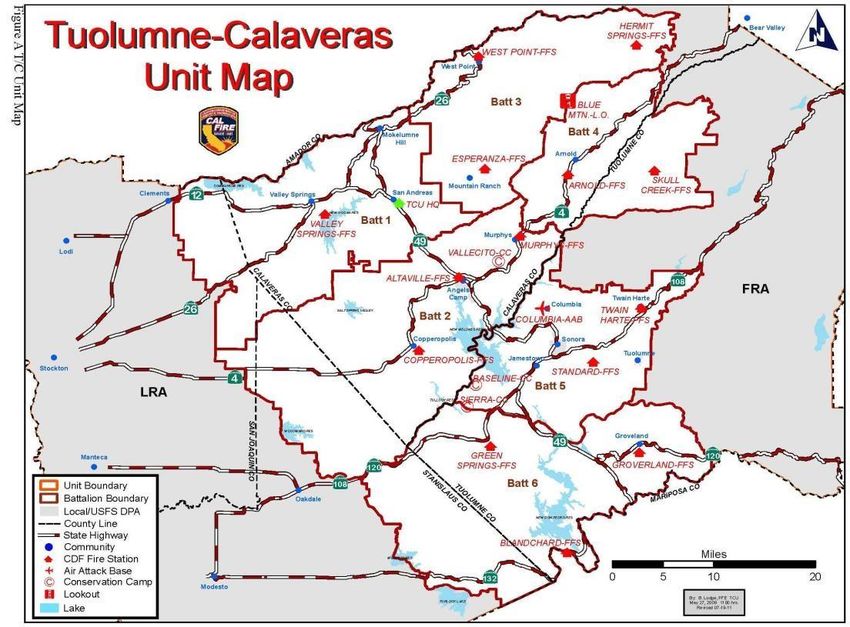
TUOLUMNE-CALAVERAS UNIT FIRE PLAN 2020
Contents
Strategic Fire Plan ............................................................................................................................1
SIGNATURE PAGE ......................................................................................................................5
EXECUTIVE SUMMARY...............................................................................................................5
SECTION I: UNIT OVERVIEW......................................................................................................6
Socioeconomic ..........................................................................................................................7
Fire Environment .......................................................................................................................8
Fire Protection Responsibilities .................................................................................................8
Unit Preparedness and Firefighting Capabilities ........................................................................9
SECTION II: COLLABORATION .................................................................................................12
COMMUNITY/AGENCIES/FIRE SAFE COUNCILS ................................................................12
SECTION III: VALUES ................................................................................................................12
VALUES: .................................................................................................................................12
LIFE SAFETY: .........................................................................................................................13
WATERSHED:.........................................................................................................................13
STRUCTURES: .......................................................................................................................15
INFRASTRUCTURE:...............................................................................................................15
AIR QUALITY: .........................................................................................................................16
AGRICULTURE: ......................................................................................................................16
CULTURAL/HISTORICAL: ......................................................................................................17
COMMUNITIES: ......................................................................................................................17
SECTION IV: PRE-FIRE MANAGEMENT STRATEGIES ...........................................................19
FIRE PREVENTION ................................................................................................................19
INFORMATION AND EDUCATION .........................................................................................21
CAL Mapper Program..............................................................................................................21
Fire Prevention Specialist Program .........................................................................................21
Prevention and Education Programs: ......................................................................................22
4291 Inspection Program/Community Partnerships:................................................................22
Fairs & Community Outreach: .................................................................................................24
VEGETATION MANAGEMENT ..................................................................................................25
Resource Management: Adam Frese – Division Chief/Unit Forester.......................................25
Hazard Fuel Reduction/Risk Mitigation....................................................................................25
SECTION V: UNIT PRE- FIRE MANAGEMENT TACTICS .........................................................26
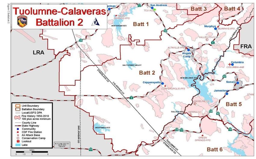
Battalion 1 - San Andreas Battalion: Kevin Bohall - Battalion Chief ............................................26
Battalion 1 - Overview .................................................................................................................26
Battalion 1 Assessment Summaries:...........................................................................................27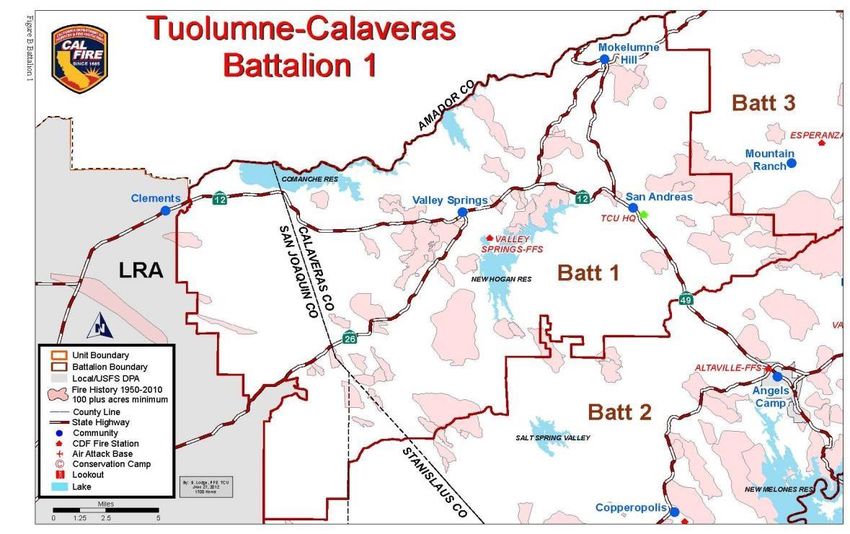
TUOLUMNE-CALAVERAS UNIT                              FIRE PLAN 2020
     Assets at Risk, Fuels, Weather and Fire History .....................................................................27
  Battalion 1 Mitigation Efforts........................................................................................................30
     Defensible Space Inspections: ................................................................................................30
     •    PRC 4291 Inspections .......................................................................................................31
     Fuel Reduction/Breaks: ...........................................................................................................31
     Battalion 1 Public Education: ...................................................................................................32
     Law Enforcement:....................................................................................................................33
  Battalion 1 Cooperators Mitigation Efforts ...................................................................................33
     Calaveras Foothills Fire Safe Council:.....................................................................................33
     Calaveras County: ...................................................................................................................34
Battalion 2 - Angels Camp Battalion: Mario Hernandez – Battalion Chief.......................................35
  Battalion 2 Overview ...................................................................................................................35
  Battalion 2 Assessment Summaries:...........................................................................................36
     Assets at Risk, Fuels, Weather and Fire History .....................................................................36
  Battalion 2 Mitigation Efforts........................................................................................................39
  Battalion 2 Public Education........................................................................................................41
     Law Enforcement:....................................................................................................................42
  Battalion 2 Cooperators Mitigation Efforts ...................................................................................42
     Calaveras Foothills Fire Safe Council:.....................................................................................42
     Calaveras County: ...................................................................................................................42
     City of Angels Camp: ...............................................................................................................43
     Stanislaus County/Modesto Fire Department: .........................................................................43
  Battalion 3 - West Point Battalion: Britan Imlach – Battalion Chief ..............................................43
     Battalion 3 - Overview..............................................................................................................43
  Battalion 3 Assessment Summaries:...........................................................................................45
     Assets at Risk, Fuels, Weather and Fire History .....................................................................45
     Battalion 3 Mitigation Efforts ....................................................................................................49
     Defensible Space Inspections: ................................................................................................50
     Battalion 3 Public Education: ...................................................................................................50
     Battalion 3 Law Enforcement:..................................................................................................51
     Battalion 3 Cooperators Mitigation Efforts ...............................................................................51
     Calaveras County ....................................................................................................................54
Battalion 4 - Arnold Battalion: Brenton Brown – Battalion Chief......................................................54
     Battalion 4 Overview................................................................................................................54
  Battalion 4 Assessment Summaries:...........................................................................................55
     Assets at Risk, Fuels, Weather and Fire History .....................................................................55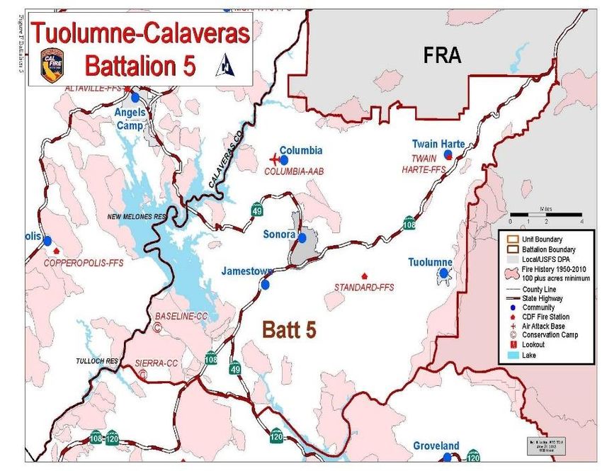
TUOLUMNE-CALAVERAS UNIT                                 FIRE PLAN 2020
  Battalion 4 Mitigation Efforts........................................................................................................58
  Battalion 4 Public Education........................................................................................................60
     Battalion 4 Law Enforcement:..................................................................................................60
     •     Cause Determination and Code Enforcement ...................................................................60
  Battalion 4 Cooperators Mitigation Efforts ...................................................................................60
     Stanislaus National Forest, USFS: ..........................................................................................60
Battalion 5 - Twain Harte Battalion: Loren Monsen – Battalion Chief .............................................64
     Battalion 5 - Overview..............................................................................................................64
  Battalion 5 Assessment Summaries:...........................................................................................65
     Assets at Risk, Fuels, Weather and Fire History .....................................................................65
  Battalion 5 Mitigation Efforts........................................................................................................70
  Battalion 5 Law Enforcement ......................................................................................................77
  Battalion 6 – Groveland Battalion: ...............................................................................................77
  Battalion 6 Assessment Summaries:...........................................................................................79
     Assets At Risk, Fuels, Weather and Fire History .....................................................................79
  Battalion 6 Mitigation Efforts........................................................................................................82
  Battalion 6 Public Education:.......................................................................................................85
  Battalion 6 Cooperators Mitigation Efforts ...................................................................................86
Battalion 9 - Emergency Command Center: Cris Adams – Battalion Chief.....................................88
     Battalion 9 Overview................................................................................................................88
APPENDIX A: PRE- FIRE PROJECTS...........................................................................................89
APPENDIX B: UNIT GOALS AND OBJECTIVES...........................................................................91
     Goals: ......................................................................................................................................91
     Objectives:...............................................................................................................................91
  Goal 1..........................................................................................................................................91
     Objectives:...............................................................................................................................92
     Measurement Criteria: .............................................................................................................92
  Goal 2..........................................................................................................................................92
     Objectives:...............................................................................................................................92
     Measurement Criteria: .............................................................................................................93
  Goal 3..........................................................................................................................................93
     Objectives:...............................................................................................................................93
     Measurement Criteria: .............................................................................................................93
  Goal 4..........................................................................................................................................94
     Objectives:...............................................................................................................................94
  Goal 5..........................................................................................................................................95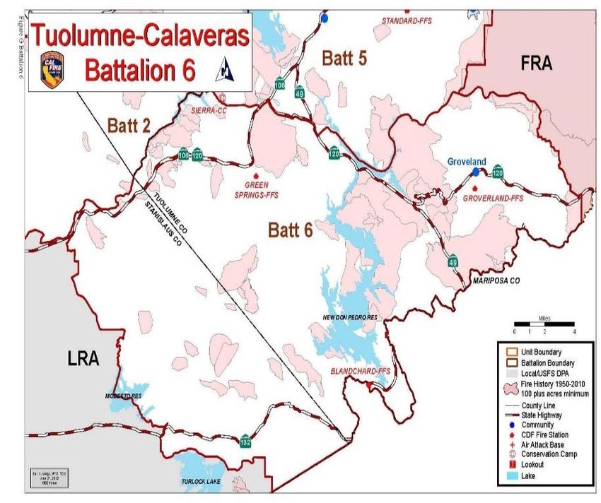
TUOLUMNE-CALAVERAS UNIT                                 FIRE PLAN 2020
     Objectives:...............................................................................................................................95
  Measurement Criteria:.................................................................................................................95
  Goal 6..........................................................................................................................................96
     Objectives:...............................................................................................................................96
  Goal 7..........................................................................................................................................97
     Objectives:...............................................................................................................................97
     Measurement Criteria: .............................................................................................................97
  APPENDICES C: Ignitions Tables/Charts ...................................................................................98
  SUPPLEMENT: 2019 ..................................................................................................................98
  Annual Report of Unit Accomplishments .....................................................................................98

SIGNATURE PAGE

Unit Strategic Fire Plan developed for the Tuolumne-Calaveras Unit.

         This plan:
            • Was collaboratively developed. Interested parties, Federal, State, City and
                County agencies within the Unit have been consulted and are listed in this
                plan.
            • Identifies and prioritizes pre-fire and post fire management strategies and
                tactics meant to reduce the loss of values at risk within the Unit.
            • Is intended for use as a planning and assessment tool only. It is the
                responsibility of those implementing the projects to ensure that all
                environmental compliance and permitting processes are met as a necessary.

               ____________________                                                  5/01/2020
                                                                                 ________________
                   Unit Chief                                                          Date
                   Nick Casci

               ____________________                                                 05/01/2020
                                                                                 ________________
                   Pre-Fire Engineer                                                   Date
                   Laura Blake

EXECUTIVE SUMMARY
Through a collaboration of our internal and external stakeholders, the CAL FIRE Tuolumne–
Calaveras Unit (TCU) initially developed and continues to update the Unit’s Strategic Fire
Plan. This methodology allows for a fire plan that will be successful in reducing the loss of
life, property and natural resources from wildland fire.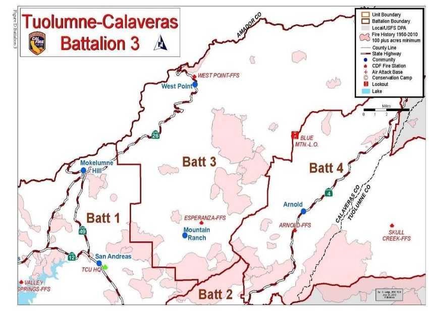
TUOLUMNE-CALAVERAS UNIT               FIRE PLAN 2020
The plan is designed to provide a comprehensive framework of how the Tuolumne-
Calaveras Unit will assess our current and anticipated hazards/risks, develop objectives to
mitigate those hazards/risks, establish benchmarks for success, develop strategies to meet
our objectives, implement those strategies, and facilitate a monitoring system to insure the
plan remains connected to the needs of the Unit and stakeholders.

The Tuolumne-Calaveras Unit is committed to the following goals:
   • Continually assess values at risk; including life, property and our natural resources.
   • Actively partner in the promotion and support of fire wise land use planning.
   • Seek opportunities for contribution and collaboration with local, county and regional
      leaders in developing of fire protection plans.
   • Maintain an active Public Information team committed to the promotion of current and
      future projects/actions which reduce or have reduced our identified hazards and
      risks.
   • Continue integration with all stakeholders to develop a seamless implementation of
      our plan across the Unit.
   • Continually evaluate and mitigate strategy for all our resources (personnel, equipment
      and facilities) to provide for the best possible level of service related to the hazards and
      risks identified. Adopt site-specific plans to address post-fire recovery.

Through the implementation of the Tuolumne–Calaveras Unit’s Strategic Fire Plan, CAL
FIRE will be a partner in reducing the cost of fire suppression, property loss, and damage to
our ecosystem. Most importantly, the plan will provide for a safer community, thereby
reducing injuries and the loss of life to both the public and firefighters.

SECTION I: UNIT OVERVIEW
The Tuolumne-Calaveras Unit is in Central California, an hour east of Modesto and
Stockton, in the foothills of the Sierra Nevada Range; a region known as the Mother Lode.
It includes much of Calaveras and Tuolumne counties, and the eastern portions of San
Joaquin and Stanislaus Counties. “The Unit” technically extends down slope from the Forest
Service boundary and into the Central Valley as far west as the San Joaquin River near
Interstate 5. However, the Unit’s Primary Operational Area (POA) begins at the LRA/SRA
boundary a few miles west of the western Calaveras and Tuolumne County lines (running
south roughly from Clements, past Woodward Reservoir to Turlock Lake) East to the Forest
Service boundary, (throughout this document the phrase “the Unit” refers to that POA). The
Unit spans an elevation range from a low of 300’ among the rolling plains of eastern San
Joaquin and Stanislaus counties to highs of near 5,000’ in central Tuolumne County, and
6,000’ feet in central Calaveras County. The heart of the Unit is cut by a series of generally
east-west oriented river canyons creating vast areas of extremely steep and rugged terrain.
In the west, the topography is generally described as rolling hills.

The entire Unit encompasses almost 2.9 million acres. There are over a million acres of
State Responsibility Area (SRA) lands within the Unit. SRA is defined as forest, brush or
grass covered lands where the State is responsible for wildland fire protection. SRA is
mainly composed of private land holdings. Lands owned and/or administered by the Federal
government are designated as Federal Responsibility Areas (FRA). Lands not designated
as SRA or FRA, typically fall within an incorporated city, are in agricultural use, or are rural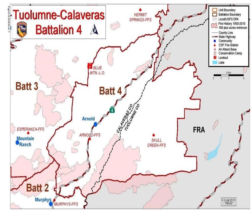
TUOLUMNE-CALAVERAS UNIT              FIRE PLAN 2020
central valley areas that don’t otherwise meet the criteria for SRA/FRA designation. These
remaining lands are designated as Local Responsibility Areas (LRA).

There are four major watersheds in the Unit: the Mokelumne, Calaveras, Stanislaus and
Tuolumne River systems. These four systems support seven major reservoirs within the
Unit: Camanche Reservoir, Hogan Lake, Pardee Reservoir, Tiger Creek Reservoir, New
Melones Reservoir, Tulloch Lake, and Don Pedro Reservoir. These hydrologic resources in
turn support major local and regional communities and industries.

Five highways run east-west in the Unit: 12, 26 and 4 in Calaveras County;108 and 120 in
Tuolumne County, State Highway 49 bisects the Unit from north to south. Many towns and the
greatest population densities in the Unit exist on or near these major transportation corridors.

Socioeconomic

The approximate population within the Unit’s two primary counties is 98,389. As of 2015, the US
Census Bureau reported an estimated population of 44,828 in Calaveras County, and 53,709 in
Tuolumne County. The population within the San Joaquin and Stanislaus County portions of the
Unit’s Direct Protection Area is far less dense and only provides a minor contribution to the total
Unit population. The major industries/employers that support the local economy include health
care, government, tourism and recreation, construction, and agriculture. In years past the timber
industry has been a significant employer. Sierra Pacific Industries operates sawmills at Standard
and Chinese Camp in Tuolumne County. American Wood Fibers operates a facility on J59 west of
TUOLUMNE-CALAVERAS UNIT               FIRE PLAN 2020
Jamestown. These facilities provide an important outlet for forest products in Tuolumne and
Calaveras Counties.

Fire Environment
Being in the heart of the central Sierra Nevada range, TCU features examples of a wide
range of challenging topography, fuels and weather. These naturally occurring elements
have a great deal of influence on the nature of wildland fires within its boundaries. An
expanding population increases the potential for large and damaging fires.

The grasslands of the rolling western plains routinely experience extreme summer heat, and
significant wind events during the spring and fall months. In these areas, motorized fire
suppression equipment can be fully utilized to great success. The brush fields, common
throughout the central portions of the Unit, lay over broad expanses of steep hillsides and
atop narrow ridgelines between the deepening river canyons. Routine summer temperatures
can be extreme, while the topography makes access difficult for motorized equipment. The
brush transitions into the mixed oak and conifer zones as the elevation increases and the
canyon depth and width increase significantly. Over 38% of the CAL FIRE DPA land is
covered with these high hazard brush and timber fuels. This mid-elevation area also
experiences high summer temperatures, and is most affected by the normal diurnal winds
associated with the canyon-dominated topography. The higher elevation zone features
dense stands of conifer timber, much of which exhibits large accumulations of ground and
ladder fuels. Temperatures are routinely moderated due to the elevation; however, wind
events in the fall can contribute to potentially challenging fire conditions.

The convergence of significant fire weather conditions, a wide variety of topography and a
broad spectrum of fuels has resulted in a long history of large damaging fires within the Unit.
Evidence of this is depicted in the Battalion maps found in the Exhibits section toward the
end of this document.

Fire Protection Responsibilities
CAL FIRE is mandated by statute to provide wildland fire protection on State Responsibility
Area lands (SRA). The federal government (USFS, BLM etc.) is responsible for wildland fire
protection on Federal Responsibility Area lands (FRA). Local government entities (city,
county, districts) are responsible for wildland fire protection on Local Responsibility Area
lands (LRA). To reduce fire protection costs, and increase the efficiency of initial attack
operations, CAL FIRE and the federal land management agencies have entered
agreements that define Direct Protection Areas (DPA) for each agency. An agency’s DPA is
the geographic area for which the agency is directly responsible for providing wildland fire
protection, regardless of SRA/FRA designation. As an example, a plot of private land (SRA
by law), well within the national forest boundary (FRA by ownership), may receive Direct
Protection by the USFS due to the closer proximity of USFS fire resources. Therefore, this
plot of SRA is designated part of the federal DPA.

Similarly, USFS land (FRA) isolated within private land (SRA) may be provided Direct
Protection by CAL FIRE due to its proximity to CAL FIRE resources. This FRA land is
included in the state DPA. On a statewide basis, CAL FIRE and the federal agencies
attempt to balance the acreage totals of these tradeoffs so that no single agency is
protecting more of the other agencies land than the reciprocating agency. Where agency
jurisdictions abut is where most DPA swaps have been agreed to. This process is guided by

TUOLUMNE-CALAVERAS UNIT                FIRE PLAN 2020
the California Master                        TUOLUMNE-CALAVERAS UNIT CAL FIRE
Cooperative Wildland Fire                      DIRECT PROTECTION ACRES 2018
Management Agreement
(CFMA) (aka “Balancing of                         Calaveras County SRA                       526,738
Acres”) in effect among                           Tuolumne County SRA                        359,785
multiple agencies. Through
                                                  Stanislaus County SRA                      174,913
this agreement, the CAL
FIRE Tuolumne-Calaveras                         San Joaquin County SRA                        60,039
Unit and the Stanislaus                           Calaveras County FRA                        95,386
National Forest provide
direct wildland fire                              Tuolumne County FRA                         86,106
protection on portions of                         Stanislaus County FRA                            17
each other’s                                     San Joaquin County FRA                            0
Responsibility Areas, as                    TOTAL CAL FIRE DPA ACRES                    1,302,984
shown in the table below.
The Bureau of Land Management, Bureau of Reclamation, Army Corps of Engineers and
Bureau of Indian Affairs are other Federal agencies with land holdings within the Tuolumne-
Calaveras Unit on which CAL FIRE provides Direct Protection. These agencies and the US
Forest Service are combined and shown as FRA in the following table.
Unit Preparedness and Firefighting Capabilities

CAL FIRE Organization

TCU manages a large Schedule B organization throughout the Unit, and a Schedule A
organization in Tuolumne County. The Schedule B program consists of the personnel,
facilities and equipment directly funded by state dollars for providing wildland fire protection
on SRA lands.

TCU is administered by the Unit Chief and a Deputy Chief of Operations, headquartered in
San Andreas, Calaveras County. Calaveras County also includes eastern San Joaquin
County, and a small portion of northeastern Stanislaus County, and a swath of private
timber land north of the Middle Fork Stanislaus River in northeastern Tuolumne County.
Tuolumne County also encompasses the southeastern portion of Stanislaus County.

The resources in Calaveras County are administered by the Deputy Chief of Operations and
includes; Vallecito Conservation Camp Battalions. Battalion 1 covers from Mokelumne Hill to
Wallace on the north, and from Jenny Lind to San Andreas on the south, and includes the
Valley Springs and San Andreas CAL FIRE Station’s. Battalion 2 covers the lower Highway
4 corridor from Eastern Stanislaus County to Murphys, and includes the Copperopolis,
Altaville and Murphys CAL FIRE Stations. Battalion 3 is the upper Highway 26 area
including the communities of Glencoe, West Point, Wilseyville, Railroad Flat and Mountain
Ranch, and includes the West Point, Esperanza and Hermit Springs CAL FIRE Stations.
Battalion 4 covers the upper Highway 4 area from Forest Meadows to Black Springs Road
and the area in Tuolumne County north of the Middle Fork Stanislaus River, and includes
the Arnold and Skull Creek CAL FIRE Stations and Blue Mountain Lookout.
TUOLUMNE-CALAVERAS UNIT              FIRE PLAN 2020
The resources in Tuolumne
County are also administered                       TCU CAL FIRE Resources
by the Deputy Chief of
                                                       Battalions                            6
Operations and includes
Baseline Conservation Camp                        State Fire Stations                       15
and two Battalions. Battalion 5           Calaveras County State Fire Stations              10
covers the Tuolumne County                Tuolumne County State Fire Stations                5
area north of the Tuolumne river           Inmate Conservation Camp Camps                    2
and includes the Standard CAL
                                                    Air Attack Base                          1
FIRE Station and the Twain
Harte CAL FIRE Station and                   Emergency Command Center                        1
two “Schedule A” stations;                              Lookouts                             2
Station 51 in Mono Village and
Station 76 in Jamestown.                   TCU CAL FIRE Operational Resources
Battalion 6 covers the area
south of the Tuolumne River                   State Fire Engines - Schedule B                21
including the Groveland,                 Local Government Fire Stations - Schedule A
Blanchard and Green Springs               (Under agreement, staffed with CAL FIRE             3
CAL FIRE Stations, and                                      personnel)
“Schedule A” Station 78,                                  Bulldozers                          2
located in Groveland.                                  Air Attack Plane                       1
                                                      Air Tanker Planes                       2
Columbia Air Attack base (fixed
wing and helicopter), Baseline                            Helicopter                          1
Conservation Camp and the                        Helicopter Support Tender                    1
Sierra Forestry Training                             Inmate Type I Crews                      10
Program are administered by a                       Inmate Type II Crews                      5
Division Chief.
                                         Fire Prevention Law Enforcement Officers             3
Local Government Fire
Organization
CAL FIRE cooperates closely with all the local city and district fire departments within the TCU
boundaries. These agencies have primary responsibility for all emergency incidents within their
boundaries, except wildland fires (exception: as LRA’s, Sonora City, Tuolumne City, San
Andreas and Angels Camp City retain wildland fire jurisdiction). CAL FIRE and local agencies
apply the concept of “closest available resource”, via long standing auto aid agreements, to
assure the appropriate numbers and types of emergency resources are utilized for every
emergency. Thus, CAL FIRE engines are responding to all incidents throughout the two
counties during the months these engines are staffed. Similarly, CAL FIRE relies heavily on
district and city resources to supplement our wildland fire response. To facilitate this level of
cooperation, TCU’s Emergency Command Center (ECC) provides contracted dispatching
services for all the local city and district fire departments in Tuolumne and Calaveras Counties,
and the Bear Valley Fire Department in western Alpine County.

   •   Calaveras County: There are 9 fire districts and 1 city department in Calaveras
       County. West Point, Mokelumne Hill, Calaveras Consolidated, San Andreas, Central
       Calaveras, Copperopolis, Altaville-Melones, Murphys, and Ebbetts Pass Fire
       Districts; and Angels Camp City Fire Department. The district boundaries combine to
       cover the entire county.
TUOLUMNE-CALAVERAS UNIT FIRE PLAN 2020
• Tuolumne County: There are seven fire districts and one city department in
Tuolumne County: Columbia; Jamestown; Tuolumne; Mi Wuk-Sugarpine; Rancheria
Fire Department; Strawberry Fire Districts; and Sonora City Fire Department and
Twain Harte Community Service District and Groveland Community Service District.
The district boundaries encompass relatively small areas surrounding the
communities they are named after. Several of these fire districts are staffed by a
combination of paid and volunteer personnel; some by volunteers only. Twain Harte
Fire, Mi-Wuk Fire, Tuolumne City Fire, and Sonora City Fire Departments provide full
time paid staff.
• Tuolumne County Fire Department: Much of unincorporated Tuolumne County falls
outside a fire district boundary and is protected by the Tuolumne County Fire
Department, administered by CAL FIRE under a contractual agreement with the County
since 1974. There are 13 Stations in the County Fire Department: Station 51 - Mono
Village, Station 53 - Ponderosa Hills, Station 54 - Long Barn, Station 55 - Pinecrest,
Station 56 - Mono Vista, Station 57 - Crystal Falls, Station 58 - Cedar Ridge, Station 61
- Chinese Camp, Station 63 - Smith Station, Station 64 - Don Pedro, Station 76 –
Jamestown, and Station 79 - Columbia College. All but three are staffed by volunteer
firefighters, the exceptions being, Mono Village Station 51, Jamestown Station 76, and
Groveland Station 78, staffed with a minimum of two full time CAL FIRE personnel 24
hours a day, 7 days a week, supplemented by volunteer, resident and reserve
firefighters. The remaining stations are volunteer based from throughout the community.
The contract includes a CAL FIRE Training Officer for the nearly 80 volunteers who
continue to provide dedicated service to their respective communities; responding in 33
pieces of fire apparatus, including 23 engines, 6 water tenders, and 4 support apparatus
and vehicles; under the supervision of volunteer company officers, and in close
cooperation with CAL FIRE personnel. Thousands of hours of training are required of
these volunteers to enter and remain current in the field. There is a close working
relationship between Tuolumne County Fire Department Volunteers and CAL FIRE
personnel that has resulted in a long history of effective fire and rescue services in the
county.
• Fire Prevention Division: Staffed by County employees the Prevention
Division works to provide a safer environment for the citizens of Tuolumne
County by preventing the loss of life and property through public education
and the enforcement of fire codes, laws and County ordinances related to fire
and life safety. The employees of this division also review commercial and
residential permits for compliance with currently adopted Fire and
Building codes, review applications consisting of Site Development Permits,
Development Agreements, Zone Changes, Tentative and Final Maps,
Tentative and Final Subdivision Maps, Commercial, Industrial and High/Low
Density Residential Development. Other duties include on-site inspections,
responding to citizen complaints, code enforcement, issuing permits, and
incident response.
• Columbia College Fire Department: Tuolumne County Fire Department
(TCFD) has entered a cooperative fire agreement with the Yosemite
Community College District whereby TCFD/CAL FIRE provides a Fire Captain
as a Training Officer and front-line supervisor to the cadets assigned to the
Columbia College Fire Department. Those duties include the management ofTUOLUMNE-CALAVERAS UNIT FIRE PLAN 2020
the day to day operations of the station, including the direct supervision of 15
student firefighters and two pieces of apparatus. The Fire Captain also serves
as a Safety Officer and/or Incident Commander overseeing the cadets while
on the scene of emergency incidents.
• Jamestown Fire Protection District: Contracting with Tuolumne County to
provide one CAL FIRE, Fire Captain to perform the administrative supervision,
and three Fire Apparatus Engineers and for the department. The fire station is
staffed with one Type 1 fire engine with minimum staffing of two paid personnel
supported by TCFD volunteer firefighters.
• Groveland Community Services District: In 2013, the Groveland Community
Services District (GCSD), entered a cooperative fire protection agreement,
Amador program, with CAL FIRE and Tuolumne County. The agreement
blanketed in 5 former GCSD employees. The TCFD Station 78, is staffed with a
minimum of 2 paid personnel supported by the districts reserve firefighter
program. Administrative duties and chief officer coverage is provided by
TCFD/CAL FIRE with primary responsibilities assigned to the Groveland
Battalion Chief.
• Amador Program: As set forth in Public Resources Code section 4144,
Tuolumne County, part of the cooperative agreement with CAL FIRE also
contracts to provide fire protection services at the Blanchard and Twain Harte
CAL FIRE stations during the winter, along with the Groveland CSD Station
78. Known as the “Amador Plan” (named for the county where the program
began), this arrangement provides the use of State-owned facilities,
equipment and personnel to the contracting entity that would otherwise be
unavailable. The state provides one company officer and the contracting entity
provides a minimum of one firefighter per day to meet the minimum staffing
standard required by CAL FIRE of two personnel on duty.
SECTION II: COLLABORATION TUOLUMNE-CALAVERAS UNIT CAL FIRE
ACRES BY OWNERSHIP
COMMUNITY/AGENCIES/FIRE SAFE TOTAL ACRES 2,869,030
COUNCILS
Representatives involved in the Private 2,040,346
development of the Unit Strategic Fire Plan
are included in the table on the next page. U.S. Forest Service 690,017
U.S. Bureau of Land Management 82,190
SECTION III: VALUES
VALUES: U.S. Bureau of Reclamation 24,207
Life safety is always the priority during fire State of California 16,443
control and other emergency operations.
There are numerous other values, U.S. Fish & Wildlife Service 10,297
resources, and interests associated with
the human presence within the confines of Bureau of Indian Affairs 356
the Tuolumne-Calaveras Unit. At the core
of our mission is the protection of the natural environment, particularly the watersheds. InTUOLUMNE-CALAVERAS UNIT FIRE PLAN 2020 doing so we provide protection and diminish the risk wildfire poses to all “Assets at Risk” within the Unit. LIFE SAFETY: In Tuolumne County, the highest population density is found along the Highway 108 corridor from Jamestown to Mi-Wuk. Tuolumne City (LRA), Columbia, the greater Groveland area, and the southern confines of the Lake Don Pedro area also feature high population densities. County wide population density is reported by the census bureau as 24.4 per square mile. High density population areas in Calaveras County are found along the upper Highway 4 corridor from Murphys to Big Trees Village; along Highway 26 from Valley Springs to Jenny Lind; and in proximity to O’Byrnes Ferry Road in the Copperopolis area, including the north shore communities at Tulloch Lake. Other areas of dense population exist in Angels Camp (LRA), San Andreas (LRA), greater Mountain Ranch, and along Highway 26 in Mokelumne Hill and West Point. County wide population density is reported by the census bureau as 39.8 per square mile. Virtually every population center within the Unit is identified as a Community at Risk by the criteria set forth in the National Fire Plan. Outside these concentrations, the population west of Highway 49, including CAL FIRE Direct Protection Area (DPA) in the eastern margins of Stanislaus and San Joaquin counties, is widely scattered, mostly in the form of ranch and farm development. The area east of Highway 49 also includes scattered residential development. The population within the Unit increases significantly at specific times of year, including the summer fire season. The greater Arnold area in Calaveras County and the greater Twain Harte area in Tuolumne County include large numbers of vacation homes, providing destinations for significant numbers of tourists. The greater Groveland area also experiences population growth during the summer due to the abundance of vacation homes and its status as a gateway to Yosemite National Park. These temporary residents and thousands of others who visit the campgrounds, RV parks and motels throughout the Unit, come during the summer to take advantage of the many recreational and aesthetic opportunities present. Temporary population increases of this sort have several impacts on the counties involved including increasing the potential for human caused fire starts. In the event of threatening wildland fire, one of the key factors in the protection of human life is the ability for residents to evacuate quickly and safely. The topographically rugged terrain and narrow public and private roads creates potentially hazardous access/egress routes for much of the residential development throughout the Unit. Quick and organized evacuation is crucial to assuring life safety. WATERSHED: The recognition that runoff from the foothill grasslands, low elevation oak woodlands and mountain coniferous forests served as the primary source of water for urban and agricultural development throughout the state was one of the earliest motivations for the creation of what is now known as CAL FIRE.
TUOLUMNE-CALAVERAS UNIT FIRE PLAN 2020
It was recognized in the late 1800’s that without protection from fire and unsound timber
harvest practices the state’s water supply could be compromised and the pace of economic
growth and physical development would be stalled. In March of 1905 the State Legislature
created both the Board of Forestry and the position of State Forester. Between 1905 and 1919
the “forestry department” consisted of the State Forester and miscellaneous office staff
working out of Sacramento offices. It was not until 1919, because of the “Weeks Law” of 1911,
that the department’s first four rangers, then known as “Weeks Law Patrolmen”, were hired for
a four-month period covering that summer. The State Forester reported that year that three
million acres of watersheds covering the Stanislaus, Mokelumne, Consumes, American, Bear,
Yuba and Feather River systems were to be afforded protection. From those humble
beginnings, has grown one of the largest fire control organizations in the world. To this day,
the core mission has remained constant – protect California’s precious watersheds.
The Unit contains all or significant portions of three major river system watersheds: the
Mokelumne in northern Calaveras County, the Stanislaus, which lays over southern Calaveras
and northern Tuolumne Counties, and the Tuolumne River in southern Tuolumne County. A
smaller river system, the Calaveras, runs through the center of Calaveras County.
Any given watershed contains multiple Assets at Risk:
Water and Power: Over 48 water providers and users divert, store or transport water
from the watersheds that lie within the TCU. This water is used by millions of people for
domestic, commercial and agricultural purposes locally, throughout the Central Valley,
and as far away as the greater San Francisco Bay Area. There are nine utility
companies generating hydroelectric power from within the Unit’s watersheds. Over 5.1
million megawatts of electricity are produced each year by the 30 power plants owned
by these companies.
Timber: Approximately 920,000 acres of commercial timberland exist within the Unit. It
is estimated that 58% of these timberlands have a high site index, which leads to
increased timber stand productivity. The largest commercial timberland owner is Sierra
Pacific Industries (140,000 acres). SPI’s timber harvesting supports two saw mill
operations; in Chinese Camp and Standard. In addition to the SPI timberland, many
small landowners own commercial timberland. The USFS is the largest government
owner of timberland in TCU.
Recreation: In the Federal DPA camping, fishing, hunting, off-highway vehicle sports,
hiking, bicycling, motorcycle touring, lake and river water sports, skiing, along with many
other activities, are having an increasingly positive effect on the local economy. The
summer fire season period sees a huge influx of people into the Unit with the intention
of enjoying these recreational opportunities, especially on the holiday weekends. These
recreational activities can be negatively impacted in the event of significant wildland fire.
Within the Unit’s State DPA many of the same opportunities for recreation exist. Several
lakes, campgrounds, and RV parks offer many recreational options to locals and visitors
alike. Columbia State Historic Park and Calaveras Big Trees State Park are big
attractions throughout the year. Wineries offering tasting and live music; community
street fairs, County fair, local outdoor music festivals, and rodeos are just a few of theTUOLUMNE-CALAVERAS UNIT FIRE PLAN 2020
popular activities. They all are important to the economy, and all are easily disrupted by
wildland fire.
Wildlife: Wildlife contributes to the recreational pursuits and economy within the Unit.
River and stream fisheries can be severely impacted by wildland fire due to the erosion
that often follows. Much of the Sierra Pacific Industries timberland between the North
and Middle forks of the Stanislaus River is a designated State Game Reserve by the
Department of Fish and Wildlife.
STRUCTURES:
Among individuals and communities, one’s house or place of business is likely to be their most
valuable material possession. Often, one of the first things on the minds of our initial attack
firefighters is the question of whether structures are threatened. The Department has devoted
a tremendous amount of training hours, fire behavior research, equipment development, public
education and building practices research toward the goal of reducing structure loss. In fact,
the entire scheme for placing, staffing and dispatching the department’s initial attack forces is
focused on a rapid, aggressive initial attack on every fire; due in large part in this modern era
to the goal of protecting structures by keeping fires as small as possible. Per the U.S. Census
Bureau estimates, as of 2018 Tuolumne County contained, 54,179 housing units, Calaveras
County had 45,670 housing units. It is likely that most of these housing units face the risk of
wildfire.
INFRASTRUCTURE:
Infrastructure includes transportation systems, communications equipment, water and power
delivery systems, and public institutions.
The watershed is the core asset that CAL FIRE is mandated to protect. Within TCU, several
water delivery systems face significant risk from wildland fire including: open water
convergence ditches, flumes, tanks, ponds, reservoirs and pumping facilities. Since 2001 there
are two examples of wildland fires damaging water delivery systems: the Darby fire in 2001,
destroyed a significant portion of a flume in the North Fork Stanislaus river canyon, and the
Pattison fire in 2004 which destroyed a large capacity community storage tank in the Valley
Springs area.
Communication equipment is widespread throughout the Unit. It is often located in remote
locations, such as mountaintops, resulting in a significant threat from wildfire. Towers, vaults,
antennas and their associated support equipment, such as propane tanks and generators, are
threatened by fires. Cell phone towers and equipment have become more common in the
lower foothills, often near highways and major county roads.
Power lines are located throughout the SRA along every highway, county road and private
driveway, traversing pastures, crossing lakes and river canyons, and cutting long swaths
through remote forests. Power delivery systems have been responsible for a decreasing
number of fires in recent years due to increased maintenance and adherence to Public
Resource Code regulations. Power lines are often threatened by wildfires.TUOLUMNE-CALAVERAS UNIT FIRE PLAN 2020
There are six State Highway’s within the Unit: 4, 12, 26, 49, 108 and 120. Fire rarely has a
direct impact on roads and highways beyond burning guardrails, signage, and the occasional
superficial damage done by tracked firefighting equipment. However, even a small fire lasting
an afternoon can significantly disrupt transportation and the delivery of goods and services,
due to road and highway closures. Upper Highway 4 in Calaveras County has gained
designation as a Scenic Byway due to the scenic landscapes through which it runs as it
traverses the mountains. Highway 120 in southern Tuolumne County is the primary northern
route to Yosemite National Park. Both are crucial to the economy of their respective counties.
Electrical distribution systems are ubiquitous throughout the battalion, and a critically important
asset. Power distribution lines and equipment are unique among assets as being both a
potential cause of wildland fire and a threat to firefighting operations. Most every wildland fire
has some potential to damage this equipment; the biggest fires present the most serious
threat. Disruption of the power distribution system is likely to have a significant impact on lives
and the economy.
AIR QUALITY:
The Tuolumne-Calaveras Unit contains portions of the San Joaquin Valley and Mountain
Counties Air Basins within its boundaries. The Mountain Counties Air Basin makes up 81% of
CAL FIRE DPA within the Unit. Air Quality is an important issue to the local population and
governments throughout the region.
During fire season, prevailing southwest, west and northwest winds tend to blow the smog
generated in the central valley and greater Bay Area into the Mountain Counties Air Basin.
Wildland fire smoke from the federal DPA high country is moved down the river drainages by
the daily cycle of air movement into the populated areas of the Unit. Smoke generated from
wildfires occurring within the state DPA will cause an immediate and localized threat to air
quality. Factor in the potential for low inversion layers on any given summer day and the
potential for unhealthy air quality designations within the Unit is quite high throughout the
summer.
AGRICULTURE:
Calaveras County reports 198,000 acres of rangeland, and 663 active farms in the
county, for a total of 212,140 acres dedicated to agriculture out of the 662,791 acres
which make up the entire county. (2018 Crop Report). Agriculture reports show revenue
of just over 29 million dollars in 2017; the timber industry is the leading commodity with
8.9 million dollars in revenue. Cattle and calves are the number two commodity with
revenue of 7.8 million dollars. Most of this activity takes place in the rolling western
foothills and rangeland of Battalions 11 and 12. The third leading commodity is Win
Industry which accounts for 3.3 million dollars annually.
https://ema.calaverasgov.us/Agriculture/Production-Reports
• Tuolumne County consists of over 1.4 million acres; over 1 million of those acres are
owned by the federal government: the largest holdings by the US Forest Service,
National Park Service, Bureau of Land Management, and Bureau of Reclamation. Of
the remaining acres 200,000 are dedicated to rangeland. Agriculture reports show 40
million dollars of agriculture revenues in 2018; the leading commodity was LivestockTUOLUMNE-CALAVERAS UNIT FIRE PLAN 2020
and Poultry, valued at over 20.7 million dollars. Most of this activity is in the western
grasslands of Battalion 16, with some additional production in Battalion 15. The
second leading commodity was Timber Harvesting at 15.4 million dollars; much of this
takes place in the eastern foothills of Battalion 15 and Battalion 16. The third leading
commodity is the Field Crops valued at over 3.6 million dollars, just on private lands.
• https://www.tuolumnecounty.ca.gov/ArchiveCenter/ViewFile/Item/553
Proximity to fire prone brush covered lands, susceptibility to high winds, and the influence of
human behavior, means all the top revenue producing agricultural operations within the Unit
are at significant risk from wildland fire. Rangeland grass is the life blood of the cattle
industry and is particularly susceptible to loss due to fire, starting in the spring of the year
and lasting deep into the fall. Cattle graze on the lowland ranges until late spring when the
grass turns, at which time they are trucked to either the upper elevations, including leases
on USFS lands, or to other areas of the state where they feed before being returned in the
fall for the local calving season. Wind driven grass fires in the low country and
fuels/topography driven fires in the forests can easily destroy hundreds or thousands of
acres of valuable feed. Poultry operations too are in threatening, often remote,
environments at risk from fast running low country grass fires or mid-elevation brush fires.
CULTURAL/HISTORICAL:
Native American cultures thrived within what is now the Tuolumne-Calaveras Unit for
thousands of years. Thus, there are many pre-historic archaeological and historic cultural
sites located throughout TCU. Due to the sensitive nature of these sites they are rarely
known to fire control personnel prior to the occurrence of a fire, making it difficult to identify
and protect them ahead of time. Unfortunately, they are often more at risk of damage from
fire control operations than from the fire itself.
The discovery of gold in the late 1840’s initiated a wave of European American development
throughout the Sierra foothill country that continues to this day. Because of its rich gold
mining history, TCU includes many historic sites, from the large number of abandoned mine
sites, to remnants of structures and water delivery systems, to entire communities still
thriving. The largest, most well-known and heavily visited Gold Rush era “site” is the
Columbia Historic State Park – a living community in the restored historic town of Columbia.
Designated as a Community at Risk, Columbia is an important historical asset both locally
and throughout the central California region. Another well-known historic site of the era is
the Knights Ferry Recreation Area within the SRA of eastern Stanislaus County. Located on
the Stanislaus River, adjacent to Highway 108/120 near the Tuolumne/Stanislaus County
border, the park features a 330-foot covered bridge built in 1863 and many historic buildings
dating back to the late 1800’s. Starting late in the 19th century, and still today, logging
continues to be a significant industrial activity. Historic artifacts; camp and mill sites, railroad
grades and infrastructure improvements are common throughout the foothills.
COMMUNITIES:
The following communities located within or adjacent to TCU, are those officially designated
as “Communities at Risk” within the National Fire Plan. Through the National Fire Plan, the
Communities at Risk list were developed to identify communities that were at risk from the
threat of wildland fire. The official California Communities at Risk list includes 35
communities in Calaveras County 32 in Tuolumne County, 5 in Stanislaus County and 4 in
San Joaquin County. See table on the next page.TUOLUMNE-CALAVERAS UNIT FIRE PLAN 2020
Calaveras County Communities Listed 2001
Altaville Battalion 2 Jenny Lind Battalion 1
Angels Camp Battalion 2 Milton Battalion 1
Arnold Battalion 4 Mokelumne Hill Battalion 1
Avery Battalion 4 Mountain Ranch Battalion 3
Big Meadows USFS DPA Murphys Battalion 2
Big Trees Battalion 4 Paloma Battalion 1
Burson Battalion 1 Rail Road Flat Battalion 3
Calaveritas Battalion 1 San Andreas Battalion 1
Camp Connell Battalion 4 Sandy Gulch Battalion 3
Campo Seco Battalion 1 Sheep Ranch Battalion 3
Copperopolis Battalion 2 Sky High USFS DPA
Cottage Springs Battalion 4 Tamarack USFS DPA
Dorrington Battalion 4 Vallecito Battalion 2
Douglas Flat Battalion 2 Valley Springs Battalion 1
Forest Meadows Battalion 4 Wallace Battalion 1
Ganns USFS DPA West Point Battalion 3
Glencoe Battalion 3 Wilseyville Battalion 4
Hathaway Pines Battalion 4
Tuolumne County Communities Listed 2001
Arastraville Battalion 5 Lake Don Pedro Battalion 6
Buck Meadows Battalion 6 Long Barn USFS DPA
Bumble Bee USFS DPA Mather USFS DPA
Cedar Ridge Battalion 5 Mi-Wuk Village Battalion 5
Chinese Camp Battalion 6 Moccasin Battalion 6
Cold Springs Battalion 5 Mono Village Battalion 5
Columbia Battalion 5 Phoenix Lake Battalion 5
Confidence Battalion 5 Sierra Village Battalion 5
Cow Creek USFS DPA Smith Station Battalion 6
Dardanelle USFS DPA Sonora Battalion 5
East Sonora Battalion 5 Soulsbyville Battalion 5
Groveland Battalion 6 Standard Battalion 5
Big Oak Flat Battalion 6 Stent Battalion 5
Harden Flat Battalion 6 Tuolumne Battalion 5
Jamestown Battalion 5 Tuolumne Rancheria Battalion 5
Jupiter USFS DPA Tuttletown Battalion 5
Kennedy Meadow USFS DPA Twain Harte Battalion 5
Stanislaus County Communities Listed 2001 San Joaquin County Listed 2001
Knight Ferry Battalion 6 Bellota Battalion 1
La Grange Battalion 6 Clements Battalion 1
Oakdale Battalion 6 Linden Battalion 1
Riverbank Battalion 6 Lockeford Battalion 1
Waterford Battalion 6You can also read