Applications of Satellite-AIS (S-AIS) for Search and Rescue - Space for ...
←
→
Page content transcription
If your browser does not render page correctly, please read the page content below
Business White Paper

                                                        Applications of Satellite-AIS (S-AIS)
                                                             for Search and Rescue

   Executive Summary
   Automatic Identification System (AIS) is a mandatory 1 navigation safety
   communications system under the provisions of the Safety of Life at Sea
   (SOLAS) Conventions which requires ships of more than 300 gross tons
   engaged on international voyages, cargo ships of more than 500 gross
   tons not engaged on international voyages, and all passenger ships
   irrespective of size to be fitted with AIS2.             exactEarth, Ltd
   (www.exactearth.com) is a private data services company delivering
   Near-Real Time (NRT) global location-based maritime vessel tracking
   information for government authorities and a wide range of commercial
   organizations, through its exactAIS® service. The ability to decode such
   AIS messages using a constellation of satellites, or Satellite AIS (S-AIS),
   has been exactEarth’s focus since 2010 as they have exploited big data
   management expertise to deliver clear, global, NRT maritime vessel
   tracking information to government authorities when, where and how
   they have needed it. The superior detection technology of these
   satellites supports the rapid build-up of verifiable Maritime Domain
   Awareness (MDA), which is now used to support a number of maritime
   safety and security applications including Search and Rescue (SAR).
   Already S-AIS has become a very powerful tool in the delivery of SAR
   specific MDA to a variety of maritime safety organizations, such as in
   Australia, South Africa, Canada and Japan. S-AIS data can also be
   correlated with other information sources, such as radar as well as with
   the latest Global Maritime Distress and Safety Systems (GMDSS) 3. This
   whitepaper aims to explore current and potential future uses of S-AIS in
   maritime SAR.

     1)   SOLAS Ch. 5 Regulation 19 Para 2.3 www.navcen.uscg.gov/pdf/AIS/AIS_Regs_SOLAS_MTSA_FR.pdf accessed 14 Sep 12
     2)   SOLAS(2009) Chap 5 Regulation 19 Para 2.3 www.navcen.uscg.gov/pdf/AIS/AIS_Regs_SOLAS_MTSA_FR.pdf accessed 20 Nov 12
     3)   http://en.wikipedia.org/wiki/Global_Maritime_Distress_Safety_System

Copyright ©exactEarth Ltd, 2013. All Rights reserved.                                                                           Page 1
Laying the Groundwork for Search SART from a life raft or stricken vessel)
Maritime safety information broadcasts
and Rescue Operations General communications (including bridge-to-bridge
communications)
SOLAS – Sets the international mandate for SAR & AIS
Following the 1979 International Convention on Maritime Specific radio carriage requirements depend upon which of
Search and Rescue, all member states of the International the four global GMDSS areas the ship is operating in, rather
Maritime Organization (IMO) are mandated to make the than its movements, but this array of distress
necessary arrangements for distress communications and communications could herald the next generation of dual-use
coordination in their area of responsibility and for the rescue satellites which detect AIS and distress frequencies. S-AIS
of persons in distress around their coasts4; they are also could very well become a fundamental pillar of the future
obligated to share these details with the IMO and its GMDSS. By utilizing S-AIS, authorities will have a much clearer
members. The SOLAS Convention also articulates the global picture of maritime activity. The biggest bonus of
differing requirements for the carriage of AIS onboard vessels. including S-AIS into GMDSS, and using enhanced group calls
These regulations are stringent but clearly state that the and relays of mayday messages, is that everyone is already a
international community’s desire is to enforce greater safety potential SAR responder, able to receive distress messages
and SAR awareness on the maritime community.5 and locate a stricken vessel.9
Global Maritime Distress and Safety System (GMDSS) Automated Mutual-Assistance Vessel Rescue (AMVER)
GMDSS was established in 1988 by the IMO6 and is based on GMDSS is complemented by the older AMVER system 10, the
terrestrial and newly emerging satellite communications genesis of which can be traced back to the sinking of the
technologies. GMDSS is an internationally agreed-upon set of Titanic. Today AMVER is a computer-based vessel reporting
safety procedures, equipment types and communication system that is used to assist SAR coordinators to locate
protocols used to increase safety at sea and make it easier to assistance for maritime emergencies anywhere in the world.
rescue distressed vessels, aircraft and people 7. The basic With the advent of GMDSS, the role of AMVER was redefined
concept of GMDSS is to rapidly alert SAR authorities and to complement the emerging technology. Maritime Rescue
vessels in the immediate vicinity of any ship in distress. Coordination Centers (MRCC) around the world seized on the
value of the GMDSS EPIRB, Inmarsat-C and DSC terminal
GMDSS consists of the following systems: Emergency Position auto-alarms to "take the search out of search and rescue" and
-Indicating Radio Beacons (EPIRB), Search and Rescue Radar instead looked to AMVER to be the operating tool for the
Transponders (SART), Navigational Telex (NAVTEX), rescue phase of any SAR operation. Over 3,617 vessels
Inmarsat-C, High Frequency and Digital Selective Calling (DSC) voluntarily report their position to the United States Coast
on MF, HF and VHF maritime radios, and more recently AIS Guard (USCG) daily, ready to lend assistance in an emergency,
Search and Rescue Transmitters (AIS-SART). The system also and in 2009, 237 persons were rescued by AMVER vessels.11
provides for the announcement of Maritime Safety
Information (MSI)8. The system is intended to perform the
following functions:
Alerting (including position determination of the unit in
distress)
Search and Rescue coordination
Locating (homing in on a radio signal or via radar on a
4) SOLAS (2009 Edition) Chapter V: Safety of Navigation Regulation 7 p248
5) SOLAS (2009 Edition) Chapter V: Safety of Navigation Regulation 19 p256
6) http://en.wikipedia.org/wiki/Global_Maritime_Distress_Safety_System
7) GMDSS Manual (2011 Edition) IMO London ISBN 978-92-801-1534-5
8) GMDSS Manual (2011 Edition) p5 IMO London
9) http://exactearth.com/media-centre/exactblog/ Peggy Browning Jan 4, 2012
10) www.amver.com
11) USCG SARSAT Report, 2010 Beacon Manufacturers Workshop, San Diego, CA (PowerPoint)
Copyright ©exactEarth Ltd, 2013. All Rights reserved. Page 2
The Addition of Satellite AIS
 Satellite AIS emerged as new technology in the late 2000’s and has changed the landscape for monitoring the maritime domain.
 Improving upon existing technology already deployed aboard most large vessels across the globe, Satellite AIS is truly
 revolutionary in providing a complete and global picture of the world’s shipping. While AIS has been deployed successfully, it
 suffers from a major limitation in that, due to the curvature of the Earth, its range is limited to approximately 50 nautical miles.
 Visibility scope is significantly enhanced using S-AIS, creating increased maritime situational awareness beyond the 50 nautical
 mile range from shore. exactEarth has developed a unique technology which can collect, process, distribute and archive AIS
 messages received from ships all over the globe using a global satellite system and a patented advanced Satellite AIS detection
 technology.

 Sensor Correlation
 Traditional terrestrial-based coastal AIS equipment provides only
 limited coverage up to 50 nautical miles offshore and this means
 ships essentially disappear beyond the VHF horizon. S-AIS provides
 persistent coverage into even the most remote regions of the world,
 including the Poles and mid-ocean tracts. Global and regional MDA is
 increasingly a key strategic requirement for both civilian and military
 SAR providers who seek actionable and proactive intelligence to
 better serve sea-farers in times of genuine distress. Historically, these
 authorities have had to draw from a number of disparate data
 sources to manually build a fused common operational picture (COP);
 but the advent of S-AIS increasingly offers them unprecedented op-
 portunities to automatically correlate data in a more timely, accurate
 and effective manner.

 The greatest operational strength of S-AIS is the ease with which it can be correlated with information received from radar,
 optical satellites, Electronic Surveillance Measures (ESM) and other SAR related tools such as GMDSS, Cospas-Sarsat and AMVER.
 Correlating optical and radar imagery with S-AIS signatures enables the end user to identify rapidly various types of vessels.
 Space-based radar and other data sources can contribute to maritime surveillance by detecting all vessels in specific maritime
 areas of interest, a particularly useful attribute when trying to coordinate a long-range rescue effort or when dealing with Vessel
 Traffic Services (VTS) issues. Correlated imagery, signatures and S-AIS information provide SAR authorities with considerable
 information when establishing the parameters of Vessels of Interest (VOI) and can greatly assist in optimizing the rescue effort.

 The Importance of First Pass Detection
 The deployment of an operational S-AIS constellation faced many technological challenges due to the fact that AIS was primarily
 intended for sea-level reception. The original AIS detection protocol was developed for short-range (less than 50 nautical miles)
 collision avoidance for large vessels and not for persistent space-based reception. The saturation of the satellite receiver, due to
 the large number of AIS messages broadcast simultaneously is known as “message collision,” since the moving satellite can often
 see almost an entire ocean region at one time. Message collision can be extremely problematic particularly when high-density
 traffic areas, such as Great Circle routes or the two main trade routes across the Indian Ocean are in the satellite’s field of view.
 Message collision and receiver saturation were known to be the main factors which adversely impacted early receiver detection
 performance. This resulted in satellite systems which relied on first generation technology being required to make multiple
 passes over areas of high shipping densities in order to maximize detection opportunities. Watershed technological
 advancements in AIS detection from exactEarth led to a paradigm shift in satellite performance and with it the utility of S-AIS for
 SAR purposes. Today this technology permits a single pass by an exactEarth satellite to detect more on its first pass than any
 other celestial system. Not only does this mean a more accurate and timely initial detection but more accurate updates on
 subsequent passes, again something of critical importance for SAR authorities when time is of the essence in dealing with a
 stricken vessel and her crew.

Copyright ©exactEarth Ltd, 2013. All Rights reserved.                                                                            Page 3
S-AIS Applications in SAR
As more AIS-equipped satellites come online,
S-AIS information continues to grow in
importance as a powerful aid in SAR12. AIS data
can now pinpoint the last known position, course
heading and speed of the vessel in distress. In
addition, S-AIS based solutions will confirm and
identify other vessels in the search area that could
be able to assist in rescue operations.
So through the adoption of S-AIS based
information, MRCCs can facilitate a rapid,
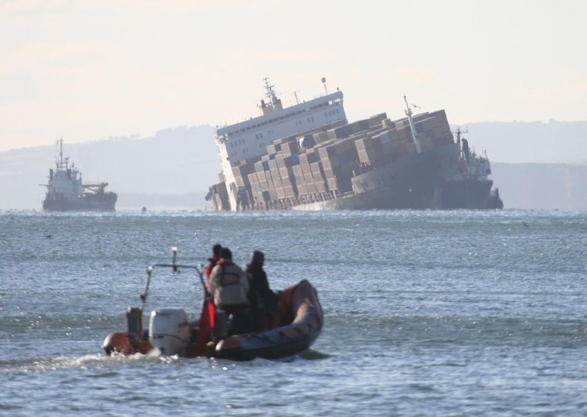
In February 2011, the United States Coast Guard assisted a disabled 432-foot ocean
targeted response to distress notifications, by freighter just outside of Cape Cod, Massachusetts. The MV Dintelborg lost propulsion
when a small fire broke out on the bridge and the ship went adrift without power in 16-
providing:
foot seas with no ship to shore communications. The Tug McAllister (exactAIS track shown
above) came in to assist in the rescue and towed the Dintelborg to safety.
Vessel identification and last known position;
Rapid identification of ships in vicinity of distress;
Tracking of drifting vessel from distress call location;
Proactive notice to SAR coordinators of ships entering remote coverage zones; and
Identification of projected track based on last known position, course and speed.
“Satellite based AIS has now become a critical infrastructure component for all Maritime Safety Authorities,
providing advanced reporting and wide area monitoring for all the world’s oceans. In S-AIS data, you get course over
ground information (the direction in which it's moving) and heading (the direction the ship's pointing). These can tell
you a lot about what a ship is doing. You may remember the Costa Allegra, which had a fire about two weeks after its
sister ship, the Costa Concordia, ran aground. The fire knocked out the engine and the ship started drifting, and you
could see this in the S-AIS. The ship went side on in the current, but its heading was about 90 degrees different. So
just by looking at the AIS data, you could tell there was something wrong with the vessel. "
-John Allan, Vice President of Global Sales and Marketing for exactEarth.
While SAR programs like GMDSS can track ships on a global scale and use the information to provide search and rescue
assistance to vessels well beyond coast guard helicopter range, they will undoubtedly benefit from improved, real-time data.
For vessels in distress, S-AIS can identify exactly where a vessel is located anywhere in the world even if it continues to drift far
from its initial distress location. Access to accurate, reliable and timely data about the status of a vessel and its crew can greatly
reduce response time by focusing rescue resources to a more refined area and by providing enhanced overall rescue
coordination to save lives. S-AIS can also track rescue teams and reduce the risk to rescuers, especially in harsh weather
environments.13
“Although AIS was never designed as a tool for Search and Rescue, space-based AIS has quickly become a useful tool for
Maritime SAR Mission Coordinators to determine potential responders in the area of a casualty. After selecting the most
capable resources they can cross reference the MMSI numbers and call the ships directly and issue tasking instructions.”
- Captain Jack Gallagher (CCG (Retired)- Hammurabi Specialist SAR & Marine Safety Consultants)
12) http://www.sea-technology.com/features/2011/0311/ais_system.php
13) http://gcaptain.com/satellite-launches-track-european/
Copyright ©exactEarth Ltd, 2013. All Rights reserved. Page 4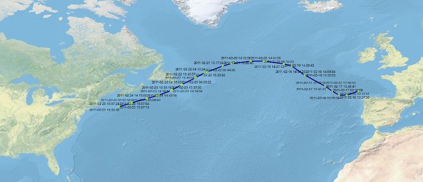
When dealing with maritime SAR, the most important use of S-AIS is to determine what vessels are closest to the vessel or
incident. Vessels today are equipped with GMDSS and EPIRB beacons that transmit a distress signal. S-AIS provides an immediate
and accurate picture of all ships close to the distressed vessel, allowing SAR authorities to contact these vessels and direct them to
provide assistance.
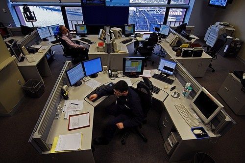
S-AIS within Maritime Rescue Coordination Centres
Even in very dense shipping areas, this operationally proven technology
offers an actionable and NRT picture perspective that is particularly
useful when it comes to creating and verifying global maritime-traffic
movements for SAR and VTS authorities. The exactEarth satellite
constellation of polar orbiting satellites has provided over two years of
continuous global coverage of vessel positions, routes and traffic
patterns for commercial and government customers alike. The
exactView™ system currently detects over 40,000 vessels per day, and
when the satellite constellation is fully deployed, it will detect nearly all Inside the USCG’s Maritime Rescue And Coordination Center in Boston.
Photo courtesy of gCaptain.com
ocean-going vessels on a daily basis. Additionally, exactAIS is increasingly
detecting messages from lower-power Class B transponders on an increased level. With recent additions to the exactEarth
constellation, Class B detections have risen nearly 30 percent giving unprecedented visibility for the thousands of smaller vessels
worldwide. The ability to detect both Class A and B transponders will make accessing the system all the more attractive for SAR
MRCCs and VTS alike.
S-AIS could also help MRCC’s resolve false alarms received from vessels when distress alerts were accidentally or inadvertently
transmitted from their safety equipment, such as a Satcom terminal, DSC radio or EPIRB.
In short, using S-AIS for SAR operations translates to the following benefits:
Saving lives
Reducing response time
Focusing resources to a refined search area
Better tracking of first responders
Re-deploying savings to other operational uses
In operational SAR scenarios, S-AIS heightens authorities' MDA:
Providing near real-time data that can be correlated with other data sources
Improving the accuracy of vessel identification
Allowing for earlier detection for dark targets (non-transmitters) to be identified more readily
Improving track validation
Aiding the coordination of rescue efforts
Copyright ©exactEarth Ltd, 2013. All Rights reserved. Page 5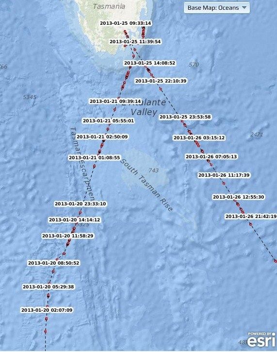
S-AIS Search and Rescue Case Studies
1) Australian Maritime Safety Authority (AMSA)
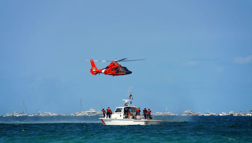
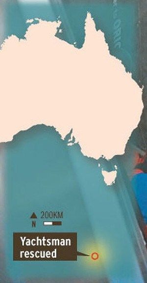
In January 2013, the Antarctic cruise ship Orion
successfully recovered a solo sailor who had spent 56
hours in a life raft in the Southern Ocean after his yacht
was de-masted in rough weather. Although, the
recovery operation only took one hour, the entire
rescue operation lasted three days, and involved five
aircraft that maintained near-continuous
communication with the sailor while PV Orion made its exactAIS tracking of the Orion as it diverted
way towards the life raft. After making contact with the its course to assist in the rescue operation of
a stranded French sailor in the Southern
sailor, who did not declare he was in distress at the Ocean
time, AMSA advised him to head towards Hobart,
Tasmania. Hours later, AMSA detected an emergency
beacon activation from the sailor 500 nautical miles south west of Hobart at which point AMSA issued a broadcast to the PV
Orion, which at the time was more than 600 nautical miles from the position of the yacht. The Orion then diverted course to
begin the 60 hour journey to the life raft where the experienced sailor had been at sea for
several months.
This particular case highlights the difficulties SAR forces encounter with on-scene
communications in order to complete rescue operations. When the cruise ship Orion got to
within a mile of the life raft, it still had to be guided to the life raft's location by smoke and light
floats that were dropped on-scene by a RAAF Hercules aircraft. The commercial rescue ship
Orion could not communicate directly with the survivor in the life raft, nor see his position on
any ship display, even though all had various communications devices:
the sailor in distress had an EPIRB that transmitted a distress radio signal on two
frequencies: homing signal at 121.5 MHz and distress alert signal at 406 MHz
the 121.5 MHz could be received by near-by rescue RAAF plane, but not by the cruise ship
Orion
the Orion could transmit and receive AIS signals, had an EPIRB for distress, and had radio
communications equipment to communicate in the maritime frequency band (156-162 MHz)
Satellite AIS data from exactEarth was able to play an integral role in this operation however by providing AMSA authorities with a
complete and up-to-date picture of the area around the distress signal as well as information on all vessels and their status within
the vicinity of the incident. AMSA was then able to quickly act to alert the Orion to help facilitate the rescue as they selected the
most appropriate vessel to proceed to the distress call.
exactEarth data provides the current status of a ship, and can be used to help the selection of the most appropriate rescue vessel
in the vicinity. This ensures that authorities can best utilize resources in the area for a quicker rescue operation.
Copyright ©exactEarth Ltd, 2013. All Rights reserved. Page 6
2) The Indian Coast Guard

 The Indian Coast Guard is the principal agency for protecting, monitoring and enforcing the maritime zones of India. exactEarth
 has been providing exactAIS data to the Indian Coast Guard for over two years and it is proven very helpful in their daily SAR
 efforts in locating the nearest ship to an incident instantly, as the position updates are more frequent, according to Rama Rao the
 Officer in Charge at the Maritime Rescue Coordination Centre in Mumbai. In certain cases, exactAIS has been the main source of
 identifying the ships involved in a collision off the Indian coast.

 The main challenge facing India is the approximately one million fishing boats that do not have any sort of alerting device on
 board. Rao hopes in future to be able to establish a low cost AIS alerting device for all of their fishermen and believes it’s high
 time to recognize that Satellite AIS is wildly effective both cost wise and application wise compared to DSC devices, the current
 method to initiate emergency communications with ships and rescue coordination centers. “Recently, India commissioned a
 National AIS chain covering our entire coastline with base stations”, stated Rao. “I believe that establishing an AIS and an S-AIS
 alerting system would be most ideal for our operations and would grossly reduce our SAR efforts.”

 Future S-AIS SAR Developments

 At the World Radio Conference (WRC) in Feb 2012, the International Telecommunication Union (ITU) approved the allocation of
 two new specific AIS channels for satellite detection of AIS, ushering in a new phase for AIS and recognizing it as a viable
 technology that is positioned to support future developments such as inclusion in the next generation GMDSS, small vessel
 tracking and possibly even inclusion into the IMO Long Range Identification and Tracking (LRIT) system for vessel tracking. 14 The
 new S-AIS channels will becomes known as the AIS Tracking Channels.15

 More recently, the IMO has approved transmissions by AIS-SART (Search and Rescue Transmitter) devices. These devices were
 originally designed for SOLAS class ships as an alternative to radar SARTs for carriage on lifeboats. 16 The recent decision by the ITU
 to set aside two channels for satellite detection of Class ‘A’ AIS devices means these channels can be used by a wider range of AIS
 devices, such as AIS man-over-board devices. These new AIS units are typically much lower-power devices so they will need
 adjustments for consistent detection from space. These adjustments could range from modulation to protocol changes, areas
 which exactEarth is already researching for future applications. Whatever technological changes are required, it should be
 recognized that S-AIS detection is no longer perceived as a "nice to have," it is a "must have". 17

 AIS technology is increasingly being deployed in smaller vessels and is also being installed in Aids-To-Navigation (AtoN) and SARTs.
 It is effectively expanding on the options offered by the already established GMDSS and AMVER systems for initially identifying
 vessels in distress (the search) and subsequent allocation of resources (the rescue).

 There are also many potential uses for S-AIS within SAR operations and it is worth discussing some of the solutions using AIS that
 are now available. SART devices can now be carried in a life raft to transmit an AIS signal with a GPS position that can be
 displayed on the AIS screens on all ships in the vicinity. It would also appear as a distress signal at a specific location which could
 have immensely improved the situation of the French sailor.

 The possibility of AIS transmitters being built into future EPIRBs has also sparked interest in the maritime SAR community. These
 devices would transmit a similar signal as the AIS-SART to allow the EPIRB to transmit three distress signals to all three types of
 recipients: Satellite, nearby SAR aircraft and airliners as well as all nearby large vessels equipped with AIS receivers.

    14)   http://exactearth.com/media-centre/exactblog/ Peggy Browning December 14, 2011
    15)   http://exactearth.com/media-centre/exactblog/ Peggy Browning January 4, 2012
    16)   AIS SART Sea Trials– BMW (2010) Presented by J. King
    17)   http://exactearth.com/media-centre/exactblog/ Peggy Browning May 2, 2012

Copyright ©exactEarth Ltd, 2013. All Rights reserved.                                                                            Page 7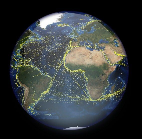
Conclusion

   One hundred years on from the sinking of the Titanic, the rise of globalised trade sees thousands of ships transit the Global
   Ocean Commons on a daily basis. Around the world SAR activities are initiated daily from the frozen poles to the equatorial
   tropics, as part of a multi-faceted mandated enforcement campaign designed to preserve life, maintain marine safety and
   protect the environment. The more accurate MDA offered by S-AIS provides shore-side authorities with a better
   understanding of the who, why, what and where, all of which promotes a more comprehensive risk and vulnerability analysis
   for SAR resource planning. The recent establishment of dedicated S-AIS channels by the ITU shows the value of this exciting
   technology and recognition of its significant contribution to the future of marine safety and in particular SAR. S-AIS has to be
   seen as big a step forward for the MDA aspects of SOLAS, just as GMDSS was to its communications aspects. In order to
   minimize the resources, time and effort spent in SAR operations, S-AIS has to be considered a vital part of the solution.

Copyright ©exactEarth Ltd, 2013. All Rights reserved.                                                                           Page 8
You can also read