AUSTRALIAN BUREAU OF METEOROLOGY CONTRIBUTION TO IMPROVING THE QUALITY OF FLASH FLOOD WARNING INFORMATION
←
→
Page content transcription
If your browser does not render page correctly, please read the page content below
AUSTRALIAN BUREAU OF METEOROLOGY CONTRIBUTION TO
       IMPROVING THE QUALITY OF FLASH FLOOD WARNING
                       INFORMATION

Karen Hudson1, Johan Veldema1, Daniel Burton1, Grant Wilson1, Dasarath Jayasuriya1,
Soori Sooriyakumaran1, Nicole Pana1
1
Hazards, Warnings and Forecasts Division, Bureau of Meteorology

Abstract

Flash flooding is well recognised as a potential threat to life and property. The risk is
further exacerbated by increased urbanisation, a challenge faced globally.

The Standardisation of Bureau of Meteorology Hazard Services Taskforce set up under
the Australia New Zealand Emergency Management Committee (ANZEMC) has endorsed
that the prime responsibility for local flash flood warnings lies with the States and
Territories in partnership with local government (where appropriate) within their
jurisdictions. The Bureau will support this role by continuing to work actively with local
governments to advise on the development of flash flood warning systems and
procedures.

The Bureau’s role is mainly in the provision of weather warnings leading up to flash
flooding and through the provision of radar observations. The Bureau also provides a data
collection system named Enviromon to help local councils and state and territory agencies
with responsibility for flash flood warning to collect rainfall and water level data to support
their warning obligations.

This paper will discuss the Bureau’s recent initiative to set up a National Flash Flood
Information Repository (NFFIR). The NFFIR helps to address a recognised knowledge gap
amongst responsible agencies by providing an authoritative source of information
regarding the design, development and operation of state of the art flash flood monitoring
and warning systems in Australia and abroad.

The NFFIR will provide a general advisory service from subject matter experts at the
Bureau through telephone or email.

The NFFIR will also provide registered user access to a web portal to designated local
council staff and agencies with flash flood warning responsibilities. This web portal will
provide authoritative information on monitoring and communication networks including on
standards, setting up and maintaining flash flood warning systems, case studies, and also
how to access and best use Bureau observations and forecasts.

2016 Floodplain Management Association National Conference                                        1
Introduction

Flash floods continue to be a significant cause of death and injury, both in Australia and
worldwide, and a major source of property damage. During 2010-11, a significant number
of deaths were attributed to flash flooding in Queensland. Subsequently, the Interim
Report (2011) of the Queensland Floods Commission of Inquiry made a number of
findings related to flash flood management. Among them was the need to recognise the
lack of capacity in some local councils to interpret and communicate information from the
Bureau for flash flood warning. Another was the need for the Bureau to communicate more
directly with local councils in relation to flash flood warnings. The Comrie review into the
Victorian floods of 2010/2011 also identified a number of gaps and inconsistencies in
responsibility for and issuing of flash flood warnings. The Australian Government, in
responding to these recommendations, took into consideration that the Bureau is required
to provide consistent national services across the country and also to have the capacity to
deal with priorities and extreme weather situations as they occur anywhere across
Australia.

Accordingly, in July 2011 the Commonwealth Government announced a review of the
capacity of the Bureau of Meteorology to respond to future extreme weather and natural
disaster events and to provide accurate and timely seasonal forecasting services (Munro
Review, 2011). This review, carried out by Ms Chloe Munro, identified several priority
actions and several options to guide improvements through a set of recommendations.

Priority Action 4 recommended that clear allocation of responsibilities should be made for
state and local government for flood management, with defined boundaries on the
Bureau’s role, and to clarify roles and responsibilities for issuing flash flood warnings.

In consideration of the cross jurisdictional nature of this and other recommendations that
affected the Bureau service, in October 2013, the Standardisation of Bureau of
Meteorology Hazards Services Taskforce was established by the Australia – New Zealand
Emergency Management Committee (ANZEMC) to address key priority actions of the
Munro Review. The taskforce recommendations were reported to and accepted by
ANZEMC, and in turn reported to and accepted by the Law, Crime and Community Safety
Ministerial Council (LCCSC), in May 2015.

The taskforce’s recommendations are detailed in the Standardisation of Bureau of
Meteorology Hazards Services Taskforce final report (May 2015). This report also includes
an action plan for flood services — the basis of the current ANZEMC flood programme of
projects being managed by the Bureau of Meteorology.

One of the recommendations of the Standardisation of Bureau of Meteorology Hazard
Services Taskforce is for the Bureau to establish a National Flash Flood Information
Repository (NFFIR) as part of its support role to local government and emergency service
agencies with responsibilities in flash flood warning and response. The primary aim of the
NFFIR is to be an authoritative source of technical information and advice on flash flood
monitoring and warning systems. This will help responsible agencies, and through them
the community, to increase their resilience to flash floods through better preparation and
more effective response to the floods when they occur.

2016 Floodplain Management Association National Conference                                     2
What is flash flooding?

Flash floods can occur almost anywhere, and usually result from a relatively short, intense
burst of rainfall, typically caused by severe storms and convective weather systems.
During these events the drainage system may be unable to cope and flow frequently
occurs outside of defined water channels.

Areas with low-capacity drainage systems, whether natural or artificial, are particularly
vulnerable to flash flooding. Although flash floods are generally localised, they pose a
significant threat to human life, because of the high flow velocities and rapid onset.

In Australia, flash floods are normally defined as those floods that occur within six hours of
the causative rainfall event. Due to their localised nature, the observation of these events
with a gauging network is problematic; accurate monitoring and prediction of severe storm
rainfall events to inform effective warnings continues to be a major challenge.

Flash flooding can be divided into two key categories:

•       Rapid response catchments - urban creeks and steep rural creeks in the
        headwaters of river catchments where the response time to heavy rainfall is very
        short (less than 6 hours);
•       Overland flooding - intense heavy rainfall in any area which overwhelms the local
        stormwater drainage system or the ground's capacity to absorb rainfall, causing
        flooding across the land.

Bureau’s meteorological warnings to support flash flood management

The Bureau provides Severe Weather and Severe Thunderstorm Warnings, both of which
can include advice regarding the potential for heavy rainfall leading to flash flooding.

Severe Weather Warnings are issued whenever severe weather is occurring in an area or
is expected to develop or move into an area. The warnings describe the area under threat
and the expected hazards. Warnings are issued with varying lead-times, depending on the
weather situation, and range from an hour or two ahead up to about 24 hours.

Severe Weather Warnings are issued based on one or more of the following criteria:

    •   Sustained winds of gale force (63 km/h) or more;
    •   Wind gusts of 90 km/h or more (100 km/h or more in Tasmania);
    •   Very heavy rain that may lead to flash flooding;
    •   Abnormally high tides (or storm tides) expected to exceed highest astronomical
        tide;
    •   Unusually large surf waves expected to cause dangerous conditions on the coast;
    •   Widespread blizzards in Alpine areas.

Severe Thunderstorm Warnings are issued to alert communities to the threat of particularly
dangerous thunderstorms. Severe thunderstorms can cause significant localised damage
due to damaging wind gusts, large hail, tornadoes and flash flooding. A severe
thunderstorm is defined by the Bureau as one which produces one or more of the
following:
2016 Floodplain Management Association National Conference                                       3
• hail with a diameter of 2 cm or more;
• wind gusts of 90km/h or greater;
• heavy rainfall which may cause flash flooding;
• tornadoes.
The Bureau issues a Severe Thunderstorm Warning when a severe thunderstorm is
detected or when there is strong evidence of the formation and persistence of it or if
existing thunderstorms show the potential to develop into a severe thunderstorm. These
warnings typically include information on expected phenomena (large hail, dangerous
winds etc), the area of the threat and safety action statements to the community usually
provided by emergency services.
Severe thunderstorms are usually quite localised, develop quickly and their exact location
can be hard to predict. As a result, lead-times for the warnings are often short. Severe
thunderstorms affect smaller areas and fewer people than tropical cyclones and riverine
floods, but are more common and frequent with their combined impact quite significant.
There are 3 types of Severe Thunderstorm Warnings issued by the Bureau:
• Detailed - for the densely populated cities and surrounding areas, particularly in the
east. They are issued when individual severe thunderstorms are within range of the
Bureau's weather-watch radars. They provide more specific information on
individual severe thunderstorms. The warning includes a map depicting any
existing thunderstorms and the forecast direction of movement for up to 60 minutes
• Broad-based - issued for the entire state or territory affected, these will usually be
less detailed. They are issued as an alert to the public, emergency services and
other organisations that severe thunderstorms are likely to develop, or extend into,
a specified area over the next few hours. They are based on broad areas such as
the Bureau's weather forecast districts. They include a map with the areas covered
by the warning shaded in yellow.
• Text-based - issued in Western Australia and the Northern Territory (with the
exception of Darwin).
Severe thunderstorm and severe weather warnings are provided from the Bureau's
regional forecasting centres. To prepare the warnings, forecasters use Numerical Weather
Prediction (NWP) computer model predictions, combined with data from satellites, radar,
lightning detection networks and data from observation stations. The Bureau also receives
reports from a network of 3000 volunteer storm spotters that help by being “eyes on the
ground”.
Bureau's new supercomputer
The Bureau's new supercomputer, named Australis, is expected to begin operation in 2016
and will result in forecasts and warnings being:
• More accurate
• More up to date
• More certain
• More responsive
2016 Floodplain Management Association National Conference 4The new supercomputer will enable the Bureau to provide more accurate and localised
weather information, particularly to support public safety in severe weather events such as
thunderstorms, bushfires, floods and tropical cyclones. The increased computing power
means that the Bureau has the ability to run the complex NWP models used to forecast
weather at a higher resolution, as well as more often to allow more frequent forecast
updates in extreme weather situations. The use of higher resolution ensemble forecasts
will also help to reduce uncertainty by providing increased ability to quantify the probability
of forecast outcomes for decision-makers.
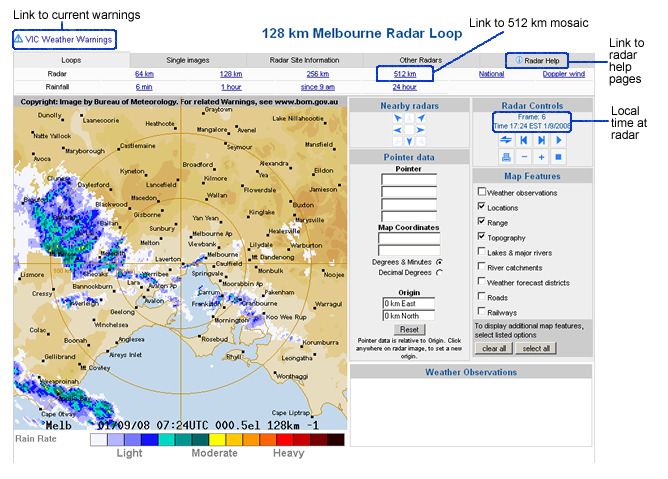
Australian Weather Watch Radar
The Bureau operates a nationwide network of over 60 Weather Watch radars and is an
international leader in radar rainfall research. The radar viewer on the Bureau website is
available for all radars in the Bureau's network, and allows users to customise the map to
display features near to their location to assist with locating rainfall during an event.
Weather Watch radars are very effective tools for the detection of rain. Bureau forecasters
can interpret the patterns and intensity of the radar images to provide warnings of major
weather events such as severe thunderstorms, tropical cyclones and areas of heavy
rainfall. Specialised analysis and display tools have been developed at the Bureau for
radar data providing valuable information to thunderstorm forecasters on rainfall intensity
and how and where the thunderstorm is tracking.
Figure 1: Example image from the Bureau's Radar Viewer
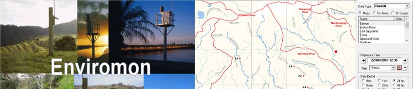
2016 Floodplain Management Association National Conference 5Provision of the Enviromon data collection system
The Bureau developed an in-house Windows-based application, Enviromon, to enable
data collection and management from field devices. This was developed specifically to
meet the needs of many agencies involved in environmental data collection at the local
level. The software has been developed with sufficient flexibility to collect data of various
types, although currently its main use is to collect data from Event-reporting Radio
Telemetry Systems (ERTS). ERTS technology is used widely throughout Australia to
monitor rainfall and river levels by various local government agencies and state water and
emergency management agencies involved in flood management.
Enviromon can be installed either on a standalone computer or as a client/server
application on a networked computer. The Bureau can provide a range of supplementary
services associated with Enviromon including: installation of Enviromon software, desktop
and field-based radio-path testing, commissioning of an Enviromon base station,
maintenance and support, and on-site Enviromon training.
Enviromon allows the users to perform a number of key functions:
• Monitor incoming data in real time;
• View sensor data either through map view, graphical view and tabular views;
• Send automated alerts to users when pre-defined system or rainfall/river level
threshold conditions occur;
• Prepare reports of data collected;
• Export or import data to/from other Enviromon systems;
• Manage the metadata;
• Manage incoming and outgoing data including forwarding data through the Internet.
Figure 2: Real-time monitoring using Enviromon
2016 Floodplain Management Association National Conference 6National Flash Flood Information Repository (NFFIR) This paper focusses on the development of the National Flash Flood Information Repository (NFFIR), recommended by the Standardisation of Bureau of Meteorology Hazard Services Taskforce and subsequently accepted as a recommendation by ANZEMC and the Ministerial Council responsible for community safety. What is the NFFIR? The NFFIR will deliver two key components to local government, emergency services and other State and Territory agencies. The two components of the NFFIR – the web-portal and the advisory service - are intended to complement each other. They follow a similar concept to the WMO HelpDesk for Integrated Flood Management, which features "Get Help" and "Help Yourself" functions. Users have the option to request custom-made technical support through the "Get Help" function or to find flood management solutions for themselves using the literature in the "Help Yourself" section. Both components of the NFFIR will be fully supported by the Bureau of Meteorology into the future. Registered-user web portal The registered-user web portal will bring together a comprehensive store of up-to-date and easily accessible technical information on the standards, design, development and operation of flash flood monitoring and warning systems in Australia. The web-portal is intended as a dynamic resource that will continue to evolve and improve over time to ensure it remains relevant and includes the latest available information. Advisory service The advisory service, provided through a dedicated telephone number and email address, will allow direct access to Bureau staff with technical expertise in the design and development of flash flood warning systems and services. This is not an operational service and advice will be available during business hours only. The Bureau will continue to provide severe weather and severe thunderstorm warnings, indicating potential for flash flooding, as per current practice. Who is the NFFIR for? The NFFIR is intended for local government and emergency services, plus other State and Territory agencies, with responsibility for flash flood warnings and response. Intended audience groups include: • Local government — managers 2016 Floodplain Management Association National Conference 7
•       Local government — operational staff
   •       State government agencies
   •       Emergency services
   •       Catchment management authorities

The NFFIR is expected to be of greatest benefit in areas where there is high flash flood
risk coupled with agencies who have limited experience of setting up and operating flash
flood warning systems.

The NFFIR will not be publicly available; it will only be accessible for registered users from
the above categories and is not expected to function as an operational service during a
flash flood event.

Benefits

The primary aim of the NFFIR is to be an authoritative source of technical information and
advice on flash flood monitoring and warning systems. It is intended to be readily
accessible to all responsible agencies, providing guidance on installation of appropriate
systems tailored to specific risks. Ultimately this should help responsible agencies, and
through them the community, to increase their resilience to flash floods through better
preparation and more effective response to the floods when they occur.

Specific benefits expected to flow from establishing the NFFIR are:

   •   Modern, efficient and fit-for-purpose flash flood warning systems through ready
       access to relevant, comprehensive and up-to-date information;
   •   Reduced costs of flash flood warning systems through the adoption of nationally
       consistent standards and availability of proven technical solutions;
   •   A notable reduction in deaths and damages attributable to flash flooding in
       Australia.

NFFIR web-portal

The NFFIR's registered-user web portal will be hosted on GovDex; a secure, online
collaborative space hosted by the Department of Finance, where registered users can
easily access information. A key requirement for NFFIR is that relevant information on
flash flooding and flash flood early warning systems is continually updated, as new
information becomes available. For maximum benefit to all users, the NFFIR needs to
remain as current as possible.

The NFFIR web portal is in the early stages of development, with the initial site map
design organised as follows (see Figure 3 and Table 1 below):

2016 Floodplain Management Association National Conference                                       8
Figure 3: NFFIR Preliminary Site Map Design
Theme Description
About NFFIR Containing background to the project and details of NFFIR's aims and
objectives.
• Mission Statement NFFIR's principal aims, i.e. to ensure
appropriate/sustainable flash flood (early warning) solutions are being
used by State and Local Government to effectively warn the general
public.
• Definition(s) Definition of flash flooding; (i) riverine flash flooding and
(ii) overland flooding.
• Roles and responsibilities To reinforce roles and responsibilities for
flash flooding.
• Stakeholders/Intended Audience To include discussion on
sponsors, key players, target audience
• Glossary Comprehensive glossary of terms, linked to the Australian
Water Information Dictionary (AWID).
• Frequently Asked Questions Building FAQ based on feedback and
queries received through the advisory service (telephone and email).
2016 Floodplain Management Association National Conference 9Theme Description
Background Facts/Figures/History
Providing an overview of the impacts of flash floods across Australia and
overseas, including anecdotal information and high level figures on
social/economic/environmental impacts etc. This section will also include a
register of historical flash flood events and incidents, which will be updated on
a regular basis into the future.
International Practices
Information on current international practices related to flash flooding and flash
flood early warning systems, including globally (WMO), USA (National
Weather Service), UK (Environment Agency, Scottish Environment Protection
Agency).
Standards/Guidelines
Reference material, to cover:
• Data collection/instrumentation
• Risk assessment - how to assess and manage risk
• The Total Flood Warning System (Manual 21)
• Legal framework, covering insurance and planning guidelines
The National Flood Warning Infrastructure Working Group (WG) has recently
been set up under ANZEMC to develop risk based, standard compliant
strategic plans for flood warning infrastructure focusing on the monitoring and
prediction elements of a total flood warning system. The aim is to ensure
sustainable provision of data essential to underpin flood warning services
nationally – in both the riverine and flash flood space. Investments will be
prioritised objectively using a nationally acceptable framework, based on
consistent assessment of risks, leading to systems being put in place that are
fit-for-purpose.
2016 Floodplain Management Association National Conference 10Theme Description
Flash Flood Case Studies
Solutions
Including a register of currently available flash flood early warning systems
throughout Australia, plus more detailed case studies of selected operational
flash flood early warning systems.
The case studies are expected to provide a range of examples of the types of
flash flood problems faced by local government authorities and the
approaches adopted to address them. Lessons learned and details such as
the rationale behind the system, how it has been set up, communicated to the
public and incorporated into emergency response planning will inform future
decision making by state and local agencies.
A case study questionnaire has been developed, based around the elements
of the total flood warning system, and will be used to gather responses in
consultation with stakeholders. Completed responses will be developed into
case studies by the NFFIR project team to ensure a consistent look and feel.
Flash Flood Solutions – Decision Support
Decision support on solution options for flash flood problems. This will
comprise tiered, end-to-end solutions, following the elements of the Total
Flood Warning System. Choice of the appropriate solution to address a
specific problem should be based on the level of risk to the community.
Library
A register of references, to include relevant books, papers, manuals and
reports.
Webinars
Advertising of upcoming webinars (organised by the NFFIR advisory service)
and access to an archive of previous webinars and presentations.
2016 Floodplain Management Association National Conference 11Theme Description
Useful Links to relevant products available within the Bureau, including:
Resources
• Himawari Products offered through the Himawari Satellite, including
rainfall, soil moisture, real-time flood observations and imagery.
• Radar Radar rainfields, STEPS
• MetEye Tailored links to MetEye products of particular interest to
operational local and state government officers, such as latest rainfall,
chance of rainfall. MetEye is a particularly useful tool to enable
agencies and members of the public to quickly focus in on the
observed and forecast weather for their specific local area.
• Intensity-Frequency-Duration (IFD) web-page To assess the
severity of specific observed rainfall totals compared to historic
records.
• Rainfall and river conditions Maps and tables of latest observations.
• Potential future products Details of the Flash Flood Guidance and
Rainfall/River Alerts products being developed by the Bureau as part
of the HyFS 2020 project.
Regional A page for each State and Territory to detail:
Pages
• Local arrangements for flash flooding
• Funding mechanisms
• Relevant jurisdictional policies or strategies
Contacts • How to submit feedback and questions
• Discussion forum
• Advisory service
Table 1: NFFIR preliminary site map design
Project funding and timelines
Funding has been secured for 2015–16 through the National Emergency Management
Projects (NEMP) programme. This funding will allow the Bureau to complete Stage 1 of
the project, comprising development of the advisory service and registered user web-
portal. NEMP funding for the project was announced in August 2015. The funding
agreement between the Attorney-General's Department (AGD) and the Bureau of
Meteorology was signed in early January 2016, with a completion date for the project of
1 September 2016.
Funding is also being sought for Stage 2 of the project (yet to be confirmed), which will
have a greater emphasis on stakeholder engagement and communication to ensure
effective adoption of the NFFIR by local government and emergency services agencies.
2016 Floodplain Management Association National Conference 12Stage Description
This stage will comprise establishment of the advisory service for the
NFFIR and also research and development of the content for the
registered user web-portal. The advisory service will be available by the
end of April 2016, with the web-portal available for registered user
Stage 1
access by 1 September 2016.
NFFIR development
Stakeholder engagement will start during this stage, in particular in
defining service requirements with agencies experienced in flash flood
(Jan –Sep 2016)
issues but also in 'road-testing' the initial web-portal layout and content.
In addition to the key deliverables identified above, procedures for
managing registered users and the ongoing maintenance of the web-
portal should also be defined as part of this stage.
Stage 2 This stage will build on the stakeholder engagement activities started
during Stage 1 and expand them to incorporate all jurisdictions. The
Enhanced intent will be to conduct regional roadshows and targeted training to
communication and ensure that the NFFIR can fully realise its expected benefits.
adoption
Further development and enhancement of the NFFIR web-portal will also
(Sep 2016 – Jun 2017) continue during Stage 2, subject to approval of funding.
Table 2: NFFIR project stage plan
Stakeholder engagement and quality assurance
Successful development and ongoing operation of the NFFIR depends heavily on
appropriate engagement of key stakeholders, both internal and external to the Bureau.
Stage 1 of the project is necessarily more focused on development of the NFFIR rather
than extensive communication and adoption, however it is essential that users have input
into defining their requirements for the web-portal and advisory service.
Details of the project advisory and working groups established as part of Stage 1 are
presented in the following sections.
Reference Panel
A reference panel of representatives and subject matter experts, from State Government
agencies with flash flooding as a key risk in their jurisdictions, has been established for the
project. The reference panel members are from New South Wales, Victoria, South
Australia and Queensland. The reference panel also includes representation from the
Bureau's Flood Forecasting and Warning Operations and Strategy & Policy teams and is
chaired by the Bureau's Assistant Director Water Forecasting Services, Jaya Jayasuriya.
2016 Floodplain Management Association National Conference 13The role of the reference panel is to provide guidance to the project team and support development of the NFFIR from first concept through to implementation. The reference panel will review technical content as it is developed and contribute to the success of the NFFIR by ensuring users' needs are considered and met. Regional Workshops Stakeholder consultation workshops are planned in New South Wales, Victoria, South Australia and Queensland during late April and early May. The aim of these small, targeted workshops, comprising a range of selected users from across the intended audience groups, is to consult users on their requirements for the NFFIR. The workshops will be used to gain insight into local flash flood issues faced by jurisdictions, and gather feedback on the proposed content and design of the web-portal. Bureau Project Working Group An internal project working group, comprising representatives from each of the Bureau's State and Territory Flood Forecasting and Warning teams plus a representative from the Head Office Modelling team, has been established for the project as part of the internal project governance structure. The working group is providing invaluable input to the project through their local insight and knowledge, and gathering of information to feed into the case studies and registers of flash flood early warning systems and flash flood history. How to get involved All stakeholders and potential users with a role in flash flood warning and response are encouraged to get involved in the development and testing of the NFFIR. The effectiveness of the NFFIR will be highly dependent on the involvement of stakeholders to improve the quality and quantity of information included, both now and into the future. To register your interest please email: nffir.support@bom.gov.au Acknowledgements The Bureau would like to thank NEMP for providing the funding for 2015-16 to enable the development of NFFIR to take place. The Bureau would also like to thank everyone who has been involved with the project so far through the provision of valuable advice and information. This includes the project Reference Panel, external stakeholders involved in the stakeholder consultation workshops and many internal representatives from across the Bureau's regions and teams. 2016 Floodplain Management Association National Conference 14
References

Attorney General’s Department (2009), Australian Emergency Manual Series – Manual 21
Flood Warning, Commonwealth of Australia, Canberra.

Attorney General’s Department and Bureau of Meteorology (2015) Standardisation of
Bureau of Meteorology Hazards Services Taskforce: Final Report, Commonwealth of
Australia, Canberra.

Comrie, N (2011) Review of the 2010-11 Flood Warnings & Response: Final Report,
Victorian Government, Melbourne.

Munro, C (2011) Review of the Bureau of Meteorology’s capacity to respond to future
extreme weather and natural disaster events and to provide seasonal forecasting services;
an independent report commissioned by the Department of Sustainability, Environment,
Water, Population and Communities, Commonwealth of Australia, Canberra.

Queensland Floods Commission of Inquiry (2011): Queensland Floods Commission of
Inquiry: Interim Report, Queensland Government, Brisbane.

Queensland Floods Commission of Inquiry (2012): Queensland Floods Commission of
Inquiry: Final Report, Queensland Government, Brisbane.

World Meteorological Organisation – HelpDesk for Integrated Flood Management.
http://www.apfm.info/?page_id=1253

2016 Floodplain Management Association National Conference                              15
You can also read