Early Warning Communication for Enhanced Anticipatory Disaster Risk - The Status of Flood Early Warning Communication in Lower Tana and Athi Basins
←
→
Page content transcription
If your browser does not render page correctly, please read the page content below
Early Warning Communication for
Enhanced Anticipatory Disaster Risk

    The Status of Flood Early Warning
    Communication in Lower Tana and
    Athi Basins
Authors:   Oscar Lino   Emmah Mwangi   Mark Arango   Halima Saado Abdillahi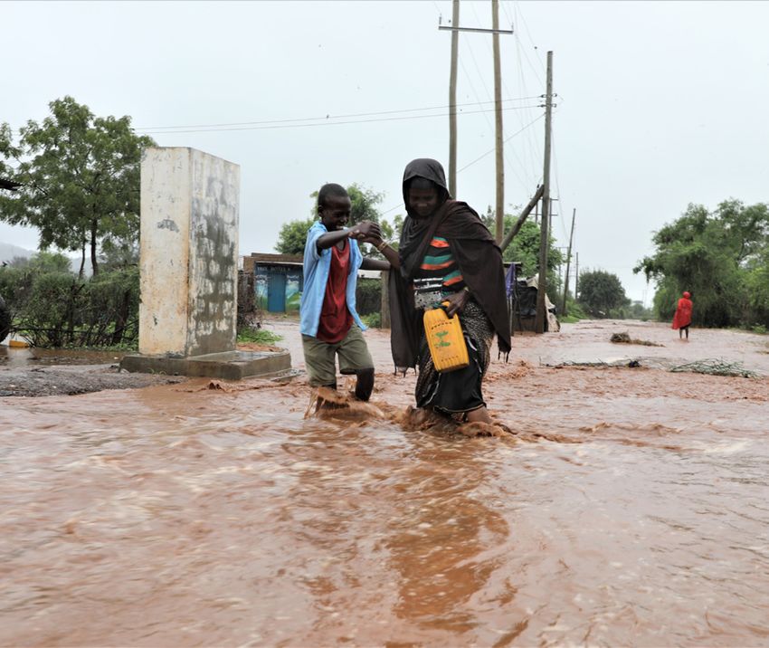
Occasional Paper Series No. 2

    Table of Contents
    Abstract .....................................................................................4
    1.0 Background...........................................................................5
       1.1 Introduction ......................................................................5
       1.2 Area of study......................................................................7
       1.3 Objective and Methodology................................................8
    2.0 Results.................................................................................10
       2.1 Trends and impacts of weather and climate hazards............10
       2.2 Types and sources of early warning information.................11
       2.3 Communication of Early Warning information.....................12
          2.3.1 Channels ...................................................................... 12
          2.3.2 Frequency / lead time................................................... 13
       2.4 Challenges and gaps in communication of early warning
       information .............................................................................14
    3.0 Discussion............................................................................16
    4.0 Conclusions ..........................................................................17
    5.0 Recommendations.................................................................18

2   Early Warning Communication for Enhanced Anticipatory Disaster Risk Management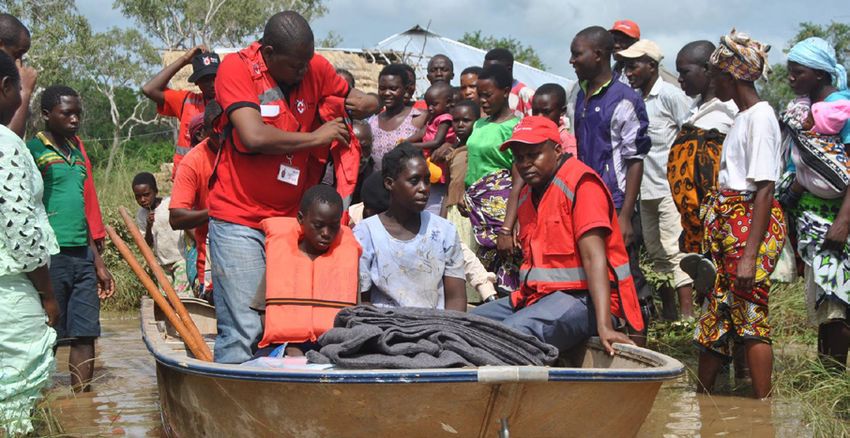
List of Figures
Figure 1: Components of an end to end early warning system.
Source: WMO, 2020 state of climate services report............................................. 6
Figure 2: Map of Tana River, Kilifi and Garissa counties located within
lower Athi and Tana sub-basins........................................................................... 8
Figure 3: Number of respondents interviewed in the three counties
across different decision making levels................................................................ 9
Figure 4: Occurrence of climate related hazards in Garissa, Kilifi
and Tana river counties........................................................................................ 10
Figure 5: Groups perceived to be vulnerable to floods across three counties ........ 11
Figure 6: Types of flood related early warning information that
are accessed across three counties at three decision making levels..................... 11
Figure 7: Sources of flood related early warning information across
three counties at three decision making levels..................................................... 12
Figure 8: Channels of flood early warning information communication
and dissemination across three counties at three decision making levels............. 13
Figure 9: Lead times for early warning information across three counties
at three decision making levels............................................................................ 13

List of Tables
Table 1: Gaps in the available flood EW information communication
across three counties at three decision making levels...........................................15

                            The Status of Flood Early Warning Communication in Lower Tana and Athi Basins            3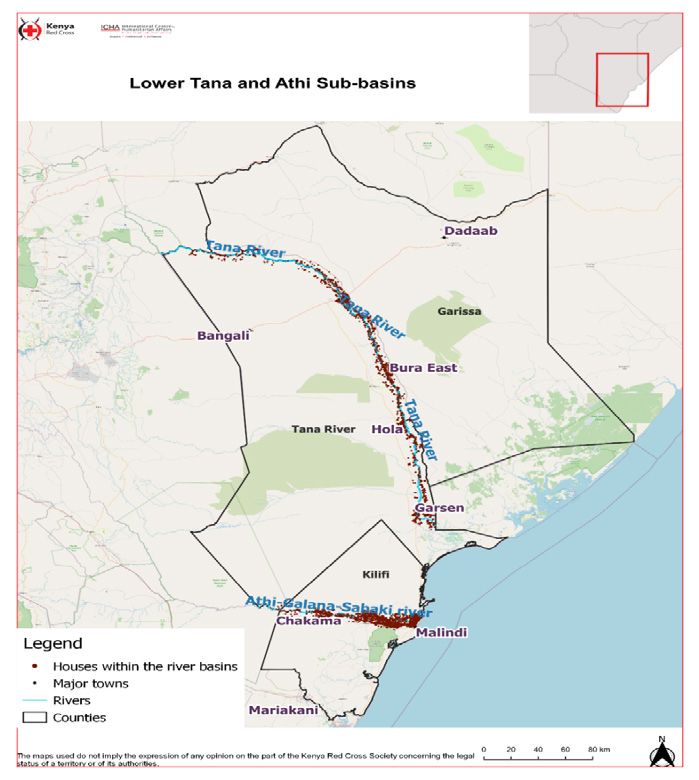
Occasional Paper Series No. 2

    Abstract
    Tana River, Kilifi and Garissa counties experience flooding due to persistent heavy rainfall in the Mt.
    Kenya and Aberdare ranges region. The flooding affects the socio-economic well-being of the communi-
    ties therein. Recently, there has been an increase in the frequency and intensity of heavy rains and vulner-
    ability of communities in these counties, exacerbating flooding impacts and this is expected to continue
    due to climate change. Although flood early warning information is produced by mandated institutions
    such as Kenya Meteorological Department and Water Resources Authority, a survey in the three counties
    shows that not all stakeholders are aware of the existence of flood early warning information. In some
    instances, stakeholders do not appreciate the information since it is not context specific. Further, the for-
    mat and language that the information is packaged in is not useful for the county stakeholders and the
    channels that are used for communication are not effective for all levels of decision making for example,
    community members would appreciate getting the information through radio and SMS. Additionally,
    some stakeholders lack the capacity to understand translate and integrate early warning information into
    decision making and sometimes the information is too late for them to take anticipatory action to mi-
    nimise the impact of floods. These challenges in communication of early warning information impede
    anticipatory disaster risk management efforts since without access to information actors cannot adequate-
    ly anticipate and prepare for disasters. This leads to disasters impacting government and communities
    and a response culture among humanitarian organisations. Hence the need to develop and enhance early
    warning communication systems through the development of context specific communication strategies
    that detail out; communication structures, timing and format for different actors. To foster ownership
    and trust among stakeholders and communities they should be involved in the development of the strat-
    egies and communication of early warning information. Constant engagement between producers of the
    information and users/stakeholders as well as sensitization foster trust amongst them and in the early
    warning information. The operationalization of communication systems is resource intensive and the
    counties need to invest in the process in order to ensure effective communication that can translate onto
    anticipatory action to reduce the impacts of floods.

4   Early Warning Communication for Enhanced Anticipatory Disaster Risk Management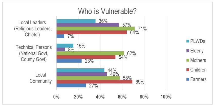
1.0 Background
1.1 Introduction
Globally, the last decade (2010-2019) has seen the proportion of weather and climate related disasters
inflate by 9% compared to the previous decade (2001-2010), and even higher by 14% with respect to the
1991 to 2000. A large portion (70%) of this increment was contributed by least developed countries, main-
ly from Africa. Further to this, disasters used to affect thousands of people during the period 1975-1985
however, from 2004 onwards this number has increased significantly to approximately 2 million people.
Equally, Kenya has recorded an increase in the number and frequency of weather and climate related
disasters. In particular, the Arid and Semi-Arid Lands which represent 80% of Kenya have witnessed and
increase in the frequency of floods due to the increased manifestation of systems that intensify rainfall in
most parts of Kenya such as the El Nino and the positive Indian Ocean Dipole.
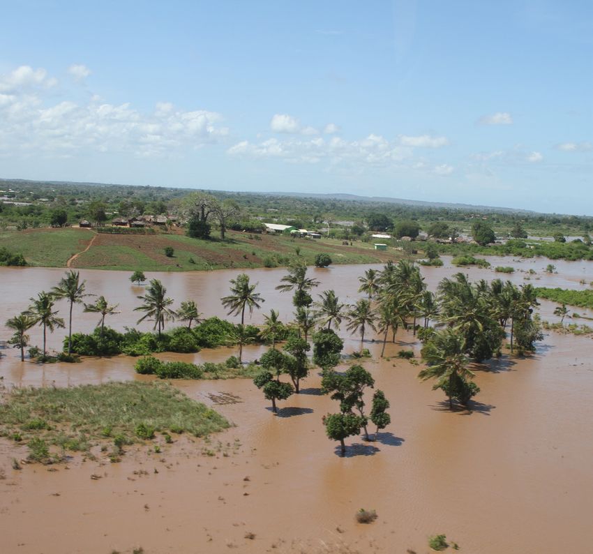
Within Kenya, floods occur due to; overflow of river banks and coastal areas when rainfall is enhanced
over a long period of time and sudden increase in overflow due to short lived heavy rainy events. How-
ever, floods can be aggravated by anthropogenic manipulation of watershed, drainage basins and flood
plains. In Tana River, Garissa and Kilifi counties floods are caused by the overflow of rivers Tana and
Athi when there is sustained heavy rainfall in Central and Southeast parts of Kenya. In some parts of
these counties normal rainfall can lead to floods due to the high intensity over a short period of time
leading to excess surface water runoff, the amount of runoff is higher in areas with high deforestation
and land degradation. The occurrence of floods in these three counties has always led to; disruption and/
or loss of livelihoods, displacement and massive migration of people, loss of lives, damage of property
and infrastructure and other cascading/secondary impacts such as outbreak of water and vector borne
diseases. Due to the high vulnerability of the communities in these counties, floods always lead to acute
human suffering and slow development as resources are always diverted to flood response.
As climate change increases the frequency and intensity of climate related hazards such as floods and
hence impacts on the most vulnerable, Early Warning Systems (EWS) are now being embraced as critical
components of disaster risk reduction (DRR) efforts. In fact, 138 out of 193 nations under the United
Nations Framework Convention on Climate Change (UNFCCC) have identified EWS as a top priority
through their Nationally Determined Contributions (NDCs). Additionally, target G of the Sendai Frame-
work for Disaster Risk Reduction 2015-2030 (UNFDRR) focuses on increased availability of and access to
a multi-hazard EWS. According to the World Meteorological Organisation (WMO), the components of
an end to end EWS (Figure 1) include; i) knowledge on disaster risk through continuous data collection
of onset and extent and magnitude ii) monitoring, analysis and forecasting what may happen and ex-
pected impact iii) dissemination and communication of forecasts, messages can also include what action
should be taken iv) preparedness and response based on warning received v) monitoring and evaluating
the social economic benefits of the EWS.
The Status of Flood Early Warning Communication in Lower Tana and Athi Basins 5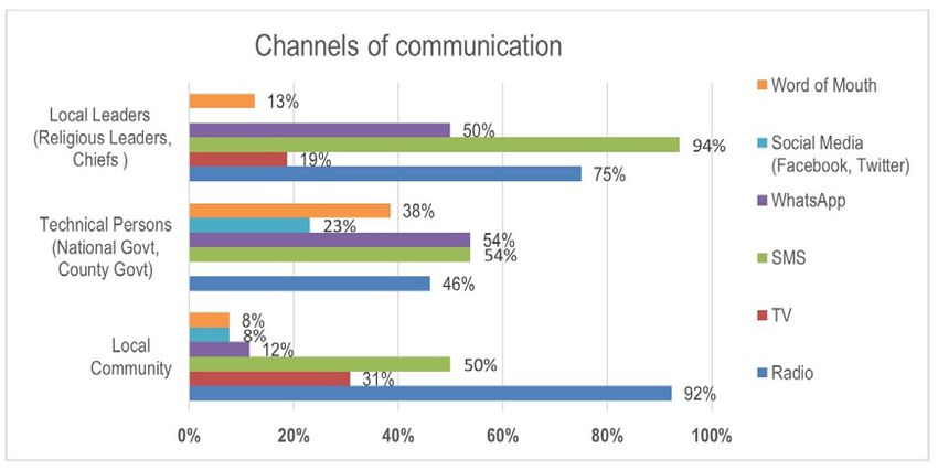
Occasional Paper Series No. 2

     Figure 1: Components of an end to end early warning system. Source: WMO, 2020 state of climate
                                             services report

    Recognizing the risk of flooding facing Garissa, Kilifi and Tana River counties and the lack of a system-
    atic flood EWS for the lower Tana and Athi basins, the StERC project (Box 1) has put in place an end
    to end EWS in these basins with the aim of enhancing preparedness and effective response which will in
    the end building resilience of vulnerable communities. While the project is implementing activities in
    all components of the EWS this paper will focus on the status of flood early warning communication in
    the three counties.
    Effective communication is a critical tool in the management of a disaster, as it provides institutions and
    communities with advance knowledge or warnings to take mitigating actions. According to Lindell and
    Perry (2004), for warning messages to be effective, they should have five essential components and these
    are; source, message, channel, receiver (audience) and feedback. That is, the source should be credible,
    the message clearly stated, a carefully selected channel for communicating the message, a clearly defined
    audience and a feedback channel for questions, comments and suggestions. In this context, this paper
    seeks to investigate the current status of flood early warning communication in the three counties taking
    stock of the challenges, gaps and opportunities with an aim of strengthening of flood risk management
    in these counties.

    Effective communication is a critical tool in the
    management of a disaster, as it provides institutions
    and communities with advance knowledge or
    warnings to take mitigating actions.

6   Early Warning Communication for Enhanced Anticipatory Disaster Risk Management
Box 1
The Kenya Red Cross Society (KRCS) and the British Red Cross (BRC) with funding from the European
Civil Protection and Humanitarian Aid Operations (ECHO) are implementing the Strengthening Early
Response Capacity (StERC) project in the Lower Tana and Athi basins with a focus on Garissa, Kilifi
and Tana River counties. The two-year project aims to improve the capacity of county government in-
stitutions, partners and communities to adequately prepare for and respond effectively to rapid onset
disasters in the counties. Ultimately, it will help mitigate the impact of rapid onset disasters to vulnerable
communities. Towards this, the project will address legislative, structural and system gaps on Disaster Risk
Management (DRM) at National-County-Ward level including: weak capacity and lack of coordination
among actors, ineffective Early Warning Early Action (EWEA) and transfer of Early Warning information
to the public. To achieve this, the StERC project objectives are:
a.  Strengthening an enabling environment (policy, legislation, structure and systems) of targeted county
    governments for effective disaster preparedness through advocacy and technical support
b. Improving systems for Early Warning Early Action in Lower Tana and Lower Athi sub-basins
c. KRCS responding to sudden onset emergencies or triggers of sudden onset emergencies effectively
    (Crisis modifier)
Major components of the project therefore are; i) technical and institutional capacity building program-
ming, empowering people including county government staff, disaster units/committees, communi-
ty-based response teams, volunteers and community groups for EWEA, and disaster preparedness and
response ii) people from high-risk areas will be covered by a functional EW system and reached through
information, communication and public awareness.

1.2 Area of study
The study area focuses on three counties within the lower Tana and lower Athi basin, these are; Garissa,
Tana River and Kilifi counties (Figure 2). The counties have a population of about 841,353 for Garissa,
315,943 for Tana River and 1,453,787 for Kilifi county1. Large populations are concentrated at townships
and closer to natural resources. For this reason, there exists pockets of higher population densities such
as Malindi (147 persons per square kilometer), Ijara (58 persons per square kilometer), Garissa Township
(49 persons per square kilometer), Galole (8 persons per square kilometer) according 2019 population
and housing census. Major economic activities in Garissa county include nomadic pastoralism, charcoal
production and crop farming. Main livelihood activities in the bordering Tana River county include crop
farming and pastoralism while tourism, fishing, crop and livestock farming dominate in Kilifi county.
The three counties are categorized under the Arid and Semi-Arid Lands (ASAL) regions whose annual
rainfall is between 300 – 600 mm. The less rainfall observed in ASALs results in; water scarcity, low agri-
cultural productivity, food insecurity, poor health outcomes and low socio-economic wellbeing2. With
most of the region in the three counties being arid, only very small sections that are close to Tana and
Athi rivers are left suitable for agriculture as a livelihood. This proximity to the rivers exposes commu-
nities to the risk of flooding whenever the rivers break their banks due to sustained heavy rainfall in the
upper catchment.

1    2019 Population and housing census report https://www.knbs.or.ke
2    The drought in Kenya, 2016–2017 < https://reliefweb.int/report/kenya/drought-kenya-2016-2017 >

                                 The Status of Flood Early Warning Communication in Lower Tana and Athi Basins   7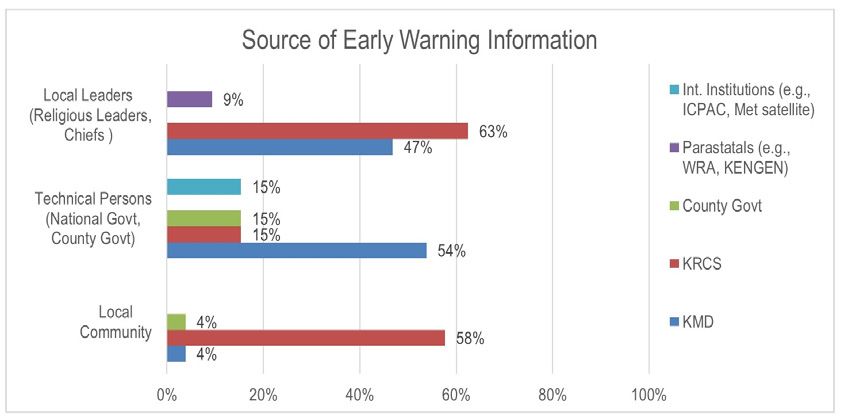
Occasional Paper Series No. 2

       Figure 2: Map of Tana River, Kilifi and Garissa counties located within lower Athi and Tana
                                                sub-basins.

    1.3 Objective and Methodology
    This paper draws on an activity that was implemented by the StERC project. The aim of the activity was
    to understand the status of flood early warning communication within the Garissa, Tana River and Kilifi
    counties which are adversely impacted by flooding and how this impacts of the flood risk management
    efforts. This entailed identification of; existing flood early warning communication systems and struc-
    tures; early warning information sources and types, targeted audiences and channels used to disseminate
    the information. This is key step towards strengthening flood early warning information dissemination
    and communication.
    To achieve this, a survey was conducted in 10 flood prone sub counties in the three counties. This rep-
    resents 67% of the sub-counties in three counties. The survey was through Key Informant Interviews (KIIs)
    with key flood management stakeholders in the counties and Focus Group Discussions (FDGs) with dif-
    ferent community groups. The KIIs were conducted in various institutions and departments in the county
    which include; department of special programme, department of disaster, department of communication,
    county director of meteorological services, water resources authority and chiefs/assistant chiefs. The FGDs
    in the at risk areas were conducted with groups such as women, men and youths. The number of respon-
    dents per county are represented in Figure 3 below, with Kilifi having the highest number.

8   Early Warning Communication for Enhanced Anticipatory Disaster Risk Management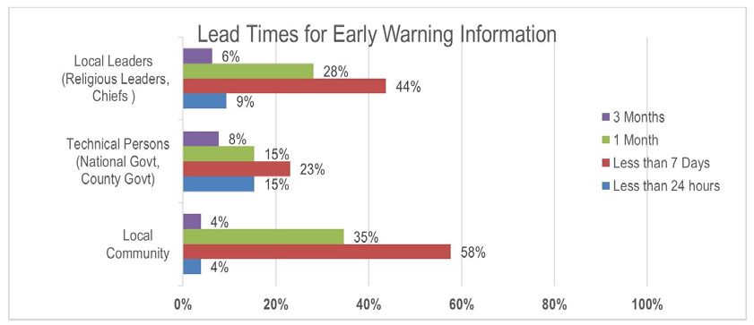
Figure 3: Number of respondents interviewed in the three counties across different decision making
                                             levels

                       The Status of Flood Early Warning Communication in Lower Tana and Athi Basins   9
Occasional Paper Series No. 2
2.0 Results
This section presents various types and sources of early warning information available in the three coun-
ties. Communication of this information is interrogated in line with channels that are deployed and lead
times of the information. Finally, gaps in flood early information communication are explored.
2.1 Trends and impacts of weather and climate hazards
Based on the data collected, 97% and 50% of the key informants interviewed recalled floods and drought
(Figure 4) respectively as the main hazards that have occurred in the counties for the past 30 years. This
concurs with WMO’s 2020 state of climate services report3, which indicates that countries around the
globe are experiencing an increase number of in flood events. In the three counties, records show that
flood events are increasing with years 1997, 2018, 2019 and 2020 having recorded floods. The 2018, 2019
and 2020 flood events were as a result of higher than average rainfall that was recorded in the upper
catchment; Mount Kenya and Aberdares areas. With climate change, such events are expected to increase
in frequency and severity.
Figure 4: Occurrence of climate related hazards in Garissa, Kilifi and Tana river counties.
Figure 5 shows the categories of people who the respondents perceived to be vulnerable to floods. General-
ly, all the respondents (local leaders, technical persons and community) were of the opinion that mothers
and children are the groups that are highly affected by floods. However, the community perceives that
children are affected more than women. The community and local leaders perceive that the elderly and
people living with disability rank third and fourth respectively and farmers rank last. Technical persons
perceive that farmers rank third and the elderly rank last. This disparity in ranking can be due to the fact
that, the community and local leaders are more aware of the flood impacts to people in the high risk areas
since they are also residents in these areas and have more local knowledge while technical people might
just be employees in these counties with limited local knowledge. Additionally, farmers might be per-
ceived to be less vulnerable since sometimes floods are associated with bumper harvests in the subsequent
seasons from rich alluvial deposits nevertheless, they also loose crops and livestock to washing by floods.
3 “2020 State of Climate Services” https://library.wmo.int/doc_num.php?explnum_id=10385
10 Early Warning Communication for Enhanced Anticipatory Disaster Risk ManagementFigure 5: Groups perceived to be vulnerable to floods across three counties
2.2 Types and sources of early warning information
Based on the survey, the types of early warning information that are received in the three counties that
can inform of flooding risk include; dam/river level monitoring, heavy rainfall forecasts, flood forecasts,
community flood vulnerability and advisories (Figure 6). In some instances, this information is interpret-
ed and shared out to the local communities through their local leaders such as chiefs, community health
volunteers and religious persons. From figure 6, technical respondents are more aware of the different
types of early warning information with the highest number being aware of heavy rainfall forecasts. Local
leaders are more aware of river level alerts; this is followed by heavy rainfall forecasts. The reason for
this disparity is that local leaders are part of a structure that monitors the river levels at strategic points
like Garissa bridge on a daily basis and relay this on a WhatsApp group so as to inform communities
downstream of possible flood risk. The communities seem less aware of existing early warning informa-
tion types and this underpins the need for a systematic communication system that ensures information
reaches the last mile users.
Figure 6: Types of flood related early warning information that are accessed across three counties at
three decision making levels
The Status of Flood Early Warning Communication in Lower Tana and Athi Basins 11Occasional Paper Series No. 2
Figure 7 shows the institutions that respondents perceive as sources of early warning information. There
is a big disparity in the sources listed by different groups of respondents. The local community recog-
nizes KRCS as a major source of early warning information while the county government and Kenya
Meteorological Department (KMD) are only recognized by a few community respondents. Local leaders
also recognized KRCS more with a significant number recognizing KMD. A large number of technical
persons recognize KMD as the main source of early warning information with only a few persons ac-
knowledging the county government, regional bodies such as IGAD Climate Prediction and Application
Center (ICPAC). Again, this disparity in sources of early warning information point to the need for har-
monization of access and communication of early warning information amongst different user groups.
Figure 7: Sources of flood related early warning information across three counties at three decision
making levels
2.3 Communication of Early Warning information
This section details the different channels being used to access and disseminate early warning informa-
tion as well as the frequency/lead time for dissemination of the different types of flood early warning
information.
2.3.1 Channels
Flood early warning information in the three counties is shared using different channels as shown in
Figure 8. Technical persons mostly receive the information via SMS and WhatsApp, a significant number
also receive the information via radio and word of mouth. The highest number of local leaders receive
the information via SMS, this is closely followed by radio and then WhatsApp. Among the local commu-
nity, most people receive information via radio and a significant number through SMS. This disparity in
channels that different stakeholders access the information through forms a good basis for disaggregating
effective channels of communication for different groups for example, in order to reach more community
members’, information should be disseminated via radio while SMS and WhatsApp can be used to reach
local leaders and technical persons respectively.
12 Early Warning Communication for Enhanced Anticipatory Disaster Risk ManagementFigure 8: Channels of flood early warning information communication and dissemination across
three counties at three decision making levels
2.3.2 Frequency / lead time
All respondents recognize that flood early warning information is available at different lead times4,
ranging from 3 months to less than 24 hours. Most respondents are aware of early warning informa-
tion that has lead times of a month and less than seven days. Interestingly, more respondents among
local leader and community are aware of these two lead times than the technical people. This could be
because more community members and local leaders receive alert SMS from KRCS as well as alerts on
river levels through the local early warning system while technical persons only receive the information
through official channels used institutionally. More technical persons are aware of the three month and
less than 24-hour lead times which is not the case among community members. These gap in awareness
of information at different lead times indicates there is still a gap in dissemination of information at the
different decision making levels.
Figure 9: Lead times for early warning information across three counties at three decision making
levels
4 Lead time is the time that is expected to elapse between the issuance of the forecast and the actual occurrence of the forecasted event
The Status of Flood Early Warning Communication in Lower Tana and Athi Basins 13Occasional Paper Series No. 2
2.4 Challenges and gaps in communication of early
warning information
More broadly, respondents in the three counties expressed the challenges faced in communication of
early warning (here onwards; EW) information (Table1). These challenges can be categorized into; lack
of policies and structures, limited access to EW information and inadequate capacity to interpret EW
information.
Technical persons indicated the need to enhance disaster policy and funding mechanisms to strengthen
disaster preparedness. Additionally, they specified the need to improve communication of EW informa-
tion by centralizing communication and enhancing structures. Further to communication, they stressed
on the need for capacity building of stakeholders on understanding, interpreting and using the EW infor-
mation. This is in recognition that stakeholders need to take preparedness action based on relevant and
contextualized information.
On the other hand, local leaders were looking at policy with a long term lens of dealing with flood and
were citing the need for sensitization of communities on flood risk management and need for collabo-
ration between stakeholders in implementing conservation measures as well as increasing infrastructure
upstream to conserve runoff water. In terms of EW information, they were advocating for; continuous
monitoring, timely access to information, and capacity building for stakeholders on access to and under-
standing, interpreting and using the EW information.
The local community perceive that the EW information should be credible and needs to be receive by
all especially those in flood prone areas. To enable implementation of preparedness action, information
should be timely and should be packaged in local languages. They advocate for use of channels such as
radio and SMS that are accessible to community members. Additionally, disaster committee members
should be trained on dissemination and understanding, interpreting and using the EW information. The
community also recognizes the need for development of infrastructure upstream to store run off.
In summary, respondents perceive that the current EW information is not timely and is not communi-
cated through effective channels and structures. Additionally, information should fit the stakeholders’
context and stakeholder capacity to be able to understand, interpret and use information. Respondents
also recognize they have a role in flood monitoring and need infrastructure developed to enable this.
Beyond communication, there are policy and infrastructural measures that need to be put in place to
manage flood risk.
14 Early Warning Communication for Enhanced Anticipatory Disaster Risk ManagementOccasional Paper Series No. 2
Table 1: Gaps in the available flood EW information communication across three counties at three decision making levels
Respondents Category Examples cited
Technical Per- Lack of policies and structures • Have a centralized EW communication system
sons at Nation- • Establishment of an emergency operation centers to collect, correlate and coordinate all flood information
al and County • Finalization of disaster management policies to strengthen early warning systems.
government • Set aside funding for disaster preparedness and contingency plans at county and national level
• Have guidelines for relocation in case of floods
Limited access to EW information • Improvement of the communication network; structures, channels, lead time, format
Inadequate technical capacity to inter- • The EW information provided must be relevant
pret EW information. • Messages should be specific for different decision makers
• Capacity building for stakeholders on understanding, interpreting and using the EW information
Limited community response capacity • Community sensitization on flood preparedness and effective response
Local Leaders Lack of policies and structures • Construction of additional dams for agriculture
• Collaboration amongst stakeholders on ecosystem restoration e.g. planting bamboos trees along rivers
• Practicing soil and water conservation measure such as building gabions
• Development of well-structured communication strategies for floods
• Permanent relocation to higher grounds
Limited access to EW information • Continuous monitoring of flood related information by stakeholders
• Improvement of communication network and structures; different committees should get the information at different times
• Need to establish gauge stations so that to monitor the river water levels and the communities trained on how to use the equipment
Inadequate technical capacity to inter- • Capacity building for stakeholders on access to and understanding, interpreting and using the EW information
pret EW information. • Setting up local station where can easily get updates
• Timely dissemination of EW information to inform preparedness
Limited community response capacity • Regular sensitization of community members on flood preparedness, response and recovery measures
• The community should be sensitized on taking action based on EW information
Local commu- Lack of policies and structures • Setting up a dams upstream to reserve the runoff
nity
Limited access to EW information • EW information should be effective and should reach everyone who is in flood risk areas
• Timely dissemination of EW to alert people, preferably through SMS or radio
• Improvement of communication network for easy access to EW information
• EW information should be in local languages
Inadequate technical capacity to inter- • Training for disaster committee members on dissemination and understanding, interpreting and using the EW information
pret EW information. • EW information received must be accurate
Limited community response capacity • Need to ensure credibility of the floods early warning information source
The Status of Flood Early Warning Communication in Lower Tana and Athi Basins 15Occasional Paper Series No. 2
3.0 Discussion
Dissemination and communication of early warning information is being recognized as a key pillar in
disaster risk management. To enhance communication of early warning information; communication
structures, timing, channels, format and language of message should be enhanced and made context spe-
cific. Despite the generation and communication of forecast information that inform on flooding by the
Kenya Meteorological Department (KMD) at national and county level for different lead times (seasonal,
monthly, weekly, daily and heavy rainfall forecasts) this information does not reach all and when it does,
it is not systematically used for flood preparedness and response.
Findings from the survey conducted in Kilifi, Garissa, and Tana River counties revealed that in the
three counties, there exist flood early warning information primarily generated and shared by the Kenya
Meteorological Department and Water Resources Authority. The information is disseminated directly
to key county stakeholders and also through intermediaries including local leaders. Some of the inter-
mediaries include institutions like KRCS, NDMA and KENGEN which play a significant role in inter-
preting the forecasts information and sharing tailor-made flood early warning information with vulner-
able communities in flood prone regions/locations. The dissemination and communication of different
types of early warning information is done through various channels of communication such as SMS,
WhatsApp and Radio.
The results have also shown that the forecast information is packaged using technical language and hence,
hindering the capacity of the communities to understand and translate the information into action.
This hinders the ability of communities and governments to anticipate and prepare for disasters hence
government and communities are always negatively impacted by disasters and humanitarian organisa-
tions end up having a response culture. With accessible timely and concise early warning information,
communities, governments and organisation would be able to anticipate and prepare for disasters hence
reducing the impacts of disasters on the vulnerable. This is a clear evidence for the need to strengthen the
dissemination and communication of flood early warning information with the lower Tana and lower
Athi sub-basins. Towards addressing these gaps, the StERC project focused on enhancing the commu-
nication of flood early warning information in the three counties through the development of county
specific early warning communication strategies using the survey findings. The strategies provide clear
frameworks towards ensuring that early warning information reaches the last mile users. The communi-
cation strategies focus on; advocating for improvement of the accuracy of warnings, enhancing commu-
nication and dissemination of early warning information, embracing new techniques to alert the public,
ensuring early warning information targeted the right people and ensuring that the warning messages are
well understood by users. This will be achieved once the communication strategies are operationalized by
the respective counties.
With accessible timely and concise early warning
information, communities, governments and
organisation would be able to anticipate and
prepare for disasters hence reducing the impacts
of disasters on the vulnerable.
16 Early Warning Communication for Enhanced Anticipatory Disaster Risk Management4.0 Conclusions
As the occurrence of climate related disasters such as floods continues to increase, it is evident that human
lives, properties as well as livelihoods are threatened. The three counties are and will continue experiencing
impacts from the increasing extreme climate events such as heavy rainfall that result in flooding. To this
end, it’s crucial to disseminate and communicate timely and credible early warning information to enable
communities and institutions to anticipate and prepare for disasters by implementing anticipatory action
before they occur. In the Kenyan context, with devolution, disaster risk management is a shared function
between the county government and national government. This affirms the importance of having county
led disaster preparedness plans as well as county specific communication strategies to streamline the flow
of early warning information within respective counties.
Recognizing, the need for anticipatory action from the community level where disaster impacts are felt
greatly, the dissemination of flood early warning information in the counties ought to have structures in
place to promptly relay the information to the vulnerable communities. In an effort, to enhance prepared-
ness and early response capacity within the three counties, the StERC project supported the development
of flood early warning strategies in the three counties however, disaster communication strategies should
be developed in all counties to ensure communities and governments can adequately anticipate and pre-
pare for disasters so as to mitigate their impacts and protect lives and livelihoods.
...Disaster communication strategies should be
developed in all counties to ensure communities
and governments can adequately anticipate
and prepare for disasters so as to mitigate their
impacts and protect lives and livelihoods.
The Status of Flood Early Warning Communication in Lower Tana and Athi Basins 17Occasional Paper Series No. 2
5.0 Recommendations
To improve the efficiency of flood early warning information and communication in the three counties,
we make the following recommendations;
1. Tana River, Garissa and Kilifi counties through key departments such as disaster and communi-
cation departments should operationalize county specific flood early warning communication
strategies to ensure EW information reaches the last mile users.
2. To enhance understanding of early warning information being disseminated at community level,
there is need for the mandated institutions like KMD to embrace stakeholder’s engagement and
co-production of actionable EW information as well as enhance capacity building on interpreta-
tion and use of the information.
3. There is need to invest resources towards systematic communication of early warning informa-
tion.
4. The community should be involved in monitoring and communication of flood EW informa-
tion. This will create ownership and trust in the EW warning information.
5. To encourage the systematic use of EW information for disaster risk management especially in
preparedness, there should be capacity building for stakeholders on interpretation and use of the
information as well as regular awareness creation and sensitization among stakeholders
South “C” (Bellevue) Red Cross Road, Off Popo Road
P.O Box 40712, 00100 - GPO, Nairobi, Kenya
Tel: (254-20) 3950000/ 2355062/3 Fax: (254-20) 3950444
Mobiles: 0722-206958, 0703037000, 0733-333045
Email: info@icha.net, Website: www.icha.net
18 Early Warning Communication for Enhanced Anticipatory Disaster Risk Management
© 2021You can also read