Bar Harbor Project Center Trail View: Acadia National Park
←
→
Page content transcription
If your browser does not render page correctly, please read the page content below
Bar Harbor Project Center
Trail View: Acadia National Park

              An Interactive Qualifying Project
                  Submitted to the Faculty of
               Worcester Polytechnic Institute
      in partial fulfillment of the requirements for the
               Degree of Bachelor of Science

                    Student Authors:
                      Emily Anness
                      William Korb
                   Lauren A. Mickelson
                       Quinn Perry

                     Project Advisor:
                Professor Frederick Bianchi

                       July 26, 2012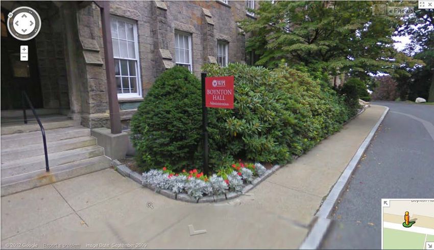
Acknowledgments
Professor Frederick Bianchi, for his guidance throughout the course of the project, and for

loaning us equipment.

Dean Karen Oats, Rick Vaz, and Thea, for their feedback on the progress of our project.

Nathan Roux, for editing photos and videos for our presentation.

Dominic Lopriore, for editing glitches out of some panoramic photos.

Nigel, for getting us through hardships.

                                                                                          2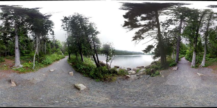
Table of Contents
An Interactive Qualifying Project ....................................................................................................1
Student Authors: ............................................................................................................................1
Project Advisor: .............................................................................................................................1
Acknowledgments............................................................................................................................2
Table of Contents .............................................................................................................................3
Table of Figures ...............................................................................................................................5
Abstract ............................................................................................................................................6
Executive Summary .........................................................................................................................7
1.0 Introduction ..............................................................................................................................10
2.0 Background ..............................................................................................................................12
  2.1 Mount Desert Island History ................................................................................................12
  2.2 Trail History .........................................................................................................................14
  2.3 Surveying History ................................................................................................................16
  2.4 Information Distribution ......................................................................................................19
  2.5 Similar Projects ....................................................................................................................20
     2.5.1 Acadia National Park .....................................................................................................20
     2.5.2 Nature Valley Trail View ...............................................................................................22
     2.5.3 Google Earth Outreach ..................................................................................................22
     2.5.4 Google Street View ........................................................................................................23
  2.6 Information Collection .........................................................................................................24
     2.6.1 Panoramic Photos ..........................................................................................................24
     2.6.2 Audio .............................................................................................................................24
     2.6.3 Atmospherics .................................................................................................................25
     2.6.4 Flora ...............................................................................................................................25
     2.6.5 Fauna .............................................................................................................................29
3.0 Methodology ............................................................................................................................33
  3.1 Choosing a Trail ...................................................................................................................33
     3.1.1 Initial assessment ...........................................................................................................33
     3.1.2 Documented Trails .........................................................................................................34
  3.2 Camera Selection..................................................................................................................35
  3.3 Compiling Trail Data into Product .......................................................................................35
  3.4 Application Programming Interface .....................................................................................36
4.0 Results and Analysis ................................................................................................................37
  4.1 Choosing a Trail ...................................................................................................................37
  4.2 API........................................................................................................................................38
     4.2.1 Automation ....................................................................................................................40
  4.3 Technical Issues ....................................................................................................................41
     4.3.1 Camera Selection ...........................................................................................................41
     4.3.2 Tripod vs. Monopod ......................................................................................................43
     4.3.3 Spacing between Data Points ........................................................................................43
  4.4 Website .................................................................................................................................44
5.0 Recommendations ....................................................................................................................46

                                                                                                                                                    3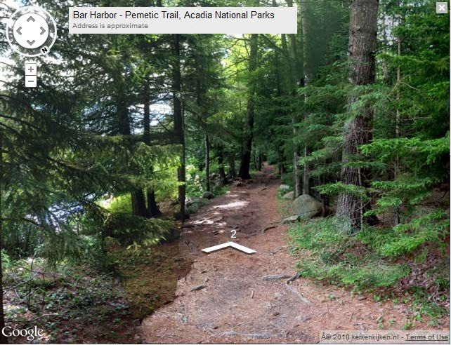
5.1 Data Collection.....................................................................................................................46
    5.1.1 Camera Selection ...........................................................................................................46
  5.2 Data Presentation..................................................................................................................47
    5.2.1 Additional Website Components ...................................................................................47
    5.2.2 Crowdsourcing...............................................................................................................48
  5.3 Trail View in the Community ...............................................................................................50
    5.3.1 Technology and Education ............................................................................................50
    5.3.2 Technology and Health ..................................................................................................51
  5.4 Collaborations and Funding .................................................................................................51
6.0 Conclusions ..............................................................................................................................54
Bibliography ..................................................................................................................................56
Appendix I: Flora ...........................................................................................................................58
Appendix II: Fauna ........................................................................................................................62
Appendix III: Acadia National Park Trails ....................................................................................69

                                                                                                                                               4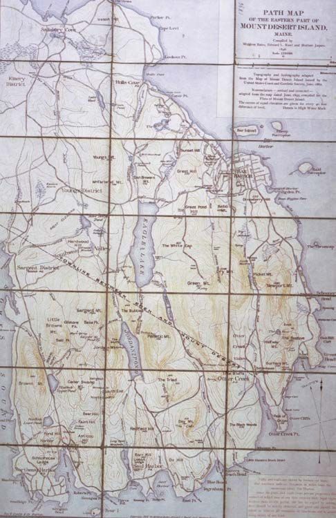
Table of Figures
Figure 1: Tilted Rock, circa 1900 (left) and 1928 (right). .............................................................11
Figure 2: Map of Mount Desert Island ......................................................................................... 13
Figure 3: First Path Map of Eastern Part of Mount Desert Island (1896)..................................... 15
Figure 4: Maps of Mount Desert Island Trails, 1830 (left), 1870 (center), 1890 (right). ............. 17
Figure 5: Mount Desert Island Trails with Elevation.................................................................... 17
Figure 6: Modern Theodolite7 ....................................................................................................... 18
Figure 7: 1820 Repeating Theodolite6 .......................................................................................... 18
Figure 8: The First Mount Desert Island Travel Guide................................................................. 19
Figure 9: Google Street View Screenshot of Boynton Hall at WPI .............................................. 23
Figure 10: Panorama created by Microsoft Photosynth on the iPhone ......................................... 24
Figure 11: Oyster mushroom ........................................................................................................ 25
Figure 12: Tree clubmoss .............................................................................................................. 26
Figure 13: Sensitive Fern .............................................................................................................. 26
Figure 14: Identifying a Tree-Crown Shape ................................................................................. 27
Figure 15: Identifying Tree-Leaf Shapes and Leaf Arrangements................................................ 28
Figure 16: Parts of a Flower.......................................................................................................... 28
Figure 17: Twelve Spotted Skimmer ............................................................................................ 29
Figure 18: Question mark ............................................................................................................. 30
Figure 19: True katydid................................................................................................................. 30
Figure 20: Common loon .............................................................................................................. 30
Figure 21: Hooded merganser ....................................................................................................... 31
Figure 22: Northern Flicker .......................................................................................................... 31
Figure 23: Great Head Trail Coastline View................................................................................. 34
Figure 24: The Nikon D70 ............................................................................................................ 41
Figure 25: The iPhone ................................................................................................................... 42
Figure 26: Trail View map feature ................................................................................................ 42
Figure 27: Trail View website screenshot ..................................................................................... 45

                                                                                                                                          5
Abstract
Environmental awareness has become a worldwide subject. Recent technological advancements

have allowed for viewing various aspects of our world from different perspectives. The objective

of the Trail View project was to create an interactive website that documents in-depth visual,

auditory, and physical information pertaining to Acadia National Park. The website presents a

map feature similar to that of Google Street View, containing panoramas of Acadia’s hiking

trails. The attributes benefit outdoor enthusiasts and promote education, public awareness, and

respect for the environment.

                                                                                              6
Executive Summary
         As advancements in technology are made, information becomes more readily available to

the public. Although the experience is limited, people can encounter various aspects of the world

in a relatively short amount of time. Despite this, consumers may become immersed in other

artificial environments that technology can create. Our goal is to link people back to the national

parks.

         Trail View is an interactive website that conservationists and outdoor enthusiasts can use

to enhance their hiking experience in Acadia National Park. The objective of Trail View is to

document hiking trails using modern technology. This website’s archives of atmospheric,

auditory, and visual information set it apart from similar projects. It will be capable of aiding

outdoor recreationalists if they wish to obtain more information about the conditions of an

Acadia National Park trail.

         The user will be able to explore a trail from the comfort of the user’s browser, as the

program works similar to that of Google Maps’ Street View. With the proposed Trail View map,

hikers would be able to see the trail they are going to travel before deciding if they want to trek

it. In this way, they can note potential preparations for their hike, such as conditioning

themselves physically and mentally, or by packing the appropriate gear. Being informed in this

manner provides for a more involved and a more interactive experience with the trails.

         In order to complete the project, the team collected data while hiking a trail. Upon arrival,

the team took its first panoramic photo so as to include a picture of the head of the trail. At this

point, wind speed and temperature data were collected and recorded. This process was to be

                                                                                                    7
repeated each time the trail curved. Intermittently, the group took audio recordings and still

photos, logging their location.

       Originally, the team intended on using only the map feature as the final product of this

project. Due to bandwidth constraints and budgeting, the full website could not be hosted on

viewyourtrail.com. Trail View was built locally and contained information in addition to the map

feature. Designed for user-friendliness and accessibility, Trail View features interactive menus

which contain pop-up links to the still photos of flora and fauna, audio clips, and atmospheric

data such as temperature and wind speed. The final product was a compilation of all data samples

on the Trail View website.

       An Application Programming Interface (API) is a software program that acts as an

interface so as to allow two software components to communicate. The Google Street View API,

was one of the major building blocks of the Trail View software. This API allowed for the

panoramic imaging technology available in Google Street View to be harnessed for other

purposes; in this case, to document trail images for the map function. The Google API accepts

panoramic images and puts them together to simulate a three-dimensional (3D) image, able to be

browsed by a user.

       In order to create the map function and simulate a trail using the Google API, one had to

specify the order of the panoramic photos, and then upload them to the website. To customize

Trail View, the group made edits to the Google API by utilizing Javascript. Changing font sizes

and inserting custom overlays are examples of some of the edits made to the API.

       The ultimate goal of this project was to create a proof of concept for expansion of Trail

View. By the end of the project, the team had completed the photographic documentation of the

Great Head Trail and had done a portion of both the Jordan Pond Path and the Pemetic Northeast

                                                                                              8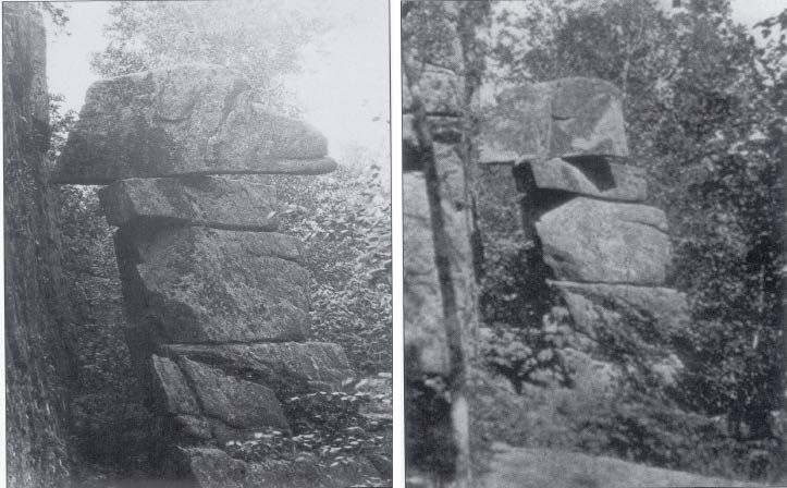
Face Trail. The portions of the Jordon Pond Path and the Pemetic Northeast Face Trail that were

completed worked as practice of the methodology.

       Trail View is a website that documents Acadia National Park’s hiking trails using modern

technology. The website features still photos, audio clips, wind speed and temperature data, and a

map feature of the trails. The equipment the group used included an iPhone, an anemometer, a

Tascam audio recorder, and a Nikon D70 camera. The collected data was then compiled on the

website, viewyourtrail.com. To further this project, future groups should seek funding or

collaboration. However, the team feels that as a proof of concept, the project was very

successful.

                                                                                                9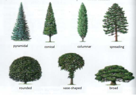
1.0 Introduction
          The purpose of Trail View is to document hiking trails using 21st century technology.

Trail View is an interactive website that conservationists and outdoor recreationalists can use to

enhance their hiking experience in Acadia National Park. This website is an archive of relevant

hiking data including atmospheric, auditory, and visual information. It will be capable of aiding

outdoor recreationalists if they wish to obtain more information about the conditions of an

Acadia National Park trail. Potentially, this technology will indirectly keep track of

environmental changes, migratory patterns of some wildlife, and the presence of flora and fauna.

          The user will be able to explore a trail from the comfort of his or her browser, as the

program works similar to that of Google Maps’ Street View. Street View allows a user to virtually

tour a roadway by toggling the point of view on panoramas pieced together. With the proposed

Trail View map, hikers would be able to see the trail they are going to travel before trekking it. In

this way, they can know how to prepare for their hike, whether by conditioning themselves

physically and mentally, or by packing the appropriate gear. Being informed in this manner

provides for a more involved and a more interactive experience with the trails.

          In addition to the practical purposes, Trail View is important for documentation. For

example, in 1947, an immense fire devastated a significant area of Mount Desert Island,

destroying the majority of Acadia National Park. Without proper documentation, the topography

of the trails prior to the fire would be lost. An example in which there was proper documentation

is “Tilting Rock,” 1 a rock formation near Seal Harbor on the southeast side of Day Mountain.

1
    Pathmakers

                                                                                                  10
The Tilting Rock was toppled by vandals in 1922 and later reset by the Seal Harbor Village
Improvement Society.
Figure 1: Tilted Rock, circa 1900 (left) and 1928 (right).
Trail View is a website which uses a modern method of documenting Acadia National
Park’s hiking trails. The website provides visual, atmospheric, and auditory records of the trails
for practical and archival purposes. It utilizes a series of panoramic images to present this
information in an interactive form. Trail View will be useful for outdoor recreationalists and
conservationists.
112.0 Background
2.1 Mount Desert Island History
Mount Desert Island is the largest island off the coast of Maine. Located in Hancock
County, the island consists of four towns; Mount Desert, Southwest Harbor, Tremont, and Bar
Harbor; each with multiple villages within the town. The lakes, mountaintops, and overall shape
of the island were formed by a continental glacier about 25,000 years ago. The Wabanaki people
who were native to the island referred to their land as ‘Pemetic’, meaning sloping land. On
September 5, 1604, French explorer Samuel de Champlain landed on the island. He dubbed it
‘Isles des Monts Désert,’ French for island of the bare mountains.
Bar Harbor is a busy tourist town on Mount Desert Island in the summer. The Wabanaki
people called Bar Harbor ‘Manesayd’ik’, or clam-gathering place. It was settled in 1763 and was
incorporated on February 23, 1796 as Eden. Because of its proximity to Acadia National Park,
Bar Harbor attracts summer tourists. With several hotels, shops, inns, taverns, and restaurants, it
is usually the place visitors come to on Mount Desert Island.
12Figure 2: Map of Mount Desert Island
George B. Dorr (1855-1944) is known as the father of Acadia National Park. He was a
wealthy citizen who lived in Bar Harbor and later felt that the land needed to be preserved. On
September 12, 1901, he became one of the founders of the Hancock County Trustees of Public
Reservations. This committee was incorporated for the purpose of “acquiring, owning, and
holding lands and other property in Hancock County for free public use.” 2
2
Acadia National Park, Hancock County Trustees of Public Reservations
13On July 8, 1916, the park was established under its first name, Sieur de Monts National
Monument, with Dorr as the monument’s first superintendent. The name was changed on
February 26, 1919 to Lafayette National Park. It retained that name for almost a decade until
January 19, 1929, when the park was given its current name of Acadia National Park. From 1915
to 1933 John D. Rockefeller, Jr. donated over 11,000 acres of land to the park and had carriage
trails built throughout it.
The current 47,000 acres of Acadia National Park consist of several types of terrain. This
includes woodlands, lakes, ocean shoreline, and mountains. Cadillac Mountain, named after the
French explorer Antoine Laumet de La Mothe, sieur de Cadillac, is the tallest mountain on the
U.S. East Coast and the first place in the United States to see the sunrise 3. The park is also home
to Somes Sound, the only fjord on the East Coast. A fjord consists of a long, narrow bay
surrounded by steep cliffs formed by glacial erosion. Mount Desert Island has an eclectic
assortment of topography and a distinguished history, which makes it a unique and intriguing
area.
2.2 Trail History
Many of the trails in Acadia National Park were once used for travel by the native peoples
and European settlers, until modern roads became the island’s central routes for transportation.
Before these modern roads were built, the trails were not only used for everyday transportation,
but also for recreational purposes, such as enjoying the landscape. These mid-1800s
recreationalists were settlers who owned summer cottages in Acadia.
3
TripAdvisor, Acadia National Park: Cadillac Mountain
14In 1891, the Road and Paths
Committee of the Bar Harbor Village
Improvement Association (VIA) was
initiated and began drafting plans for new
trails 4. People would donate the funds
required to build a new trail, and in return
they could name the trail in honor of anyone
they wanted. On many occasions, there were
plaques placed along the trails in memory of
the honoree. This system proved to be a
catalyst in the creation of new hiking paths.
Waldron Bates was the chairman of the
Road and Paths Committee of the Bar
Harbor VIA from 1900 until 1909. His
Figure 3: First Path Map of Eastern Part of Mount
Desert Island (1896)
pioneering work on the park’s trail
construction included incorporating stone stairways and iron-rung ladders to traverse steep areas.
He also wrote the first trail handbook for the actual constructors of the trails and was the lead
author of the first island hiking path map. At the head of the Cadillac Cliffs Trails and the
Gorham Mountain Trail is a plaque, honoring him as the ‘Pathmaker’. As a result of the Road
and Path Committee’s work, there were more than 200 miles of trails on Mount Desert Island by
1915.
4
A Guide’s Guide To Acadia National Park
15After the Great Depression, the Civilian Conservation Corps (CCC) was introduced to
Acadia National Park. The CCC was a public relief program that operated from 1933 to 1942 as
a result of Franklin D. Roosevelt’s New Deal. The New Deal made manual labor jobs related to
conservation of natural resources available to unemployed men of a certain age. The CCC set up
two sites of operation on the island. Their work on the trails was extensive, demonstrated by the
addition of new trails and the renovation of older trails.
2.3 Surveying History
Mount Desert Island was first documented by a series of visitors, referred to as
“rusticators” 5. These rusticators consisted of artists, surveyors, and tourists. One famous
surveyor was Charles Thomas Jackson, who mapped the mountains of Maine from 1836 to
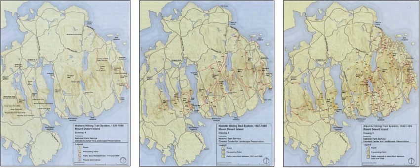
1838 6. Figure 4 shows a progression of trail maps on Mount Desert Island from 1830 to 1890.
Figure 5 shows a map of contour elevations on Mount Desert Island.
5
Brown, et al, Pathmakers.
6
Pathmakers
16Figure 4: Maps of Mount Desert Island Trails, 1830 (left), 1870 (center), 1890 (right).
The first method of geodetic survey was through
triangulation, a method of measurement that calculates an
unknown distance using the geometry of a triangle.
However, this method was proven to be flawed. In 1718,
Jean Picard and the Cassini family finished their research
using triangulation to determine the Earth’s shape. They
concluded that the Earth is a prolate ellipsoid, which
conflicted with Newton’s 1687 theory that the Earth was
oblate. In 1733, the length of the meridian was measured Figure 5: Mount Desert Island Trails
with Elevation
across both France and the Lapland. The expedition found
that one degree of the meridian is shorter at the equator than in France, thus proving that Newton
was correct that the Earth is oblate 7.
7
NOAA, 2006
17A theodolite is an instrument used for measuring angles in horizontal and vertical planes.
In 1790, the French invented the repeating theodolite 8. Because the repeating theodolite had
many moveable parts and mechanical motions, there were many sources of error. Modern
theodolites are more efficient and precise. Today, theodolites are primarily used for surveying,
but have recently been modified for metrology and rocket launch technology.
Figure 7: 1820 Repeating Theodolite6 Figure 6: Modern Theodolite7
In 1937 the first electronic digital computing device was constructed: the Atanasoff-Berry
Computer. This creation introduced a new era for surveying. By 1953 the first electronic distance
measuring instrument, the Model 1 Geodimeter, was invented. Its successor, the Model 2
Geodimeter, was created in 1956. Surveyors worked to fashion a lightweight model that worked
with different mediums of measurement reading technology, such as lasers and microwaves 9. By
1993 the Global Positioning System (GPS) was invented. The GPS uses a network of satellites
and a receiver to determine latitude, longitude, and altitude 10.
8
NOAA, 2006
9
NOAA
10
National Park Service, Global Positioning Systems
182.4 Information Distribution
In order to promote business, railroad and steamship companies printed advertisements of
Mount Desert Island in the late 1860s and the 1870s. As the number of visitors began to grow,
writers published travel guides that portrayed
the natural scenery, the first of which was
written by Clara Barnes Martin in 1867 11. Some
of the trails that were described in the guides
were more developed than others, and the trails
that saw a lot of visitors began to develop on
their own. These travel guides provided the first
source for visitors to find information about
Mount Desert Island.
Since their incorporation in 1890, the
Bar Harbor VIA have been publishing annual
reports, documenting all the work they did in
Bar Harbor, including the construction of new Figure 8: The First Mount Desert Island Travel Guide
trails. As the park grew, the new travel guides began to incorporate information about the various
resources available to the visitors. In the early 1900s, travel guides and brochures were the main
source of information about Acadia National Park.
11
Pathmakers
19Today, Acadia National Park uses media such as the National Park Service website
(http://www.nps.gov/acad/index.htm) to provide information about the park. The variety of
topics covered on the website is vast, with information such as directions to Acadia National
Park, GPS coordinates of various locations, current park alerts, maps, the park history, the
animals found there, park news, and more. Also available on the website are the current
brochures that the park uses. These brochures can be downloaded directly to one’s computer. In
addition to these brochures is the Guide’s Guide to Acadia National Park. Besides the back-end
personnel this guide is intended for, the public has access to this surplus of information
concerning Acadia National Park.
2.5 Similar Projects
2.5.1 Acadia National Park
Acadia National Park uses online resources to distribute information about the park. On
its website, one can access visual data under the ‘Photos and Multimedia’ section, which
constitutes a photo gallery, webcam, virtual tour, and multimedia presentations. The Internet is
one of the Park’s primary tools to provide as much information to visitors as possible. One can
experience aspects of the park from the comfort of one’s home.
The webcam component of the Photos & Multimedia section links to CAMNET. The
page on CAMNET gives the user “Realtime Air Pollution & Visibility Monitoring” 12 and
updates the web page every fifteen minutes with a picture of Frenchman Bay accompanied by
various atmospheric data. This includes temperature, humidity, wind speed, wind direction, and
12
CAMNET
20precipitation. In addition to these meteorological conditions, there is data on air pollution. This is
comprised of levels of ozone and fine particles in the air. With this data, one can determine if the
level of visibility in the photo is attributed to pollution or natural causes. For example, if the
visibility is low, but the fine particles and the ozone levels are high, then the level of visibility is
attributed to pollution.
One example of a virtual tour and of visual and auditory data on the Acadia National Park
website is eCruise. The Acadia National Park eCruise is a virtual journey of the waters around
Mount Desert Island, accompanied by: informative text; still photos and panoramic images;
videos of park rangers presenting information and history; time lapsed videos of tides; audio
samples of the ocean; and both audio and video samples of wildlife.
In the Photos and Multimedia section, there is an extensive photo gallery. There are
photos of earthquake effects, the founders of Acadia National Park, the changing of the seasons,
Baker Island, and more. In addition to these galleries, there is a section titled PanoramAcadia,
which contains panoramic images of Mount Desert Island. The images are along various
coastlines of Mount Desert Island. One is on top of Dorr Mountain, which is the third tallest
mountain on the island.
The Multimedia Presentations section contains audio and video presentations that share
various aspects of the park. There is a collection of one-minute audio and video clips of nature
called ‘The Acadia National Park Minute Out In It’. These clips include video and audio samples
of wildlife. The ‘Ranger Minutes’ are short audiocasts and videocasts in which park rangers offer
information about the park’s history and resources. In addition to these presentations is a section
titled ‘More Movies’. This is a group of films that demonstrate the events and programs that take
place in Acadia National Park.
212.5.2 Nature Valley Trail View
Nature Valley Trail View (http://www.naturevalleytrailview.com) allows users to view
several national park trails in Yellowstone National Park, the Grand Canyon, and the Great
Smokey Mountains. One can travel along the trails just as one can travel along Google Maps
Street View. In addition to the trails, Nature Valley highlights several ‘Points of Interest,’ the
length of the trail, the difficulty of the trail, and the elevation along the trail. The Yellowstone
National Park features twenty-seven trails, the Grand Canyon features eleven trails, and the
Great Smokey Mountains features eighteen trails. The Nature Valley Trail View website also has
a biography section on the people who worked to create the project, along with other sections on
how it was made.
2.5.3 Google Earth Outreach
Google Earth Outreach is an organization that seeks to aid nonprofit and public benefit
organizations. They do this through providing education, resources, and grants so that nonprofit
and public benefit organizations can utilize Google Earth and Maps for their purposes. There are
extensive educational opportunities available to the organizations by way of video tutorials,
conferences, and workshops, all of which can be found on the Google Earth Outreach website
(http://www.google.com/earth/outreach/index.html).
There are two different kinds of grants that organizations can apply for. One is a software
grant, in which Google Earth Outreach provides some of their mapping technologies. This gives
the organizations advanced products to work with, such as Google Earth Pro, Google SketchUp
Pro, and Google Maps API for Business. The other grant is a developer grant. This provides the
user with the developers necessary to make their vision of the Google Earth and Maps
application come to fruition. The developers can solve issues the organizations may be struggling
22with, or enhance what they already have. The website also has success stories of organizations
utilizing Google Earth and Maps for their purposes. These case studies can be viewed on the
website, each accompanied with examples of the software developed, a video about the project,
and a written summary of the project.
2.5.4 Google Street View
Released May 25, 2007, Google Street View is a technology in Google Earth and Google
Maps which provides 360° panoramic views of many streets of the world. In Street View, the
user can zoom in and out, rotate the picture in all directions, and move to the next panorama. In
order to create the panoramic images, Google uses the Street View Car. Mounted on the roof of
the car is a fifteen-lens camera that takes 360 degrees of pictures. The images taken by this
camera are stitched and used for Google Street View.
Figure 9: Google Street View Screenshot of Boynton Hall at WPI
232.6 Information Collection
2.6.1 Panoramic Photos
Panoramic photography is a technique in which images are captured with elongated fields
of view. It is not known when the idea of panoramic photography first emerged, but it is widely
believed that it has been around since photography began. Early panoramic images were a series
of images placed next to each other, creating the effect of a widened field of view. Stitched
panoramas are made by matching up similar points in two or more pictures to create a single
seamless image. Today’s panoramas are created using stitching software on a computer, in a
digital camera, or on a Smartphone.
Figure 10: Panorama created by Microsoft Photosynth on the iPhone
2.6.2 Audio
The team will be taking intermittent audio recordings using a TASCAM. As the group
finds interesting sounds along the trails, such as water crashing along the beach, wind blowing
24through the leaves, or birds flying overhead, the group will record these sounds and mark the
latitude and longitude of the place it was recorded.
2.6.3 Atmospherics
At each point where the group takes a panoramic image, the team will take atmospheric
readings. These will include wind speed, temperature, latitude and longitude, and elevation. In
order to collect the wind speed and temperature, the group will be using an anemometer. To
measure the latitude, longitude and elevation, the group will be using an iPhone.
2.6.4 Flora
The natural remedies in this paper are provided solely for the purpose of discussion.
Many of them have not been tested in a scientific setting and could potentially be dangerous.
None of the medical information in this section is to be considered medical advice; all
“remedies” are simply provided to provide historical insight of common beliefs. The authors of
this paper are not recommending their use, especially as a replacement for peer-reviewed
medicine or advice from a professional physician.
Flora includes all flowering and non-flowering plants,
algae, and mushrooms. Maine is home to a diversity of flora, since
there are many different ecosystems present.
Mushrooms are part of the fungi classification. Several
mushroom species found in Maine include the edible oyster
Figure 11: Oyster mushroom
mushroom, the poisonous Destroying Angel, and the collared
Earthstar.
Algae are divided into three groups: red algae, green algae, and brown algae. Red and
brown algae live almost exclusively in salt water, whereas green algae live in fresh water, salt
25water, and on land. It is believed that land plants evolved from green
algae. Some algae in New England include sea lettuce, which is found
attached to rocks or free floating, and Northern kelp, which has been
proven to be a viable source of energy, as it produces methane while it
decays. Another common alga in the area is Irish moss, which can be
used to assist many intestinal disorders.
Figure 12: Tree Lichen is an organism formed as a result of a symbiotic
clubmoss
relationship between fungi and green algae. Humans have historically used lichens as nutrition,
medicine, dye, fiber, and as a natural tool for monitoring the environment, as lichens are
indicators of ecosystem quality. New England lichens include ring lichen, map lichen, Pyxie cup,
and reindeer lichen.
Green land plants are named for the typical green color found in chlorophyll, which are
part of plant cell walls. These plants are unique in the fact that they collect energy from sunlight
by photosynthesis. Some of the earliest green land plants were spore plants. Spore plants,
comprised of mosses, clubmosses, horsetails, and ferns,
reproduce via spores as opposed to seeds. Some spore plants
found in Maine include haircap moss, tree clubmoss, water
horsetail, and sensitive fern. Haircap moss and tree clubmoss can
be found on the edges of bogs. Horsetail can be used as a Figure 13: Sensitive Fern
diuretic, for bone diseases such as arthritis and osteoporosis, and for inflammation and muscle
cramps. Sensitive fern is named because it has a defense mechanism in which its fronds close
when touched.
26Figure 14: Identifying a Tree-Crown Shape
A diversity of trees and shrubs exists in Maine, categorized by three visual characteristics:
crown shape, bark color and texture, and leaf shape and arrangement (Figures 14 and 15).
Common juniper, sweet birch, slippery elm, horse chestnut, large cranberry, wild red raspberry,
Northern bayberry, and witch hazel all have medicinal properties. The common juniper berries
act as a diuretic, which helps treat bladder and kidney infections. Bark tea from the Sweet Birch
has anti-inflammatory and pain relief properties. Slippery elm bark salve aids in mucosal
membrane diseases in which the respiratory and digestive tracts are affected. Horse chestnut
seeds and leaves can prevent bruising and reduce pain and swelling. Cranberries are used for
urinary tract infections. Wild red raspberry leaves soothe female ailments such as morning
sickness, hot flashes, menstrual and uterine cramps, and heavy menstrual bleeding. Both the
Northern bayberry root bark and the leaves and bark of witch hazel work as astringents, and
witch hazel can also work as an antipruritic.
27Figure 15: Identifying Tree-Leaf Shapes and
Leaf Arrangements
New England has over 2,000 species of flowering plants in more than 100 families.
Wildflowers are identified by features of their flowers (Figure 16). Yarrow, Canada thistle,
boneset, dwarf dandelion, rough-stemmed goldenrod, coltsfoot, great lobelia, wild ginger,
common evening primrose, fringed gentian, sea
lavender, marsh skullcap, alfalfa, red clover, St. John’s
wort, and common mullein all grow in Maine and
have medicinal properties. For example, yarrow,
Canada thistle, alfalfa, and boneset all contain anti-
inflammatory agents. Boneset and common mullein
Figure 16: Parts of a Flower
work as laxatives. Diuretic plants consist of dwarf
28dandelion, yarrow, rough-stemmed goldenrod, and alfalfa. Maine is not only known for its
wildflowers but also for its wild blueberries. Low and high bush blueberries grow wild all along
the trails in Acadia National Park and are high in antioxidants and nutrients.
2.6.5 Fauna
Fauna is all animal life. This section is limited to spiders and kin, insects, amphibians,
reptiles, birds, and mammals, focusing on those common to Maine.
Hundreds of insects live in Acadia. All insects have three main anatomical parts: the head,
thorax and abdomen. Insects usually have four wings and six legs, which are attached to the
thorax. The abdomen usually houses the reproductive and other internal organs. Some insects
include silverfish, mayflies and dragonflies. There are many types of dragonflies, such as the
northern bluet, the common whitetail, and the twelve-spotted skimmer (Figure 17). Other native
insects are the American cockroach, the European earwig, the northern walkingstick, and the
praying mantis.
Figure 17: Twelve Spotted Skimmer
Spiders frequently found in the New England area include the goldenrod spider, the
daring jumping spider and the American house spider. Two potentially dangerous kin are the
wood tick and the deer tick, both of which tend to carry Lyme disease and survive by drinking
blood.
29There are many types of grasshoppers and kin, such as the true
katydid (Figure 18), green lacewings, periodical cicadas, and the snowy
tree cricket. Some beetles found in Maine are the brown tiger beetle, the
European caterpillar hunter, Pennsylvania firefly, convergent lady
beetle, and the red milkweed beetle. There are, however, beetles not Figure 19: True
katydid
native to Maine. For example, a few decades ago, the Japanese beetle was introduced to the wild
and has become an invasive pest. The phantom crane fly, golden saltmarsh mosquito, greenhead
flies, and the house mosquito constitute the flies and mosquitos
found in Maine. Ants, wasps and bees consist of the northeastern
sawfly, red mound ant, northern paper wasp, bald-faced hornet, and
the American bumble bee. The question mark (Figure 19), the luna
Figure 18: Question mark
moth, the ultronia underwing moth, and the cecropia moth form the
butterflies and moths group.
Although the climate is not always warm, amphibians and reptiles exist in Maine. The
eastern red-backed salamander, spotted salamander, spring peeper, gray tree frog, bullfrog, and
pickerel frog are a few native amphibians. Reptiles consist of the spotted turtle, common box
turtle, and snapping turtle. Reptiles also include the milk snake the smooth green snake, and the
ring necked snake, all of which are not venomous. The timber rattlesnake and copperhead are
both venomous reptiles.
Bird watching is a common activity in Acadia. One
can see up to 300 species in a year in New England alone,
with the greatest variety seen during migration. Some local
species are the common loon (Figure 20), glossy ibis,
Figure 20: Common loon
30chimney swift, ruby-throated hummingbird and belted kingfisher. Native herons include great
egret, great blue heron, and snowy egret. Maine waterfowl are the mute swan, the Canada goose,
the wood duck, the common goldeneye, and the hooded merganser (Figure 21).
Figure 21: Hooded merganser
Birds of prey that are active during the daytime are often called ‘raptors’. The turkey
vulture, the bald eagle, the northern goshawk, the peregrine falcon, and the American kestrel are
a few to name among New England raptors. Shorebirds include the
whimbrel, the ruddy turnstone, and the American woodcock. Several gulls
and terns, such as the common tern, the black skimmer, and the Atlantic
puffin, live in Maine due to its extensive shoreline. Owls are comprised of
Figure 22: the snowy owl, and the eastern screech-owl. Woodpeckers are the red-
Northern Flicker
bellied woodpecker, and the northern flicker (Figure 22). Songbirds include
the blue-gray gnatcatcher, the cedar waxwing, the red-eyed vireo, the chestnut-sided warbler, the
black and white warbler, the scarlet tanager, and the red-winged blackbird.
Mammals are warm-blooded organisms that are born, as opposed to being hatched,
excepting the platypus and the echidna. Some mammals in Maine are the Virginia opossum, star-
nosed mole, little brown myotis and brown bat. Hares and rabbits consist of the eastern cottontail
and snowshoe hare. Rodents include the woodchuck, southern flying squirrel, common muskrat,
and common porcupine. Coyote, black bear, common raccoon, long tailed weasel, striped skunk,
31Northern river otter, and bobcat are among the carnivores native to the state. Hoofed mammals
include white-tailed deer and moose.
As urban development has increased, the plants and animals have decreased in number
and in quality of life. With large designated sects of reserve land, such as Acadia National Park,
flora and fauna are able to reestablish strong roots and territory.
323.0 Methodology
3.1 Choosing a Trail
3.1.1 Initial assessment
In the initial assessment of the Acadia National Park trails, team members hiked an
assortment of trails, which varied by levels of difficulty: very easy, easy, moderate, and
strenuous. In order to collect substantial data, this project required determining a trail which
provided an eclectic combination of characteristics, including aesthetic scenery and atmospheric
conditions. Trails of varying difficulty and scenery were explored to determine the most
appropriate trails on which to focus. Appendix III shows a table containing the available trails in
Acadia National Park, along with short descriptions and the level of difficulty.
While hiking a trail during the initial assessment, group members observed and took
notes of desired characteristics to measure during the data collection. Because a photographic
documentation of a trail would require many trips, the level of accessibility of a trail was taken
into account. The group speculated on hiking Great Head Trail and Jordan Pond Trail, due to
their level of difficulty and appealing characteristics for using technology. Upon arriving in Bar
Harbor, a portion of Pemetic Northeast Face Trail was documented. The short length of the area
proved for a suitable proof of concept.
333.1.2 Documented Trails
The Jordan Pond Path is a level trail that follows the water’s edge of Jordan Pond. The
terrain is mostly evergreen forest, with the exception of the rocky pond shoreline. This trail is
listed as moderate in Acadia National Park’s “Historic Hiking Trails” 13 and is a 3.2-mile loop.
The Great Head Trail is listed by Acadia National Park as a moderate trail, with some
steep grades and some level stretches. The trail offers a variety of scenery as it goes from the
beach, to an evergreen forest, to
tall sea cliffs. This trail is a 1.5-
mile loop, which is ideal for Trail
View, as it would bring one back to
the point at which they started. If
tide permits, it is possible to take a
different route within the Great
Head Trail along Sand Beach. Figure 23: Great Head Trail Coastline View
The Pemetic Northeast Face Trail is a 2.4-mile trail that begins along the shore of Bubble
Pond and ends at the top of Pemetic Mountain. This trail is a less steep alternative to the
Bubbles-Pemetic Trail. Although it is much more moderate than the strenuous Bubbles-Pemetic
Trail, The Pemetic Northeast Face Trail is longer.
13
Historic Hiking Trails
343.2 Camera Selection
There are thousands of cameras on the market, and with most professional Google Street
View projects using prohibitively expensive custom cameras, there were very few affordable
tried-and-true recommendations available to the group. Because most of the cameras capable of
taking panoramic pictures exceeded the group budget, it was decided that it was best to use a
readily available camera and use software to stitch the pictures together.
There were two feasible methods of obtaining photographic data. One method involved
taking panoramic images using smartphone applications, including the Photosynth application on
the iPhone and the Photaf application on the Android. These applications take a series of photos
and automatically ‘stitch’ them together. Stitching is defined as combining pictures by matching
up similar points in two or more pictures to create a seamless single image. The other method
was to use a Nikon D70 to take a series of photos and then to upload those photos into a
computer program that would stitch them together. In addition, the Nikon D70 was used to take
still photos of flora and fauna, bridges, and plaques.
3.3 Compiling Trail Data into Product
To complete the project, the team collected data while hiking a trail. Upon arrival, the
team took its first panoramic photo so as to include a picture of the head of the trail. At this point,
wind speed and temperature data were collected and recorded in a Notepad-like application on a
team member’s Android smartphone. This process was to be repeated at an interval of 25 meters,
but it was later found to be more successful if the interval was shortened. Intermittently, the
group took audio recordings and still photos, and logged their location in Notepad as well.
35Originally, the team intended on using only the map feature as the final product of this
project. Due to bandwidth constraints and budgeting, the full website could not be hosted on
viewyourtrail.com. The website was built locally and contained information in addition to the
map feature. The website was designed for user-friendliness and accessibility. The website
features interactive menus which contain pop-up links to the still photos of flora and fauna, audio
clips, and atmospheric data such as temperature and wind speed. The pop-up windows can be
viewed while using the map feature. The final product was a compilation of all data samples on
the website, Trail View (http://www.viewyourtrail.com).
3.4 Application Programming Interface
An Application Programming Interface (API) is a software program that acts as an
interface so as to allow two software components to communicate. The Google Street View API,
was one of the major building blocks of the Trail View software. This API allowed for the
panoramic imaging technology available in Google Street View to be harnessed for other
purposes; in this case, to document trail images. The Google API accepts panoramic images and
puts them together to simulate a three-dimensional (3D) image, able to be browsed by a user
much like the 3D environment one would encounter in a digital simulation or video game.
In order to simulate a trail using the Google API, one had to specify the order of the
panoramic photos, and then upload them to the website. To customize Trail View, the group
made edits to the Google API by utilizing Javascript. Javascript is the programming language
used in the API. Changing font sizes and inserting custom overlays are examples of some of the
edits the team made to the API.
364.0 Results and Analysis
The group designed an interactive website capable of helping conservationists and
outdoor recreationalists. The team utilized modern technology to document Acadia National
Park’s hiking trails. Documentation covered visual, atmospheric, and auditory records of the
trails, all of which were transformed into a comprehensible and appealing interactive entity.
While the project has much room for improvement, it has the potential to expand in many ways.
4.1 Choosing a Trail
Before arriving in Bar Harbor, the team considered the difficulties of the trails while
deciding which one should be documented. This was important for several reasons. The group
wanted to document an easy to moderate trail so the energy could be focused on the project and
perfecting the methodology, as opposed to focusing on the physical demand of hiking. Another
reason why the team wanted to refrain from a strenuous trail was because the group would be
returning to the trail on several occasions to complete the documentation. Safety and equipment
preservation were also taken into consideration.
Another concern the team had was the length of the trails. The team did not want to
document a long trail, due to time constraints and hosting and data space availability. In addition,
the team found that the iPhone could only hold a charge for about five hours while in a no
service area, turned on to Airplane Mode, with the GPS function turned on. This strictly limited
how long a trail could be worked on at one time.
37The team wanted to document photographically aesthetic and topographically varied
trails. The group chose Jordan Pond Path because it is a relatively flat and straight path, and has
views of Jordan Pond and the Bubble Mountains. Pemetic Northeast Face Trail was chosen
because it has views of Bubble Pond and it is particularly secluded. The group chose Great Head
Trail because of its widely varying terrain, including a forest and rocky cliffs that overlook the
Atlantic Ocean. The team also wanted to observe differences in the atmospheric data. On Jordan
Pond Path and Pemetic Northeast Face Trail there was little variation in wind speed and
temperature. However, on Great Head Trail, the team found that the temperature varied distinctly
between the cliffs and the forest, and recorded many gust wind speeds along the cliffs and
shoreline.
At some points, there were issues with accessibility to the trails. One mistake the group
made was in visiting Great Head Trail via the Sand Beach entrance. The team paid a $10.00
entrance fee and later bought a $40.00 season pass, only to discover another parking lot with no
fee which is strictly intended for Great Head Trail parking. This parking lot is closer to Great
Head Trail than the Sand Beach entrance. Additionally, weather played a role in times that the
group could go out to a trail and take high quality pictures. If there was rain, high winds or
thunderstorms, then some trails were inaccessible due to safety factors such as slippery rocks and
flying debris. Poor weather also prevented the group from taking panoramas and increased the
chance of equipment damage.
4.2 API
By modifying the Google Street View API to accept digital images of trails using the
Street View feature, one could implement a digital service to monitor a trail. This allows 3D
38imaging of roads to be browsed in real-time, and its features are smoothly translated from roads
to hiking trails. The API was adapted for single panoramic pictures. A website capable of
accepting digital images was set up within a week of the idea being presented.
Difficulties with the Google API stemmed from vague tutorial documentation. For
example, code for presenting a single panoramic image in Street View existed publicly. However,
there was no code for presenting multiple images, and only one article briefly mentioned how to
do this with no clear explanation. The team discovered a few example websites that had used the
API for similar purposes. Through reverse reasoning, the group manipulated the code such to
successfully import custom panoramic images into Google’s API.
Some useful aspects of the Google API include Street View’s functionality and ability to
display virtual representations of physical locations. The ‘Maps’ function of the Google API
allows Trail View to load as a two-dimensional map of the area surrounding the trails on Mount
Desert Island. Trail markers are placed on the map at each point where a panoramic trail exists.
These markers link to 3D representations of the trail. To leave the trail being browsed, the user
clicks on the upper right-hand ‘X’ button in the corner of the screen, bringing the user back to the
two-dimensional map.
While the Google API was not written for displaying numerical data such as wind speed
and temperature, it has the ability to show GPS coordinates. Panoramas integrate GPS data,
which the Google API uses for placing the positions of the images on a map. The GPS location
information is inherently apparent as opposed to a numerical manner. The user can therefore
comprehend the given location by looking at the spot on a map instead of by assessing the
numerical GPS coordinates.
39You can also read