Baseline monitoring of the birds of the Ötaki, Waikanae and Hutt Rivers, 2012-2015 - September 2015
←
→
Page content transcription
If your browser does not render page correctly, please read the page content below
Baseline monitoring of the birds
of the Ötaki, Waikanae and Hutt
Rivers, 2012-2015
September 2015
Baseline monitoring of the
birds of the Ōtaki, Waikanae
and Hutt Rivers, 2012-2015
September 2015

Nikki McArthur, Delia Small and Susanne Govella
Environmental Science Department

For more information, contact the Greater Wellington Regional Council:
Wellington                                                               GW/ESCI-T-15/42
PO Box 11646                                                             ISBN: 978-1-927217-72-6 (print)
                                                                         ISBN: 978-1-927217-73-3 (online)
T   04 384 5708
F   04 385 6960                                                          September 2015

www.gw.govt.nz                                                           www.gw.govt.nz
                                                                         info@gw.govt.nz
Report prepared by: N McArthur Environmental Scientist
Report reviewed by: P Crisp Team Leader, Terrestrial
Ecosystems and Quality
Report approved for release by: G Sevicke-Jones Manager, Environmental
Science
Date: September 2015
DISCLAIMER
This report has been prepared by Environmental Science staff of Greater Wellington Regional Council (GWRC) and as
such does not constitute Council policy.
In preparing this report, the authors have used the best currently available data and have exercised all reasonable skill
and care in presenting and interpreting these data. Nevertheless, GWRC does not accept any liability, whether direct,
indirect, or consequential, arising out of the provision of the data and associated information within this report.
Furthermore, as GWRC endeavours to continuously improve data quality, amendments to data included in, or used in
the preparation of, this report may occur without notice at any time.
GWRC requests that if excerpts or inferences are drawn from this report for further use, due care should be taken to
ensure the appropriate context is preserved and is accurately reflected and referenced in subsequent written or verbal
communications. Any use of the data and information enclosed in this report, for example, by inclusion in a subsequent
report or media release, should be accompanied by an acknowledgement of the source.
The report may be cited as:
McArthur N, Small D and Govella S. 2015. Baseline monitoring of the birds of the Ōtaki, Waikanae and Hutt Rivers,
2012-2015. Greater Wellington Regional Council, Publication No. GW/ESCI-T-15/42, Wellington.
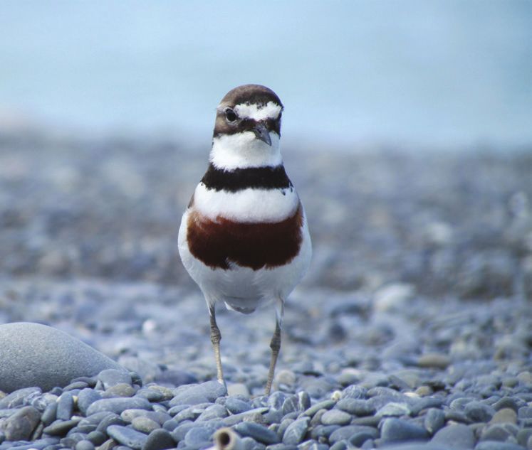
Cover photo: Adult Banded Dotterel (photo by Kevin Stevens)Executive summary Greater Wellington Regional Council’s Flood Protection department is developing an Environmental Code of Practice and an Environmental Monitoring Plan to guide and monitor how all flood protection and erosion mitigation activities are undertaken across the Wellington region. This plan includes a commitment to undertake periodic monitoring of the bird populations found in the river corridors subject to flood and erosion mitigation activities. Although all species of birds encountered in the river corridors are recorded during these surveys, there is a particular emphasis on carrying out census counts of several riverbed-nesting shorebird species, as these are the species most likely to be adversely affected by some of these activities. Between 2012 and 2015, three annual surveys were carried out along 49.7 km of the Ōtaki, Waikanae and Hutt Rivers. The Ōtaki River was found to support the highest diversity and densities of riverbed-nesting shorebirds, with a mean of 3.5 pied stilts, 2.9 banded dotterels and 1.3 black-fronted dotterels counted per km of river. The Ōtaki River populations of both banded and black-fronted dotterels represent 8% of the Wellington region’s breeding populations of these two species. In contrast, only pied stilts were recorded on the Hutt River at a mean density of 0.6 birds per km, and no riverbed-nesting shorebirds were found in the bed of the Waikanae River. Total numbers of species encountered on each river were remarkably similar given major differences in river geomorphology and in the lengths of rivers surveyed, with 48, 45 and 44 bird species recorded respectively on the Ōtaki, Waikanae and Hutt Rivers. Species diversity was fairly uniform along the majority of the lengths of each river, but total species diversity, the ratio of native to exotic species, and the ratio of threatened to non-threatened native species began to increase within ca. 2 km of the coast and reached a maximum at the river estuaries. Eleven ‘sites of value’ for indigenous birds were identified on these rivers as a consequence of these surveys. These include shorebird-nesting habitats, shag nesting colonies, colonial roost sites and the three river estuaries. These results provide a good baseline against which future changes in shorebird population sizes and overall species diversity can be compared. In accordance with the Flood Protection Environmental Monitoring Plan, we recommend that these surveys be repeated again over three consecutive summers between 2020 and 2023. In addition, we provide a number of recommendations for additions or changes to be made to the Environmental Code of Practice and Monitoring Plan as a result of the new information gained from these surveys.
Contents
Executive summary                                                            i

1.      Introduction                                                         1

2.      Methodology                                                          4
2.1     Survey areas                                                         4
2.2     Field methodology                                                    4
2.3     Data management and analysis                                         6

3.      Results                                                              7
3.1     Ōtaki River                                                          7
3.1.1   Riverbed nesting shorebirds                                          7
3.1.2   Spatial patterns in bird species diversity                           9
3.1.3   Sites of value for indigenous birds on the Ōtaki River              11
3.2     Waikanae River                                                      13
3.2.1   Riverbed nesting shorebirds                                         13
3.2.2   Spatial patterns in bird species diversity                          13
3.2.3   Sites of value for indigenous birds on the Waikanae River           13
3.3     Hutt River                                                          16
3.3.1   Riverbed nesting shorebirds                                         16
3.3.2   Spatial patterns in bird species diversity                          18
3.3.3   Sites of value for indigenous birds on the Hutt River               18

4.      Discussion                                                          22
4.1     Management of riverbed nesting shorebirds                           22
4.2     Bird species diversity                                              24
4.3     Sites of value for indigenous birds                                 25

5.      Recommendations                                                     27

Acknowledgements                                                            29

References                                                                  30

Appendices                                                                  32
Appendix 1: NZTM grid references for each 1 km survey section on the
      Ōtaki, Waikanae and Hutt Rivers                                       32
Appendix 2: Bird species recorded on the Ōtaki River during the 2012-
      2015 surveys                                                          34
Appendix 3: Additional bird species recorded on the Ōtaki River since
      1982                                                                  38
Appendix 4: List of bird species recorded on the Waikanae River during
      the 2012-2015 bird surveys                                            40
Appendix 5: Additional bird species recorded on the Waikanae River since
      1927                                                                  43
Appendix 6: List of bird species recorded on the Hutt River during the
      2012-2015 bird surveys                                                47
Appendix 7: Additional bird species recorded on the Hutt River since 1997   50
Baseline monitoring of the birds of the Ōtaki, Waikanae and Hutt Rivers, 2012-2015
1. Introduction
Greater Wellington Regional Council (GWRC) has a statutory responsibility
for flood and erosion mitigation in the Wellington region under section 30 of
the Resource Management Act (1991) and sections 10 and 126 of the Soil
Conservation and Rivers Control Act (1941).
To help fulfil this statutory responsibility, GWRC’s Flood Protection
Department is preparing an Environmental Code of Practice (Code) and an
Environmental Monitoring Plan (EMP) to guide and monitor how all flood
protection and erosion control activities are undertaken across the Wellington
region. The Code is specifically designed to support the vision “that Flood
Protection activities restore and enhance the natural and cultural values
associated with our rivers” (GWRC 2015).
To ensure that the management of GWRC’s flood and erosion mitigation
activities remain aligned with this vision over the 35-year term of the resource
consents required to undertake many of these activities, an adaptive
management approach is being incorporated into the Code and EMP. The aim
of this approach is to improve environmental, social and cultural management
and outcomes through a continuous “learning by doing” cycle of action,
monitoring and evaluation of practice. Together therefore, the Code and EMP
provide a process whereby any negative effects of the day to day flood
protection and erosion control activities carried out by GWRC are minimised
or appropriately mitigated (GWRC 2015).
One of the key ecological values of the rivers that are subject to GWRC’s flood
and erosion mitigation activities is the relatively high number of bird species
that use the river corridors as foraging, roosting or breeding habitat, and the
presence of several species of threatened shorebirds that are highly dependent
on the open gravel habitats present in the beds of these rivers for breeding
(Rebergen 2012; McArthur et al 2013). The importance of these rivers as
habitats for threatened shorebirds has been recently recognised by the inclusion
of eight riverbed “habitats of significance for indigenous birds” in schedule F2
of the Wellington region’s Proposed Natural Resources Plan (GWRC 2015;
McArthur et al 2015) and the identification of a large portion of the
Ruamahanga River and its tributaries as an “Important Bird Area” by Forest
and Bird/Birdlife International (Forest & Bird 2014).
GWRC recognises that there is potential for flood or erosion control activities
to have both positive and negative impacts on bird populations present in the
river corridors (Cameron 2013; Cameron 2015). In response to this, the EMP
includes a commitment by GWRC to undertake periodic monitoring of the bird
populations found in the river corridors subject to flood and erosion control
activities. The results from this monitoring will in turn be used by the (yet to be
formed) Flood Protection Technical Panel to determine whether any changes
detected in local bird populations require either a management or monitoring
response, which would be driven by making the appropriate changes to the
Code or EMP (GWRC 2015).
PAGE 1 OF 51Baseline monitoring of the birds of the Ōtaki, Waikanae and Hutt Rivers, 2012-2015
The bird monitoring programme that GWRC has committed to involves
carrying out annual surveys on a three year on, five year off cycle on most of
the major rivers affected by flood protection activities. These bird surveys will
be carried out on the Ōtaki, Waikanae, Hutt and representative reaches of the
Ruamahanga, Waingawa, Waiohine and Tauherenikau Rivers according to the
methods described in this report, in blocks of three consecutive years separated
by five-year intervals during which no annual surveys will be carried out
(McArthur et al 2013; GWRC 2015).
These river bird surveys are specifically designed to provide estimates of the
local population sizes of four shorebird species that are known to breed on the
open gravels of rivers subject to flood and erosion mitigation activities.
Because breeding populations of these four species are largely restricted to
these riverine gravel habitats in the Wellington region, they are considered to
be at relatively high risk of being adversely impacted by these activities
(Cameron, 2013; Cameron 2015). Furthermore, these four species are all of
relatively high conservation concern nationally. The banded dotterel
(Charadrius bicinctus) is ranked as Nationally Vulnerable under the New
Zealand Threat Classification System, with a predicted national rate of decline
of 30-70% over the next decade. The black-billed gull (Larus bulleri) is ranked
as Nationally Endangered, with a projected rate of decline of >70% over the
same time period. The pied stilt (Himantopus himantopus) is ranked as ‘At
Risk’, Declining, with a predicted rate of decline of 10-50% over 10 years
(Robertson et al 2013). The final species, the black-fronted dotterel (Elseyornis
melanops), is a relatively recent addition to the New Zealand avifauna, having
self-colonised from Australia in the early 1950s (Heather & Robertson 2015).
Although the back-fronted dotterel is not ranked as either Threatened or ‘At
Risk’, the southern North Island is currently the stronghold for this species in
New Zealand (Robertson et al 2007), so agencies with the statutory authority
for river management in the lower North Island have a disproportionately large
responsibility for maintaining populations of this newly-arrived native
shorebird in comparison to agencies operating in other parts of the country.
In contrast to the locally-breeding shorebird species that provide the focus for
this monitoring, the majority of the remaining bird species recorded in the river
corridor are terrestrial species that are common and widespread in the
surrounding landscape, and are considered unlikely to be adversely affected by
the localised effects of flood protection activities occurring in the bed of the
river itself (McArthur et al 2013). A number of additional shorebird and
waterfowl species do make use of the lower reaches and estuaries of these
rivers during certain stages of their life-cycle however, so in addition to
monitoring trends in the population sizes of the four most vulnerable locally-
breeding shorebird species, numbers of non-breeding shorebirds, waterfowl
and terrestrial bird species are also recorded during these surveys. This will
enable broad trends in both the diversity and distribution of these species can
be monitored over time.
The first three-year series of annual bird surveys on the Ōtaki, Waikanae and
Hutt Rivers (the “western sector” rivers) commenced in late 2012, with three
consecutive annual surveys having now been completed in the summers of
2012/13, 2013/14 and 2014/15. This report summarises the results of this first
PAGE 2 OF 51Baseline monitoring of the birds of the Ōtaki, Waikanae and Hutt Rivers, 2012-2015
series of surveys for the “western sector” rivers and provides recommendations
for the timing of future surveys and for several changes to be made to both the
Code and EMP as a consequence of the new information now available as a
result of these surveys.
PAGE 3 OF 51Baseline monitoring of the birds of the Ōtaki, Waikanae and Hutt Rivers, 2012-2015
2. Methodology
2.1 Survey areas
Bird surveys were carried out annually along 49.7 kilometres of the Ōtaki,
Waikanae and Hutt Rivers over three consecutive summers between 2012 and
2015. The majority of the lengths of each of these three rivers that are subject
to flood protection management activities were surveyed in their entirety each
year (Figures 2.1, 2.2 and 2.3).
Figure 2.1: Map of the Ōtaki River, showing the extent of the 2012-2015 bird
surveys
2.2 Field methodology
The survey method was adapted from that used by Rebergen (2012) to survey
shorebirds on several Wairarapa rivers in 2010 and 2011. Surveys were carried
out between the months of October and January each year, on fine and calm
days during periods of “normal”, or relatively low river flows.
During each survey, one or two observers walked slowly along the bed of the
river recording the identity and numbers of all birds seen or heard in the bed of
the river or in the adjacent riparian vegetation. Any birds flying overhead that
were obviously associated with the river habitat (eg waterfowl and shorebirds)
were also counted when flying in a direction perpendicular or opposite to the
direction of travel of the observers. Birds flying in the same direction as the
observers were not counted, to minimise the risk of double-counting birds.
PAGE 4 OF 51Baseline monitoring of the birds of the Ōtaki, Waikanae and Hutt Rivers, 2012-2015
Figure 2.2: Map of the Waikanae River, showing the extent of the 2012-2015 bird
surveys
Figure 2.3: Map of the Hutt River, showing the extent of the 2012-2015 bird
surveys
Special care was made to systematically scan all areas of un-vegetated gravels
and all muddy backwaters to reduce the likelihood of missing territorial pairs
of banded and black-fronted dotterels and pied stilts.
PAGE 5 OF 51Baseline monitoring of the birds of the Ōtaki, Waikanae and Hutt Rivers, 2012-2015
The three observers who carried out these surveys (the authors) each spent at
least one day surveying a section of riverbed together before completing
surveys by themselves. This was done to ensure that each observer was
carrying out their surveys in a consistent manner so that direct comparisons of
count data collected by different observers could be made.
For this survey, two minor additions were made to the survey method used by
Rebergen (2012). Firstly, each river surveyed was broken up into adjacent one
kilometre survey sections, and the identity and number of birds detected within
each section was recorded separately. This methodology was used in order to
create the opportunity to look for spatial patterns in the abundance and
diversity of birds within each river and to enable the identification of discrete
sites or reaches of river that possessed relatively high habitat values for birds.
This approach also creates the opportunity to correlate bird abundance or
diversity with physical habitat variables (eg extent of woody weed cover) or
the Natural Character Index being developed by Massey University researchers
(R. Death pers. comm.). To ensure the repeatability of these surveys, the start
and finish points for each of these one km survey sections have been GPSed
with a Garmin GPSmap 60CSx hand held GPS unit and these grid references
can be found listed in Appendix 1 of this report.
The second addition made to the survey methodology was that the observers
recorded the locations of any nests, nesting colonies, dependent chicks or
colonial roost sites encountered during the surveys using hand held GPS units.
This was completed in order to assist with the identification of any discrete
sites or reaches of river that possessed relatively high habitat values for birds.
2.3 Data management and analysis
River bird survey data were entered into Microsoft Excel spreadsheets which
were then used to calculate the diversity of species recorded along each river
and each 1 km survey section, as well as the relative abundance (mean number
of birds/km/year) of several key riverbed-nesting shorebird species.
This survey data was also entered into the New Zealand eBird database
(http://ebird.org/content/newzealand/), with bird data from each 1 km survey
section being entered as a complete checklist using eBird’s “travelling count”
protocol. This was done to ensure that this data is permanently stored in a
discoverable and easily retrievable location, and to amalgamate this dataset
with a growing archive of bird observations being made by local bird-watchers
and other ‘citizen scientists’ on the Ōtaki, Waikanae and Hutt Rivers.
Locations of all nests, nesting colonies, dependent chicks, colonial roost sites
and sites with relatively high habitat value for indigenous birds were mapped
using ArcMap version 10.1.
PAGE 6 OF 51Baseline monitoring of the birds of the Ōtaki, Waikanae and Hutt Rivers, 2012-2015
3. Results
3.1 Ōtaki River
3.1.1 Riverbed nesting shorebirds
Three species of shorebirds were observed using the dry gravel beaches and
islands of the Ōtaki River during the 2012-2015 surveys. The pied stilt, a
species ranked as ‘At Risk, Declining’ under the New Zealand Threat
Classification System was the most common shorebird species, followed by the
banded dotterel (ranked as Nationally Vulnerable) and the black-fronted
dotterel, a recent coloniser from Australia.
An average of 41 pied stilts was recorded along the 11.6 km of river surveyed
each year, or 3.5 birds per km of river (Table 3.1). Territorial pairs of adult
pied stilts were found to be fairly evenly distributed along the length of the
Ōtaki River, but became uncommon upstream of XS890, and between XS350
and XS260 (from the SH 1 bridge to approximately one km further
downstream) (Figure 3.1). Pied stilts were recorded breeding on the riverbed
between XS120 and XS700, with both nests and chicks observed during these
surveys. During the 2012/2013 survey, a small nesting colony of six breeding
pairs, (each pair of birds incubating a clutch of three eggs), was found on the
gravel island near XS130 (approximately 1.5 km upstream of the Ōtaki River
mouth).
Table 3.1: Numbers of pied stilts, banded dotterels and black-fronted dotterels
counted along the Ōtaki River, 2012-2015
Pied stilt Banded dotterel Black-fronted dotterel
Year Total Number of Total Number of Total Number of
number birds per number birds per number birds per
counted km counted km counted km
2012/2013 41 3.5 38 3.3 11 0.9
2013/2014 22 1.9 18 1.6 11 0.9
2014/2015 59 5.1 45 3.9 23 2.0
Mean ± SD 41 ± 15 3.5 ± 1.3 34 ± 11 2.9 ± 1.0 15 ± 6 1.3 ± 0.5
PAGE 7 OF 51Baseline monitoring of the birds of the Ōtaki, Waikanae and Hutt Rivers, 2012-2015
Figure 3.1: Map of the Ōtaki River showing spatial patterns in the relative abundance of riverbed nesting
shorebirds. Coloured bars represent the mean number of birds counted along each 1 km survey section during
three annual surveys between 2012 and 2015.
PAGE 8 OF 51Baseline monitoring of the birds of the Ōtaki, Waikanae and Hutt Rivers, 2012-2015
An average of 34 banded dotterels was recorded along the Ōtaki River each
year, or 2.9 birds per km of river (Table 3.1). Territorial pairs of adult banded
dotterels were found to be fairly evenly distributed along the length of the
Ōtaki River, but became uncommon upstream of XS890, and between XS350
and XS170 (from the SH 1 bridge to approximately two km downstream)
(Figure 3.1). A relatively high number of non-territorial banded dotterels were
counted between XS90 and XS170 during the second and third year of surveys.
Many of these birds appeared to be part of a small post-breeding flock of both
adult and juvenile birds that were using this stretch of river as a roost site
during late summer. Banded dotterels were recorded breeding on the riverbed
between XS350 (the SH 1 bridge) and XS790, with both nests and chicks
observed during these surveys.
No black-fronted dotterel nests or chicks were found during the 2012-2015
surveys, however the presence of territorial adult pairs along the river during
the breeding season suggests that breeding is almost certainly occurring.
Several pairs were also seen exhibiting various defensive behaviours as
fieldworkers traversed their territories, which also indicated that either a nest or
chicks were present. An average of 15 black-fronted dotterels was recorded
along the Ōtaki River each year, or 1.3 birds per km of river (Table 3.1).
Unlike both banded dotterels and pied stilts, black-fronted dotterels continued
to be recorded both upstream of XS890 and in the reach immediately
downstream of the SH 1 bridge (Figure 3.1).
3.1.2 Spatial patterns in bird species diversity
A total of 48 bird species were recorded on the Ōtaki River during the 2012-
2015 bird surveys, including 30 native species and 18 introduced species. Of
the native species, nine species are ranked as Nationally Threatened or ‘At
Risk’ under the New Zealand Threat Classification System (Appendix 2;
Robertson et al, 2013). In addition to these 48 species recorded during the
2012-2015 surveys, a further 15 species (13 native and two introduced) have
been recorded on the Ōtaki River since 1982 (Appendix 3), bringing the total
number of birds species so far recorded on the Ōtaki River to 63.
Both the total number of species and the ratio of native to introduced species
encountered within each 1 km survey section varied little along the 11.6 km of
the Ōtaki River that was covered during these surveys (Figure 3.2). A lower
total number of species tended to be recorded upstream of XS890 and between
XS350 and XS260 (from the SH 1 bridge to approximately one kilometre
further downstream). In contrast, the Ōtaki Estuary supported a much higher
total number of species, a higher ratio of native to introduced species and a
higher number of Nationally Threatened and ‘At Risk’ species than any other
reach of the Ōtaki River.
PAGE 9 OF 51Baseline monitoring of the birds of the Ōtaki, Waikanae and Hutt Rivers, 2012-2015
Figure 3.2: Map of the Ōtaki River showing spatial patterns in bird species diversity. Coloured bars and
adjacent values represent the mean number of species detected along each 1 km survey section during three
annual surveys between 2012 and 2015
PAGE 10 OF 51Baseline monitoring of the birds of the Ōtaki, Waikanae and Hutt Rivers, 2012-2015
3.1.3 Sites of value for indigenous birds on the Ōtaki River
Four sites of value for native birds have been identified on the Ōtaki River
based on the data collected during these surveys (Figure 3.3).
Virtually the entire length of the 11.6 km of the Ōtaki River surveyed, between
the Ōtaki Estuary and XS1040 provides breeding habitat for regionally-
significant populations of both banded and black-fronted dotterels, and for a
relatively large local breeding population of pied stilts. Approximately 8% of
the Wellington region populations of both banded and black-fronted dotterels
breed on the Ōtaki River (McArthur et al, 2015).
A previously un-documented nesting colony of black shags (Phalacrocorax
carbo; a species ranked as ‘At Risk, Naturally Uncommon’) was discovered on
the escarpment on the true right of the Ōtaki River at XS970 during the first
year of these surveys, with nesting activity also observed during the second and
third years’ surveys. Only two to three occupied nests were observed at the
colony each year during these surveys, however peak egg-laying at inland
black shag colonies in the Wellington Region occurs between April and
October so the colony is likely to support a greater number of pairs than the
results of these surveys suggest (Powlesland et al, 2007). Although the colony
itself is situated on the escarpment well above the bed of the Ōtaki River, both
adult black shags and recently-fledged juveniles from the colony were
observed using the adjacent river channel and riverbed for foraging and
roosting. This colony is one of only eight black shag nesting colonies known to
be active in the Wellington region at the present time (Birds New Zealand,
unpublished data).
The lower reach of the Ōtaki River between XS90 and XS170 appears to be
utilized by banded dotterels as a post-breeding staging area prior to migration.
In late summer (January), a relatively high number of non-territorial adult and
juvenile dotterels roost in this downstream reach of the river before departing
on migration.
The Ōtaki Estuary supports a relatively high total number of bird species, a
relatively high number of Nationally Threatened and ‘At Risk’ species, and a
higher ratio of native to introduced bird species than any other reach of the
Ōtaki River.
PAGE 11 OF 51Baseline monitoring of the birds of the Ōtaki, Waikanae and Hutt Rivers, 2012-2015
Figure 3.3: Map of the Ōtaki River showing bird sites of value identified as a result of the 2012-2015 bird surveys
PAGE 12 OF 51Baseline monitoring of the birds of the Ōtaki, Waikanae and Hutt Rivers, 2012-2015
3.2 Waikanae River
3.2.1 Riverbed nesting shorebirds
No shorebirds were observed breeding on the dry gravel beaches of the
Waikanae River during the 2012-2015 surveys, however a pair of variable
oystercatchers (Haematopus unicolor) was seen with a downy chick at the
Waikanae Estuary during the 2014/2015 survey. Pied stilts and banded
dotterels have also been recorded nesting at the Waikanae Estuary in the past
(Kirk & Wodzicki 1943; Wodzicki 1946). The morphology of the Waikanae
River between the SH 1 bridge and the Waikanae Estuary, particularly the
narrow channel width and relatively small areas of open, dry gravel habitat
means that there is currently very little (if any) suitable habitat to support
riverbed-nesting shorebirds (N. McArthur pers. obs).
3.2.2 Spatial patterns in bird species diversity
A total of 45 bird species were recorded during the 2012-2015 bird surveys,
including 27 native species and 18 introduced species. Of the native species,
nine species are ranked as Nationally Threatened or ‘At Risk’ under the New
Zealand Threat Classification System (Appendix 4; Robertson et al, 2013). In
addition to these 45 species recorded during the 2012-2015 surveys, a further
45 species (42 native and three introduced) have been recorded on the
Waikanae River (the majority at the Waikanae Estuary) since 1927 (Appendix
5), bringing the total number of bird species so far recorded on the Waikanae
River to 90.
Both the total number of species and the ratio of native to introduced species
encountered within each 1 km survey section varied little upstream of XS155.
However, the total number of species, the proportion of native species, and the
proportion of Nationally Threatened and ‘At Risk’ species encountered
gradually increased downstream from this point, with the highest number of
species being detected at the Waikanae River mouth (Figure 3.4).
3.2.3 Sites of value for indigenous birds on the Waikanae River
One site of value for native birds was identified on the Waikanae River based
on the data collected during these surveys, and this was the Waikanae Estuary
and its associated wetlands and ponds (Figure 3.5).
This site supports a relatively high total number of bird species, a relatively
high number of Nationally Threatened and ‘At Risk’ species, and a higher ratio
of native to introduced bird species than any other reach of the Waikanae
River. In addition, the wetlands associated with the Waikanae River mouth
support one of only two known populations of North Island fernbird
(Bowdleria punctata) in the Wellington Region, and one of the largest nesting
colonies of pied shags (Phalacrocorax varius) in the region. As well as
supporting a relatively high diversity of resident native bird species, this
estuary is also a regionally important stop-over site for several migrant
shorebird species including South Island pied oystercatcher (Haematopus
finschi), bar-tailed godwit (Limosa lapponica) and black-fronted tern
(Chlidonias albostriatus).
PAGE 13 OF 51Baseline monitoring of the birds of the Ōtaki, Waikanae and Hutt Rivers, 2012-2015
Figure 3.4: Map of the Waikanae River showing spatial patterns in bird species diversity. Coloured bars and
adjacent values represent the mean number of species detected along each 1 km survey section during three
annual surveys between 2012 and 2015.
PAGE 14 OF 51Baseline monitoring of the birds of the Ōtaki, Waikanae and Hutt Rivers, 2012-2015
Figure 3.5: Map of the Waikanae River showing the location of the Waikanae Estuary ‘bird site of value’
PAGE 15 OF 51Baseline monitoring of the birds of the Ōtaki, Waikanae and Hutt Rivers, 2012-2015
3.3 Hutt River
3.3.1 Riverbed nesting shorebirds
One species of shorebird (pied stilt) was observed using the dry gravel beaches
along parts of the Hutt River during the 2012-2015 surveys. Although no nests
or chicks were located, the presence of territorial pairs in suitable habitat
during this species’ breeding season suggests that these birds are likely to be
breeding on the Hutt River. Several pied stilt pairs were also seen exhibiting
various defensive behaviours as fieldworkers traversed their territories, which
also provides circumstantial evidence that either a nest or chicks were present.
An average of 20 pied stilts was recorded along the 31.5 km of river surveyed
each year, or 0.6 birds per km of river (Table 3.2). Pied stilts pairs were not
evenly distributed along the Hutt River however. Instead, these birds were
concentrated in two discrete reaches of the river, between XS1310 and XS2270
(from the Silverstream Weir to the eastern end of Awa Kairangi Park) and
between XS2730 and XS2900 (alongside the Te Marua golf course) (Figure
3.6).
Table 3.2: Numbers of pied stilts counted along the Hutt River, 2012-2015
Year Total number counted Number of birds per km
2012/2013 11 0.3
2013/2014 20 0.6
2014/2015 28 0.9
Mean ± SD 20 ± 7 0.6 ± 0.2
PAGE 16 OF 51Baseline monitoring of the birds of the Ōtaki, Waikanae and Hutt Rivers, 2012-2015
Figure 3.6: Map of the Hutt River showing the spatial pattern in the relative abundance of pied stilts. Coloured
bars and adjacent values represent the mean number of birds counted along each 1 km survey section during
three annual surveys between 2012 and 2015.
PAGE 17 OF 51Baseline monitoring of the birds of the Ōtaki, Waikanae and Hutt Rivers, 2012-2015
3.3.2 Spatial patterns in bird species diversity
A total of 44 bird species were recorded during the 2012-2015 bird surveys,
including 26 native species and 18 introduced species. Of the native species,
seven species are ranked as Nationally Threatened or ‘At Risk’ under the New
Zealand Threat Classification System (Appendix 6; Robertson et al, 2013). In
addition to these 44 species recorded during the 2012-2015 surveys, a further
18 species (all native) have been recorded on the Hutt River since 1997
(Appendix 7), bringing the total number of bird species so far recorded on the
Hutt River to 62.
Both the total number of species and the ratio of native to introduced species
encountered within each 1 km survey section varied little along the 31.5 km of
the Hutt River that was surveyed (Figure 3.7). A slightly higher proportion of
Nationally threatened and ‘At Risk’ species were recorded between XS1310
and XS2270 (from the Silverstream Weir to the eastern end of Awa Kairangi
Park) and between XS2730 and XS2900 (alongside the Te Marua golf course),
due largely to the presence of both pied stilts and black shags on the riverbed
within these reaches. The total number of species recorded, the ratio of native
to introduced species and the proportion of threatened and ‘at risk’ species all
increased with increasing distance downstream of XS540. This change was due
to the presence of greater numbers of predominately coastal bird species such
as red-billed gulls (Larus novaehollandiae), royal spoonbills (Platalea regia),
pied shags and variable oystercatchers in this lower reach of the Hutt River.
3.3.3 Sites of value for indigenous birds on the Hutt River
Six sites of value for native birds have been identified on the Hutt River based
on the data collected during these surveys (Figure 3.8).
The two reaches of the Hutt River, between XS1310 and XS2270 (from the
Silverstream Weir to the eastern end of Awa Kairangi Park) and between
XS2730 and XS2900 (alongside the Te Marua golf course) are likely to be
providing breeding habitat for 10-15 pairs of pied stilts, or 1-2% of the regional
population of this “At Risk – Declining” species (McArthur et al, 2015).
Two small nesting colonies of black shags are also present on the Hutt River,
one near XS2920 (opposite the Te Marua golf course) and one near XS490
(near the Melling Bridge). The Te Marua colony contained 3-5 occupied nests
each year between 2012 and 2015 and the Melling colony contained 2-7 nests.
Peak egg-laying at inland black shag colonies in the Wellington region occurs
between April and October however, so these colonies likely support a greater
number of pairs than the results of these surveys suggest (Powlesland et al,
2007). Although both colonies are situated on escarpments well above the bed
of the Hutt River, both adult black shags and recently-fledged juveniles from
the colonies were observed using the adjacent river channel and riverbed for
foraging and roosting. These colonies are two of only eight black shag nesting
colonies known to be active in the Wellington region at the present time (Birds
New Zealand, unpublished data). The Melling colony site has been used as a
nocturnal roost by black shags since at least 1993, with one prior breeding
attempt recorded at the site in June 1994. The Te Marua colony was first
PAGE 18 OF 51Baseline monitoring of the birds of the Ōtaki, Waikanae and Hutt Rivers, 2012-2015
discovered in October 1994, with breeding occurring in 1994 and 1995
(Powlesland et al, 2007).
A large gravel island that is exposed at low tide near XS190 (just downstream
of the Ava railway bridge) provides an important roost site for a number of
threatened shorebird species, including royal spoonbills, black shags, little
black shags (Phalacrocorax sulcirostris), pied shags, variable oystercatchers,
pied stilts and Caspian terns (Hydroprogne caspia) (New Zealand eBird
database; accessed 12/06/2015). Gravel beaches either side of the Silverstream
road bridge (XS1400) are also used as a roost site by large numbers of black-
backed gulls (Larus dominicanus), however black-backed gulls lack legal
protection and are classified as “Not Threatened” under the New Zealand
Threat Classification System (Robertson et al, 2013). This, and the fact that
their presence at this location is more likely to be a consequence of the
proximity of the Silverstream Landfill, leads us to consider that this latter roost
site should not be considered as a “site of value” for native birds.
The Hutt Estuary, upstream to XS150 supports a relatively high number of
Nationally Threatened and ‘At Risk’ species, and a higher ratio of native to
introduced bird species than any other reach of the Hutt River.
PAGE 19 OF 51Baseline monitoring of the birds of the Ōtaki, Waikanae and Hutt Rivers, 2012-2015
Figure 3.7: Map of the Hutt River showing spatial patterns in bird species diversity. Coloured bars and adjacent
values represent the mean number of species detected along each 1 km survey section during three annual
surveys between 2012 and 2015.
PAGE 20 OF 51Baseline monitoring of the birds of the Ōtaki, Waikanae and Hutt Rivers, 2012-2015
Figure 3.8: Map of the Hutt River showing bird sites of value identified as a result of the 2012-2015 bird surveys
PAGE 21 OF 51Baseline monitoring of the birds of the Ōtaki, Waikanae and Hutt Rivers, 2012-2015
4. Discussion
4.1 Management of riverbed nesting shorebirds
These surveys demonstrate that the Ōtaki River supports the highest diversity
and abundance of riverbed nesting shorebirds among the three “western sector”
rivers that were surveyed. Around 8% of the Wellington region’s populations
of both banded and black-fronted dotterels breed on the Ōtaki River each year,
along with 3% of the Wellington region’s population of pied stilts (McArthur
et al 2015; GWRC unpublished data). These surveys also show that the Ōtaki
River supports the largest populations of both banded and black-fronted
dotterels on the west coast of the North Island south of the Manawatu River.
Annual counts of these species varied from year to year. Counts for both
banded dotterels and pied stilts were lower than average in year two, which is
likely to be because the Ōtaki River was surveyed relatively late in the season
that year, and a number of the birds encountered appeared to have finished
breeding. It is possible therefore that a proportion of the birds in the local
breeding population had already vacated their breeding territories that year so
were not included in the count. In year three, numbers of banded and black-
fronted dotterels and pied stilts counted were all higher than average, possibly
the result of a particularly successful breeding season.
Given this relatively high diversity and abundance of shorebirds and their
relatively uniform distribution along the length of the Ōtaki River influenced
by flood protection activities, it’s on the Ōtaki River that these activities have
the greatest potential to have either beneficial or adverse effects on riverbed-
nesting birds.
There is some anecdotal evidence that at the catchment scale, the disturbance
regime created by flood protection activities is having a net positive effect on
the abundance and breeding success of riverbed nesting shorebirds. Activities
such as gravel extraction, beach ripping and contouring help prevent the
invasion of open gravel habitats by exotic woody weeds, which in turn may
reduce the impacts of introduced mammalian predators on dotterel nesting
success (Sim 1997; Rebergen 2011; Rebergen 2012). The authors of this report
noted that the Ōtaki River banded dotterels appeared to have experienced
relatively high nest success rates during each of the three previous summers,
with many of the breeding pairs encountered during these surveys observed
with young chicks. In contrast, simultaneous monitoring of two coastal banded
dotterel populations at both Pencarrow Head and Baring Head/Ōrua-pouanui
showed that these populations were experiencing nest failure rates in excess of
90%, so the majority of pairs at these latter two sites were incubating clutches
of eggs at the same time of year (GWRC unpublished data).
Nonetheless, despite these net positive effects possibly occurring at the
catchment scale, it’s likely these effects are being limited by the local losses of
nests and chicks as a direct consequence of the mechanical disturbance of open
gravel habitats during gravel extraction, beach ripping or contouring activities
(Figure 4.1). The lowering of gravel beaches during contouring or gravel
extraction activities may also lead to nests and chicks being more prone to
being washed away by floods (Rebergen 2012).
PAGE 22 OF 51Baseline monitoring of the birds of the Ōtaki, Waikanae and Hutt Rivers, 2012-2015
Figure 4.1: Pied stilt nest (foreground, centre) on the Ōtaki River with gravel
beach ripping in progress in the background, November 2012
GWRC’s Environmental Code of Practice seeks to minimise these local losses
of nests or chicks by stipulating that any activities causing disturbance to dry
gravel beaches during the shorebird breeding season (1st Aug to 28th Feb) be
preceded by a survey of the affected area to determine whether any shorebird
nests or chicks are present (GWRC 2015). Should active nests or broods of
chicks be detected, exclusion zones will be maintained where possible around
nests and chicks to minimise the risk of accidentally crushing eggs or chicks, or
nest abandonment by adults. The extent of these exclusion zones (which vary
according to the type or duration of habitat disturbance being imposed) are not
currently specified in the Code, but can be found listed in both Cameron (2013)
and McArthur et al (2013).
The Environmental Monitoring Plan includes a series of “trigger levels”
against which the success or otherwise of the measures included in the Code
can be measured. These “trigger levels” represent rates of decline in the Ōtaki
PAGE 23 OF 51Baseline monitoring of the birds of the Ōtaki, Waikanae and Hutt Rivers, 2012-2015
River shorebird populations above which a review of the current management
and/or monitoring regime would be triggered (Table 4.1).
Table 4.1: Adaptive management trigger levels for river-bed nesting birds on the
Ōtaki River (GWRC, 2015)
Species Trigger level
25% or more decline in the average number of breeding pairs detected between
Banded dotterel
one 3-year set of surveys and the next
25% or more decline in the average number of breeding pairs detected between
Pied stilt
one 3-year set of surveys and the next
Black-fronted 50% or more decline in the average number of breeding pairs detected between
dotterel one 3-year set of surveys and the next
If the cause of a population decline is obvious, and can be reliably linked to
flood protection activities (eg a significant observed increase in the proportion
of dry gravel habitat being disturbed during the shorebird breeding season),
then a review of the Code would be the most appropriate response. However, a
much more likely scenario is that the cause of an observed population decline
is not obvious, and in this situation a review of the EMP would be more
appropriate. In this latter case, a targeted investigation aimed at identifying the
cause of any local decline in shorebirds would likely be required. Such an
approach has recently been successfully applied to identify the cause of
breeding failure in two populations of coastal-breeding banded dotterels in the
Wellington region (Pencarrow Head and Baring Head/Ōrua-pouanui). In this
case, digital trail cameras were used to film dotterel nests and it was
demonstrated that depredation by hedgehogs was accounting for 60% of nest
failures in these two populations. The implementation of hedgehog control in
response to this finding led to a 500-700% increase in the nesting success of
dotterels at these two sites over the next two subsequent breeding seasons
(GWRC unpublished data).
The Hutt River was the only other of the three “western sector” rivers to
provide habitat for riverbed-breeding shorebirds. Between 1-2% of the
Wellington region’s pied stilt population breeds on two discrete sections of the
Hutt River between the Silverstream weir and the Te Marua Water Treatment
Plant. These birds are likely to be similarly affected by GWRC’s flood and
erosion mitigation activities, so similar management precautions to those used
on the Ōtaki River should be adopted for these specific river reaches (see
recommendations section below).
4.2 Bird species diversity
Very similar numbers of bird species were recorded along the Ōtaki, Waikanae
and Hutt Rivers during these surveys (48, 45 and 44 species respectively),
despite large differences in the geomorphology and lengths of each river
surveyed. All three rivers showed similar spatial patterns in species diversity,
with relatively consistent numbers of species, and a consistent ratio of native to
exotic species along most of the surveyed length of each river. Species
diversity, the ratio of native to exotic species and the ratio of Nationally
PAGE 24 OF 51Baseline monitoring of the birds of the Ōtaki, Waikanae and Hutt Rivers, 2012-2015
Threatened and ‘At Risk’ to non-threatened species tended to increase within
1-2 km of the mouth of each river, reaching a maximum at each estuary.
In contrast, numbers of additional bird species recorded on each river outside
of these annual surveys varied markedly, with 45 additional species recorded
on the Waikanae River, 15 species recorded on the Ōtaki River and 18 species
on the Hutt River. Most of these additional species recorded on each river were
observed at the estuaries, due to a traditional concentration of search effort in
these habitats by both recreational birdwatchers and ornithologists. The
Waikanae Estuary has a particularly long tradition of being monitored by local
birdwatchers, including leading ornithologists such as Sir Charles Fleming, Sir
Robert Falla and Dr Kazimierz Wodzicki, so the very high total number of
species recorded for this river can partly be explained by a higher level of
search effort. However, the Waikanae Estuary is also likely to provide better
quality bird habitat than either the Hutt or Ōtaki Estuaries. The Waikanae is
several times larger than the Hutt Estuary, and is composed predominantly of
soft sediments rather than the stony & cobbly substrates of the Ōtaki Estuary.
These differences mean that the Waikanae Estuary probably provides a much
greater area of higher-quality foraging habitat for shorebirds than either the
Hutt or Ōtaki Estuaries.
The appendices to this report attempt to bring together bird records collected
during these surveys with published observations collected by other
birdwatchers and ornithologists over the past 90 years. These species lists are
not yet likely to be complete, but probably represent the most up-to-date
published species lists currently available for each of these rivers.
4.3 Sites of value for indigenous birds
A total of eleven sites of value for indigenous birds have been identified on
these western sector rivers from data collected during these surveys. This
includes four sites on the Ōtaki River, one site on the Waikanae River and six
sites on the Hutt River.
The majority of the bed of the Ōtaki River, and two discrete reaches of the Hutt
River have been identified as sites of value due to the presence of one or more
species of riverbed-nesting shorebird. The Ōtaki River shorebird-nesting
habitat had already previously been identified as a “habitat of significance for
indigenous birds” and has been listed in schedule F2 of the Proposed Natural
Resources Plan (GWRC 2015; McArthur et al 2015).
A second, smaller reach of the lower Ōtaki River has also been identified as a
site of value, due to it regularly being used as a staging area by post-breeding
flocks of both adult and juvenile banded dotterels near the end of the summer
breeding season. This area falls within the previously mentioned shorebird
nesting ‘site of value’ (Figure 3.3).
Three black shag nesting colonies were also identified during the course of
these surveys, one near XS970 on the Ōtaki River, and two further colonies on
the Hutt River, near Melling Bridge and opposite the Te Marua Golf course.
The Ōtaki River colony appears to be previously un-documented, whereas the
Hutt River colonies have been known to be present since at least the early
PAGE 25 OF 51Baseline monitoring of the birds of the Ōtaki, Waikanae and Hutt Rivers, 2012-2015
1990s (Powlesland et al 2007). Only eight black shag nesting colonies are
known to be active in the Wellington region at the present time (Birds New
Zealand, unpublished data).
All three river estuaries have been identified as sites of value for indigenous
birds due to the high number of native species, and the relatively high number
of threatened and ‘at risk’ species that use these habitats. The Ōtaki Estuary has
been designated a “Key Native Ecosystem” by Greater Wellington Regional
Council and the Waikanae Estuary site includes the Waikanae Estuary
Scientific Reserve. All three estuaries have been previously identified as “sites
of significance for indigenous birds” and have been listed in schedule F2 of the
Proposed Natural Resources Plan (GWRC 2015; McArthur et al 2015).
Lastly, a small gravel island just downstream of the Ava Rail Bridge on the
Hutt River has also been identified as a site of value for indigenous birds. This
site provides low-tide roosting habitat for a range of threatened and ‘at risk’
shorebird species. It’s interesting to note that this site was identified solely
from bird observations collected by local bird-watchers and submitted to the
New Zealand eBird database. Because this island is exposed only at low tide,
and the birds that use it for roosting are therefore transitory, these three annual
surveys were insufficient to identify this as a site of value. In contrast,
birdwatchers have been keeping a regular eye on this site over a number of
years, with many useful observations being collected, sometimes by people
commuting to and from Wellington on passing trains. Because these
observations have been submitted to the New Zealand eBird database, and have
been verified by the database’s filters and expert reviewers, we were able to
use the data to identify this as a site of value. This example illustrates the
potential contribution that appropriately-skilled ‘citizen scientists’ can make
towards monitoring trends in the diversity and abundance of birds at key sites,
provided their data is stored in a location that enables it to be validated as well
as discovered and retrieved.
PAGE 26 OF 51Baseline monitoring of the birds of the Ōtaki, Waikanae and Hutt Rivers, 2012-2015
5. Recommendations
This report provides a baseline description of the diversity, abundance and
distribution of birds on the Ōtaki, Waikanae and Hutt Rivers, against which
any future changes can be measured. As specified in GWRC’s Flood Protection
Environmental Monitoring Plan, a second round of annual river bird counts
should be scheduled to be carried out between October and December in 2020,
2021 and 2023. This next series of surveys will provide GWRC with the first
opportunity to assess trends in the population sizes of riverbed-nesting
shorebirds on the Ōtaki River and parts of the Hutt River. These trends can
then be compared to the trigger levels described in the Environmental
Monitoring Plan, which will determine whether or not a management and/or
monitoring response will be required.
We recommend that the Flood Protection department updates its spatial GIS
database of river values, adding records describing the 11 bird sites of value for
indigenous birds that have been identified in this report and that are mapped in
Figures 3.3, 3.5 and 3.8.
We also recommend that the following changes be made to the Code of
Practice and Environmental Monitoring Plan:
The wording of the Code should be modified to specify that flood and
erosion mitigation activities causing disturbance to dry gravels on the
Ōtaki River and parts of the Hutt River should be programmed outside of
the shorebird nesting season whenever possible. Where this is not possible,
these works should be preceded by a survey carried out by an
appropriately experienced ornithologist to identify the presence of
shorebird nests or chicks. Adopting these practices should minimise the
costs associated with carrying out pre-works shorebirds surveys and the
extent to which activities are disrupted by the presence of nests and chicks,
while at the same time minimising adverse impacts of these activities on
shorebird species that are present.
The Code should be updated to reflect new information on the presence of
a breeding population of pied stilts on the Hutt River between XS1310 and
XS2270 and between XS2731 and XS2900. To maintain consistency in the
Code, it is appropriate that a restriction period applicable to these two
reaches be added to Table 6 of the Code, specifying that works on dry
gravels between 1st August and 28th Feb should be avoided where possible.
When such work must be carried out during the shorebird nesting season,
they should be preceded by a survey for pied stilt nests and chicks, carried
out by an appropriately experienced ornithologist.
In addition, an appropriate trigger level for the Hutt River pied stilt
population should be added to the EMP to provide a mechanism by which
the Flood Protection department can devise an appropriate response to any
potential future decline observed in this population. We recommend that
the trigger level specified in Table 5.1 be added to the EMP.
PAGE 27 OF 51Baseline monitoring of the birds of the Ōtaki, Waikanae and Hutt Rivers, 2012-2015
Table 5.1: Recommended trigger level for the Hutt River pied stilt population
Species Trigger level
50% or more decline in the average number of breeding pairs
Pied stilt
detected between one 3-year set of surveys and the next
The Code should be updated to specify the exclusion zones that should be
maintained around shorebird nests or chicks by people or machinery
working on dry gravels during the shorebird breeding season. These
exclusion zones can be found in listed Cameron (2013) and McArthur et al
(2013).
We also recommend that a pilot trial be carried out on the Ōtaki River during
an upcoming shorebird nesting season to test the efficacy of these proposed
pre-works surveys and the maintenance of exclusion zones around any nests or
broods of young chicks found. This will allow GWRC to assess the
effectiveness of these methods as a means of minimising the local losses of
nests and chicks as a consequence of Flood Protection activities and will
provide an opportunity to estimate the costs involved with this work. It would
also be useful to test this technique in the field before the Code and EMP are
finalised so that the published version of the Code contains a method that is
proven to be feasible to implement in the field.
PAGE 28 OF 51Baseline monitoring of the birds of the Ōtaki, Waikanae and Hutt Rivers, 2012-2015
Acknowledgements
We’d like to thank Annette Harvey for her assistance with these field surveys, and for
collecting the bulk of the Pencarrow Head and Baring Head/Ōrua-pouanui banded
dotterel nest success data referred to in this report. We’d also like to thank Graham
Winterburn and Grant Timlin for assistance with access and survey logistics, and Phillip
Cook and Alistair Allan for their help with preparing the maps. This work also
benefitted substantially from the field surveys, observations and recommendations made
by Aalbert Rebergen and Dave Sim, and from several useful discussions with David
Cameron. We’d also like to thank the many local birdwatchers who have taken the time
to record their observations of the birds of the Ōtaki, Waikanae and Hutt Rivers into the
New Zealand eBird database. We are very grateful to Philippa Crisp and Colin Miskelly
for reviewing earlier drafts of this report and to Marianne Miller for her assistance with
formatting and publishing.
PAGE 29 OF 51Baseline monitoring of the birds of the Ōtaki, Waikanae and Hutt Rivers, 2012-2015 References Cameron D. 2013. Effects of Flood Protection Activities on Aquatic and Riparian Ecology in the Ōtaki River. Report prepared for Greater Wellington Regional Council (Flood Protection), MWH, Wellington. Cameron D. 2015. Effects of Flood Protection Activities on Aquatic and Riparian Ecology in Rivers of the Wairarapa Valley. Report prepared for Greater Wellington Regional Council (Flood Protection), MWH, Wellington. Falconer ML, Fleming CA and Wodzicki KA 1973. Birdlife at Waikanae Estuary. Unpublished booklet held in the Greater Wellington Regional Council library, Wellington. Forest and Bird 2014. New Zealand seabirds: Important Bird Areas and conservation. The Royal Forest and Bird Protection Society of New Zealand, Wellington, New Zealand. Gill BJ (Convener), Bell BD, Chambers GK, Medway DG, Palma RL, Scofield RP, Tennyson AJD and Worthy TH. 2010. Checklist of the birds of New Zealand, Norfolk and Macquarie Islands, and the Ross Dependency, Antarctica. Te Papa Press, Wellington. Greater Wellington Regional Council. 2015. Proposed Natural Resources Plan for the Wellington Region – Te Tikanga Taiao o Te Upoko o Te Ika a Maui. Greater Wellington Regional Council, Publication No. GW/EP-G-15/44. Greater Wellington Regional Council. 2015. Environmental Code of Practice and Monitoring Plan for Flood Protection activities. Draft report, Document # 1162876, Greater Wellington Regional Council, Wellington. Kirk AA and Wodzicki KA. 1943. One year of bird observations at Waikanae River Estuary. N. Z. Bird Notes 1: 3-8. McArthur N, Playle S and Govella S. 2013. Diversity, abundance and distribution of birds on selected rivers in the Wellington Region. Unpublished report, Document #254006, Greater Wellington Regional Council, Wellington. McArthur N, Robertson H, Adams L and Small D. 2015. A review of coastal and freshwater habitats of significance for indigenous birds in the Wellington region. Greater Wellington Regional Council, Publication No. GW/ESCI-T-14/68, Wellington. Powlesland RG, Munro AR and Westbrooke IM. 2007. Black shag (Phalacrocorax carbo): roost counts at Melling, Hutt Valley, and breeding in the Wellington Region, New Zealand. Notornis 54: 93-98. Rebergen A. 2011. River bird numbers on Ruamahanga, Waingawa, Waiohine and Tauherenikau Rivers, Wairarapa in spring 2010. Forest and Bird, Wellington. Rebergen A. 2012. Birds on Wairarapa rivers and coast in 2011-2012 breeding season. Unpublished report prepared for Greater Wellington Regional Council, Forest and Bird, Wellington. PAGE 30 OF 51
You can also read