Blue Hills State Reservation - Deer Management Plan Final Draft: October 14, 2015 - Mass.gov
←
→
Page content transcription
If your browser does not render page correctly, please read the page content below
Blue Hills State Reservation
Deer Management Plan
Final Draft: October 14, 2015
A Joint Publication of the
Massachusetts Department of Conservation & Recreation and
the Massachusetts Division of Fisheries & Wildlife
Executive Office of Energy & Environmental Affairs
Commonwealth of Massachusetts
Commonwealth of Massachusetts
Charles D. Baker
Governor

Karyn E. Polito
Lt. Governor

Executive Office of Energy & Environmental Affairs
Matthew A. Beaton
Secretary

                                  Department of Conservation & Recreation
                                                             Carol I. Sanchez
                                                               Commissioner

                                                 Department of Fish & Game
                                                         George Peterson, Jr.
                                                              Commissioner

                               Massachusetts Division of Fisheries & Wildlife
                                                                 Jack Buckley
                                                                      Director

                                                                                 2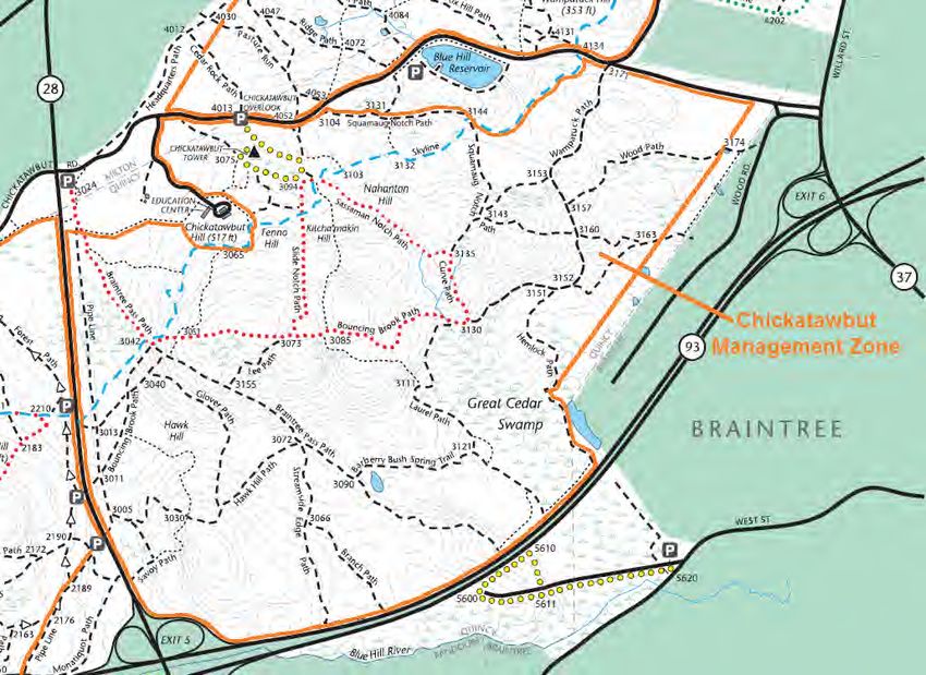
Table of Contents

1.0   Context & Background                                                             4
      1.1   The DCR Blue Hills Reservation
      1.2   Description of the Problem
      1.3   Deer Abundance Surveying in the Blue Hills
      1.4   Deer Management Planning Efforts

2.0   Overview of Alternative Deer Management Approaches                               8
      2.1 No Action
      2.2 Non-Lethal Action
      2.3 Lethal Action

3.0   Deer Impact Management for the Blue Hills Reservation                            11
      3.1 Recommended Deer Management Option
      3.2 Rationale and Objectives for Deer Management in the Blue Hills Reservation

4.0   Proposed Blue Hills Reservation Controlled Hunt Program                          13
      4.1 Controlled Hunt Program Components
      4.2 Year 1 Program Components
      4.3 Subsequent Years

5.0   Overview of Vegetation Monitoring Efforts                                        22
      5.1   Deer Exclosures
      5.2   Vegetation Sampling
      5.3   Data Collection
      5.4   Continuous Forestry Inventory Plots

                                                                                            3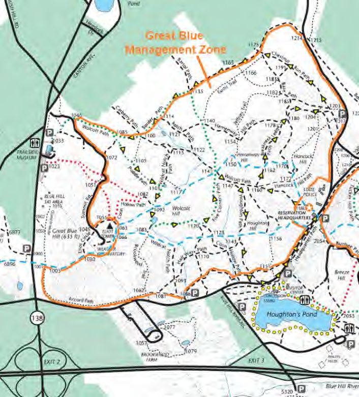
1.0 Context & Background:

1.1 The DCR Blue Hills Reservation
The Massachusetts Department of Conservation and Recreation
(DCR) manages and stewards the Blue Hills Reservation. The
Reservation encompasses an area of over 7,000 acres and is situated
less than ten miles south of downtown Boston in the communities of
Braintree, Canton, Dedham, Milton, Quincy, and Randolph. A small
portion of Fowl Meadow (north and west of the Neponset River) is
located within the Hyde Park neighborhood of the City of Boston. The
protection of this area as public open space began over 120 years ago
with its establishment in 1893 by the Metropolitan Park Commission.
Since that time, the Reservation has served to provide the residents
of greater Boston and surrounding communities with valuable access
to outdoor recreation and a spectacular setting to appreciate the
natural world. On a daily basis, visitors to the Blue Hills Reservation enjoy and partake in a wide variety of
activities such as hiking, mountain biking, wildlife observation, dog walking, horseback riding, rock climbing,
picnicking, swimming, fishing, cross-country and downhill skiing, camping, and golfing.

As a public parkland and forested area, the Reservation contains a wide variety of natural resources,
vegetation, wildlife, and cultural and archaeological resources, and its topography includes prominent hills,
(Great Blue Hill and Chickatawbut Hill), as well as open fields, and several ponds and streams. Unlike most
larger properties and facilities managed by the DCR throughout the Commonwealth, the Blue Hills Reservation
is surrounded by a highly urbanized area, and it is estimated that more than four million people live within a 28-
mile radius of the Blue Hills. Using 2000 Census data when developing a Resource Management Plan (RMP) 1 for
the Reservation, DCR planners also estimated that within a five-mile radius of the Blue Hills there are over
650,000 people and nearly 250,000 households.2

1.2 Description of the Problem
In DCR’s RMP for the Blue Hills Reservation, agency planners noted a growing concern over the size of the
white-tailed deer population within the Reservation. Specifically, the RMP identified high deer population
densities as having resulted in notable and considerable levels of over-browse on the Reservation’s vegetation,
which ultimately can prevent healthy forest regeneration. From the perspective of long-term forest
management, tree regeneration is critical to the survival of forests and their ability to recover from natural
disturbances (i.e., fires, pests, wind). In addition, the plan noted that the Massachusetts Natural Heritage and
Endangered Species Program (NHESP) determined that some of the Reservation’s rare plants had been
negatively affected by deer over-browse and that the need to control the size of the deer population should be
considered in order to reduce deer herbivory on rare plants. Moreover, the RMP noted that, “over-browsing
has the potential to significantly decrease species diversity and suppress canopy cover for decades.” 3

One of the primary goals of the Blue Hills RMP is to protect the most at -risk natural resources within the
Reservation. In this context, the RMP explicitly recommended that the agency “work with the Massachusetts

1
     The DCR is guided by a legislative mandate (M.G.L. c. 21, §2F) to prepare management plans for state parks, reservations, and forests
     under the Department’s care are custody. These Resource Management Plans are developed pursuant to a public process and mu st be
     approved by the DCR Stewardship Council.
2
    Massachusetts Department of Conservation and Recreation, Resource Management Plan: Blue Hills Planning Unit (2011), p. 26,
    http://www.mass.gov/eea/docs/dcr/stewardship/rmp/bh/sections1-4.pdf.
3
    Ibid, p. 154, http://www.mass.gov/eea/docs/dcr/stewardship/rmp/bh/appendices.pdf.

                                                                                                                                             4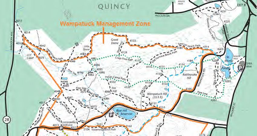
Division of Fisheries and Wildlife (DFW) to conduct a study of white-tailed deer populations within the Blue Hills
Reservation and to ascertain the extent of their impacts on the Reservation’s natural resources.” In addition,
the RMP recommended that, if warranted, discussions regarding deer management options should take
place.4

In addition to these environmental and ecological threats, the agency, along with a variety of local
stakeholders – including the Friends of the Blue Hills Reservation 5 and nearby neighbors – have recognized
increasing public health/safety concerns posed by an overabundance of deer in the Blue Hills. Specifically, deer-
vehicle collisions in the area as well as the contraction of Lyme disease and other tick-borne illnesses by
neighbors and visitors have been noted as significant and emerging community concerns.

The decision to manage the overpopulation of deer in the Blue Hills Reservation, however, is not dependent
upon perceptions regarding the role of deer in relation to Lyme disease or other tick-borne illnesses. DCR
recognizes the myriad of research that has demonstrated mixed results over the last several decades with
regard to the correlation between deer densities, tick abundance, and Lyme disease contraction rates among
humans. Furthermore, attempting to solve Lyme disease or reduce contraction rates is not a primary goal of
DCR’s deer management plan for the Blue Hills. Rather, as stewards of the Blue Hills Reservation, DCR has a
legislative mandate and a mission to maintain or restore ecologically healthy ecosystems and habitats. Forests
that contain an overpopulation of deer are subjected to considerable over-browse of vegetation and
significant negative impacts on ecological diversity and long-term forest health. The role of persistent high
deer densities in producing these types of negative impacts is already evident in the Blue Hills. By initiating a
deer management program, it is DCR’s objective to reduce (and in the long-term reverse) these negative
impacts, to bring deer densities to a level more aligned with what the forest can sustain, and to promote the
restoration of native vegetation and healthy habitat for other wildlife.

To understand how this problem has emerged in the Blue Hills Reservation requires an understanding of the
property’s history and land management. Like many forested areas in New England throughout the 18 th and
19th centuries, many areas of the Blue Hills were cleared by pre- and post-Colonial inhabitants for firewood
and/or conversion to farmland. In fact, the deforestation of the Blue Hills area began in the late 17 th century to
supply lumber merchants and shipbuilders with large timber. As a result, suitable habitat for white-tailed deer
was considerably reduced. In addition to this reduction in suitable habitat, unregulated hunting of deer as a
source of food also took place at all times of the year.

In the late 19th and early 20th centuries, however, farming in the Blue Hills became less profitable and
industrialization and the growth of manufacturing pushed many people and families toward cities, resulting in
the abandonment of farms and changes in the landscape through natural succession back to forests. T his
conversion over several decades back to forestland resulted in improved deer habitat and an increased
carrying capacity in the area to support growing deer populations.

With the extirpation of major historic predators (mountain lions and wolves), deer populations are capable of
growing exponentially, even with mortality from current predators (coyotes, black bears, and bobcats) and
deer-vehicle collisions. Humans are the only remaining major predator able to control deer populations. Where
there is adequate access, regulated hunting is able to keep deer numbers in balance with the habitat. However,
hunting has become increasingly difficult in many areas of eastern Massachusetts. Since the 1920s, stricter
hunting regulations, such as municipal bans on the discharge of firearms or restrictions on the distance from
homes and roadways in which firearms may be discharged (MGL Ch. 131, § 58), have created sanctuary habitat
favoring deer population increases. These circumstances have also served as contributing factors to deer

4
    Ibid, p. 116, http://www.mass.gov/eea/docs/dcr/stewardship/rmp/bh/sections1-4.pdf.
5
    The Friends of the Blue Hills is a non-profit organization that works both independently and in cooperation with the DCR to preserve the
    natural resources of and enhance recreational opportunities in the Blue Hills Reservation. Many of its leaders and members include
    individuals who live, work, and own property in the communities where the Reservation is located and, in some cases, directly adjacent to
    the boundaries of the Reservation.

                                                                                                                                                5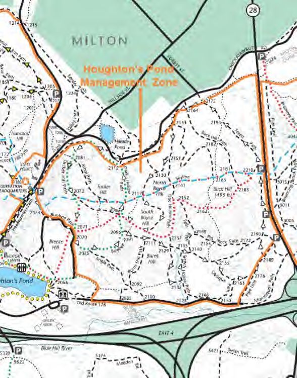
overabundance concerns in the Blue Hills Reservation since its acquisition by the Metropolitan Park
Commission.

The acquisition of the Blue Hills Reservation signified an important change in land use for that property. Aside
from the many ecological implications on wildlife, vegetation, and habitat throughout the Reservation,
management of the Blue Hills for public enjoyment and recreation also limited opportunities for legal hunting
within the Reservation. In general, hunting within state parks, forests, and Reservations, as well as other public
lands, is governed by Section 59 of Chapter 131 of the Massachusetts General Laws (MGL Ch. 131, §59). This
section of state law expressly prohibits the hunting of any bird or mamm al on any state Reservation, park, or
common; or land held in trust for public use; without the permission of the authority controlling the property
and only during the appropriate open season for the animal to be hunted. MGL Ch. 131, §59, however, does
exempt state parks and Reservations under the control of the former Department of Environmental
Management (DEM), which was one of DCR’s predecessor agencies.

As one of the properties acquired by the Metropolitan Park Commission, however, the Blue Hills Re servation
went on to be managed by the Metropolitan District Commission (MDC) – DCR’s other predecessor agency.
Under the MDC, the authority of its Commissioner to make rules and regulations for the management of the
MDC’s properties was codified in MGL Ch. 92, §37 and, pursuant to this authority, regulations governing use of
former MDC reservations were promulgated in 350 CMR 2.00 (“Use of Reservations and Parkways”). In terms
of hunting, the rules in the Blue Hills (as was the case in nearly all former MDC properties) prohibited hunting
or trapping of animals unless authorized by law or the Commissioner. 6

All of these factors – development of prime deer habitat following abandonment of farms, suburbanization,
displacement of predators, and restrictions on legal hunting – have therefore contributed over time to the
establishment of favorable conditions allowing the deer population in the Blue Hills to grow to high levels. In
fact, over the last few decades the only serious contributor to deer mortality in and around the Blue Hills –
aside from natural causes – has been vehicle collisions and extremely limited and controlled archery hunting on
certain private properties adjacent to the Reservation.

1.3 Deer Abundance Surveying in the Blue Hills
In early May of 2013, DCR worked
collaboratively with DFW to conduct a
white-tailed deer abundance survey in the
Blue Hills Reservation at the request of the
Friends of the Blue Hills. The goal of the
survey was to estimate (using quantitative
methods) the density of deer per square
mile within the Reservation. Using distance
sampling as a survey method, two crews of
DFW and DCR staff gathered observations
and data over the course of three nights
for approximately four to six hours each
night. The survey was conducted along a
representative sample of available roads
and trails within and around the Blue Hills
Reservation and 14 survey routes (or
transects) of similar lengths were
identified. Both paved roads and dirt trails

6
    On October 24, 2014, former MDC regulations contained in 350 CMR 2.00 were official rescinded and replaced by 302 CMR 12.00, which
    contain parks and recreation rules for all DCR properties. With regard to hunting in the Blue Hills, applicable regulations in 302 CRM 12.00
    remain the same as those previously contained in 350 CRM 2.00.

                                                                                                                                                   6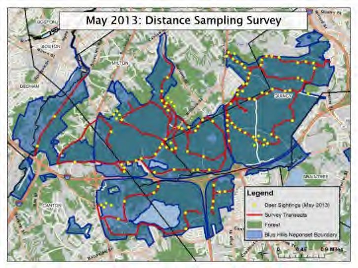
in areas considered deer habitat were used (see map below). As such, about 80 percent of the study area was
forested and/or shrubland and considered to be deer habitat.

Following the physical collection of data, DFW staff performed statistical analyses of the information using
several models and methods. Based upon the results of this analysis, DFW estimated (conservatively) that
there are about 85 deer per square mile of deer habitat in the Blue Hills. It is important to reiterate that this
density estimate is believed to be conservative and that the actual deer population density is likely higher.7 For
additional details regarding the population survey and data analysis, readers are strongly encouraged to review
DFW's technical report developed and published by David P. Stainbrook, DFW Deer and Moose Project Leader .8

Given the results of the population survey and the density estimates produced, it is very clear that deer
densities in the Blue Hills are well above DFW's statewide deer management range of 6 to 18 deer per square
mile of forest. In addition, DFW’s technical report also noted (citing Tilghman 1989,9 and Horsley, et al., 200310)
that this density estimate for the Blue Hills exceeds the threshold density of 18 to 20 deer per square mile of
forest where negative impacts become evident in northeastern forests.

1.4 Deer Management Planning Efforts
As steward of the Blue Hills Reservation, DCR has become increasingly concerned with the long -term health of
the forestland within the Reservation and the ecological impacts of unfettered growth in the white-tailed deer
population. The results of the population density survey substantiate long-held perceptions and anecdotal
observations that the deer population within the Reservation has grown to become considerably large.

On June 18, 2014, the Friends of the Blue Hills hosted a public meeting at the Trailside Museum in Milton where
staff from DFW presented the population survey findings. Many who attended were local resident s and
neighbors of the Reservation and most did not express extreme surprise with the survey results given their
experience and observations. Additionally, the vast majority of those in attendance also expressed strong
support and a desire for the DCR to move toward taking action that could alleviate the problem. During the
meeting, DCR informed attendees that the agency would work closely with DFW to begin careful planning
around potential deer management options within the Blue Hills.

Efforts around deer management planning in the Blue Hills have also been encouraged as a result of two other
developments. The first involves the DCR’s consolidation of park regulations that pertained to and were
previously promulgated under the former MDC and DEM. This effort entered the public domain in the fall of
2013 and as part of the public process, DCR received considerable comment in support of opening areas
currently closed to hunting. Although the final set of park regulations promulgated on October 24, 2014, did
not include revisions that would have opened DCR properties previously closed to hunting, the agency pledged
to work with DFW to conduct further analysis of these areas to determine if they could be opened in the future
to deer hunting.

The second important development involves a legislative mandate in the 2014 Environmental Bond Bill
(Chapter 286 of the Acts of 2014), which was approved in August 2014. Specifically, Section 43 of the bond bill
directs DCR (in consultation with DFW) to “identify areas in which deer overpopulation is negatively impacting
forestation, water resources or plant growth on department-owned land” and “to develop and implement a
harvest management plan for the identified areas.”

7
    David P. Stainbrook, Estimating White-tailed Deer Abundance at the Blue Hills Reservation using Distance Sampling (Massachusetts Division
    of Fisheries and Wildlife, November 2013), http://www.mass.gov/eea/docs/dcr/parks/south/blue-hills-deer-survey-report.pdf.
8
     http://www.mass.gov/eea/docs/dcr/parks/south/blue-hills-deer-survey-report.pdf
9
     N.G. Tilghman, Impacts of White-Tailed Deer on Forest Regeneration in Northwestern Pennsylvania (Journal of Wildlife Management, 1989)
     53: 524-532.
10
      S.B. Horsley, et al., White-tailed Deer Impacts on the Vegetation Dynamics of a Northern Hardwood Forest (Ecological Applications, 2003)
     13: 98-118.

                                                                                                                                                 7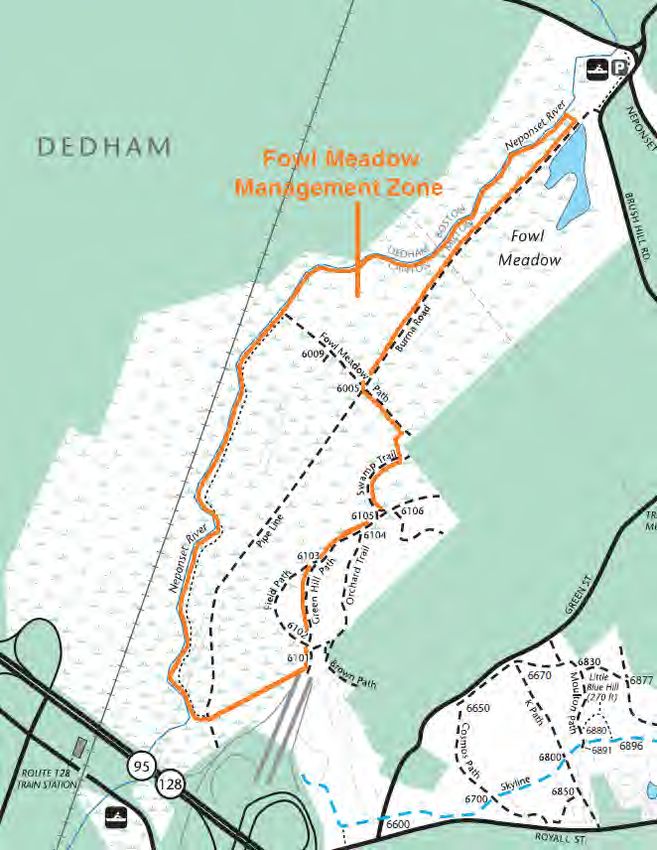
Following the analysis of population survey data, staff from DCR and DFW began working together over the
course of several months to assess deer management options within the B lue Hills Reservation. Both agencies
recognize that management activities can take several forms and that the measures implemented can have
varying degrees of efficacy while presenting different challenges.

2.0 Overview of Alternative Deer Management Approaches

2.1 No Action
If nothing is done to control deer densities in the Blue Hills Reservation, the local deer population will likely
continue to increase. In the absence of major historic predators such as mountain lions and wolves, deer
populations have little natural mortality factors to keep their populations in balance with what their habitat can
support. Mortality from current predators (coyotes, bobcats, black bears, etc.) has been documented to lead
to approximately 20% to 40% of the fawn population to die each year, but account for less than 1% to 5% of adult
mortality.11 Even with other sources of mortality, such as vehicle collisions, the deer population will continue to
grow. The continued population growth will lead to increased vehicle collisions and other public safety issues,
increased impacts to the forest, and decreased health of the deer. Fencing and repellents may minimize
impacts to certain areas or plants, but the other issues of deer overabundance are still present.

2.2 Non-Lethal Action
Contraception: Technology and advances in contraceptives have come a long way over the last 20 years, such
that there are options that have worked well with feral horses, captive and zoo animals, and wildlife in a closed
setting. However, these options have not yet been shown to be effective at r educing high deer densities in
open systems of free-ranging populations. If all females in a completely closed system (such as an island or a
fenced-in area) were treated, the population would theoretically drop as deer die of old age or get hit by
vehicles, but adult female survival rates in Massachusetts are quite high and deer can survive a long time (e.g.,
over 15 to 20 years documented from studies in MA).12

Sterilization: Complete sterilization (reproductive organs of the female are removed) has been shown to be
more effective at preventing pregnancy than other contraceptive methods. However, even if every female in
the population was treated, without physically removing deer, the population will not drop in a reason able
amount of time if at all; rather, it will only prevent or slow growth.

In 2007, Cornell University undertook a deer management program on university-0wned lands in the Town of
Ithaca, New York, to deal with population densities that exceed 50 deer/mi 2. The program started out with the
use of surgical sterilization (tubal ligation and ovariectomy) at a cost of approximately $1,000 per deer. By 2013,
researchers noted that “it became clear that we only stabilized the deer population, and did not reduce
numbers to a level that alleviated negative impacts.” 13 After about six years of implementing the program, the
deer herd at Cornell was estimated to be approximately 57 deer/mi 2; an estimate that remained much higher
than the density goal of about 14 deer/mi 2 that they hoped to achieve.

11
     J.K. Vreeland, et. al., Survival Rates, Mortality Causes, and Habitats of Pennsylvania White-Tailed Deer Fawns (Wildlife Society Bulletin, 2004)
     32(2): 542-553.
12
   J.E. McDonald, Jr., et. al., Survival and Harvest-Related Mortality of White-Tailed Deer in Massachusetts (Wildlife Society Bulletin, 2011)
   35(3): 209-219.
13
   J.R. Boulanger, et. al., An Integrated Approach for Managing White-Tailed Deer in Suburban Environments: The Cornell University Study
   (Cornell University Cooperative Extension and Northeast Wildlife Damage Research and Outreach Cooperative, 2014): 21,
   http://wildlifecontrol.info/deer/Documents/IDRM%2012-11-14%20Final.pdf.

                                                                                                                                                        8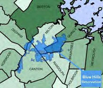
By 2014, the continued high deer densities led researches to discontinue all forms of surgical sterilization
altogether and their experience led to the following conclusion:

       Results from theoretical studies and the Cornell experience do not bode well for the feasibility of surgical
       sterilization as the sole tool for reducing high-density, open deer populations. We recognize that local
       housing densities and lack of open space present real challenges for managing deer in suburban and
       urban areas, and social pressures against lethal control may direct communities toward sterilization or
       other fertility control programs... Nonetheless, communities considering, or being forced into a
       sterilization program by opponents of deer removal, should be prepared to only achieve small reductions
       in deer numbers. In this scenario, a high proportion of females would need to be treated, and deer
       mortality from [deer-vehicle collisions] should offset births and immigration. However, they may not see
       long-term success, even over 10 years or more, unless [deer] immigration can be controlled, or deer
       mortality can be increased… We see little hope for long-term viability of this strategy. Those
       communities that started with sterilization only, have subsequently either embraced let hal deer
       management, or allowed deer populations to persist at undesirable levels. 14

After abandoning sterilization methods, Cornell revised its deer management program to focus on expanded
use of controlled hunting in the form of both archery and firearms.

Trap and Transfer: Moving deer from the Blue Hills Reservation to other areas would not be a realistic option.
It is an expensive and complex operation. There are no feasible release sites in need of more deer , and the
transfer of wildlife is illegal in Massachusetts. Also, the translocation process is stressful on deer and can lead
to increased disease spread.

2.3 Lethal Action
Trap and Euthanize: Trapping and euthanizing deer is a complex and expensive operation, which is also not a
realistic or feasible option in Massachusetts. It is controversial and contradicts the North American Model of
Wildlife Conservation by denying citizens access to a public renewable resource.

Commercial Removal: Hired shooting can be effective at reducing deer populations, but can be expensive,
especially at a large scale. It is also controversial and contradicts the North American Model of Wildlife
Conservation by denying citizens access to a public renewable resource. Currently, DFW only allows h ired
shooting to take place at airports for public safety reasons.

Hunting: Legal, regulated hunting by licensed hunters using a variety of hunting implements (e.g., shotgun,
archery, and primitive firearms), has been used in the Commonwealth to effectively and safely manage deer
populations. In Massachusetts, deer hunting is allowed each year from the middle of October through the end
of December. The archery season begins in the middle of October and runs for six weeks. The shotgun season
begins on the Monday after Thanksgiving and lasts two weeks. In addition, the season for primitive firearms
(“muzzleloaders”) begins around the middle of December (following the end of shotgun season) and ends on
December 31. Archery methods may be used during all three seasons, and primitive firearms may be used
during the shotgun season.

To effectuate successful deer management, land needs to be open to hunting. If property owners (whether
private or public) decide to place additional restrictions on legal hunting, such as limiting the number of
hunters or the areas in which hunting is allowed, it is considered a controlled hunt, but these restrictions can
often lead to decreased effectiveness at reducing deer numbers.

14
     Ibid.

                                                                                                                      9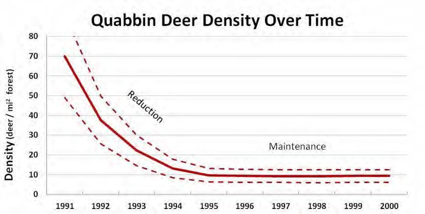
1)   Archery Hunting: Restricting the hunting implements to archery methods may be more desirable for
     communities not accustomed to hunting. However, archery hunting alone during a reduction phase
     may not result in an adequate number of deer being harvested in a reasonable time frame; particularly
     in light of the extremely high densities currently in the Blue Hills Reservation. Archery hunting provides
     limited harvest because of the limited range to their target (typically within 20-30 yards) and the time
     required to have a deer come within range of a hunter’s tree stand and present an acceptable target.

     In terms of deer densities, the chart below predicts the potential range of population densities over
     the course of a decade using an archery-only approach over the course of over 8 weeks of archery
     hunting each year. The model starts at 85 deer per square mile (as estimated during the May 2013
     survey) and shows a projection (solid line) of deer density over that time (assuming less than a 20%
     harvest rate), along with relative confidence (dotted lines) surrounding that projection over time.

                                               Projected Reduction with > 8 weeks of Archery Hunting Only
                                      100
                                       90
                                       80
              Density (deer / mi2 forest)

                                       70
                                       60
                                       50
                                       40
                                       30
                                       20
                                       10
                                        0
                                            Year 1   Year 2   Year 3   Year 4   Year 5    Year 6   Year 7       Year 8   Year 9

                                                 Source: Massachusetts Division of Fisheries & Wildlife (DFW)

2)   Firearms Hunting: Hunting with firearms is sometimes perceived as unsafe in communities and among
     members of the public who are not used to or have not experienced this form of activity. However,
     hunting with firearms has been used safely in Massachusetts for a very long time and is extremely
     effective in harvesting deer within a very short hunting season. In Massachusetts, firearms include
     shotguns (which are only allowed for two weeks around the beginning of December) or primitive
     firearms, such as “muzzleloaders.”

     In terms of deer densities, the following two charts predict the potential range of population densities
     over the course of a decade utilizing a shorter and a longer shotgun season. Once again, the model
     starts at 85 deer per square mile. Within a five-year reduction phase, it is estimated that deer densities
     could be reduced to below approximately 50 deer per square mile of forest if fewer than 5 days of
     firearms hunting are used and reduced to below approximately 20 deer per square mile of forest if
     more than 8 days of firearms hunting are used. The solid line shows the projected reduction and the
     dotted lines show the relative confidence surrounding the projection. If the reduction phase is
     successful at achieving densities of less than 20 deer per square mile, this would allow for forest health
     and better align with DFW’s statewide management ranges, which range from 6 to 18 deer per square
     mile of habitat.

                                                                                                                                  10
Projected Reduction with 3-5 days of Shotgun Hunting Only
100
90
80
Density (deer / mi2 forest)
70
60
50
40
30
20
10
0
Year 1 Year 2 Year 3 Year 4 Year 5 Year 6 Year 7 Year 8 Year 9
Source: Massachusetts Division of Fisheries & Wildlife (DFW)
Projected Reduction with 6-10 days of Shotgun Hunting Only
100
90
80
Density (deer / mi2 forest)
70
60
50
40
30
20
10
0
Year 1 Year 2 Year 3 Year 4 Year 5 Year 6 Year 7 Year 8 Year 9
Source: Massachusetts Division of Fisheries & Wildlife (DFW)
3.0 Deer Impact Management for the Blue Hills Reservation
Addressing the long-term ecological, public health, and public safety concerns associated with an
overabundant deer population in the Blue Hills Reservation is an important objective for which several
management options are available. Given the outcome of the May 2013 deer density survey and anecdotal deer
browse impacts noted in the Reservation, DCR has determined that these factors are negatively impacting the
agency’s ability to properly meet its mission to protect, promote, and enhance the natural resources of the
Blue Hills Reservation for the enjoyment and appreciation of current and future generations.
While “no action” has been listed among the management options, DCR and DFW agree that following such a
course will not restore the ecological health of and biodiversity within the Blue Hills Reservation. In the
absence of any form of intervention and population control measures, deer densities within the Reservation
will likely continue to grow. Moreover, unrestricted and persistent over-browsing of the Reservation’s
vegetation will continue and will lead to further negative impacts and consequences to the long-term viability
of the forest.
113.1 Recommended Deer Management Option
DCR and DFW concur and have concluded that the most practical and effective management option to
accomplish the objective of addressing deer overabundance in the Blue Hills Reservation is through the use of
regulated hunting in the form of a controlled hunt. As an overarching management strategy, however, DCR
and DFW also recognized that a controlled hunt can be designed and implemented in a variety of ways.
Specifically, provisions regarding the timing and duration of the hunt and hunting implements allowed can be
adapted within a harvest management plan to take into consideration the objectives of the management
program and the potential impacts.
For example, if opened to hunting, this opportunity would likely lead to considerable interest from hunters.
Therefore, DFW has recommended that limitations be placed upon the number of hunters that can participate
in order to provide a safe hunting environment, avoid overcrowding of hunters, and prevent over-pressuring
deer, which may lead to decreased harvest.
DFW has cautioned, however, that the imposition of too many restrictions, such as decreasing the hunting
season length or restricting the types of hunting implements allowed, may ultimately hinder the ability of a
controlled hunt to reduce deer numbers in a reasonable amount of time. Moreover, DFW has recommended
that this balance be taken into consideration, especially in the first few years of the hunt (the reduction phase)
where harvest rates need to be sufficiently high to drop deer densities adequately. Once deer numbers are
lowered to a more suitable level, DFW has suggested that additional restrictions could be added during the
subsequent maintenance phase.
DFW's Recommended Management Action
100
80
Density (deer / mi2 forest)
Reduction Phase
60
40
Maintenance Phase
20
DFW Sta tewide Ma nagement Ranges (6-18 deer/mi2 forest)
0
2015 2016 2017 2018 2019 2020 2021 2022 2023
In terms of controlled hunts, there have been several successful models in Massachusetts and DCR need not
look any further than its own annual controlled hunt on Quabbin Reservation, which is organized, managed,
and implemented by DCR’s Division of Water Supply Protection (DWSP). Moreover, a controlled hunt at the
Blue Hills would not be ground-breaking and new, especially for DCR.
The annual controlled deer hunt at DCR’s Quabbin Reservoir Watershed is a prime example of a similar
situation in which extremely high deer densities that threatened the long-term viability of the watershed forest
and water quality needed to be (and have been) successfully reduced and maintained. The Blue Hills
Reservation is in a much different setting than the Quabbin, but they are actually quite similar from a deer
management standpoint. The Blue Hills is over 80 percent forested and more than 75 percent of the deer
habitat within the Reservation is outside of the state discharge setbacks, which allows deer reduction efforts
to be more effective. The chart below shows deer densities over time at the Quabbin Reservoir Watershed
since initiation of the annual controlled deer hunt in 1991. The Quabbin hunt only allows firearms, and in the
first year of the hunt it took place over the course of nine days during the statewide shotgun season. Within a
few years, deer densities were substantially reduced and the program moved from a reduction phase to a
maintenance phase. As a part of this maintenance phase, the hunt now only takes place over the course of four
days during the two-week shotgun season.
12Source: Massachusetts Division of Fisheries & Wildlife (DFW)
Further, lack of hunter effort should not be a factor in the Blue Hills Reservation, as hunters in Massachusetts
have routinely put in effort to hunt in areas with low deer density. Over 22,000 hunters live within a 30-mile
radius of the Reservation and huntable lands in the east are in high demand. There is still demand from hunters
to gain access to hunt in the Quabbin, even with current deer densities below 15 deer/mi 2 and plenty of
huntable land nearby.
3.2 Rationale and Objectives for Deer Management in the Blue Hills Reservation
In deciding to undertake a deer management program in the Blue Hills Reservation, the primary objective and
rationale for intervening is to maintain an ecologically sustainable deer density that allows for the continuous
growth and development of forest regeneration. In particular, DCR wishes to reduce the negative impacts high
deer densities have on the regenerating forest to ensure a healthy forest composed of adequate diversity of
species and age classes. Moreover, the management plan outlined in this document is not intended to provide
a new recreational opportunity at the Blue Hills. Rather, the plan provides a concrete, practical, and workable
solution intended to deal with a critical environmental problem.
4.0 Proposed Blue Hills Reservation Controlled Hunt Program
As DCR has learned from its experience implementing a controlled hunt at Quabbin, managing deer
populations is a complex and dynamic process that is shaped and influenced by a variety of interdependent
factors related to deer population size and control. Some of these factors include weather conditions,
reproductive success, and non-hunting mortality. As a result, DCR recognizes that effective deer management
programs must provide and maintain a good degree of flexibility to modify a management plan based u pon
experience and ongoing assessment.
The use of licensed public hunters in managing deer populations is one of the most widely used management
methods employed throughout the United States. In Massachusetts, it is the primary management tool
supported by DFW and has been shown to be successful in addressing situations involving deer overabundance
and vegetation over-browse. The Quabbin Reservoir Watershed is the most notable example. In addition, DCR
manages thousands of acres of forest and parkland across the Commonwealth where licensed hunters are
allowed to hunt game during the appropriate seasons. Moreover, hunting is an activity that DCR fully supports
by providing public land for hunters to engage in this management activity.
13While there may be some members of the public who are opposed to the use of regulated hunting to manage
deer populations, DCR and DFW believe that this option is the most practical, cost-effective, and efficient
management option that could be applied to a property as large as the Blue Hills Reservation. In coming to
this conclusion and in developing a plan for a controlled hunt in the Blue Hills, DCR and DFW utilized several
filters and considerations. Among these were public safety, resources, efficacy (in terms of reducing deer
densities in a reasonable amount of time), and timing (both from the perspective of how long it might take to
reach a more sustainable deer density and also the duration of time in which hunting would actually take place
within the Reservation). DCR also recognizes that each of these considerations impact the others. For example,
decisions regarding timing affect efficacy as well as the resources needed to oversee and manage the
controlled hunt.
As a result, and given that the introduction of legal hunting in the Blue Hills would represent a considerable
change in the management of the property, DCR believes that a new program such as this should be
introduced as a pilot and implemented initially on a more limited scale with a long-term goal of expanding the
program to the appropriate level in order to effectuate successful reduction of the deer population . The
Department also understands that steadfast support and a long-term commitment to deer management from
the community and local stakeholders is a vital element. Moreover, DCR is inclined in the initial years to
prioritize other considerations over efficacy in order to ensure both the short- and long-term success of a deer
management program in the Blue Hills. The plan that is outlined in this document follows this approach.
4.1 Controlled Hunt Program Components
Participation & Access Permitting: As noted previously, the Blue Hills Reservation has been closed to legal
hunting for a very long time and harbors a high density of white-tailed deer. As a result, DFW and DCR
anticipate considerable interest among hunters in participating in a hunt in the Blue Hills. Therefore, i n a
manner similar to the controlled hunt at DCR’s Quabbin Reservation, the Blue Hills controlled hunt will feature
an access permitting component whereby interested hunters will need to complete and submit an application
packet to DCR in order to participate in the Blue Hills hunt. Applicants must have a valid FID card and hunting
license in order to participate. Given the size of the Reservation, permit applications will be for individual
hunters and not for groups of hunters. Using a random lottery system (similar to the system used by DWSP for
Quabbin) permitees will be selected from among licensed hunters who have completed and signed a DCR
application packet. At this time, DCR will not charge an application fee for permits to the Blue Hills Reservation
controlled hunt program. In future years, however, DCR may consider the establishment of a nominal
application fee as part of the application process.
Hunter Orientation: As is the case with DCR’s Quabbin Reservation controlled hunt, all permittees will be
required to attend an orientation session organized and hosted by DCR and its partner agencies. Among other
topics, the orientation will cover: the elements of the Blue Hills deer management plan; the goals and
objectives of the program; an orientation to the area; safety considerations; and area assignments. Upon
selection into the controlled hunt program, permitees will be assigned to an orientation session at a given time
and location. Non-attendance of this orientation will automatically result in a permittee’s removal from the
program. Given DCR’s plan for a phased implementation involving modifications to the logistics of the
controlled hunt (outlined below), permittees will be required to attend the orientation session annually at least
for the first 4 or 5 years of the program. Thereafter, DCR will assess future orientation needs and
publish/communicate attendance requirements for new and returning permittees.
Antlerless Permits: Antlerless deer permits specific to the Blue Hills Reservation controlled hunt will be
available annually to applicants that are selected for an access permit. Once informed of selection, successful
applicants will be able to purchase their permits online, or at any license vendor. During the initial years
(reduction phase), hunters must purchase two antlerless permits and be willing to take an antlerless deer to
participate in the management hunt.
14Check-in / Check-out Procedures: The Blue Hills controlled hunt will require all permittees to check-in and
check-out of the Reservation each day that they hunt. A check-in station will be established at the visitor’s
center at Houghton’s Pond Recreation Area. Check-in time shall be between 5:00 and 7:00 AM and check-out
time shall be no later than 4:00 PM given the general time for sunset in early December.
Roadway Restrictions: On those days in which hunting is taking place in the Reservation, DCR will institute a
closure of Chickatawbut Road (from Route 28/Randolph Avenue to Route 37) similar to the closure that is
implemented on Sundays. In addition, DCR will also close Wompatuck Road (from Chickatawbut Road to Route
37) to regular vehicular traffic. Road closures will be in effect each day of the controlled hunt until 5:oo PM.
After checking in, permitted hunters will be allowed access onto Chickatawbut Road and Wompatuck Road
and will be allowed to park along these roads while hunting. DCR will work with other state and local agencies
to announce (via the web, press/media, social media, etc.) the road closure in advance and to provide
information regarding detours. In addition, DCR will post variable message boards at appropriate locations in
advance of the hunt to announce road closures.
Vehicular Access and Parking: Permitted hunters will not be allowed to park along the sides of I-93. In addition,
vehicular access will be prohibited on the Reservation’s trails. Hunters with a valid access permit will be
allowed to park along Chickatawbut Road and Wompatuck Road while hunting. In addition, parking will be
allowed in the following locations:
Houghton’s Pond parking lot on Hillside Street
Site 5/Ballfields parking lots on Blue Hill River Road
Pull-off parking areas along Route 28
Park & Ride parking lot on Route 138
Paul’s Bridge parking area in Fowl Meadow
End of Royal Street (abutting Fowl Meadow)
North parking lot at Trailside Museum
Hancock Hill off of Unquity Road
Corner of Chickatawbut Road and Route 28
During orientation sessions, DCR will provide permittees with maps identifying these parking areas.
Deer Cleaning and Checking: Permitees who harvest a deer are required to move the deer at least 100 feet
away from a trail for the purposes of gutting and cleaning the deer. Hunters who harvest a deer are
responsible for transporting the deer to their vehicle and all harvested deer must be taken to the deer check
station to be officially sealed.
Hunter Distribution & Management Zones: In order to organize and distribute hunters effectively and avoid
heavy concentrations of hunters in one area of the Reservation, the Blue Hills will be sub-divided into several
management zones. The number of hunters permitted within each zone will be based upon the size of the area
at a ratio of 1 hunter per 30 acres. Permittees will receive their zone assignments upon issuance of an access
permit. Once assigned, permitees will be required to stay within their assigned zone while hunting. See the
below section titled Year 1 Program Components for more details regarding hunter distribution and
management zones during Year 1 of the controlled hunt.
Scouting: Permitted hunters will be allowed to scout the Reservation prior to the controlled hunt. Any hunter
who is scouting within the Blue Hills must carry on their person their hunter identification and the letter they
receive from DCR indicating that they have been selected to participate in the controlled hunt. Scouting will
not be allowed on those days in which the controlled hunt is actually taking place.
Tree Stands: DCR is encouraging selected permittees who are comfortable with this form of hunting to make
use of tree stands while participating in the controlled hunt. As such, permitted hunters will be allowed to
install tree stands beginning one week before the first day of the controlled hunt. All tree stands must be
15removed within five days of hunting. The installation of a tree stand does not entitle a hunter to a particular
area of the Reservation. Hunters possessing a permit to hunt in a particular management zone may hunt in any
area within the boundaries of that zone. In accordance with DCR’s regulation at 302 CMR 12.11 (10), the
installation of a permanent tree stand will not be allowed. Permanent tree stands are defined as a type of
hunting platform or structure (emplaced for any period of time) which is fastened to a tree by nails, bolts, wire,
or other fasteners which intrude through the bark into the wood of the tree.
Violations: Any violation of the rules of this controlled hunt program will result in the immediate removal from
the property and suspension of access to the Blue Hills Reservation hunt in future years. In addition, any
person found to be hunting within the Reservation without a valid access permit will be immediately removed
from the property, will be prohibited from applying to participate in the controlled hunt in future years, and
may be subject to any fines or penalties prescribed by applicable state laws and/or regulations.
Public Information, Outreach, & Signage: In advance of the controlled hunt, DCR will work with other state
and local agencies and the Friends of the Blue Hills to ensure the public and neighbors are informed of when
and where the hunt will take place. This includes issuing press releases, posting information on websites and
via social media outlets, placement of variable message boards at key park e ntrances and intersections,
delivering informational flyers/notices to neighbors, and hosting a public information session in advance of the
hunt. DCR will also post appropriate signage at trailheads and on all bulletin boards and informational kiosks
(before and during the hunt) to inform the public of the hunt. Informational flyers and notices and any
postings on websites or social media will also include contact information for the public to report any concerns
or ask questions while the hunt is taking place.
Phased Implementation: Implementation of a controlled hunt in the Blue Hills Reservation will occur in a
phased manner. Although many similar situations involving high deer densities resulted in the development of
harvest management plans that featured an aggressive reduction phase in the initial years (including the
Quabbin Reservation), given the novelty of hunting in the Blue Hills, DCR has decided to initially implement a
controlled hunt on a more limited scale while working toward the goal of expanding the program in order to
achieve a more aggressive reduction phase in future years. Table 1 and the sections that follow outline the
phased implementation envisioned by DCR over the course a ten-year period and beyond. It is important to
note, however, that this plan may be subject to change and modification based upon ongoing assessment of
the program’s implementation each year. Therefore, while program components are outlined in greater detail
for Year 1, program components for all subsequent years are merely proposed and may be subject to further
modification following an assessment of Year 1.
Table 1: Phased Implementation Plan for Blue Hills Controlled Hunt
Segment* Hunting Dates Allowable Areas
Year 1 1 Monday & Tuesday
North of I-93
(2015) 2 Monday & Tuesday
PROPOSED 1 Monday & Tuesday North of I-93
PROPOSED · PROPOSED
Year 2
(2016) 2 Monday & Tuesday South of I-93
PROPOSED 1 Monday through Wednesday North of I-93
Year 3 -9
(2017-2023) 2 Monday through Wednesday South of I-93
PROPOSED
Year 10+ Similar to Year 2
(2024+)
* Segment 1 refers to the days within the first week of shotgun season and Segment 2 refers to days within the second week of shotgun season.
164.2 Year 1 Program Components
Timing & Length: The timeframe for the controlled hunt will be during the annual shotgun season in late
November/early December. Although the shotgun season in Massachusetts begins on the Monday after
Thanksgiving and lasts two weeks, Year 1 of the Blue Hills controlled hunt will have a total of four days of
hunting. These four days will be separated into two, two-day segments that include the Monday and Tuesday
of each week during the shotgun season. Therefore, there will be no hunting in the Reservation in Year 1 from
Wednesday through Sunday.
Hunter Distribution & Management Zones: In Year 1, hunting will only be allowed in designated areas of the
Reservation located north of I-93. In addition, hunting will be allowed in areas east of the Neponset River in
Fowl Meadow. In subsequent years, it will be DCR’s goal to expand hunting to other areas of the Reservation;
including those areas south of I-93.
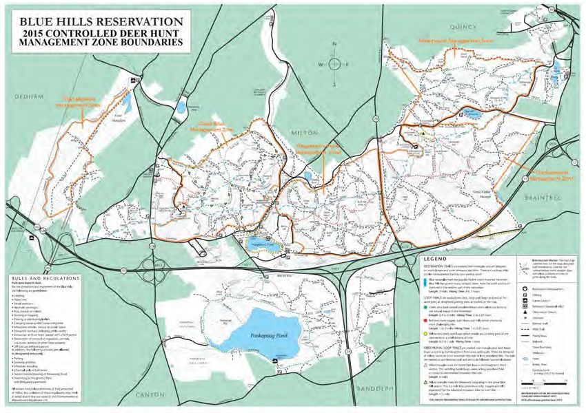
The designated areas have been divided into five management zones. Figure 1 identifies each of the five zones
using the following names: Fowl Meadow (248 acres), Great Blue (637 acres), Houghton’s Pond (575 acres),
Chickatawbut (1,020 acres), and Wompatuck (496 acres). Based upon the acreage in each zone and a hunter
distribution system of 1 hunter per 30 acres, each of these management zones will have the capacity to
accommodate the following number of hunters per day:
Fowl Meadow (248 acres): 8 hunters
Great Blue (637 acres): 21 hunters
Houghton’s Pond (575 acres): 19 hunters
Chickatawbut (1,024 acres): 34 hunters
Wompatuck (496 acres): 16 hunters
As such, no more than 98 access permits will be issued per two-day segment, which means that no more than
98 hunters will be allowed to participate at any given time during the controlled hunt.
Figure 1: Year 1 Management Zones & Acreage
17Access: As noted previously, hunting will only be allowed in designated areas of the Reservation located north
of I-93 during Year 1. The boundaries of the five management zones have been established using not only the
existing state setback laws and regulations, but also hard boundary delineations, such as trails, roads, and
pathways that can be easily identified on the ground. In many cases, the boundaries that have been delineated
exceed the existing statutory discharge setback standards of 150-feet from a hard-surfaced highway and 500-
feet from a dwelling in use. Figures 2 through 7 below show trail maps of each of the five management zones
and the outline the boundary delineations that that been established and will be communicated with
permittees.
Figure 2: Blue Hills Reservation Management Zone Boundary Delineations
18Figure 3: Fowl Meadow Management Zone Figure 4: Great Blue Management Zone
Figure 5: Houghton’s Pond Management Zone
19Figure 6: Chickatawbut Management Zone
Figure 7: Wompatuck Management Zone
20Participation: In Year 1, each permittee will be allowed to hunt during one of the two-day segments. As such,
each hunter may hunt for up to 2 days and will be issued an access permit for each day that they hunt.
Hunting Implements: In Year 1, participants will be allowed to use shotguns with slugs only. Buckshot shall be
prohibited from use in the Blue Hills. The potential use of archery hunting in future years may be considered.
Unified Command & Staffing: The successful implementation of this deer management program for the Blue
Hills will involve close inter-agency coordination among DCR, DFW, the Massachusetts Environmental Police
(MEP), the Massachusetts State Police (MSP), and local law enforcement agencies from the surrounding
communities. Each day of the controlled hunt will feature the establishment and utilization of a Unified
Command Center (UCC) from which centralized coordination of on-the-ground resources, communication, and
management of any issues or situations can be performed. The UCC will be located in the Hillside Street
Parking area across from the Blue Hills Park Headquarters and MSP Barracks. At least one representative of
each state agency will be stationed at the UCC at all times while the controlled hunt is taking place.
DCR will focus 30 staffing resources from its Ranger Bureau, MassParks Division, and Division of Water Supply
Protection throughout the Reservation. DCR staff will be patrolling major parking areas, locations that have
widely-utilized trailheads, and along several areas of the Reservation’s boundaries. DCR Rangers and
MassParks staff will be providing public information and monitoring activity while being deployed in areas
where they can respond to any issues. DCR’s Mounted Unit and Rangers will be also be patrolling areas of the
Reservation south of I-93 to monitor those areas for any illegal hunting activity.
The MEP will be assigning 10 Environmental Police Officers (EPO) to each day of the controlled hunt. One
officer will be assigned to the UCC at all times, at least one officer will be assigned to conduct patrols within
each of the five management zones, and three officers will be serving in a roving capacity throughout the
entire reservation while also making up a quick reaction force to respond to any issues. EPOs conducting
patrols throughout the Reservation will be engaged in the enforcement of the Commonwealth’s general and
special laws and regulations as well as the rules that apply to the Blue Hills controlled hunt. In addition, EPOs
will be looking out for any illegal hunting by individuals who are not permitted to participate in the controlled
hunt. Individuals who are found to be hunting without a valid permit will be immediately removed from the
property, ineligible to participate in any future controlled hunts, and subject to any fines or penalties
prescribed by applicable state laws and/or regulations.
The MSP will be assigning 10 officers to each day of the controlled hunt and will largely be performing traffic
patrols along the roadways surrounding the Reservation. One officer will be assigned at all times to the UCC. In
addition, one officer will be stationed at each of the three access gates to manage and enforce the road
closures on Chickatawbut and Wompatuck Roads. Two patrols will be assigned to I-93 and two patrols will be
assigned to Route 28. Additionally, two officers will be serving in a roving capacity throughout the entire
reservation to monitor activity and troubleshoot any issues.
4.3 Subsequent Years
As noted previously, DCR is committed to a phased implementation of a deer management program in the Blue
Hills Reservation. This approach will require ongoing assessment to determine how the implementation of the
program can be improved from one year to the next. As such, following the first year of a controlled hunt in
the Blue Hills Reservation, DCR and its partner agencies will assess the operat ion and outcomes of the
program. The findings that emerge from this assessment will be used to shape plans for subsequent years that
affect program elements outlined in Sections 4.1 and 4.2.
Table 1 provides a proposed vision for how DCR would like to phase-in implementation of the management
program from Years 2 through 10 (and beyond). The phased-in approach features incremental enhancements
from year to year based upon DCR’s understanding of the dedicated resources required to implement the
21program and the Department’s desire to ensure a successful hunt each year. Year-to-year enhancements might
affect one or more program components, including (but not limited to):
1) Length of the hunt;
2) Allowable hunting areas;
3) Allowable hunting implements;
4) Permitting;
5) Hunter orientation; and
6) Hunter participation and distribution.
Ultimately, however, the manner in which a controlled hunt is structured each year will be influenced and
determined by the findings of prior year assessments.
5.0 Overview of Vegetation Monitoring Efforts
DCR’s Forestry Bureau will continue with existing vegetation monitoring efforts and add new ones to further
study impacts to vegetation in the Reservation. The information in this section provides an overview of the
methods that will be employed.
5.1 Deer Exclosures
As part of the effort to quantify the impacts of deer within the Blue Hills, deer exclosures were established in
2011 to measure vegetation species abundance and growth patterns growing within the exclosure and at a
control point just outside of the exclosure where deer can browse. There are two such exclosures in the Blue
Hills. These exclosures will be inventoried on a yearly basis to measure growth inside and outside the
exclosures.
5.2 Vegetation Sampling
In addition to the established exclosures, vegetation transects will be set up throughout the Reservation. The
sampling is expected to show low levels of regeneration occurring in the upland portions of the Blue Hills
Reservation due to high levels of white-tailed deer browse. Sampling will occur during the end of June, July,
August, and the beginning of September.
Plots will be established randomly from 5 feet to 300 feet perpendicular from the edge of transects (roads and
trails of the Reservation) used by DFW in conducting the deer population survey. Distances between starting
points along DFW transects will be random from 0 feet to 750 feet (average of 375 feet). Total length of
transects is approximately 28 miles. DCR will randomly choose to go left or right off of DFW transe cts to cover
more area than by sampling on both sides from the same starting point. If a plot contains a portion of a trail, a
new random distance will be taken. Along paved roads, plots will start at 10 feet to lessen the influence from
road sides. Sampling along paved roads with sidewalks will occur at the tree line.
Plots will be 1/1000th acre plots (3.72-foot radius). DCR’s goal is to complete 400 plots during the summer of
2015.
5.3 Data Collection
Sub-type, size class, stand structure, slope, aspect, basal area, disturbance (if any) and age, total number of
woody stems by species and height class. Herbaceous and shrubs will be recorded by percent cover to the
nearest 10% coverage class. Due to time constraints herbaceous and shrubs will not be keyed out to genus
and/or species level. Herbaceous plants will be classified into graminoids (grasses, sedges and rushes); forbs;
22You can also read


