BODMIN - Historic characterisation for regeneration Cornwall & Scilly Urban Survey - Cornwall Council
←
→
Page content transcription
If your browser does not render page correctly, please read the page content below
Cornwall & Scilly Urban Survey

Historic characterisation
    for regeneration

    BODMIN

     HISTORIC
   ENVIRONMENT
     SERVICE

                    Objective One is
                    part-funded by the
                    European Union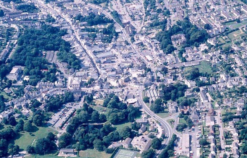
Cornwall and Scilly Urban Survey

Historic characterisation for regeneration

                  BODMIN
               HES REPORT NO. 2005R064

                    Graeme Kirkham

                    September 2005

                    HISTORIC ENVIRONMENT SERVICE
       Planning Transportation and Estates, Cornwall County Council
  Kennall Building, Old County Hall, Station Road, Truro, Cornwall, TR1 3AY
    Tel (01872) 323603 fax (01872) 323811 E-mail hes@cornwall.gov.uk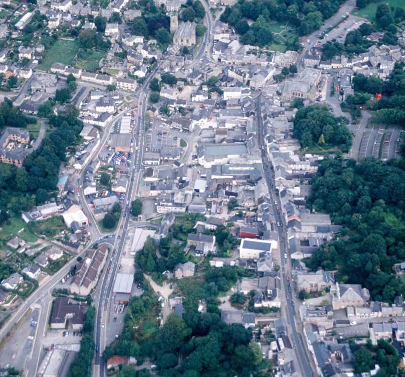
Acknowledgements
This report was produced by the Cornwall & Scilly Urban Survey project (CSUS), funded by English
Heritage, the Objective One Partnership for Cornwall and the Isles of Scilly (European Regional
Development Fund) and the South West of England Regional Development Agency. Peter Beacham (Head
of Designation), Graham Fairclough (Head of Characterisation), Roger M Thomas (Head of Urban
Archaeology), Ian Morrison (Ancient Monuments Inspector for Devon, Cornwall and Isles of Scilly) and Jill
Guthrie (Designation Team Leader, South West) liaised with the project team for English Heritage and
provided valuable advice, guidance and support.
Nick Cahill (The Cahill Partnership) acted as Conservation Advisor to the project, providing vital support
with the characterisation methodology and advice on the interpretation of individual settlements. Georgina
McLaren (Cornwall Enterprise) performed a key advisory role on all aspects of economic regeneration.
The Urban Survey Team, within Cornwall County Council Historic Environment Service, is Kate Newell
(Urban Survey Officer), Dr Steve Mills (Archaeological GIS Mapper; to July 2003) and Graeme Kirkham
(Project Manager to Spring 2004). Bryn Perry-Tapper is the CSUS GIS supervisor and has played an
important role in developing the GIS, HER and internet components of CSUS. Jeanette Ratcliffe was the
initial Project Co-ordinator, succeeded by Peter Herring from Spring 2003 and Peter Rose from Spring 2005.
Air photographs are from the Cornwall County Council Historic Environment Record. Other photographs
are by the report author and Nick Cahill.
Thanks are due for comments on the consultation draft of this report to Bodmin Town Council, Bodmin and
Surrounding Area Forum, North Cornwall District Council, Ann Kerridge CC, Steve Rogerson CC, Nick
Cahill (The Cahill Partnership) and Georgina McLaren (Cornwall Enterprise).

Maps
The maps are based on Ordnance Survey material with the permission of the Ordnance Survey on behalf of
the Controller of Her Majesty's Stationery Office (c) Crown copyright. Unauthorised reproduction infringes
Crown copyright and may lead to prosecution and/or civil proceedings. The map data, derived from
Ordnance Survey mapping, included within this publication is provided by Cornwall County Council under
licence from the Ordnance Survey in order to fulfil its public function to publicise local public services.
Cornwall County Council Licence No. 10019590.

Cover illustration
The centre of Bodmin from the south west, August 2003 (CCC Historic Environment Service, ACS 6052)

© Cornwall County Council 2005
No part of this document may be reproduced, stored in a retrieval system, or transmitted in any form or by
any means without the prior permission of the publisher.
Contents
Summary                                                                      1
1     Introduction                                                           5
    Regeneration and the historic towns of Cornwall and Scilly               5
    Characterisation and regeneration                                        5
    Cornwall and Scilly Urban Survey                                         6
    CSUS reports                                                             6
    Extent of the study area                                                 7
2     Bodmin: the context                                                    8
    Landscape and setting                                                    8
    The regeneration context                                                 9
    Historic environment designations                                       12
3     Historic and topographic development                                  13
    Before Bodmin – the prehistoric period                                  13
    Early medieval Bodmin                                                   13
    The medieval period                                                     15
    ‘From west to east along in one street’: Bodmin’s medieval topography   19
    Without priory or friary: Bodmin in the post-medieval period            24
    ‘Poor old Bodmin’                                                       27
    ‘The capital town of the Principality’                                  29
    Bodmin up to date                                                       40
4     Archaeological potential                                              43
    Indicators of archaeological potential                                  44
5     Bodmin: statement of significance                                     45
6     Present settlement character                                          46
    Physical topography and settlement form                                 46
    Survival of standing historic fabric                                    47
    Architecture, materials and detail                                      48
    Views and streetscapes                                                  51
    Identifying Character Areas                                             52
7     Regeneration and management                                           54
    Character-based principles for regeneration                             54
    The historic environment and regeneration: key themes for Bodmin        54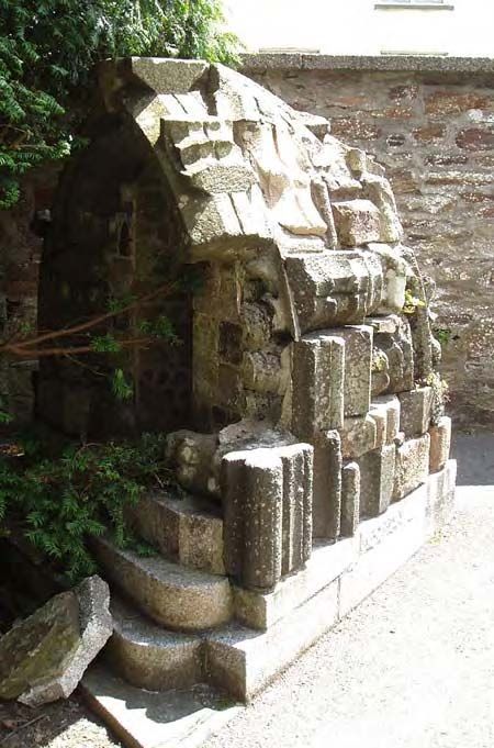
8       The Character Areas                                                         60
    1     Down Town: Fore Street, Honey Street and Mount Folly                      60
    2     Church Square, Turf Street, St Nicholas Street and Priory grounds         68
    3 Top Town: Lower and Higher Bore Street and St Leonard’s                       72
    4 Dennison Road - Berrycombe Road                                               77
    5 The Berry area: Church Lane, Castle Street and environs                       81
    6 The county institutions: St Lawrence’s, Bodmin gaol, Bodmin barracks          84
Appendix 1: archaeological interventions                                            89
Sources                                                                             90

Figures
Bound at the back of the report

1. Location and topography
2. Ordnance Survey 2nd edition 1:2500 map (c 1907)
3. Historic development
4. Historic settlement topography
5. Surviving historic components
6. Archaeological potential
7. Character areas
Character area summary sheets 1 – 6 (A3 fold-outs)

Abbreviations

CCC                    Cornwall County Council
CSUS                   Cornwall & Scilly Urban Survey
DCMS                   Department for Culture, Media and Sport
DTLR                   Department for Transport, Local Government and the Regions
EH                     English Heritage
GIS                    Geographical Information Systems
NCDC                   North Cornwall District Council
South West RDA         South West of England Regional Development Agency
TPO                    Tree Preservation Order
Cornwall & Scilly Urban Survey                                                               Bodmin

Summary                                             regeneration planning for the town and its
                                                    environs.
                                                    •   Bodmin’s historic built environment –
Cornwall & Scilly Urban Survey
                                                        buildings, historic topography and
The Cornwall & Scilly Urban Survey is a                 streetscapes – represents a major asset, the
pioneering initiative aimed at harnessing the           primary component of the town’s unique
quality and distinctive character of the historic       character, interest and significance. The
environment to successful and sustainable               importance of this distinctive ‘sense of
regeneration. The Survey is investigating 19            place’ in differentiating Bodmin from
historic towns and creating for each an                 other competing centres means that
information base and character assessment               actions which maintain and enhance the
which will contribute positively to                     historic environment are potentially key
regeneration planning. The project is based             contributions to regeneration.
within Cornwall County Council’s Historic           •   The urban hierarchy and diversity which
Environment Service and funded by English               Bodmin’s different Character Areas
Heritage, Objective One and the South West              represent are key elements of the town’s
RDA.                                                    character. Respect for this hierarchy and
                                                        for the distinctive differences between
Bodmin                                                  areas should be key considerations in
                                                        planning and executing future change.
The Objective One Single Programming
Document notes Bodmin as one of Cornwall’s          •   Bodmin’s natural setting is an important
major employment centres, with significant              element of its character, particularly in
capacity for increased commercial and                   terms of the striking views across the town
industrial activity. It offers the following            and to the surrounding countryside; the
profile of the town:                                    strong element of trees and greenery
                                                        within and around the historic urban area
   Bodmin, with 43% of its 12,775 population            is of major significance. These factors
   under 30, has the youngest age structure of          should be given appropriate consideration
   any of the Cornish towns. It is also one of          in conceiving and planning future change.
   the fastest growing, experiencing a 40%
                                                    •   Commitments to both achieving real
   increase between 1971 and 1996, despite
                                                        quality and to maintaining, enhancing or
   the rundown of a large hospital. Activity
                                                        reinstating    character     should    be
   rates are high and unemployment relatively
                                                        fundamental both in new developments
   low. Located at the intersection of the two
                                                        and changes in the public realm, and in
   main trunk roads, the A30 and A38,
                                                        approaches to repairing past mistakes.
   Bodmin has developed major new
   industrial estates and, in 1991, 21% of the      •   Bodmin should be perceived - and
   workforce worked in manufacturing or                 accordingly      managed,        presented,
   mining.                                              interpreted and promoted - as an historic
                                                        Cornish town of great quality, unique
Character-based principles for                          character and high significance.
regeneration

(See Section 7)
The following principles, derived from
analysis of Bodmin’s overall character and
assessments of its individual Character Areas,
are recommended as key components of all

September 2005                                 1                                            Summary
Cornwall & Scilly Urban Survey                                                                        Bodmin

Regeneration and the historic                             •   Review conservation designations
environment: key themes for Bodmin                        •   Identify, record and understand the
(See Section 7)                                               archaeological resource
                                                          •   Develop historic and cultural tourism.
Characterisation has highlighted a number of
regeneration and conservation opportunities,
which fall broadly into the following themes.
•   Recognise the asset represented by                    Character Areas and regeneration
    Bodmin’s distinctive character and high               opportunities
    quality historic environment
                                                          This study identified six distinct Character
•   Recognise and implement priority                      Areas within Bodmin’s historic urban area. Its
    opportunities for change                              findings on these areas (Section 8), together
•   Reinstate character and quality where                 with an assessment of overall settlement
    these have been eroded by inappropriate               character (Section 6), offer a means of
    past development or neglect                           understanding the past and the present. In
•   Build character into change                           turn, that understanding provides the basis for
•   Maintain and enhance the asset                        a positive approach to planning future change
                                                          which will maintain and reinforce the historic
•   Enhance streetscapes and the public realm
                                                          character and individuality of each area and of
•   Maintain the green element                            the town as a whole - sustainable local
•   Reduce the dominance of traffic and                   distinctiveness.
    parking

Character Areas and regeneration opportunities: summary
1 Down Town: Fore Street,          • Create a management plan for the Area, aimed at realising and
  Honey Street and                   maintaining the potential of the high-quality historic environment as a
  Mount Folly                        regeneration asset.
Bodmin’s commercial, retail and    • Undertake further THI-type initiatives to encourage high standards of
civic centre, with high-quality      maintenance and decoration on historic buildings.
historic buildings set along a     • Promote and enforce more appropriate shopfront design.
busy, narrow and strongly          • Improve the quality of public realm provision.
enclosed principal street and      • Explore LOTS-type schemes and promote new commercial uses to
around the town’s focal public       improve occupancy and utilisation.
space. The Character Area          • Work to reduce traffic flows and parking problems.
includes much of the medieval
                                   • Encourage new high-quality development on selected sites, targeted to
core of the town and derives its
                                     reinstate character.
layout from it.
                                   • Ensure design for future interventions in the area is fully informed by
                                     characterisation.
                                   • Maintain high density and enclosure in further developments on streets
                                     and lanes off Fore Street.
                                   • Improve access to and presentation of surviving burgage plots on the
                                     south side of Fore Street.
                                   • Treat Honey Street in a way which emphasises it as a primary historic
                                     axis.
                                   • Extend the Conservation Area to incorporate the surviving area of
                                     burgage plots south of Fore Street.
                                   • Apply robust conservation management to historic buildings, backed if
                                     necessary by new Article 4 directions.

September 2005                                 2                                                    Summary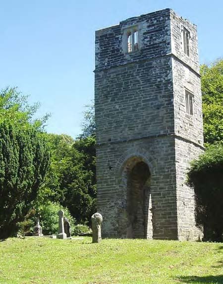
Cornwall & Scilly Urban Survey                                                                          Bodmin

2 Church Square, Turf Street,        • Seek reduction in traffic levels; improve pedestrian facilities.
  St Nicholas Street and             • Promote appropriate redevelopment of sites on Priory Road / Church
  Priory grounds                       Square.
This Area fringes and is             • Maintain the well-kept park character of the former priory grounds.
secondary      to        Bodmin’s    • Improve presentation and interpretation of historic monuments in the
commercial and civic core              area.
(Character Area 1). It includes St   • Improve the quality of public realm provision.
Petroc’s church, some large          • Apply robust conservation management to historic buildings, backed if
houses, residential streets and        necessary by new Article 4 directions.
open green space.
3 Top Town: Lower and                • Bore Street should be perceived and treated throughout its length as a
  Higher Bore Streets and              principal urban street rather than as a major through road.
  St Leonard’s                       • Improve the quality of public realm provision.
A very long and wide,                • Explore potential for additional street trees along the length of Bore
predominantly residential street       Street.
of strong urban character. It        • Ensure that new development maintains the characteristic tight street
fossilises the site of a medieval      frontage of the Area.
fair on one of the major historic    • Promote appropriate redevelopment around the junction of Lower
routes into Bodmin.                    Bore Street with Robartes Road and Finn VC estate.
                                     • Extend the Conservation Area to incorporate historic buildings at the
                                       southern end of Robartes Road.
                                     • Apply robust conservation management to historic buildings, backed if
                                       necessary by new Article 4 directions.
4 Dennison Road –                    • This area offers the most significant regeneration opportunity for
  Berrycoombe Road                     Bodmin, with potential to recreate it as an urban quarter of quality and
Formerly occupied by a mix of          significance. A master plan is required to co-ordinate the process.
residential,     industrial  and     • Include Bodmin Gaol in regeneration planning for this Area.
communications uses, this area       • Improve the quality of public realm provision.
has been subject to major change     • Seek improvements to the appearance of commercial premises and
since the mid twentieth century,       service areas at the rear of plots on the north side of Fore Street.
resulting in substantial loss of     • Extend the Conservation Area to incorporate those parts of the Area
historic fabric and topography. It     which retain significant historic character.
is traversed by a busy main          • Apply robust conservation management to the surviving historic
through route and service uses         structures, backed if necessary by new Article 4 directions.
associated with cars and traffic
predominate.

September 2005                                   3                                                    Summary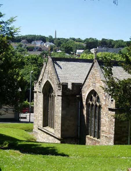
Cornwall & Scilly Urban Survey                                                                           Bodmin

5 The Berry area: Church             • New development should be strongly guided by the historic character
  Lane, Castle Street and              and avoid ‘suburbanisation’.
  environs                           • Exercise care over conversion of large historic buildings to apartments;
A quiet suburban area of               ensure that character is not eroded by additional parking, new access
cottages, former farms and             through historic boundaries, etc.
smallholdings, villas and larger     • Maintain surviving undeveloped plots as green spaces.
houses and institutions, with        • Retain historic buildings and normal public access in re-development
trees, gardens and greenery, set       of the East Cornwall Hospital site.
around an historic grid of streets   • Extend the Conservation Area to include the whole of the Character
overlooking the centre of              Area.
Bodmin from the hillside to the      • Apply robust conservation management to the surviving historic
north.                                 structures and boundary features.
                                     • Provide direction signage for Berry Tower; promote the area as an
                                       historic part of Bodmin.
                                     • Take steps to maintain the wooded character of the Area in the long
                                       term.
                                     • Undertake limited tree management to achieve glimpses of Berry
                                       Tower.
6 The county institutions: St        • Recognise that these complexes are of significance to Cornwall as a
  Lawrence’s, Bodmin gaol,             whole and should be treated as places of county-wide importance.
  Bodmin barracks                    • Retain the visual integrity of the complexes.
Three discrete areas on the outer    • Prioritise a programme for the whole of the historic prison complex
edge of Bodmin’s historic extent       aimed at conserving the fabric and bringing it into full use and
are characterised by the presence      contribution.
of large complexes of well-          • Ensure that the prison complex is incorporated in regeneration
designed nineteenth-century            planning for the adjacent Dennison Road – Berrycoombe Road area
institutional buildings set within     (Character Area 4).
strongly bounded grounds.
                                     • Ensure that the park-like character of the grounds to St Lawrence’s is
                                       retained. Explore potential for new public access green-space on the
                                       site.
                                     • Enable access to the complexes for public appreciation.
                                     • Improve the public realm at West End and around Bodmin General
                                       station.
                                     • Maintain and develop levels of tree cover, including roadside trees.
                                     • Extend the Conservation Area to include all of the historic structures
                                       within these Character Areas.
                                     • Apply robust conservation management to the surviving historic
                                       structures and boundary features.

September 2005                                    4                                                    Summary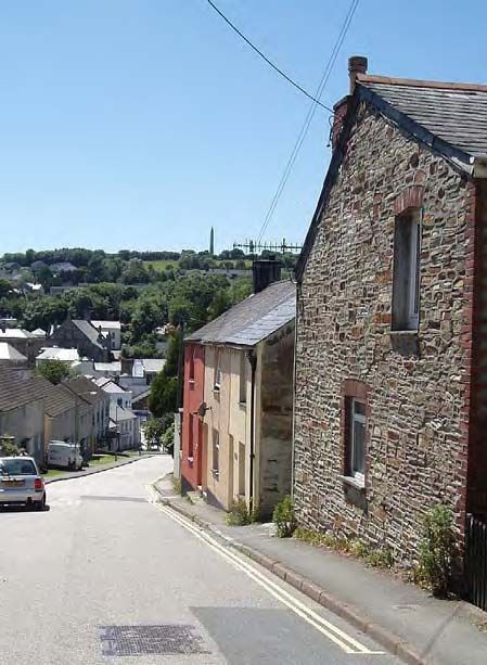
Cornwall & Scilly Urban Survey                                                                      Bodmin

1 Introduction                                      environment carried out by English Heritage
                                                    in 2000, and its value clearly highlighted in the
                                                    government’s       response,        The   Historic
                                                    Environment: A Force for the Future (2001). The
Regeneration and the historic towns                 tool by which the two may be linked to create
of Cornwall and Scilly                              a framework for sustainable development in
                                                    historic settlements is characterisation.
In July 1999 Cornwall and the Isles of Scilly
were designated as an Objective One area,           Characterisation and regeneration
bringing potential investment from European
funds of more than £300m over the nine-year
spending period. Economic regeneration                 ‘The government . . . wants to see more regeneration
schemes and development projects within the            projects, large and small, going forward on the basis
region’s towns are likely to form a major              of a clear understanding of the existing historic
element of the Objective One Programme.                environment, how this has developed over time and
                                                       how it can be used creatively to meet contemporary
Regeneration on this scale offers an                   needs.’
unparalleled opportunity for contemporary
contributions in urban design and architecture         (DCMS / DTLR 2001, The Historic Environment:
                                                        A Force for the Future, 5.2)
to the built environment of Cornwall and
Scilly’s towns. At the same time, the Objective     ‘Characterisation’ provides a means of
One programme emphasises environmental              understanding the diverse range of factors
sustainability    (including     the    historic    which combine to create ‘distinctiveness’ and
environment) and regional distinctiveness as        ‘sense of place’. It involves the creation of a
key considerations in regeneration planning.        comprehensive knowledge base on the
The process of change launched by current           historic environment. This includes what is
regeneration initiatives could, if not carefully    known of a settlement’s historic development
managed, have a negative impact on the              and urban topography (that is, the basic
historic environment and the unique character       components which have contributed to the
and sense of place of each of these                 physical shaping of the historic settlement,
settlements. The pressure to achieve rapid          such as market places, church enclosures,
change could in itself result in severe erosion     turnpike roads, railways, etc), together with an
and dilution of their individuality and             overview of the surviving historic fabric,
particular distinctiveness and, at worst, their     distinctive architectural forms, materials and
transformation into ‘anywhere’ towns.               treatments and the significant elements of
It is clear from recent research that a high-       town and streetscapes. Characterisation may
quality historic urban environment and the          also provide the basis for assessing the
distinctiveness and sense of place integral to it   potential     for     buried     and    standing
are themselves primary assets in promoting          archaeological remains and their likely
regeneration. The effect may be direct,             significance,     reducing    uncertainty    for
through heritage tourism, for example, but          regeneration interests by providing an
there is a more powerful and decisive impact        indication of potential constraints.
from such distinctiveness in prompting a            Characterisation is also a means whereby the
strong sense of identity and pride of place         historic environment can itself provide an
which in turn creates a positive and confident      inspirational matrix for regeneration. It
climate for investment and growth.                  emphasises the historic continuum which
This     synergy   between     the     historic     provides the context for current change and
environment and economic regeneration was           into which the regeneration measures of the
recognised and strongly advocated in the Power      present must fit if the distinctive and special
of Place review of policies on the historic         qualities of each historic town are to be

September 2005                                 5                                             Introduction
Cornwall & Scilly Urban Survey Bodmin
maintained and enhanced. It both highlights CSUS is a pioneering initiative aimed directly
the ‘tears in the urban fabric’ wrought by a at cutting across the boundary that
lack of care in the past and offers an traditionally divides conservation and
indication of appropriate approaches to their economic development. Nationally, it is the
repair. first such project carrying out a
characterisation-based assessment of the
Characterisation is not intended to encourage
historic urban environment specifically to
or to provide a basis for imitation or pastiche;
inform and support a regional economic
rather, it offers a sound basis on which the
regeneration programme. Future regeneration
twenty-first century can make its own distinct
initiatives in other historic settlements, in
and high-quality contribution to places of
Cornwall and Scilly and further afield, will
abiding value.
benefit from the new approach developed by
the project.
Cornwall and Scilly Urban Survey
CSUS reports
The Cornwall & Scilly Urban Survey (CSUS)
was set up – funded by both English Heritage
CSUS reports present the major findings and
and the Objective One Partnership for
recommendations arising from the project’s
Cornwall and Scilly (European Regional
work on each town. They are complemented
Development Fund) – as a key contributor to
by computer-based digital mapping and data
regeneration in the region. Additional funding
recorded using ArcView Geographical
has been provided by the South West of
Information System (GIS) software, and
England Regional Development Agency. The
together the two sources provide
project is investigating 19 historic towns and
comprehensive information on historic
creating for each the information base and
development, urban topography, significant
character assessment which will provide a
components of the historic environment,
framework for sustainable action within these
archaeological potential and historic character.
historic settlements.
Importantly, the reports also identify
These towns have been identified, in
opportunities for heritage-led regeneration
consultation with planning, conservation and
and positive management of the historic
economic regeneration officers within the
environment. However, they are not
seven district, borough and unitary authorities
intended to be prescriptive design guides,
in the region, as those which are likely to be
but should rather be used by architects,
the focus for regeneration. The project’s
town planners and regeneration officers to
‘target’ settlements are:
inform future development and planning
Penzance Newlyn strategies.
St Ives Hayle The reports and associated digital resources
Helston Camborne are shared with the appropriate local
Redruth Falmouth authorities; economic regeneration, planning
Penryn Truro and conservation officers therefore have
immediate access to the detailed information
Newquay St Austell generated by the project. Additional
Bodmin Camelford information is held in the Cornwall and Scilly
Launceston Liskeard Historic Environment Record, maintained by
Saltash Torpoint the Historic Environment Service of Cornwall
County Council.
Hugh Town
Public access to the report and to the
associated mapping is available via the
September 2005 6 IntroductionCornwall & Scilly Urban Survey Bodmin
project’s website - www.historic- by the current Local Plan. However, the
cornwall.org.uk - or by appointment at the detailed characterisation and analysis of urban
offices of Cornwall County Council’s Historic topography which together form the primary
Environment Service, Old County Hall, elements of this study are closely focused on
Truro. the historic urban extent of the settlement. For
the purposes of the project this is defined as
Extent of the study area that which is recognisably ‘urban’ in character
on the 2nd edition Ordnance Survey 1:2500
map of c 1907-8 (Figs. 1 and 2).
The history and historic development of each
town are investigated and mapped for the
whole of the area defined for the settlement
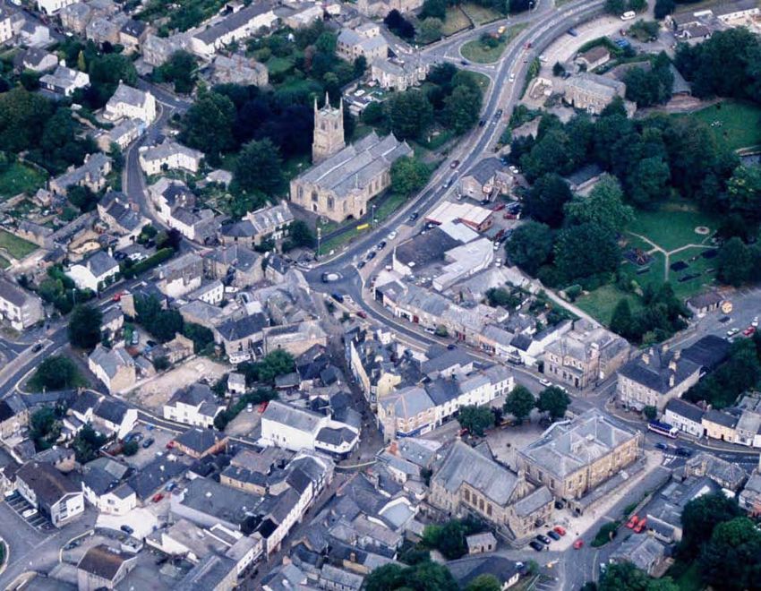
Bodmin from the east, August 2001 (Historic Environment Service, ACS 5445).
September 2005 7 IntroductionCornwall & Scilly Urban Survey Bodmin
2 Bodmin: the context ‘historic’ north-south route – recently titled
the ‘Saint’s Way’ – between Padstow and
Fowey. Such a route is not in fact well attested
historically, but some element in the
Landscape and setting development of the settlement in the early
medieval period and later may be attributable
Bodmin lies at the centre of Cornwall, both to its position mid-way between the highest
geographically (the precise centre being just navigable points on the Camel and Fowey
two miles to the west at Lanivet) and in terms rivers, then probably only about 10 km apart.
of the communications network. Cornwall’s John Leland referred in about 1540 to
spinal trunk road, the A30, is joined here by Bodmyn Pill (south of Golant) on the Fowey
the main road from Plymouth and Liskeard, as a ‘having [i.e., haven or harbour] for wares
the A38, and the busy A389 links the town then to be carried to Bodmin’. This was
with the A39 ‘Atlantic Highway’ running up presumably a later medieval replacement for
the north coast. The main rail line passes a Lostwithiel as a transhipment point, after
short distance to the south of the town with a navigation of the upper part of the Fowey
station at Bodmin Parkway, 5km from the became difficult because of silting resulting
town centre. from streamworking for tin upstream on
The town lies on an ancient, possibly Bodmin Moor; the upper reaches of the
prehistoric, east-west route through Cornwall, Camel were also subject to silting but prior to
perpetuated by the A30 and before that by the the medieval period may have been navigable
Bodmin-Launceston turnpike. It is also as far upstream as Nanstallon.
sometimes noted as being located on an
Recently Enclosed Land around Bodmin Beacon, 2001. This area of former unenclosed downland was partitioned into
regular straight-sided fields in the first half of the nineteenth century (Historic Environment Service, F55/13).
September 2005 Bodmin: the context
8Cornwall & Scilly Urban Survey Bodmin
The Camel curves past Bodmin in the deep later twentieth century expansion has taken
wooded valley of Dunmere, 2 km west of the place over such Recently Enclosed Land.
church. Dunmere Bridge carries the A389, the Anciently Enclosed Land, in the form of
historic road to Wadebridge and beyond to enclosed parcels of former strip fields
Padstow. The Camelford road, an old associated with farming hamlets such as
ridgeway, but now the B3266, branches off a Bodiniel, Penbugle and Lancarffe, lies close to
mile to the north. To the south east the Fowey the town on the northern side, with a swathe
River comes closest at Respryn, 3.5 kilometres of similar terrain, intermixed with ancient
from the church, and the late medieval bridge woodland, extending north towards Helland
here took the old road to Liskeard, Saltash and and Pencarrow. Even here, however, the tops
the world beyond the Tamar. The grounds of of many of the hills in Helland parish, and to
Lanhydrock house (and parish) provide an the east around Cardinham, have been
ornamental buffer between Bodmin and the enclosed and improved for agriculture only in
wooded valleys of the Fowey and its the last two hundred years.
tributaries the Cardinham and Maudlin
Waters. Lostwithiel, the nearest urban The regeneration context
neighbour, 9 km to the south, is reached by
another old ridgeway (now the B3268). This
ran through the divide between Bodmin’s two Georgina McLaren, Cornwall Enterprise
great southern hills, the Beacon (162m) and Bodmin is located near the geographical
Castle Canyke (166m), the latter crowned with centre of Cornwall, south west of Bodmin
a great prehistoric enclosure. Bodmin General Moor. The two main roads into and through
station was later built in this divide, the Cornwall, the A30 and the A38, converge on
nearest the difficult topography would allow the outskirts of the town, giving it an
the railway to get to Bodmin town; the important strategic position for employment
looping lines running east and west to Bodmin and tourism. Bodmin is the largest town in
Road and Boscarne stations pick out the hills’ North Cornwall and has experienced
contours nicely. At Halgavor the Lostwithiel significant growth since 1965. In the 1960s
road crosses by a bridge (previously a ford) and 1970s substantial areas of new public
the stream (possibly once called St Lawrence sector housing were developed in association
Water?) whose gently sloping valley wraps with the Greater London Council overspill
around the south side of the Beacon. scheme. The population was recorded as
Until the early modern period Bodmin was a 12,881 at the 2001 census. In-migration and
town almost encircled by open downs, heaths the building of the A30 bypass have been key
and moors. Carew wrote of Halgaver c 1600 factors in the growth of new light industrial
that ‘the name signifieth the Goat’s Moor, and activity on the eastern edge of the town, close
such a place it is, lying a little without the to the A30. Tourism is also important to the
town, and full of quagmires.’ Leland in the local economy and Bodmin hosts a number of
1530s found the road from St Laurence’s to attractions including the Bodmin and
Mitchell, ‘hilly and moory ground’. This Wenford Railway and the Camel Trail.
setting is reflected in the 1994 Historic Bodmin acts as a district service centre and
Landscape Characterisation of Cornwall, currently has a full range of social and
which identifies much of the area to the east, community facilities relating to education,
west and south of the town as Recently health, shopping, leisure, recreation and public
Enclosed Land, typified by the straight-sided transport. There are regular bus services to
early nineteenth century fields which now nearby towns including Wadebridge, Padstow,
subdivide the Beacon; prior to enclosure these St Austell, Camelford and Truro, and to the
areas would have been open rough ground, nearby Bodmin Parkway Station, which is on
primarily used for extensive grazing and as a the main London to Penzance railway line.
source of domestic fuel. Much of Bodmin’s
September 2005 Bodmin: the context
9Cornwall & Scilly Urban Survey Bodmin
An important and unique feature in the in Cornwall and six SOAs in the top 10
regeneration context is Bodmin’s legacy from ranked for employment deprivation.
its period as the county town. As such, the
Levels of car ownership are generally lower
town has a significant number of substantial
than the county standard, although the
nineteenth-century government properties.
percentage of ownership of one car per
Some have been adapted or developed
household is slightly higher than the Cornwall
relatively recently, whilst others still present
average of 48.7% (50.6% in St Mary’s and
significant future opportunities. These
50% in St Petroc’s). St Mary’s ward has, at
buildings and sites include Bodmin Barracks
27%, a higher than national average
(now employment land, home of the
percentage of households with no cars. The
Environment Agency, the DCLI regimental
county average is 20.5%.
museum and new and converted housing), the
former Assize Courts (now the Shire Hall Employment, business and industry
living courts museum and visitor centre), the The predominant employment sectors in
Judges’ Lodgings (Bodmin Town Council Bodmin are wholesale and retail trade, light
offices) and the County Lunatic Asylum (St manufacturing, health and social work,
Lawrence’s Hospital), the latter now being construction and real estate, and renting for
developed for private housing and as a tourism. A large proportion of businesses in
flagship Business Park (Beacon Technology Bodmin are micro-businesses, employing five
Park) by SWRDA. Walker Lines, a legacy of or fewer people (Bodmin Parish Profile 2005).
World War II, is now an industrial estate. One From 1991-2001 employment levels in
remaining important building in private Bodmin rose from 34.3% to 36.9%, whilst
ownership that still awaits major regeneration unemployment fell from 6.2% to 3.9%.
plans is Bodmin Gaol. During the same period the number of part-
time employees and students has increased
Socio-economic profile and the number of self-employed people has
decreased slightly.
Population profile
There are two wards in Bodmin, St Mary’s and A town centre Health Check was carried out
St Petroc’s, with populations at the 2001 in 2000 by consultants to provide baseline
census of 6,806 and 6,075 respectively. Both information concerning the economic and
wards show the proportion of population of environmental health of the town. Key
working age is considerably higher than those findings included that around 1,000 people
aged under 15 and over 65. From 1999 to were employed in the town centre and that
2001 the 20-44 years population age group there were 175 retail units in Bodmin Town,
decreased whereas population age group 45+ mainly concentrated around Fore Street. The
years increased. This is possibly a result of the Health Check concluded that retail space in
younger working population being forced out the town centre had fallen by 11% from
of the housing market and moving away to 116,290 sq ft in 1987 to 103,820 sq ft in 2000.
find better paid, higher quality jobs. It is also Comparison goods shopping (defined as non-
reflective of the influx of people in the early perishable goods which stocked in a wide
1970s. range of sizes, styles, colours and qualities,
such as furniture, carpets, televisions, etc) has
Indices of deprivation become relatively more dominant, while
The Indices of Multiple Deprivation 2004 services and vacant space have remained
breaks Bodmin down into nine Super Output broadly the same; convenience goods
Areas (SOAs). Five of these SOAs are in the shopping (relatively inexpensive frequently
ten ranked most deprived in North Cornwall purchased consumer goods) has fallen. One of
and three are in the top 20% most deprived in the key findings from the Health Check was
the whole county. Five of the SOAs are that there was a need for more ‘multiple
ranked in the top 20% for income deprivation stores’, particularly in clothing, as this would
September 2005 Bodmin: the context
10Cornwall & Scilly Urban Survey Bodmin
improve the attraction of the town as a aimed at improving, refining and expanding
shopping destination. the tourism product and market in the district.
Bodmin is a town that offers further potential
Recent and current initiatives in this area.
A programme of town centre enhancements As the result of the regeneration initiatives in
was carried out between 1998 and 2002, 1998-2002 and the subsequent Bodmin
including conversion of the Assize Courts, Market and Coastal Towns Initiative, a local
landscaping of Mount Folly, new car parking representative forum - Bodmin Futures - has
provision, streetscape improvements and evolved. In March 2005 Bodmin Futures
traffic calming in Fore Street. This built upon published its 2020 vision for Bodmin and the
earlier works carried out in Honey Street. A six surrounding parishes of Helland,
Townscape Heritage Initiative led to Lanhydrock, Lanivet, Withiel, Blisland and
successful refurbishment of a number of Cardinham. The vision covers all aspects of
privately owned derelict and dilapidated community life and is built on core values of
buildings in the town centre. quality and partnership; it focuses on the
creation of a twenty-first century economy.
Bodmin ‘Pride and Place’ is a three-year
initiative aiming to strengthen the town’s Specific projects envisaged under the Futures
unique landscape and cultural identity and to vision include undertaking an urban design
use creativity to heighten its sense of place. study to create a development and marketing
Starting in April 2004, the project has begun framework for the town centre and
to assist local communities within and round Conservation Area, encouraging preservation
Bodmin to recognise the unique character of of the historic built environment and
the area and to record and celebrate its promotion of an ‘open building programme’
diversity and richness. Activities include for greater public access to important
making tree sculptures, working with local buildings. There are also proposals for
schools and the Cornwall Audio Visual improved interpretation, including walking
Archive and running community workshops tours and measures to promote and increase
and local exhibitions. understanding of ancient monuments and
archaeological sites.
In August 2003 a new East Cornwall Materials
and Recycling Facility was set up in Bodmin Future planning approaches
by North Cornwall District Council and
Caradon District Council in partnership with North Cornwall Local Plan
Cornwall Paper Company. The facility has a The Local Plan was adopted in 1999 and will
visitor centre so that local schools and be succeeded by a new Local Development
community groups can find out more about Framework in 2007. The Local Plan Annual
recycling and watch the whole process from Monitoring Report 2003/2004 indicated that
the viewing gallery. most of the local plan policies were operating
The Walk to Work project in Bodmin is being successfully and were progressing to meet the
led by the Coast and Countryside Service of relevant Local Plan objectives.
NCDC to encourage walking and cycling to The Local Plan’s overall aim was ‘to develop
work and school for leisure and health. The Bodmin’s role as the main centre for job
project involves creating new safe off-road opportunities, services and facilities in mid-
routes across the town and an extension of the east Cornwall’. This approach recognised that
Camel Trail to bring this closer to the town Bodmin has the strategic location,
centre. development opportunities and infrastructure
The North Cornwall Tourism Strategy 2001- to accommodate development without undue
2005 sets out a range of strategic objectives detriment to the environment. The growth of
September 2005 Bodmin: the context
11Cornwall & Scilly Urban Survey Bodmin
the town would also help to sustain and development should consolidate the current
enhance services for the rural hinterland. employment and retail function of the town,
maintaining the balance of homes and jobs.
Housing: Between 1991-2 and 2000-1, there
The Structure Plan also designates Bodmin as
were 477 house completions in Bodmin; a
a Strategic Urban Centre, the only one in
further 124 completions took place in 2001-2.
North Cornwall, and recognises the town as
Permissions have been implemented at St
the largest population centre in the district.
Lawrence’s Hospital site, Scarlett’s Well Park,
Respryn Road and Green Lane to meet Local Development Framework
housing requirements, in addition to North Cornwall District Council published
developments at various infill sites within the key results on the Local Development
built-up area of the town. Framework Issues and Options Report
Industry and employment: Industrial consultation in November 2004. Issues to be
development in Bodmin has concentrated on addressed in assessing the capacity of Bodmin
the east side of the town where there is good to accommodate further growth include:
access to both the A30 and the A38. The environmental impact, infrastructure, social
Local Plan highlighted that in addition to the and community facilities, employment
conventional industrial estates, Bodmin’s opportunities, availability of previously
strategic location would be suitable for a developed land and availability of greenfield
business park development that could cater sites. Three areas have been identified in the
for the special needs of high technology, undeveloped corridor to the east between the
research and development and high profile eastern residential suburbs and the A30, where
business establishments. There was also an allocations for future development for
opportunity for mixed development with housing and employment are likely to be
possibilities of housing where appropriate to made. Issues were raised in relation to the
introduce the concept of Live-Work that is provision of adequate infrastructure and social
currently being explored in other parts of the and community facilities in Bodmin.
county.
Historic environment designations
Town centre and retail development:
Bodmin provides a reasonable range of
facilities although there are many Current historic environment designations for
opportunities for these to be improved in Bodmin include two Scheduled Monuments
order to attract more residents and visitors to (Berrycoombe Cross and the chapel of
choose Bodmin as a destination for shopping Thomas à Becket) and more than 100 Listed
and entertainment. The Local Plan stated that Buildings. The latter include St Petroc’s
the future success of the town centre would church (Grade I) and several Grade II*
depend upon consolidating and increasing structures: St Lawrence’s Hospital, Shire Hall,
town centre activity in a well defined area and Shire House, St Guron’s well and the chapel
creating an attractive town centre environment of Thomas à Becket (both within St Petroc’s
with plenty of convenient car-parking. A churchyard), and several crosses. Much of the
number of traffic management and historic extent of the town has Conservation
environmental schemes in the public realm Area status, with the most recent major
have since taken place to address this issue. amendment dating from c 1999. There is
potential for some significant amendments to
Cornwall Structure Plan its extent (see Section 7).
The general planning approach described in
the Cornwall Structure Plan 2004 is that
September 2005 Bodmin: the context
12Cornwall & Scilly Urban Survey Bodmin
3 Historic and topographic Penhargard, north of Bodmin, Colesloggett,
Tawnamoor and Kingswood to the east, St
development Ingunger to the south and Lamorick, in
Lanivet parish, to the south west. The ‘Berry’
Figures 3 and 4 give an overview of Bodmin’s and ‘Castle’ names which occur on the
historic development and historic topography northern valley side above the town may
record the presence of another enclosed site
Before Bodmin – the of this period (see below).
prehistoric period At Nanstallon, the remains of a Roman fort –
the only one firmly identified in Cornwall to
The earliest known evidence for human date – have been excavated and shown to
activity in the Bodmin area is a scatter of have been occupied for only 20-30 years in the
worked flint of probable Mesolithic date second half of the first century AD. The
(c 8,000-4,000 BC) from Castle Canyke, south proximity of this site to what was probably
east of the town. The sites of Bronze Age then the highest navigable point on the Camel
barrows, dating from approximately 2,500- may indicate that it was sited to defend, or to
1200 BC, are known or suspected on Bodmin function as, a shipment point for maritime
Beacon, the former Bodmin Down south of trade. Evidence was found there of
Barn Lane (with a stone cist nearby) and metalworking in silver and possible iron
within the barracks; there are barrow groups smelting. Roman coins have occasionally been
to the west of the town at Boscarne and found in the vicinity of Bodmin, including
Tregear and on Penaligon and New Downs. examples from St Petroc’s.
Early medieval Bodmin
The eleventh and twelfth century Lives of St
Petroc attributed the origins of a settlement at
Bodmin to the saint having gone into a
‘remote wilderness’ inland from his earlier
foundations at Padstow and Little Petherick
and there taking over the dwelling of a hermit,
St Uuron. Petroc’s followers joined him,
according to these sources, eventually
necessitating the construction of a second
Castle Canyke, Cornwall’s largest Iron Age hillfort, monastic house on the hill above an earlier
surrounded by the remains of a substantial ditch and foundation in a valley. There is currently no
rampart; these have been much reduced by ploughing archaeological or documentary evidence to
on the eastern side. The interior was subdivided and support an early religious settlement in or near
enclosed in the post-medieval period (Historic Bodmin, however, and it is worth noting that
Environment Service, ACS 714). such medieval legends were often constructed
long after the events they purported to
Activity in later prehistory is represented by describe to explain and provide a history and
Castle Canyke, the largest Iron Age hillfort in pedigree for foundations existing at the time
Cornwall, south east of the town, and another they were written. The available evidence
very substantial enclosure of this period in rather suggests that a monastic or clerical
Dunmere Wood, to the north west. A number settlement associated with the cult of St
of rounds or defended farmsteads of the Iron Petroc, established earlier at Padstow, was
Age – Romano-British period are known in founded at Bodmin at some point in the later
the wider area of the town, including sites at centuries of the early medieval period. This
September 2005 Historic and topographic development
13Cornwall & Scilly Urban Survey Bodmin
may have been around AD 800: it has been element ‘berry’ in this area, with documentary
suggested that Bodmin was the site of a evidence to date this association to at least the
monastery or church named as Dinuurrin in a fourteenth century. The word perhaps derives
documentary source dated between AD 833 from the Old English burh, meaning a
and AD 870. At this time the monastery was defended site, and therefore suggesting a link
the seat of a bishop named Kenstec, the with the Cornish element din, a fort, which
document recording his pledge of allegiance to occurs in Dinuurrin. No archaeological
the Anglo Saxon church centred on evidence for such a feature has been identified
Canterbury. This part of Cornwall appears to to date but there are local accounts of a
have already come under Saxon control by possible site at Castlehill; the physical
this period: much of the land formerly held by topography would suggest a possible location
the earlier monastic foundation dedicated to on the ridge east of the house of that name on
St Petroc at Padstow had been granted away the upper part of Castle Street. It has also
by King Ecgberht in the wake of his military been argued that the late fifteenth century
actions in Cornwall in the early ninth century; church of the Holy Rood, surviving now as
removal from Padstow to Bodmin may have the Berry Tower, was constructed on an early
occurred because the latter was a more ecclesiastical site.
convenient base from which to manage the If such a monastic settlement on the northern
remaining monastic estates.
valley side did exist, the settlement which grew
By the later tenth century Bodmin had up around the site of the present St Petroc’s
become the primary centre of the monastic church could represent a later phase, perhaps
foundation dedicated to St Petroc, perhaps associated with the founding of a second
encouraged by Viking raids in the Camel monastic establishment. The place-name
estuary in AD 981. The manumissions - that Bodmin is itself likely to derive from the
is, formal grants of freedom to slaves - Cornish elements, bod + meneghi, with the
recorded in the tenth-century Bodmin probable meaning ‘dwelling by church-land’.
Gospels demonstrate that the Bodmin Early medieval activity in the area of the
foundation was at this time closely integrated present town is attested by finds of distinctive
with the wider Anglo-Saxon political and ‘grass-marked’ pottery from the western end
religious orbit: slaves are noted as having been of the site of the former Priory (Priory House)
freed for the benefit of the souls of several and from the area of the car park constructed
later tenth century Saxon kings (Edmund, on the steep slope behind Mount Folly, south
Eadred, Eadwig), bishops, nobles and others. of the east end of Fore Street. Such pottery
There are also hints of an organised urban or typically dates from between the seventh and
proto-urban settlement with its own officials. eleventh century and its presence, probably
One of the manumission entries records an resulting from the manuring of agricultural
individual purchasing a female slave and her land with household waste, provides an
son ‘at the church door in Bodmin’, paying a indication of settlement in the near vicinity.
toll to ‘Aeilsige the portreeve’ (broadly
equivalent to a mayor or chief magistrate) and One factor in the development of a settlement
another official, and then freeing the two at Bodmin at this period is likely to have been
individuals ‘on St Petroc’s altar’. the presence nearby of the tin industry.
Evidence for this comes from finds made at
The location of the early elements of the Boscarne in the early nineteenth century.
monastic foundation and developing These included a tin ingot and an early tin
settlement has been the subject of some smelting site, together with the remains of oak
debate. The early ninth century monastery shovels; the latter have been radiocarbon
named Dinuurrin may have been on the hill dated to the period AD 635-1045 and were
north of the centre of Bodmin. There are a almost certainly associated with
number of place-names which include the streamworking.
September 2005 Historic and topographic development
14Cornwall & Scilly Urban Survey Bodmin
The medieval period
Domesday book noted Bodmine as held in 1086
by St Petroc’s church, recording also that ‘St
Petroc’s has 68 houses and a market’. By this
point, therefore, Bodmin was already a small
town, one of only three in Cornwall at this
period (the others were Liskeard and St
Stephen-by-Launceston). Bodmin’s market
was again recorded in 1201 and a fair, known
as the Longfair and said to be held in the
king’s highway, was documented in 1274. The
market and additional fairs were noted again
in 1302.
Ornately carved stonework revealed during
The monastery of St Petroc was re-established
archaeological excavations on the priory site in 1985.
as a foundation of Augustinian canons in the
1120s or 1130s, one of a number of such The priory had substantial estates for its
changes in the south west at this period support, including the town of Bodmin and
whereby former monastic settlements of large areas around Lanhydrock, Withiel,
‘secular canons’ were converted to priories. Rialton and Padstow. There are also
Bishop Warlewast of Exeter appears to have indications that it possessed two or three deer
promoted similar moves at Launceston, with parks in the vicinity of Bodmin: a document
the founding of the priory at St Thomas, and of 1389 referred to a ‘park by St Leonard’,
at Plympton. At Bodmin a new priory ‘Borhull park’ and ‘Scu’s park . . . with
complex was developed on a site a short meadows therein’. The locations and
distance south east of the earlier monastic site boundaries of these parks are not known but
(now St Petroc’s church). This may not have that referred to as ‘by St Leonard’ was
occurred immediately: excavations in the mid presumably to the west of the town, beyond
1980s uncovered the north-west corner of the the chapel of St Leonard at the west end of
aisled priory church and dated it to the late Bore Street; the tithe apportionment recorded
twelfth or early thirteenth century. a block of fields named ‘Deer Parks’ to the
north of the junction of Boundary Road and
The new priory church would have been an
Boskear Lane and the name ‘Eastpark
impressive structure. ‘One of the finest
Cottages’, shown on the south side of
buildings in Cornwall’ of the time, suggested
Westheath Avenue on the 1st edition
Charles Henderson, and the architectural
Ordnance Survey 1:2500 map of c 1880 may
historian E H Sedding was confident from the
also be relevant. ‘Borhull’, if it incorporates
surviving fragments of worked stone that the
the same ‘bore’ element which appears in Bore
‘Norman architecture in Bodmin Priory must
Street, may indicate a further park to the west
have been equal to any specimens of their
of the town.
work in Great Britain’. The church was part of
a substantial group of buildings which The shrine of St Petroc which had previously
included a cloister, dormitory, chapter house, been kept in the monastery was removed to
refectory and prior’s lodgings; a graveyard also the priory, representing a considerable asset, in
developed around the priory – human remains terms of both the popular legitimacy it
have been found on several occasions over the conferred on the new institution and the
past century – and the complex was bounded offerings it attracted from visitors. The saint’s
by extensive walled and gated grounds. relics are said to have been stolen from the
priory within a few decades of its foundation
and taken by a monk to his home monastery
September 2005 Historic and topographic development
15Cornwall & Scilly Urban Survey Bodmin
at St Méen in Brittany; they were restored in the south side of Mount Folly Square. The
1177, housed in an ivory reliquary (now in St church itself lay on the site of the present
Petroc’s church). This story now forms part of Shire Hall and Public Rooms and it is likely
the rich store of legends which has built up that other buildings, set around a cloister,
around Bodmin’s religious history, but it is not ranged to the south. The complex was
clear whether it should be taken at face value probably enclosed within a precinct wall and
or perhaps conceals the association of the traces of a gatehouse have been identified in
priory, if only briefly, with a religious house in the fabric of 4 Fore Street, opposite the south-
continental Europe as was the case for other west end of Honey Street. The friary is said to
foundations in Cornwall at this period have been founded by a London merchant,
It is likely that the former monastic church, on John Fitzralph, and completed by Earl
or close to the site of the present St Petroc’s, Richard of Cornwall. Little is known of its
was retained initially as the parish church; the history but it is of interest that it was of
Norman work which survives at the base of sufficient significance to attract support in the
the tower of St Petroc’s may represent the form of obits – payments for funeral
remains of the north transept of the Norman celebrations - for a range of important figures
church or a detached campanile (bell tower) of the period, including Earls Richard and
which formed part of the monastic suite of Edmund, Bishop Bronescombe of Exeter and
buildings. (The majority of the present church members of several major landed families.
fabric is late fifteenth century in date.)
The fine tracery of the east window of the ruined
fourteenth-century chapel of St Thomas à Becket (listed
A large octagonal ashlar column with moulded cap Grade II*), sited east of St Petroc’s parish church
and base, almost certainly from the former friary. It is
now re-sited in St Petroc’s churchyard and listed
Grade II. In addition to its friary, priory and parish
church, Bodmin also had a number of
Bodmin’s role as a religious centre developed
medieval chapels. These included a chapel of
further with the construction of a Franciscan
St Thomas à Becket immediately to the east of
friary in the thirteenth century, possibly as
St Petroc’s church and others located on
early as 1239, certainly by 1260, on a site on
September 2005 Historic and topographic development
16You can also read