CALL FOR EXPRESSIONS OF INTEREST TECHNICAL / ECONOMIC VALUE ASSESSMENT OF THE SEAS-OI SPACE REMOTE SENSING STATION - DEADLINE FOR SUBMISSION OF ...
←
→
Page content transcription
If your browser does not render page correctly, please read the page content below
CALL FOR EXPRESSIONS OF INTEREST

  TECHNICAL / ECONOMIC VALUE ASSESSMENT
OF THE SEAS-OI SPACE REMOTE SENSING STATION

     DEADLINE FOR SUBMISSION OF APPLICATIONS: November 1st, 2018
This document is co-financed by the European Union.
L’Europe s’engage à La Reunion with the ERDF – European Regional Development Fund

                                                                                    2
Executive summary and key points
The SEAS-OI station allows the reception and processing of satellite signals captured within a 2500 km circle
around the island of Reunion. The technical appendix of this document provides the main characteristics of the
station’s systems.
Operated since 2012, the station’s owners are looking to invite new partners, private or public, to participate in
the development and augmentation of this capacity, unique in the Indian ocean.
The objective of this Call for Expressions of Interest is to identify and to select expressions of interest from
investor-partners, with proposals to boost the activity of the platform on all or part of the value chain, from the
acquisition of satellite imagery to the regional or international production and distribution of new services and/or
products.
The quality of the submitted proposals, their technical and economic feasibility and their value in spurring the
economic development of the territory will be deciding factors for the selection of the investor-partner, following
the selection process as described below.
The proposed approach of this Call for Expressions of Interest is an open approach. The type of partnership,
economic models, scope of intervention in the value chain must all meet the minimum standards and
prerequisites included in this document; however, these topics remain open to discussion between the issuer of
this Cal for Expressions of Interest and the selected partner-investor(s).
• The deadline for the submission of applications is 01/11/2018. All submissions must be submitted
  electronically, to the following email address: contact@nexa.re
                                                                                                                       3
Context
Presentation of the SEAS-OI Station
Based in Saint Pierre de la Reunion, the SEAS-OI station is both a satellite imaging acquisition platform and
a center of excellence in remote sensing. With a coverage of 2500 km around Reunion Island, the Station
covers all coastal areas of the Indian Ocean Commission countries and some southern and eastern African
countries.
SEAS-OI has been operational since July 2012. Its radar (RADARSAT-2) and optical (SPOT-5) image
reception capabilities have made it possible to develop expertise in various fields such as biodiversity,
agroforestry environments, marine and coastal environments, urban planning, health and natural hazards.
However, since March 2015, the station has not received any images in direct reception. A SPOT
compensation contract permitted the Station to receive indirect reception images from SPOT 6 and
Pleiades until November 2016.
Today, to continue direct reception activities in optical and radar requires an investment to ensure
equipment upgrades and maintenance of operational infrastructure costs. For RADARSAT-2, reception and
processing are still operational but running costs (reception fee and maintenance) are to be covered.

                                                                                                            5
Current Governance
In 2008, the French State entrusted the Reunion Region with delegated project management for the
implementation of the Satellite-Assisted Environmental Monitoring Program in the Indian Ocean Area
(French acronym: SEAS-OI).
Since 2008, the station has been managed by four actors, according to a legal convention: the French
State, the Reunion Region, the Research Institute for Development (IRD) and the University of Reunion. The
operation of the Station was carried out by the Region until February 2017, when a restitution agreement
was signed by the Region to hand over operations to the French State.
6Partnerships and Current Regional and International Actors
The SEAS-OI program is part of a regional cooperation approach aimed at the mutual development of the
countries and territories of the Indian Ocean zone. Thus, the SEAS-OI Station has been involved in many
international programs and projects such as RISK, MESA, SMART FISH, and ISLANDS of the Indian Ocean
Commission. In addition, two regional cooperation programs with Madagascar were conducted in 2013-
2015, namely Orthobase (cartographic reference) and GRIMA (Flood Risk Management and Land
Movement in Antananarivo).
SEAS-OI also aims to foster partnerships with the private sector. The companies CLS and GIE MAREX have
developed operational services based on data produced by the Station.
7Station Downstream Uses and Activities
Many regional, national and international actors benefit from the data provided by the SEAS-OI station.
These are available free of charge to public institutions and research laboratories in the South-West Indian
Ocean, representing approximately 70 beneficiaries since 2012 and more than 2,300 images distributed,
supporting 90 projects. Today, the main users of the SEAS-OI Station include research teams from the
ESPACE DEVelopment Research Unit (IRD / UR) and the staff of the Spatial Observation, Innovation and
Regional Enhancement Division of the Reunion Region. They use SEAS-OI as part of scientific and
operational cooperation projects in order to support the sustainable co-development of islands in the
Indian Ocean zone.
A detailed technical description of the SEAS-OI Station and its equipment is provided in the Appendix of this
document.
8Purpose of the Call for Expressions of Interest
General Objectives
This Call for Expressions of Interest (hereinafter referred to as "CEI") aims to identify and select interested
partners to co-invest in the operation and development of the SEAS-OI Station. This partnership will pursue
three objectives: to increase and develop the economic, territorial and scientific value of the Station carried
by the current partners by ensuring the operational continuity of the platform, the dynamism of the services
and associated uses and the stimulation of the local ecosystem.
It is in a spirit of active collaboration and openness to a broad typology of investors that NEXA publishes
this CEI in order to allow the partner investors to propose a plan for the development of the SEAS-OI Station
and the establishment of other supporting activities in accordance with the abovementioned three
objectives.

                                                                                                             10
Economic Issues
A new economic model is to be proposed to ensure the sustainability of the SEAS-OI Station. The upgrade
and operation of current services, as well as the creation of new services, requires additional investment.
The new proposed economic model will be based on a public-private partnership, the terms of which will be
defined with the future partner(s).
Within the context of this CEI, investors are therefore asked to propose innovative financing and
management models that correspond to their vision of the future development of the Station. The Reunion
Region will mobilize—within the framework of regional development fund programs—up to €2 million euros
to be utilized with the operator (or the consortium of operators) to implement a multi-year development
plan until 2021. This public funding can only cover less than 50% of the total investment.
11Territorial Issues
Due to its geographical location, the SEAS-OI Station must consolidate its role as a regional service supplier
for the covered territories, whether for the islands of the Indian Ocean or for countries totally or partially
covered by its reception circle, many of which face major challenges in terms of urban planning, coastline
and natural risk management. This territorial dimension may therefore include regional cooperation with a
wide number of partners, reflected by the new economic and governance model of the Station.
12Scientific Issues
Since its creation in 2012, the SEAS-OI Station has been backed by the University of Reunion, which has
ensured its scientific development and added value. The scientific teams in the Indian Ocean area covered
by the Station use the generated data in many areas of research, including land cover, health risks,
shoreline dynamics and coastal environments, space-based characterization of ecosystem services,
maritime surveillance, etc. On-the-ground research activities are led by the ESPACE-DEV Joint Research Unit
through numerous collaborations with institutions and stakeholders in Reunion and the Indian Ocean. In
addition, the station is an important tool for the delivery of applied university courses. The scientific
missions of the Station must remain a core element of the infrastructure, and be fully integrated in the new
proposed model of activity.
13Partnership Arrangements
Partnership Arrangements (1/2)
A partnership agreement will be signed between the selected partner(s) and the Region, clearly delineating
the responsibilities of the parties as well as the co-investment conditions.
The new SEAS-OI Station governance scheme will depend on the economic model proposed by the
applicants to this CEI, as well as the legal framework under which the activities will take place. The Reunion
Region and the University, vested by their roles in the creation of the station and the territorial, economic
and scientific value that the Station represents, shall remain parties in any new governance scheme. The
new partners will assume rights and responsibilities commensurate with their investment. Depending on
the proposed schemes, this responsibility may range from a minority stake in governance to the exercise of
a level of operational control over the Station.

                                                                                                            15
Partnership Arrangements (2/2)
As a result, several types of legal structures can be envisaged to develop and re-invigorate the SEAS-OI
Station. Depending on the terms of the partnership to be agreed with the future partner(s), these
structures may include (but are not limited to):
• Public Private Partnership in the form of a Partnership Contract: a legally-binding contract between a
private company or a Consortium of private companies and local public actors;
• Creation of an ad-hoc structure, for example a Collective Interest Cooperative Company type structure (a
commercial enterprise which is economically efficient and innovative with a business purpose of
collective interest and social utility), Society of Mixed Economy, Public Interest Group, Association in
accordance with the 1901 Law, or other proposed corporate or business structure;
• Creation of a Foundation with certain advantages in terms of tax exemptions for private actors;
• A public service delegation structure, with a strong link between remuneration and overall operating
result.
16Content of Applications
Applicants are invited to develop and submit economic, financial and
legal options designed to ensure the optimal continuity and
development of the SEAS-OI Station.
Applications should contain the following informationThe company, group or consortium
• Presentation of the structure ensuring the successful oversight and implementation of the project:
corporate aim and scope, shareholders, manager(s), governance scheme, internal organization, etc.;
• Financial information: balance sheet, income statement and management report for the three preceding
financial years;
• Main activities;
• Experience and relevant references in the operation of satellite imagery receiving stations and
associated services.
18The Proposed Project
• General description;
• Nature and ambition of the project;
• Contribution of the applicant company, group or consortium in terms of resources (the amount of
financial investment, human resources, material resources, etc.);
• Investment needed for the project;
• Partnerships envisaged with other private or public actors;
• Role of local institutional actors in the project;
• Economic structure envisaged for the project;
• Governance model proposed;
• Business model and initial ideas of financial revenues.
19Application Selection Procedure
Application Selection Procedure
The partners eligible to respond to this CEI (private companies, consortia of private companies, public
or semi-public institutions) must submit their application by: 01/11/2018
The selection of the investor partner(s) invited to conclude a partnership agreement with the Reunion
Region will be carried out on the basis of the following criteria:
• The economic development of the Station;
• The territorial development of the Station;
• The scientific development of the Station;
• Strength and attractiveness of the proposed business model;
• Investment capacity of the company, group or consortium;
• Experience and references of the applicant(s).
The Reunion Region reserves the right to enter into negotiations with candidates who have submitted an
application.

                                                                                                          21
Response Arrangements and Timetable
Response Arrangements and Timetable
• All applications must be written in either English or French
• All applications must be submitted electronically to the following email address: contact@nexa.re
• The application deadline for the submission of applications is: 01/11/2018 (date and time of reception
  of the electronic submission will be considered evidence of compliance of the deadline)
• Provisional date for the selection of successful applicant(s): 31/12/2018
This Call for Expression of Interest may be modified and / or renewed.

                                                                                                       23
Contact
Contact for all questions related to this CEI:
contact@nexa.re
+262 (0)262 20 21 21
All questions should be submitted in writing.Annex: Technical File
Background
• October 2008: Under the CPER / POE1 2007-2013, the French State entrusts the Reunion Region with
  delegated project management authority for the implementation of the ERTTS-SEAS-OI operation2.
• September 2011: Delivery of the SEAS-OI Station.
• June 2012: Signature of a framework agreement for the governance of the center of excellence in
  remote sensing between four partners (Reunion Region, French State, IRD and University of Reunion) for
  a period of three years.
• July 2012: The SEAS-OI satellite receiving station enters into operation with the reception, processing
  and broadcasting of data from the SPOT 5 and RADARSAT 2 radar optical satellites.
• March 2015: End of direct reception of SPOT 5 satellite images.
• January 2016: End of direct reception of RADARSAT-2 data.

  1 Contrats   de Plan Etat Région – Préparations opérationnelle à l’Emploi
  2.Satellite-Assisted Environmental Monitoring Program in the Indian Ocean Area

                                                                                                            26
Circle of Visibility
Based in Saint-Pierre de la Reunion, the SEAS-OI
Station covers all the islands of the Western Indian
Ocean, a large part of Mozambique, Swaziland, part
of Tanzania, Zimbabwe and South Africa, as well as
the two major maritime areas of the Western Indian
Ocean and the Mozambique Channel.
Figure 1: The SEAS-OI Station circle of visibility
27SEAS-OI Station Objectives
The creation of the station has as its primary four objectives:
• Scientific research;
• Initial and continuous training (mainly in geomatics and remote sensing);
• Technological innovation;
• Regional cooperation (Indian Ocean coastal countries and Eastern African countries).
28Thematic Areas and Uses Addressed by the SEAS-OI Station
The downstream thematic areas and uses addressed by the SEAS-OI Station include:
• Urban planning;
• Land management;
• Coastal zone management;
• Agriculture;
• Forest management;
• Management of the marine and coastal environment (boat traffic, fishing, pollution);
• Natural risks;
• Biodiversity;
• Health and epidemiology;
• Climate change.
29Technical Equipment > Three Principal Sub-systems:
I. Reception sub-systems: II. Radar processing sub-system: III. Optical processing sub-
system:
• Hexapod Positioner HXP 63-60 • Direct Archive System server
(Dell PowerEdge T710) • IBM Workstations MPro 9229
• Reflector: 5,50m
• Processing/Storage, archive, • Inputs server: IBM x3200
• Cassegrain source X-band
and catalogue system (Dell
monopulse, double • Decoding server: IBM x3200
Precision T3500)
polarisation
• Acquisition and formatting
• Cataloguing and Products
• Receiver Chain Cortex HDR server: IBM x3650
Processing System (CAPPAS)
150Mbps, D/C band X
based on Dell PowerEdge • Inventory server: IBM x3650
720MHz fixed
R710 server • Administration, archive and
• Antennae radome: 5,5m
• Catalogue System and production servers: x3650
Database Server based on
Dell PowerEdge R300 server
30Technical Equipment >
Online Archived Data Consultation System (SPOT 5 and Radarsat-2)
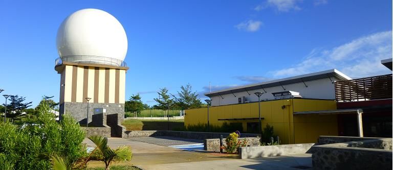
Figure 2: View of the technical buildings
and the antenna under radome
31Images Received and Processed by the SEAS-OI Station
2012-2013 2013-2014 2014-2015 Received Processed
SPOT 4 & 5 6,990 10,543 3,862 21,395 9,190
RADARSAT 2 95 93 90 278 278
Total 7,095 10,636 3,952 21,673 9,468
32You can also read