CERT/ENG/140602/4405 LIVERPOOL JOHN LENNON AIRPORT RNAV (GNSS)
←
→
Page content transcription
If your browser does not render page correctly, please read the page content below
LIVERPOOL JOHN LENNON AIRPORT RNAV (GNSS)
                             APPROACHES
                                               OPERATIONAL REPORT

                                       CERT/ENG/140602/4405
                                              ISSUE 1

                                                                                        Produced for ATCSL by
                                                                                        Certisa International Ltd
                                                                                        3000 Hillswood Drive
                                                                                        Chertsey
                                                                                        Surrey
                                                                                        KT16 0RS
                                                                                        www.certisa.com

                                                                                        Certisa is ISO9001:2008 certified for the production of
                                                                                        safety assurance documentation by Bureau Veritas

©2015 ATCSL, Certisa. All rights reserved. The information contained within this document must not be disclosed, copied or reproduced in whole or
in part without prior written permission from ATCSL and Certisa. Distribution of this document shall only be as stated in Table 1 unless otherwise
agreed by ATCSL and Certisa.

                   Please consider the environment before printing this document. This document has been formatted to be printed double sided
                   which significantly reduces paper usage and transportation emissions. For full details please see www.certisa.com/environment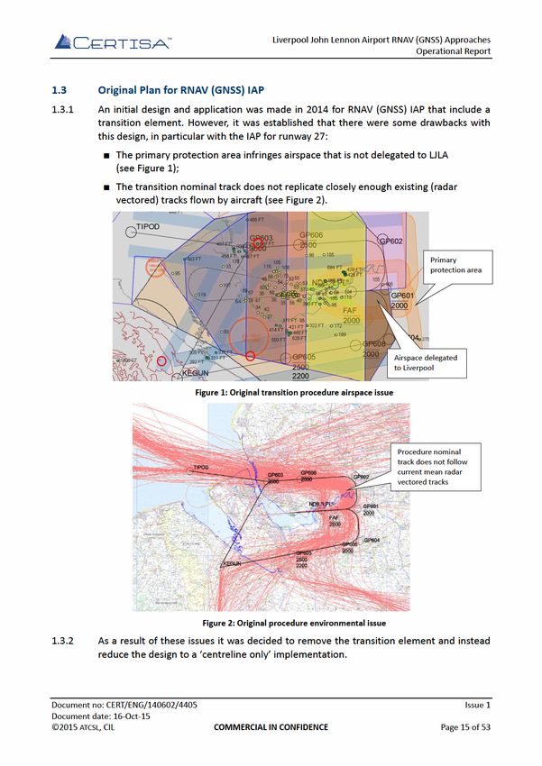
Liverpool John Lennon Airport RNAV (GNSS) Approaches
                                                                                   Operational Report

                                      INTENTIONALLY BLANK

Document no: CERT/ENG/140602/4405                                                             Issue 1
Document date: 16-Oct-15
©2015 ATCSL, CIL                    COMMERCIAL IN CONFIDENCE                             Page 2 of 53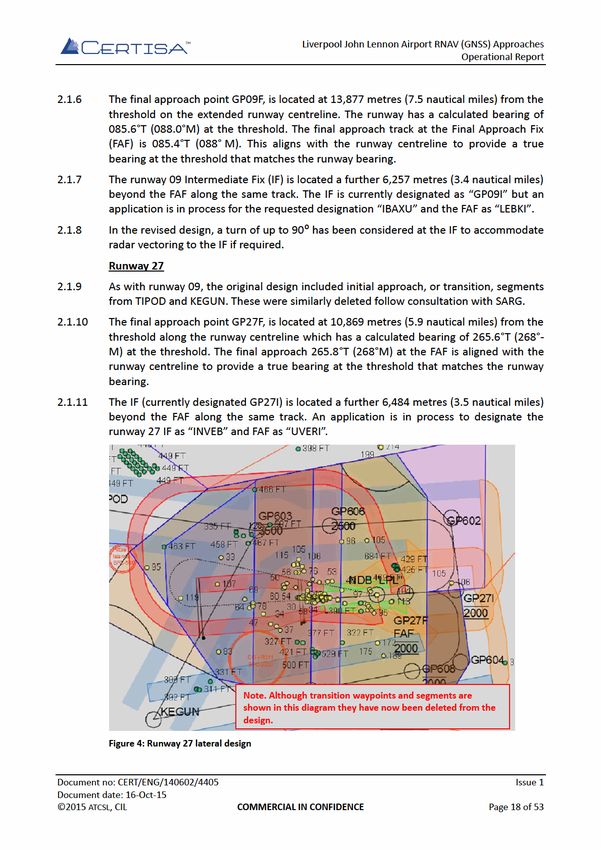
Liverpool John Lennon Airport RNAV (GNSS) Approaches
                                                                                     Operational Report

                                    Document Approval

           Authored by:                                                   15 October 2015
                                               Mike Rothon
                                         Certisa International Ltd

           Reviewed by:                                                   16 October 2015
                                                 Jessica Lu
                                         Certisa International Ltd

           Approved by:                                                   16 October 2015
                                               Leon Gilmour
                                      Air Traffic Control Services Ltd

Document no: CERT/ENG/140602/4405                                                                Issue 1
Document date: 16-Oct-15
©2015 ATCSL, CIL                    COMMERCIAL IN CONFIDENCE                                Page 3 of 53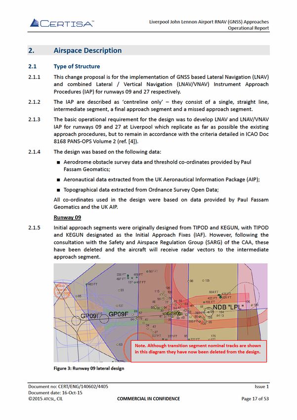
Liverpool John Lennon Airport RNAV (GNSS) Approaches
                                                                                                          Operational Report

Table of Contents
Document Approval ................................................................................................................... 3
Executive Summary .................................................................................................................... 9
Project Key Points .................................................................................................................... 10
1. Justification for Change and Change Options ..................................................................... 12
  1.1 Background .......................................................................................................................... 12
  1.2 Options Considered ............................................................................................................. 14
  1.3 Original Plan for RNAV (GNSS) IAP ...................................................................................... 15
  1.4 Justification for RNAV (GNSS) Baro VNAV ........................................................................... 16
2. Airspace Description ......................................................................................................... 17
  2.1 Type of Structure ................................................................................................................. 17
  2.2 Comparison with Existing ILS IAP ........................................................................................ 19
  2.3 Hours of Operation .............................................................................................................. 20
  2.4 Connectivity to En-route Structures .................................................................................... 20
  2.5 Airspace Buffer Requirements ............................................................................................. 20
  2.6 Forecast Usage..................................................................................................................... 22
  2.7 Letters of Agreement / Memoranda of Understanding ...................................................... 25
  2.8 Design Compliance with ICAO SARPs .................................................................................. 26
  2.9 Airspace Classification and Delegations .............................................................................. 28
3. Supporting Infrastructure and Resources ........................................................................... 29
  3.1 Navigation and Surveillance Infrastructure ......................................................................... 29
  3.2 Communication Infrastructure ............................................................................................ 30
  3.3 Aerodrome Infrastructure ................................................................................................... 31
  3.4 Equipment Failures .............................................................................................................. 31
  3.5 SSR Code Assignment .......................................................................................................... 33
  3.6 Staffing Levels and Qualifications ........................................................................................ 33
4. Operational Impact ........................................................................................................... 35
  4.1 Overview.............................................................................................................................. 35
  4.2 General Aviation .................................................................................................................. 35
  4.3 Visual Flight Rules Operations ............................................................................................. 36
  4.4 Effects on Other Procedures and Capacity .......................................................................... 36
     4.4.1 Existing Routes ............................................................................................................. 36
     4.4.2 Single European Sky / CAA Future Airspace Strategy .................................................. 36
     4.4.3 Northern Terminal Control Area .................................................................................. 38
  4.5 Other Aerodromes and Other Activities ............................................................................. 40
  4.6 Flight Planning or Route Restrictions .................................................................................. 40
5. Economic Impact .............................................................................................................. 42
6. Safety Management .......................................................................................................... 43
7. Airspace Infrastructure Requirements ............................................................................... 45
  7.1 Overview.............................................................................................................................. 45
  7.2 Support of Separation ......................................................................................................... 45
  7.3 Performance and Failures .................................................................................................... 46
  7.4 General Considerations ....................................................................................................... 46
  7.5 Relation to ATS Routes......................................................................................................... 47

Document no: CERT/ENG/140602/4405                                                                                                     Issue 1
Document date: 16-Oct-15
©2015 ATCSL, CIL                                    COMMERCIAL IN CONFIDENCE                                                    Page 5 of 53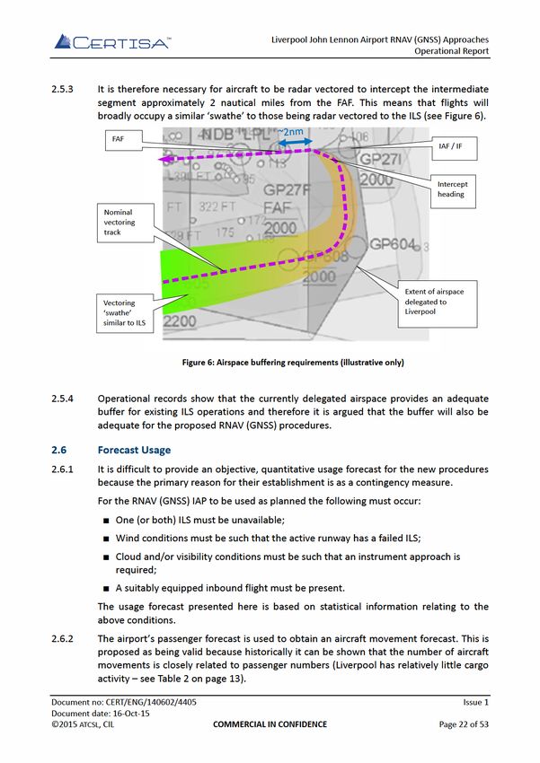
Liverpool John Lennon Airport RNAV (GNSS) Approaches
Operational Report
7.6 Additional Requirements for Terminal Airspace ................................................................. 48
7.7 Additional Requirements for Off-Route Airspace Structures .............................................. 49
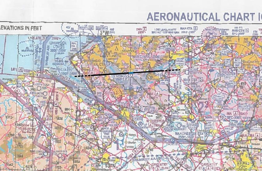
8. Supporting Maps Charts and Diagrams .............................................................................. 50
8.1 Instrument Approach Procedure Design ............................................................................. 50
8.2 Design Package .................................................................................................................... 50
Figures
Figure 1: Original transition procedure airspace issue ...................................................................... 15
Figure 2: Original procedure environmental issue ............................................................................. 15
Figure 3: Runway 09 lateral design .................................................................................................... 17
Figure 4: Runway 27 lateral design .................................................................................................... 18
Figure 5: Liverpool CTA and delegated airspace overview................................................................. 21
Figure 6: Airspace buffering requirements (illustrative only) ............................................................ 22
Figure 7: Aircraft Movement Forecast 2015 – 2019 .......................................................................... 23
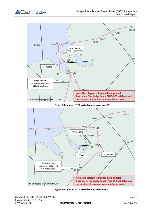
Figure 8: Proposed NTCA arrival routes to runway 09 ....................................................................... 39
Figure 9: Proposed NTCA arrival routes to runway 27 ....................................................................... 39
Figure 10: Overlay of centrelines on CAA 1:500 000 VFR chart ......................................................... 51
Document no: CERT/ENG/140602/4405 Issue 1
Document date: 16-Oct-15
©2015 ATCSL, CIL COMMERCIAL IN CONFIDENCE Page 6 of 53Liverpool John Lennon Airport RNAV (GNSS) Approaches
Operational Report
Acronyms
ACP Airspace Change Proposal
ANSP Air Navigation Service Provider
ATC Air Traffic Control
ATCB Air Traffic Control Building
CAA Civil Aviation Authority
CAP Civil Aviation Publication
CAT Commercial Air Transport
CCO Continuous Climb Operations
CDA Continuous Descent Arrivals
CTA Control Area
FAF Final Approach Fix
FAT Final Approach Track
FMS Flight Management System
GNSS Global Navigation Satellite System
HAZID Hazard Identification
IAP Instrument Approach Procedure
ICAO International Civil Aviation Organisation
IF Intermediate Fix
IFP Instrument Flight Procedure
ILS Instrument Landing System
LJLA Liverpool John Lennon Airport
LNAV Lateral Navigation
LoA Letter of Agreement
NDB Non-directional Beacon
NTCA Northern Terminal Control Area
PANS-OPS Procedures for Air Navigation Services – Operations
RESA Runway End Safety Area
RNAV Area Navigation
RWY Runway
SARPS Standards and Recommended Practices
SID Standard Instrument Departures
SiS Signal in Space
STAR Standard Arrivals
TMA Terminal Manoeuvring Area
VNAV Vertical Navigation
Document no: CERT/ENG/140602/4405 Issue 1
Document date: 16-Oct-15
©2015 ATCSL, CIL COMMERCIAL IN CONFIDENCE Page 7 of 53Liverpool John Lennon Airport RNAV (GNSS) Approaches
Operational Report
References
[1] CAA Guidance on the Application of the Airspace Change Process, Civil Aviation
Authority, document reference CAP 725.
[2] Liverpool John Lennon Airport, Airport Master Plan to 2030 Part 1, Peel Airports,
2007.
[3] Aviation Policy Framework, Secretary of State for Transport, March 2013, ISBN
9780101858427.
[4] Procedures for Air Navigation Services, Aircraft Operations, Volume 2, Construction
of Visual and Instrument Flight Procedures, International Civil Aviation Organisation,
document reference 8168 OPS/611.
[5] Proposal for PBN Instrument Flight Procedures – Liverpool Airport (EGGP), Davidson
Ltd, document reference 20150624EGGP.
[6] Future Airspace Strategy Deployment Plan, Level 1, The FAS Industry
Implementation Group, December 2012.
[7] Liverpool John Lennon Airport RNAV (GNSS) Approaches Safety Case, Certisa
International Ltd, document reference CERT/ENG/140602/4301.
[8] Guidance on the Conduct of Hazard Identification, Risk Assessment and the
Production of Safety Cases: For Aerodrome Operators and Air Traffic Service
Providers, Civil Aviation Authority, document reference CAP 760.
[9] CAA website, Introduction to Bowtie and Significant Seven Bow-Tie templates
www.caa.co.uk/bowtie.
[10] Compliance with ICAO SARPS for RNAV GNSS Instrument Approach Procedures
supporting LNAV and LNAV/VNAV, Civil Aviation Authority.
[11] Liverpool John Lennon Airport RNAV (GNSS) Approaches Validation Plan and Report,
Certisa International Ltd, document reference CERT/ENG/140602/4501.
[12] Policy Statement – Validation of Instrument Flight Procedures, CAA Directorate of
Airspace Policy, June 2009.
[13] Global Navigation Satellite System (GNSS) Approaches – Training Plan, ATCSL,
October 2015.
[14] Policy Statement – Special Use Airspace – Safety Buffer for Airspace Design
Purposes, August 2014.
[15] Liverpool John Lennon Airport, Air Traffic Control Manual of Air Traffic Services Part
2, ATCSL, 2015.
[16] Guidance to the Civil Aviation Authority on Environmental Objectives Relating to the
Exercise of its Air Navigation Functions, Department of Transport, 2014.
[17] Supplementary Instruction XX/2016, GNSS (RNAV) Approaches, ATCSL, document
reference to be defined.
[18] ATS Safety Manual, ATCSL, document reference VATS/VATS/ATS/SMS/002, March
2014.
Document no: CERT/ENG/140602/4405 Issue 1
Document date: 16-Oct-15
©2015 ATCSL, CIL COMMERCIAL IN CONFIDENCE Page 8 of 53Liverpool John Lennon Airport RNAV (GNSS) Approaches
Operational Report
Executive Summary
Air Traffic Control Services Ltd (ATCSL) are the Air Navigation Service Provider (ANSP) for Liverpool
John Lennon Airport (LJLA). Certisa have been tasked by ATCSL to support the implementation of
new Global Navigation Satellite System (GNSS) based Area Navigation (RNAV) Instrument Approach
Procedures (IAP) for both runways at LJLA.
As the name implies, GNSS IAP use satellite navigation technology to provide aircraft flight path
guidance. This technology reduces the cost of the required ground infrastructure and therefore has
an advantage over conventional, ground-based systems such as Instrument Landing System (ILS)
and Non Directional Beacon (NDB). Furthermore, GNSS RNAV can facilitate more efficient and
flexible use of airspace.
Changes to airspace and flight routings in the UK are governed by the process described in Civil
Aviation Publication (CAP) 725 and changes require the formal submission of an Airspace Change
Proposal (ACP).
An ACP is normally initiated by the ANSP, the airport operator or both. In the ACP process the
initiator is referred to as the ‘sponsor’ of the change. For this project the airport operator –
Liverpool Airport Ltd (LAL) are sponsoring the change but have delegated the majority of the
change process to ATCSL.
Stage 1 of the ACP is the opportunity of the change sponsor to meet with the Civil Aviation
Authority (CAA) and discuss the change proposal early in the process within a ‘Framework
Briefing’. An initial Framework Briefing took place 28 May 2015, however it was quickly clear that
the planned consultation process was inadequate for the scope of the change. This was because
the proposed transition element of the procedure design would cause a noticeable change to
aircraft flight paths.
Following the initial Framework Briefing it was decided to change the scope of the IAP design such
that there is no longer a transition element. The new ‘centreline only’ design will allow Liverpool
Air Traffic Control (ATC) to continue to provide radar vectors to aircraft in a similar way to the
existing IAP meaning that the difference to current flight tracks is minimal. The practicality of the
revised approach was confirmed during a second Framework Briefing on 16 July 2015.
This document provides an Airspace Change Proposal – Operational Report for the introduction of
the new procedures. The purpose of this document is to provide a summary of the objective
evidence that has been established to support the proposal, including:
A demonstration that the new RNAV approaches replicate as closely as possible the designs
for the existing ILS IAP and that adverse environmental effects have been minimised;
Evidence that a robust stakeholder consultation process is has taken place and has involved
Local Authorities, special interest groups, ATC and airspace users;
The design has been produced by an Approved Procedure Designer (APD) and is ready for
review;
The original designs have been validated by EasyJet in a full-flight simulator, a flyability
assessment has been performed by Ravenair and an Air Traffic Control (ATC) assessment
has been completed by Liverpool ATC.
Document no: CERT/ENG/140602/4405 Issue 1
Document date: 16-Oct-15
©2015 ATCSL, CIL COMMERCIAL IN CONFIDENCE Page 9 of 53Liverpool John Lennon Airport RNAV (GNSS) Approaches
Operational Report
Project Key Points
The following table provides a very short overview and some key points about the project.
Background and justification for Liverpool currently operates Instrument Landing System (ILS)
change: precision approaches to both ends of a single runway.
Airlines and aircraft operators are fitting approach capable
GNSS receivers to their fleets.
There is an emerging global trend to use GNSS as a primary or
secondary instrument approach system.
Any outage of the glidepath or localiser transmitters at LJLA
will result in a non-precision approach with higher minima
and the risk of diversions, holds and delays leading to loss of
revenue and confidence by users.
Design summary: Two new Lateral Navigation (LNAV) with Vertical Navigation
(VNAV) GNSS approaches have been proposed. The VNAV
component is based on barometry (Baro VNAV).
Each design begins at its respective IF located 3.4 / 3.5
nautical miles on an extended centreline from the FAF. The
intermediate segment connects the IF and FAF. The RNAV FAF
and final approach segment replicate the ILS FAF and final
approach segment.
Impact on airspace users: The procedures provide an additional option to operators
when selecting an instrument approach. The procedures also
provide the ability to continue operations in the event of an
outage of the conventional equipment.
LJLA do not believe that there will be any noticeable negative
impacts on airspace users. However LJLA are very willing to
understand any concerns identified during consultation.
Environmental aims: It is a project objective that the environmental impacts
resulting from this change shall be kept to an absolute
minimum.
Consultation plan: Stakeholders will be notified of the IAP design and presented
with information explaining the nature of the change and its
effect on traffic flows and patterns.
Consultation will consist of information packs and response
forms. These will be sent to Local Authorities whose areas of
responsibility lay below the intermediate and final approach
segments. Local air operators, adjacent Air Traffic Service
(ATS) units and other aviation groups will also be consulted.
The consultation will run for a 12-week period. LJLA will
carefully consider all stakeholder responses and make
changes or otherwise address any concerns raised.
Document no: CERT/ENG/140602/4405 Issue 1
Document date: 16-Oct-15
©2015 ATCSL, CIL COMMERCIAL IN CONFIDENCE Page 10 of 53Liverpool John Lennon Airport RNAV (GNSS) Approaches
Operational Report
Adjoining States: No impacts are foreseen on airspace arrangements with
adjoining states as a result of this change.
European Airspace Liverpool will be affected by the planned Northern Terminal
Programmes: Control Area (NTCA) airspace change and the implementation
of Continuous Climb Operations (CCO) and Continuous
Descent Arrivals (CDA).
The new LNAV/VNAV procedures may therefore maybe
adapted to integrate with new Standard Instrument Arrival
(STAR) procedures.
Status and comments: A preliminary design exists for the RNAV (GNSS) IAP.
A Notification of Intended Airspace Change Proposal or
Procedure Design Activity (form 1916) has been submitted to
the CAA and a Safety Case is being prepared.
This document has been structured in accordance with the suggested Operational Report contents listed
within CAP 725 Appendix A.
Document no: CERT/ENG/140602/4405 Issue 1
Document date: 16-Oct-15
©2015 ATCSL, CIL COMMERCIAL IN CONFIDENCE Page 11 of 53Liverpool John Lennon Airport RNAV (GNSS) Approaches
Operational Report
1. Justification for Change and Change Options
1.1 Background
1.1.1 LJLA is an international airport serving the city of Liverpool and the broader North-West
region of England. LJLA is located 6 nautical miles to the south east of Liverpool city
centre on the northern banks of the Mersey Estuary.
1.1.2 Liverpool Airport first opened officially in 1933 on the old northern airfield site at Speke
which is now the successful Liverpool International Business Park. The current runway
was completed in 1966 but the airport continued to use the old terminal for passengers
until the 1980’s when it was converted into the Crown Plaza Hotel.
1.1.3 The airport’s neighbours include the residential communities of Speke to the north and
Hale Village, within the Borough of Halton, to the east. To the north west, LJLA borders
Liverpool International Business Park (on the site of the former airfield) and the grounds
of Speke Hall which is a National Trust property with a significant number of visitors.
Further to the north are the communities of Garston and Allerton. To the south,
between the runway and the estuary, is agricultural land known as ‘the Oglet’. A new
control tower and radar installation are situated within the Oglet and are accessed
separately from the main site. To the west of the airport and to the south of the Oglet
are several kilometres of unpopulated tidal estuary.
1.1.4 LJLA was for a time one of the fastest growing airports in Europe, with passenger
numbers increasing from just under 689,500 in 1997 to just under 5.5 million in 2007.
Following the financial crisis and other pressures, passenger numbers have decreased
and now stand at just under 4 million per annum.
1.1.5 The following table provides some basic facts about LJLA.
Aspect Details
Runway dimensions 2285 x 46 metres
Airspace Liverpool Air Traffic Zone (ATZ) 2.5 nautical miles radius
(Class D)
Liverpool Control Zone (CTR) (Class D) (see Figure 1)
Air Traffic Service (ATS) Liverpool Radar/Approach (H24)
Communication Liverpool Tower (H24)
Liverpool Ground (by ATC)
ATIS
Radar Separation Minima 3 nautical miles / 5 nautical miles
Table 1: Background information
Document no: CERT/ENG/140602/4405 Issue 1
Document date: 16-Oct-15
©2015 ATCSL, CIL COMMERCIAL IN CONFIDENCE Page 12 of 53Liverpool John Lennon Airport RNAV (GNSS) Approaches
Operational Report
1.1.6 The following table provides some further statistical information:
Statistic Value
(2014 unless stated)
Terminal Passengers 3.984 million
UK ranking (by passenger numbers) 13
Freight (tonnes) 236
UK ranking (by tonnes freight) 25
Commercial Air Transport Movements 30,789
General Aviation / Other Movements 21,460
Total movements 52,249
Number of instrument approaches runway 09 6,411
Number of instrument approaches runway 27 10,651
Total duration ILS 09 unavailable (excluding 981 minutes
schedule maintenance) (Availability 99.826%)
(Jun 2014 – June 2015)
Total duration ILS 27 unavailable (excluding 15 minutes
schedule maintenance) (Availability 99.997%)
(Jun 2014 – June 2015)
Table 2: Background statistics
1.1.7 LJLA is situated 20 nautical miles west of Manchester Airport. With such close proximity
there is inevitably a degree of competition between the two airports. The LJLA Master
Plan (ref. [2]) therefore includes the primary objectives of:
■ Developing the airport to provide affordable access for business and leisure
travellers;
■ Complementing the Port of Liverpool to create opportunities for multimodal freight
transportation.
Consequently, it is important that the LJLA provides a safe, reliable and economically
attractive offering to airlines and air operators.
Document no: CERT/ENG/140602/4405 Issue 1
Document date: 16-Oct-15
©2015 ATCSL, CIL COMMERCIAL IN CONFIDENCE Page 13 of 53Liverpool John Lennon Airport RNAV (GNSS) Approaches
Operational Report
1.2 Options Considered
Prior to deciding on the proposed RNAV (GNSS) with Barometric Vertical Navigation
(Baro-VNAV) design, LJLA considered a number of different options. The following table
summarises the options considered along with a short discussion as to why they were
discounted in favour of the design proposed in this document.
No. Option Discussion
1 Do nothing Some elements of the existing ILS, DME and NDB navigation
aids are approaching the end of their useful lives.
Therefore, the equipment may suffer from more frequent or
extended periods of unserviceability and more frequent
maintenance interventions.
Such events may impair the operational capability of LJLA,
potentially resulting in passenger inconvenience, increased
costs for air operators, reduced revenues, increased fuel
burn and CO2 emissions.
2 Implement The original ATC operational requirement was for an
RNAV(GNSS) ‘overlay’ of the existing NDB procedure.
LNAV NDB This option was discounted during preliminary consultation
overlay with a key airspace user (easyJet) because a LNAV/VNAV
design offers vertical guidance and a lower Decision Altitude
(DA).
3 Implement This option was initially the preferred option and was
RNAV(GNSS) considered in detail. A summary of this initial option is
LNAV/VNAV provided in section 1.3.
with full However, once the design had been completed it became
transition clear that there were some significant drawbacks such as
the proximity to Manchester airspace and a change in
nominal flightpaths when compared with the current
situation.
4 Replace all This option would require a very significant investment by
existing ILS, the airport operator and could impact on the ability to
DME and NDB achieve the stated objective (ref. [2]) to provide affordable
equipment access for business and leisure travellers.
Furthermore, this option does not provide the flexibility of
adding a RNAV (GNSS) option or resilience in the event of
maintenance or unserviceability.
5 Implement During the initial airline discussions, it was highlighted that
RNAV(GNSS) easyJet (one of main airlines at LJLA) aircraft are currently
with SBAS VNAV Baro-VNAV equipped but not SBAS equipped.
Therefore SBAS is a less preferable option.
Table 3: Options considered
Document no: CERT/ENG/140602/4405 Issue 1
Document date: 16-Oct-15
©2015 ATCSL, CIL COMMERCIAL IN CONFIDENCE Page 14 of 53Liverpool John Lennon Airport RNAV (GNSS) Approaches
Operational Report
1.4 Justification for RNAV (GNSS) Baro VNAV
1.4.1 All current IAP at LJLA rely on ground based navigational aids, specifically ILS and NDB.
An increasing number of aircraft are equipped with GNSS based RNAV equipment that
allows Performance Based Navigation (PBN) procedures to be flown.
1.4.2 A key advantage of RNAV (GNSS) procedures is that they do not require expensive
ground navigation equipment, but the technology also provides more accurate guidance
than NDB which can potentially lead to improvements in safety.
1.4.3 The proposed designs include a VNAV component (Baro-VNAV) which mean that pilots
are provided with vertical and horizontal guidance.
1.4.4 For now, LJLA are committed to maintaining the existing ground based navigation aids.
Therefore, the RNAV (GNSS) IAP will provide a contingency option available to pilots of
suitably equipped aircraft and allow continued operations in the event of ILS
unavailability.
1.4.5 The CAA is leading the development of a Future Airspace Strategy (FAS) for the UK. A
subpart of the FAS is the development of the Northern Terminal Control Area (NTCA).
One of the key advantages of the NTCA will be the ability for aircraft to perform
Continuous Climb Operations (CCO) and Continuous Descent Operations (CDO), these
reduce fuel burn and CO2 emissions.
1.4.6 It is understood that the CDO in the NTCA will be PBN derived (ref. [3]). The proposed
GNSS (RNAV) IAP have the potential to interface to the PBN / CDO STAR that are being
considered as part of the NTCA design. A side-effect of the decision to remove the
transition element of the procedures is that the currently proposed IAP could possibly
be connected to a NTCA STAR with only minor changes.
1.4.7 In summary, the implementation of the RNAV (GNSS) procedures is justified because:
■ RNAV (GNSS) provides a contingency for occasions when the ground based
navigation aids are unavailable;
■ Adding RNAV (GNSS) IAP provides greater flexibility to airspace users;
■ RNAV (GNSS) is potentially more accurate than older NDB technology. When
combined with Baro-VNAV, RNAV (GNSS) IAP provide both lateral and vertical
guidance to pilots.
1.4.8 Furthermore, the implementation of the RNAV (GNSS) at Liverpool is consistent with the
FAS strategy because it:
■ Is aligned with the UK/Ireland Functional Airspace Block (FAB) aspirations of
developing P-RNAV and progressing to Advanced Required Navigational
Performance (A-RNP);
■ Reduces reliance on ground-based navigation aids;
■ Supports the development of (A-)RNP arrival procedures.
Document no: CERT/ENG/140602/4405 Issue 1
Document date: 16-Oct-15
©2015 ATCSL, CIL COMMERCIAL IN CONFIDENCE Page 16 of 53Liverpool John Lennon Airport RNAV (GNSS) Approaches
Operational Report
2.2 Comparison with Existing ILS IAP
The following tables provide a comparison of key elements between the new RNAV (GNSS) IAP and the
existing ILS IAP.
Runway 09
Element RNAV (GNSS) IAP ILS IAP
STAR to IAP transition Self-positioning or ATC radar DME arc or ATC radar vectors to
(normal operations) vectors to IF or to intercept intercept extended centreline
extended centreline
IF bearing to THR 088°M (extended centreline) N/A
IF distance to THR 10.9 nautical miles N/A
IF altitude 2500 feet AMSL N/A
FAF bearing to THR 088°M (extended centreline) 088°M (extended centreline)
FAF distance to THR 7.5 nautical miles 7.5 nautical miles
FAF altitude 2500’ AMSL 2500’ AMSL
GP gradient 3° 3°
OCA 360’ (CAT A – D) 205’ (CAT A) / 241’ (CAT D)
Missed approach Straight ahead to LPL and hold Straight ahead to LPL and hold
climbing 2500’ climbing 2500’
Table 4: Comparison between RNAV and ILS IAP runway 09
Runway 27
Element RNAV (GNSS) IAP ILS IAP
STAR to IAP transition ATC radar vectors to intercept ATC radar vectors to intercept
(normal operations) extended centreline extended centreline
IF bearing to THR 268°M (extended centreline) N/A
IF distance to THR 9.4 nautical miles N/A
IF altitude 2000 feet AMSL N/A
FAF bearing to THR 268°M (extended centreline) 268°M (extended centreline)
FAF distance to THR 5.9 nautical miles 5.9 nautical miles
FAF altitude 2000’ AMSL 2000’ AMSL
GP gradient 3° 3°
OCA 390’ (CAT A – D) 229’ (CAT A) / 263’ (CAT D)
Missed approach Straight ahead to 1500’ then Straight ahead to 1500’ then
right to LPL climbing 2000’ right to LPL climbing 2000’
Table 5: Comparison between RNAV and ILS IAP runway 27
Document no: CERT/ENG/140602/4405 Issue 1
Document date: 16-Oct-15
©2015 ATCSL, CIL COMMERCIAL IN CONFIDENCE Page 19 of 53Liverpool John Lennon Airport RNAV (GNSS) Approaches
Operational Report
2.3 Hours of Operation
2.3.1 Liverpool ATS and all associated airspace is operational H24. The new RNAV (GNSS) IAP
will also be available H24, but they are primarily intended for use when the ILS is
unavailable. Pilots wishing to use the RNAV (GNSS) IAP must make a request to this
effect on first contact with Liverpool ATC.
2.3.2 Although it is intended that the new IAP are provided for contingency use, there is no
current plan for Liverpool ATC to refuse a request for a RNAV (GNSS) approach, even
though the ILS is available. This is for two reasons:
1. The minima for the RNAV procedures is higher than that for the equivalent ILS
procedure. In anything other than moderate to good weather conditions, it is
expected that pilots will naturally prefer the ILS procedure when it is available;
2. The RNAV final approach path is essentially identical to that of the equivalent ILS
final approach path. Therefore, it is expected that any differences, in environmental
or any other terms, between the two IAP will be almost imperceptible.
2.4 Connectivity to En-route Structures
2.4.1 The IAP do not interact directly with en-route structures. Aircraft will be vectored under
radar control from existing Standard Arrival Routes (STAR) to intercept the intermediate
segment of the IAP.
2.4.2 The radar vectoring of aircraft to the RNAV (GNSS) IAP is almost identical to the existing
procedure for the ILS, however potentially greater consideration will be given to
providing aircraft with sufficient stabilisation distance.
2.4.3 Pilots may alternatively self-position for runway 09. In this case Liverpool ATC will issue a
clearance for the procedure, with an instruction to report at the IF (IBAXU). Self-
positioning for runway 27 will not be permitted.
2.5 Airspace Buffer Requirements
2.5.1 The following description of the Liverpool Control Zone (CTR) and Figure 5 on the
following page have been extracted from the Liverpool Manual of Air Traffic Services
(ref. [15]) (MATS) Part 2, Section 1, Chapter 2. They are reproduced here to provide the
reader with a general overview of the operational environment and constraints on the
IAP design.
The Liverpool CTR lies below the western portion of the Manchester CTA and extends up
to 2500 ft. AMSL. It is notified as Class D Airspace and subject to rules which specify
weather criteria. A pilot wishing to fly within the CTR is required to obtain prior
permission to do so, and comply with other procedures as laid down in Rule 27.
The Liverpool CTA extends from 2500ft to 3500ft AMSL to the west of a line north / south
through the airport reference point. Further west the CTA extends from 1500ft to 3500ft.
This creates an overland route for GA traffic around the Wirral via Wallasey up to
1500ft.
Document no: CERT/ENG/140602/4405 Issue 1
Document date: 16-Oct-15
©2015 ATCSL, CIL COMMERCIAL IN CONFIDENCE Page 20 of 53Liverpool John Lennon Airport RNAV (GNSS) Approaches
Operational Report
Continuing west there are 8nm long portions of Class D airspace coincident with L10 and
L975 (Class A) extending up to 3500ft and designated as Liverpool CTA. The base levels of
Airways L10 and L975 in this area are 3500ft.
Further Class D airspace delegated to Liverpool by Prestwick Centre (PC W2) is as
follows:
■ Delegated Area A to 4000ft;
■ Delegated Area C to 3000ft;
■ The part of Delegated Area D which is above the LLC to 2500ft;
■ Delegated Area E to 2000ft above the LLC;
■ Delegated Area F to 2500ft above the LLC.
The airspace delegated to Liverpool by PC (W2) can be used by all traffic working
Liverpool, including VFR traffic in the areas of class D airspace. However, when
Manchester traffic is operating on runway 05, co-ordination must be agreed with
Manchester approach before Liverpool ATC can clear an aircraft to enter the portions of
area C and D which are south of the Liverpool centreline at an altitude above two
thousand feet AMSL or any part of area E. The only exception to this would be aircraft
carrying out the standard missed approach procedure for runway 09.
Figure 5: Liverpool CTA and delegated airspace overview
2.5.2 As discussed in section 1.3 above, the proximity of Manchester airspace to the east of
the runway 27 IAP does not provide an adequate buffer for the primary protection areas
for a standard T-bar style design. This is a particularly important consideration in
relation to aircraft manoeuvring for runway 27 from the south west.
Document no: CERT/ENG/140602/4405 Issue 1
Document date: 16-Oct-15
©2015 ATCSL, CIL COMMERCIAL IN CONFIDENCE Page 21 of 53Liverpool John Lennon Airport RNAV (GNSS) Approaches
Operational Report
2.6.3 During the 1980’s and early 1990’s, passenger numbers were approximately 500,000 per
year. 1997 saw the start the first real growth at Liverpool for decades, initially with the
opening of routes by easyJet and later by Ryanair. The current terminal was built in
2001/2 and the airport was re-branded “Liverpool John Lennon Airport”.
2.6.4 The period between 2002 and 2008 witnessed rapid growth with passenger numbers
increasing to a peak of approximately 5.8 million. The global financial crisis of 2008
dramatically reduced air travel and at the same time Manchester Airport introduced
low-cost operations. This has resulted in a year-on-year decline in passenger numbers
until 2014 which saw approximately 4 million passengers.
2.6.5 There are now signs of a general strengthening of the economy, furthermore Liverpool
City and the broader catchment area is becoming an increasingly attractive destination.
The airport now has a mature marketing strategy that offers key differentiators against
its competitors, most noticeably Manchester Airport. It is therefore reasonable that the
airport’s planners are expecting passenger numbers to recover, potentially to the 2008
levels in the next 5 years.
It should be emphasised that the growth in traffic forecast is entirely due to economic
and market reasons. It is in no way a consequence of introducing the RNAV (GNSS)
procedures (but see also section 5).
2.6.6 Although there is a strong correlation between passengers and aircraft movements,
there are other aspects – for example passenger load factors and aircraft size – that can
influence the exact relationship between the two. The airport’s best estimate is
therefore that Commercial Air Transport (CAT) movements will return to pre-crisis levels
by 2019 (see Figure 7).
Figure 7: Aircraft Movement Forecast 2015 – 2019
Document no: CERT/ENG/140602/4405 Issue 1
Document date: 16-Oct-15
©2015 ATCSL, CIL COMMERCIAL IN CONFIDENCE Page 23 of 53Liverpool John Lennon Airport RNAV (GNSS) Approaches
Operational Report
2.6.7 This yields the following approximate figures for forecast aircraft movements by 2019:
■ 48,000 commercial aircraft movements per year;
■ 70,000 total movements per year.
Or in other words a 43% increase compared with 2014. This figure can be used to
extrapolate the number of instrument approaches given in Table 2 (which have been
taken directly from Liverpool ATC records) up until 2019:
■ 9,200 IAP forecast for runway 09 per year;
■ 15,200 IAP forecast for runway 27 per year.
2.6.8 It can also be seen from Table 2 that the worst case unavailability for ILS equipment at
Liverpool is somewhat less than 0.2%, and the ILS for runway 27 is an order of
magnitude more reliable. Even applying the runway 09 ‘worst case’1 figures for both
runways, this would imply that the forecast numbers of aircraft needing to use the RNAV
(GNSS) procedure would be as follows:
■ 18 RNAV (GNSS) IAP needed for runway 09 per year by 2019 (upper bound);
■ 30 RNAV (GNSS) IAP needed for runway 27 per year by 2019 (upper bound).
2.6.9 Informal discussions with Liverpool-based airlines, charter operators and flying schools
indicate that the RNAV (GNSS) procedures will also be requested for training and
currency purposes. Any quantitative estimate for the above is subjective by nature,
however it was indicated that between 1/20 and 1/10 of IAP requested might be for a
RNAV (GNSS). Taking the latter figure it could be concluded that the upper bound for
RNAV (GNSS) requests is as follows:
■ 900 RNAV (GNSS) IAP requested for runway 09 per year (upper bound);
■ 1,500 RNAV (GNSS) IAP requested for runway 27 per year (upper bound).
It is worth noting that this represents approximately 3.7% of all movements.
2.6.10 Airline operators currently using Liverpool have some of the youngest and best
equipped fleets of aircraft in the world. Similarly, considering that Liverpool is a
reasonably large international airport, any GA aircraft arriving under IFR are likely to be
equipped to a relatively high standard – including RNAV capability. Therefore, it is not
foreseen that there will be a skewing of the current ratio between CAT and GA IAP due
to the introduction of the new procedures.
2.6.11 There is a minor ATC workload increase in that controllers will need to maintain currency
on supporting both ILS and RNAV (GNSS) IAP. The RNAV (GNSS) IAP for runway 27 is also
slightly more complex from a controller perspective because:
1
The runway 09 ILS unavailability is mostly due to unscheduled maintenance on the localiser. There is a capital plan to
procure a new localiser in 2016 so it is anticipated that there should be a marked improvement and unavailability of
both ILS will be closer to the current runway 27 figure. Therefore, the usage figures are considered ‘upper bounds’.
Document no: CERT/ENG/140602/4405 Issue 1
Document date: 16-Oct-15
©2015 ATCSL, CIL COMMERCIAL IN CONFIDENCE Page 24 of 53Liverpool John Lennon Airport RNAV (GNSS) Approaches
Operational Report
■ Pilots will not necessarily be monitoring the I-LQ DME whilst downwind, which
requires greater attention on the part of both pilots and controllers to ensure
aircraft remain within the Liverpool delegated airspace2;
■ Some airlines require a 2 nautical mile stabilisation distance prior to the FAF. This
may require slightly more accurate positioning by the controller to ensure the
aircraft intercepts the intermediate segment appropriately.
2.6.12 It was demonstrated during the ATC validation activities (ref. [11]) that the workload
increase is minor and well within the capacity of Liverpool controllers.
2.7 Letters of Agreement / Memoranda of Understanding
2.7.1 There are no new Letters of Agreement (LoA) or Memoranda of Understanding (MoU)
arising as a result of the new RNAV (GNSS) IAP.
2.7.2 As part of the implementation process, ATCSL has reviewed the current LoA to ensure
that there is no impact on any current agreements. This has been confirmed as follows:
2
This point was considered during the HAZOP and suitable mitigations proposed (see ref. [7]).
Document no: CERT/ENG/140602/4405 Issue 1
Document date: 16-Oct-15
©2015 ATCSL, CIL COMMERCIAL IN CONFIDENCE Page 25 of 53Liverpool John Lennon Airport RNAV (GNSS) Approaches
Operational Report
Table 6: Review of existing LoA.
2.8 Design Compliance with ICAO SARPs
2.8.1 The procedure design has been performed by Davidson Ltd (DAL) who are an Approved
Instrument Flight Procedure (IFP) Design Organisation. The DAL approval was granted by
the CAA as described in CAP 785.
Document no: CERT/ENG/140602/4405 Issue 1
Document date: 16-Oct-15
©2015 ATCSL, CIL COMMERCIAL IN CONFIDENCE Page 26 of 53Liverpool John Lennon Airport RNAV (GNSS) Approaches
Operational Report
2.8.2 The RNAV (GNSS) IAP have been designed in accordance with the criteria laid down in
International Civil Aviation Organisation (ICAO) Document 8168 Volume 2, Procedures
for Air Navigation Services Aircraft Operations (PANS-OPS) Construction of Visual and
Instrument Flight Procedures. An independent validation of the design has been carried
out by .
2.8.3 The basis for the Flexible Use of Airspace (FUA) concept is that airspace should not be
designated as either military or civil airspace but should be considered as a single
continuum. Where possible any necessary airspace segregation should be temporary in
nature and optimisation of network performance will always be of primary
consideration. The application of the FUA concept aims to ensure that, through the
daily allocation of flexible airspace structures, any necessary segregation of airspace is
based on real usage within a specific time period and airspace volume. Details of the UK
policy on FUA are contained with CAP 740.
2.8.4 ATCSL believe that the introduction of the new IAP fall under Airspace Management
(ASM) Level 1 (Strategic). The introduction of the new procedures is broadly in
accordance with the basis of the FUA because RNAV (GNSS) is a forward-looking
technology that is at the root of both civil and military aviation. Furthermore, this
technology supports integration into the more flexible structure that is being planned as
part of the Northern Terminal Control Area (NTCA), see section 4.4 for details.
2.8.5 A full flight validation process was conducted for the original RNAV 09, RNAV 27 and
RNAV 27 alternate procedures (including transitions) on 17 February 2015. The
validation was conducted in accordance with the Validation Plan and Results (ref. [11])
which has been prepared to satisfy the requirements of the CAA Policy Statement on the
Validation of Instrument Flight Procedures (ref. [12]).
2.8.6 The validation was performed by EasyJet / CAE using a full motion A320 simulator. In
order to realistically evaluate the procedure a special database was encoded for the
simulator’s Honeywell Flight Management System (FMS).
2.8.7 Overall the procedure design was given the maximum score of 9 out of 9 against the
criteria of “General impression of the procedure”. There were no adverse observations
and only three comments. Two of the comments related to the initial / transition
segments of the procedure and are therefore no longer relevant. The remaining
comment relates to the hold design as follows:
“The hold speed of 185 kts at LPL Non-directional Beacon (NDB) requires holding with
slats extended on an A320 which leads to higher fuel consumption. Airbus recommends
that slats are not extended during holding in icing conditions. It is recommended that the
hold is reviewed.”
2.8.8 The easyJet evaluation was based on the full procedure, however it has been agreed
with SARG that the results of this evaluation are acceptable for the centreline only
designs. easyJet have also confirmed that their aircraft equipment is able to ‘capture’ a
GNSS approach profile from a radar vectored intercept.
Document no: CERT/ENG/140602/4405 Issue 1
Document date: 16-Oct-15
©2015 ATCSL, CIL COMMERCIAL IN CONFIDENCE Page 27 of 53Liverpool John Lennon Airport RNAV (GNSS) Approaches
Operational Report
2.8.9 The hold is based on the existing hold for the ILS and NDB approaches. It is of course
possible to design a new hold for the RNAV procedures, but this hold is only practically
used in the event of a radio failure and LJLA would like to avoid a change that may result
in any negative environmental impact. The hold design has subsequently been discussed
and accepted by easyJet.
2.8.10 A further validation assessment has been conducted by Ravenair in a PA-34 Seneca light
twin-engine aircraft. The assessment was also conducted in accordance with the
documented Validation Plan and Results (ref. [11]). The primary objective of the
Ravenair assessment was to establish the controllability and flyability of radar vectoring
to intercept the IAF – FAF segment. The flights also validated the flyability of the
procedure in a GA aircraft and visually validate obstacle and terrain clearance. As with
the easyJet, the Ravenair assessment confirmed the flyability of the design although
some errors were noted on the specimen approach plates.
2.9 Airspace Classification and Delegations
2.9.1 There is no reclassification of airspace required for the new GNSS IAP. The new IAP fall
entirely within the Liverpool CTR and airspace delegated within the Manchester
CTR/CTA. The Liverpool CTR and the Manchester CTR/CTA are both Class D airspace, this
provides suitable protection for aircraft operating under IFR.
2.9.2 Access to the new RNAV (GNSS) IAP will be available to all suitably equipped airspace
users in the same manner as the current ILS IAP. Indeed, it is possible that in the future
RNAV (GNSS) technology may become available to a broader spectrum of airspace user
than current conventional technology.
2.9.3 The new procedures have been deliberately designed to mimic as closely as possible the
existing ILS designs and therefore their impact on all other airspace users should be
negligible.
2.9.4 No aspect of the Liverpool ATS is being delegated and no new delegations are being
sought by Liverpool as a result of this change. Details of the extant delegations are
summarised in sections 2.5 and 2.7.
Document no: CERT/ENG/140602/4405 Issue 1
Document date: 16-Oct-15
©2015 ATCSL, CIL COMMERCIAL IN CONFIDENCE Page 28 of 53Liverpool John Lennon Airport RNAV (GNSS) Approaches
Operational Report
3. Supporting Infrastructure and Resources
3.1 Navigation and Surveillance Infrastructure
3.1.1 The proposed change is designed to operate seamlessly with the current conventional
navigation infrastructure at Liverpool. The new RNAV (GNSS) IAP are being primarily
implemented as a contingency measure for use in the event of ILS or DME unavailability.
3.1.2 There are no plans to decommission the existing ILS equipment which will remain
operational. In fact, there is a capital plan allocated with the 2016 budget to replace the
runway 09 Localiser (LOC) with new equipment.
3.1.3 The LPL Non Directional Beacon (NDB) is normally required to be in operation for an
aircraft to fly a RNAV (GNSS) procedure because it provides the primary guidance for the
radio failure missed approach procedure.
3.1.4 Similarly, aircraft will only be able to use the RNAV (GNSS) IAP when Liverpool radar
surveillance is operational. This is because of the need to vector aircraft to intercept the
intermediate segment and also to monitor conformance to the final approach path.
3.1.5 Liverpool ATC are equipped with an on-aerodrome Raytheon ASR 10SS Primary
Surveillance Radar (PSR).
3.1.6 Liverpool are also provided with Onward Routed Radar Data (ORRD) from NATS
Secondary Surveillance Radar (SSR) sensors
Document no: CERT/ENG/140602/4405 Issue 1
Document date: 16-Oct-15
©2015 ATCSL, CIL COMMERCIAL IN CONFIDENCE Page 29 of 53Liverpool John Lennon Airport RNAV (GNSS) Approaches
Operational Report
3.1.8 The live flight trials performed by Liverpool ATC and Ravenair verified the
interoperability and suitability for use of the current navigation / surveillance equipment
in conjunction with the RNAV (GNSS) IAP.
3.1.9
3.1.10
3.2 Communication Infrastructure
3.2.1 The RNAV GNSS IAP are within the same volume of airspace as the existing ILS IAP.
Therefore, the adequacy of R/T coverage is demonstrated through the satisfactory
operational record of the existing equipment and compliance with the relevant
regulatory requirements of CAP 670 for radiotelephony equipment.
3.2.2
3.2.3
3.2.4
Document no: CERT/ENG/140602/4405 Issue 1
Document date: 16-Oct-15
©2015 ATCSL, CIL COMMERCIAL IN CONFIDENCE Page 30 of 53Liverpool John Lennon Airport RNAV (GNSS) Approaches
Operational Report
3.3 Aerodrome Infrastructure
3.3.1 The RNAV procedures are based on the existing ILS procedures for runways 09 and 27.
The procedure for runway 09 is a category 1 (CAT I) ILS whilst runway 27 has the higher
precision category 2 (CAT II) ILS.
3.3.2 The aerodrome regularly reviews compliance with CAP 168 criteria and has 4 variations
approved. The variations are documented on form 10G/28/95/1 and are:
1. 2 small penetrations of the protected surfaces;
2. A reduced Runway End Safety Area (RESA), although this will be addressed following
the installation of a new runway 09 localiser;
3. The absence of centreline lighting on the Western Apron taxiway.
3.4 Equipment Failures
3.4.1 A Hazard and Operability (HAZOP) study (ref. [7]) considered all foreseeable failures and
their effects.
3.4.2
3.4.3
3.4.4
3.4.5
3.4.6
Document no: CERT/ENG/140602/4405 Issue 1
Document date: 16-Oct-15
©2015 ATCSL, CIL COMMERCIAL IN CONFIDENCE Page 31 of 53Liverpool John Lennon Airport RNAV (GNSS) Approaches
Operational Report
3.4.7
Document no: CERT/ENG/140602/4405 Issue 1
Document date: 16-Oct-15
©2015 ATCSL, CIL COMMERCIAL IN CONFIDENCE Page 32 of 53Liverpool John Lennon Airport RNAV (GNSS) Approaches
Operational Report
3.5 SSR Code Assignment
There is no change required to the SSR code assignment at Liverpool. Therefore, the
code assignments remain as follows:
Code (range) Usage
Table 7: SSR code allocation
3.6 Staffing Levels and Qualifications
3.6.1 It was established during the ATC validation exercise that there is no significant increase
in ATC workload resulting from the introduction of the new procedures.
3.6.2 The staffing levels at Liverpool will therefore remain unchanged as follows:
Licensed Personnel Staff Level
Table 8: ATC staffing levels
3.6.3 A detailed training plan and syllabus has been created (ref. [13]). Training is currently
scheduled to take place from 1 February to 26 February 2016 and will be provided to
both Approach rated and Aerodrome rated controllers.
3.6.4
Document no: CERT/ENG/140602/4405 Issue 1
Document date: 16-Oct-15
©2015 ATCSL, CIL COMMERCIAL IN CONFIDENCE Page 33 of 53Liverpool John Lennon Airport RNAV (GNSS) Approaches
Operational Report
3.6.5
3.6.6
Document no: CERT/ENG/140602/4405 Issue 1
Document date: 16-Oct-15
©2015 ATCSL, CIL COMMERCIAL IN CONFIDENCE Page 34 of 53Liverpool John Lennon Airport RNAV (GNSS) Approaches
Operational Report
4.2.4 A wide variety of General Aviation operators and representative bodies were consulted
on the proposal through the NATMAC framework. No negative responses were received,
with all comment being either neutral or broadly in favour.
4.3 Visual Flight Rules Operations
4.3.1 The new IAP reside entirely within the existing Liverpool CTR and closely follow the
existing ILS procedures. Therefore, there is little or no anticipated impact on traffic flow
in or through the area.
4.3.2 There are a number of Visual Reporting Points (VRP) established within the CTR.
Although there are no notified VFR crossing routes, there are a number of regularly used
routes described in the MATS Part 2 (ref. [15]). There are no changes to VRP or the
nominal crossing routes as a result of the introduction of the RNAV (GNSS) procedures.
4.3.3 The Liverpool / Manchester Low Level Corridor is established to the east of Liverpool
Airport and provides a corridor of uncontrolled airspace between Oulton Park in the
south and Kirkby in the north. The new RNAV (GNSS) procedure designs have fully
considered the presence of this corridor and provide adequate separation from VFR
traffic operating within it.
4.4 Effects on Other Procedures and Capacity
4.4.1 Existing Routes
4.4.1.1 Liverpool has 10 published SID and 11 published STAR procedures. Although there is a
published direct arrival from TIPOD to the runway 09 ILS procedure, the standard
published routing for the existing IAP is from the end point of each STAR to the LPL NDB.
From LPL all conventional IAP consist of an outbound leg with a reversal to intercept the
final approach track.
4.4.1.2 In practice, nearly all instrument traffic is radar vectored directly from the STAR to the
final approach track. This will also be the case for the RNAV (GNSS) IAP, however for the
new approaches there is no procedural method, and therefore RNAV (GNSS) will only be
available when the radar service is operational.
4.4.1.3 No discernible effect is anticipated on either the capacity or usage of the existing routes
and holds. This is because the RNAV (GNSS) will normally only be used either as a
contingency for when the ILS is unavailable, or possibly as an alternative to the ILS when
crew currency training is required. The same volume of traffic will continue to use the
existing routes and holding patterns because only the final approach is affected by the
type of IAP (not the arrival or departure routes).
4.4.2 Single European Sky / CAA Future Airspace Strategy
4.4.2.1 The CAA has been working since 2009 to develop a Future Airspace Strategy (FAS) for
the period up to 2030. The CAA’s primary objective is to develop a “safe, efficient
airspace that has the capacity to meet reasonable demand, balances the needs of all
users and mitigates the impact of aviation on the environment”.
Document no: CERT/ENG/140602/4405 Issue 1
Document date: 16-Oct-15
©2015 ATCSL, CIL COMMERCIAL IN CONFIDENCE Page 36 of 53Liverpool John Lennon Airport RNAV (GNSS) Approaches
Operational Report
4.4.2.2 The FAS aligns with UK commitments under the Single European Sky (SES) legislation,
including implementation of the SES Air Traffic Management Research (SESAR)
programme and the creation of an Anglo-Irish Functional Airspace Block (FAB).
4.4.2.3 Following development and consultation with industry, the FAS was presented in June
2011 and set out the need to address:
■ Existing pressures on airspace;
■ The challenges arising from future air traffic growth;
■ The development and implementation of new technology;
■ The requirement to mitigate aviation’s impact on the environment.
4.4.2.4 The FAS Industry Implementation Group launched its plan in 2012 for delivering Phase 1
of the FAS up to 2025. A considerable component of the plan is the need to redesign UK
terminal airspace to make it more efficient. PBN is seen as a key enabler for improving
efficiency. In their December 2013 interim report, the Airports Commission expressed
their support for the FAS and the introduction of PBN.
4.4.2.5 The Department for Transport (DoT) Guidance to the Civil Aviation Authority on
Environmental Objectives Relating to the Exercise of its Air Navigation Functions (ref.
[16]) summarises parts of the FAS and the Airport Commission’s interim report. It has
the following comments on the advantages of PBN:
■ PBN provides enhanced navigational accuracy;
■ PBN reduces the amount of ground-based navigational-related infrastructure
needed;
■ PBN allows for a safer and more efficient ATC system requiring less controller
intervention;
■ PBN allows more efficient aircraft operations leading to less cost, flying time and
emissions;
■ PBN provides the ability to allow more predicable patterns of over flight as well as
stabilised arrivals and approaches which can generate less noise.
4.4.2.6 The DoT guidance then concludes:
“When combined, these benefits will enable a significant improvement to be made to
the overall efficiency and capacity of the UK airspace network which will allow the
sustainable development of the air traffic network to accommodate future traffic levels.”
“The move to PBN will require the updating of existing route structures such as Standard
Instrument Departures (SIDs), Standard Terminal Arrival Routes (STARS) and Instrument
Approach Procedures (IAPs). Updating individual routes in terminal areas can fall into
one of two categories: "replication" where the existing route alignment is preserved as
much as possible whilst catering for the greater navigational accuracy of PBN, or
"redesign" where seeking to optimise the introduction of PBN will require consideration
of a different alignment.”
Document no: CERT/ENG/140602/4405 Issue 1
Document date: 16-Oct-15
©2015 ATCSL, CIL COMMERCIAL IN CONFIDENCE Page 37 of 53You can also read