Chair 'Hydrology for Resilient City': high-resolution urban water management - D. Schertzer Local Authorities Meeting - RainGain

Page created by Ron Ortega
 
CONTINUE READING
Chair 'Hydrology for Resilient City': high-resolution urban water management - D. Schertzer Local Authorities Meeting - RainGain
Chair ‘Hydrology for
    Resilient City’:
 high-resolution urban
  water management
          D. Schertzer

Local Authorities Meeting
        23/10/13
Chair 'Hydrology for Resilient City': high-resolution urban water management - D. Schertzer Local Authorities Meeting - RainGain
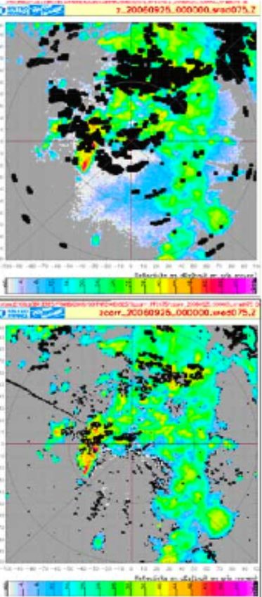
Ecole des Ponts ParisTech

                               • Formerly Ecole Nationale des
                                 Ponts et Chaussées (“National School
                                 of Bridges and Roads”)
                                  – one of the world’s oldest Civil Engineering
                                    School (1747)
                                  – Belgrand, Cauchy, Carnot, Coriolis, Darcy,
                                    Navier, Saint-Venant...
                               • last decades
                                  – beyond its more traditional fields and into
                                    an international institution,
                                  – adapting to the changing demands of the
                                    modern world
                                     • cofounder of the ParisTech cluster and
                                        Paris-Est University
                                     • teaching complex systems,
                                        multifractals, etc. to young generations
                                        of engineers and managers
ERS view of the Amazon basin
Chair 'Hydrology for Resilient City': high-resolution urban water management - D. Schertzer Local Authorities Meeting - RainGain
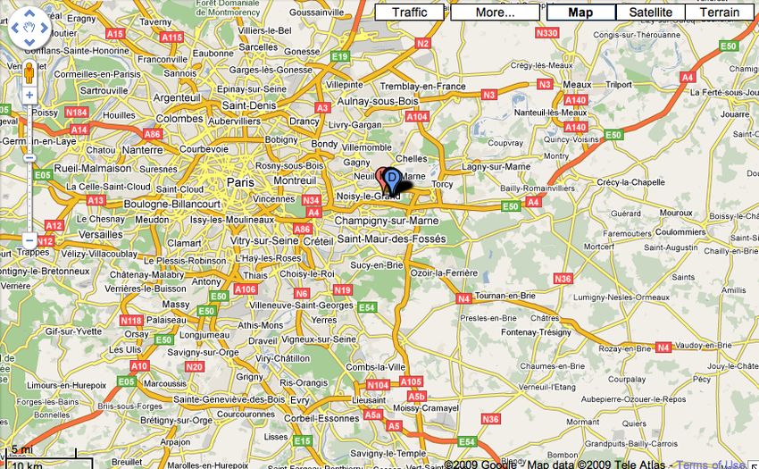
Chair “Hydrology for
   Resilient Cities”
• Partners
  Ecole des Ponts, Fondation des Ponts, VEOLIA EAU
• Duration: 10 ans, 30/08/10 - 31/12/20
• General goal
  to develop within an international framework
    around École des Ponts ParisTech, and in
    relation with VEOLIA and its subsidies, a
    cutting edge research and education on
    Hydrology for Resilient Cities
Chair 'Hydrology for Resilient City': high-resolution urban water management - D. Schertzer Local Authorities Meeting - RainGain
Urbanisation is going on…
                                  • Extreme vulnerabilty of
                                    our urban and mobility
                                    systems to extreme
                                    weather conditions
                • European Union
                  directives:
                   – « live with floods »
                   – « back to good
                     ecological state »

    Transition from risk
    management to
    resilient systems

4
Chair 'Hydrology for Resilient City': high-resolution urban water management - D. Schertzer Local Authorities Meeting - RainGain
…in the context of climate change
       •   How to achieve resilient cities and mobility?
       •   Which strategies of reduction/adaptation to climate change?
       •   How to downscale climate scenarios to relevant scales?

      Agreement of models on a         but disagreement on the evolution
      temperature increase…            of precipitation extremes
5
Chair 'Hydrology for Resilient City': high-resolution urban water management - D. Schertzer Local Authorities Meeting - RainGain
A	
  Trillion	
  Dollar	
  Challenge	
  !
                  STERN REVIEW: The Economics of Climate Change

Figure 3 Illustrative emissions paths to stabilise at 550ppm CO2e.

The figure below shows six illustrative paths to stabilisation at 550ppm CO2e. The rates of emissions
cuts given in the legend are the maximum 10-year average rate of decline of global emissions. The
figure shows that delaying emissions cuts (shifting the peak to the right) means that emissions must be
reduced more rapidly to achieve the same stabilisation goal. The rate of emissions cuts is also very
sensitive to the height of the peak. For example, if emissions peak at 48 GtCO2 rather than 52 GtCO2 in
2020, the rate of cuts is reduced from 2.5%/yr to 1.5%/yr.

                                          70

                                          60
              Global Emissions (GtCO2e)

                                          50

                                          40

                                          30

                                                 2015 High Peak - 1.0%/yr
                                          20     2020 High Peak - 2.5%/yr
                                                 2030 High Peak - 4.0%/yr
                                                 2040 High Peak - 4.5%/yr (overshoot)
                                          10     2020 Low Peak - 1.5%/yr
                                                 2030 Low Peak - 2.5%/yr
                                                 2040 Low Peak - 3.0%/yr
                                          0
                                          2000       2020            2040           2060   2080   2100

Source: Reproduced by the Stern Review based on Meinshausen, M. (2006): 'What does a 2°C target
mean for greenhouse gas concentrations? A brief analysis based on multi-gas emission pathways and
several climate sensitivity uncertainty estimates', Avoiding dangerous climate change, in H.J.
Schellnhuber et al. (eds.), Cambridge: Cambridge University Press, pp.265 - 280.
6
Chair 'Hydrology for Resilient City': high-resolution urban water management - D. Schertzer Local Authorities Meeting - RainGain
Light and versatile radars
      for urban hydrology?

                                                        X-band radar
                                                       (FRAMEA, Provence)
     S-band radar
     (Marshall Observatory, U. McGill),

                                             close-up remote sensing
                                             of precipitation ?
7                              (NIED mobile X-band radars)
Chair 'Hydrology for Resilient City': high-resolution urban water management - D. Schertzer Local Authorities Meeting - RainGain
Space resolution increase with
           X -band radar

                                                                (Maki et al., 2009)

           a= 1.5 C1= 0.2 H = 0.1
                                    a= 1.5 C1= 0.2 H = 0.1

                                                               Snapshots of a
                                                               multifractal rain
                                                               fall simulation
                                                               with resolutions
                                                                  = 16, 128
                                                             ↵ = 1.5, C1 = .2, H = .1

8
Chair 'Hydrology for Resilient City': high-resolution urban water management - D. Schertzer Local Authorities Meeting - RainGain
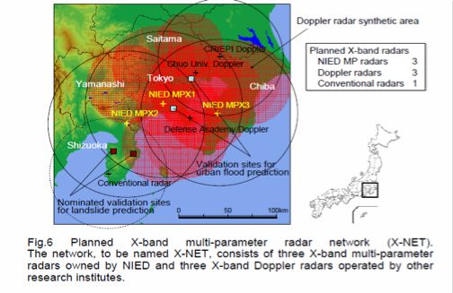
Self-calibration of polarimetric
                        radars

          Why not to
Radar S   use PhiDP?
          (see Testud et al.)

Radar X
           Ground clutter (black) comparison between S and X-
           band radars, (Tabary et Eideliman, 2007)
9
Chair 'Hydrology for Resilient City': high-resolution urban water management - D. Schertzer Local Authorities Meeting - RainGain
RainGain

            o http://www.raingain.eu
            o Sites: Leuwen, London, Paris,
              Rotterdam
            o Objective: to improve fine-scale
              measurement and prediction of
              rainfall and to enhance urban pluvial
              flood prediction in order to enable
              urban water managers to adequately
              cope with intense storms, so that the
              vulnerability of populations and critical
              infrastructure can be reduced.
            o Budget: 7 M€
10
RadX@IdF: Ile-de-France Council
                                   RadX@IdF
                                support
                                                    Circles of 10, 20, and 30 km,
                                                    centered on PST Paris-East            Cercles de rayons
                                                                                          10, 20 et 30 km
                                                                                           • Objectives
                                                                                          centrés  sur Paris-
                                                                                          Est (portée
                                                                                                – develop
                                                                                                      en R&D
                                                                                                  synergies
                                                                                          mesure de          on
                                                                                                    l’ordre de
                                                                                          50 km) higher
                                                                                                     resolution
                                                                                                     rainfall
                                                                                                     measurement
                                                                                                     and prediction
                                                                                           •   Budget
                                                                                                 –   1.2 M€

Déjà un complémentAindispensable
                        complementary       radar
                                      pour l’Est     to thepar
                                                  Parisien    Meteo-France     C-band
                                                                 rapport au radar        radar
                                                                                  classique     of Trapes (SW)
                                                                                            de Trappes
(nombreux masques, lais already
                      hauteur       mesure croît avec la distance)… mais avec une résolution 10 fois supérieure!
                              de laindispensable.
                                                          16
 11
TOMACS
                                                                                    MRI C-band Solid-
    Ku-band Fast Scan MP                                                            state MP Radar    MTSAT
    Radar
                                                                                                      Rapid Scan

                                                           2DVD Radar
                                                           Calibration site
                                                                                        X-NET
                                                                                        (NIEDS and cooperative org.)

                                                                    Scintillation                   JMA Operation
    Doppler Lidars
                                                   Dense Surface    Meter                           Doppler Radars
                                                   Network

                                                                              JMA Lightning
                                                                              Detection Systems
                     Microwave
                                                                                                         Wind Profilers
                     radiometers
                                   GPS Receivers
                                                      Radiosonde

        Humid Warm Air                                                                            Relatively Cool Air

A field campaign in the Tokyo metropolitan area with a dense observation network is
conducted by MRI, NIED and 12 research institutions in the summers 2011-2013, as a testbed
                                                                                    16
for deep convection.                12
Tokyo	
  X-­‐Net

                     MP-X3

               JWA

                           CRIEP
     YMNS      CHUO

            MP-X1         MP-X2

                    NDA

                    0        50    100km

                                           10
13
X-band radar networks

                       Similar
                       plans for
                       9 major
                       towns

14
CASA
                   IP1: X'band Radar Network
        IP1:%Integrated%Project%1,%the%first%system7level%test7bed,%
        developed%and%operated%in%the%DCAS%paradigm

      IP1 test bed:
     the first DCAS
     radar network

      Southwestern
                  OK
         ~ 7000 km2
      4 radar nodes
             X-band
                Dual-
15       polarization
Republic of Korea:
     Weather Information Service Engine(WISE)

The objective of the project is
to develop the WISE platform in order to produce more accurate,
detailed and customized weather information services.

 The goal of the project is
 to better understand the micro scale phenomenon through observation,
In order to develop multi scale, multiple modeling system and micro
observation system, especially in the boundary layer.

 In order to reach these goals,
International cooperation, communication and integration
with related field is needed.

                                                    16
technique of Yeaulieu et alT 6GRRw:T

                           Bilateral collaborations

                                              – Bureau of Meteorology,
                                                Melbourne, AU
                                              – Auckland U., NZ
                                              – McGill U., Montréal, CA
                                              – Iowa U. Iowa City, USA
                                              – UC Davis & UC SB, USA
                                              – IME, Rio de Janeiro, BR
                                              – UNL, Santa Fe, AR
                                              – EPFL, Lausanne, SW
   A                                          – ETZH, Zurich, SW
                                              – ...
  GSI et frontogenesis in STEP (Seed et al., 2013)
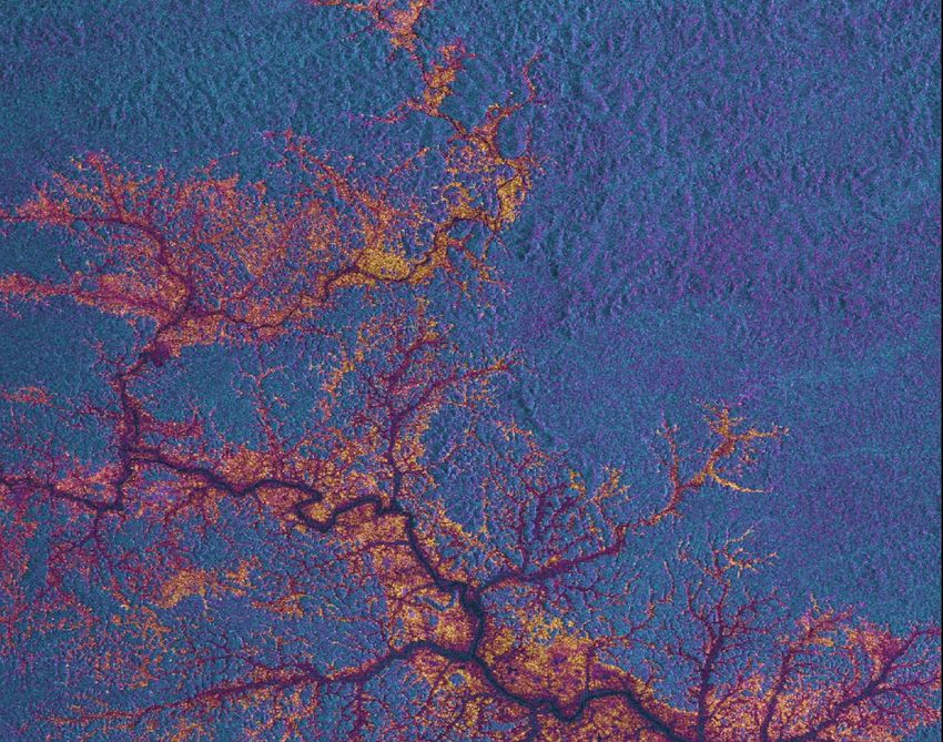
  17 RTM   RTG   RT9   M    G     9    MR
Conclusion: complexity and heterogeneity
    of the precipitation as a challenge!

     Art piece ‘Windswept’ (Ch. Sowers, 2012, courtesy of        Multifractal FIF simulation (Schertzer et
     G. Fitton): 612 freely rotating wind direction indicators   al., 2013) of a 2D+1 cut of wind and its
     to help a large public to understand the complexity of      vorticity (color). This stochastic model
     environment near the Earth surface                          has only a few parameters that are
                                                                 physically meaningful.
Both movies illustrate the challenge of the near surface wind that plays a key
role in the heterogeneity of the precipitations... under active investigation !
18
You can also read