The Impacts of Sea Level Rise on Maui's Shorelines
←
→
Page content transcription
If your browser does not render page correctly, please read the page content below
UNIHI-SEAGRANT-GG-13-02

       The Impacts of Sea Level Rise on Maui’s Shorelines
      A Briefing Prepared for: Organizing For Action and the Hawaiian Islands Land Trust
     for the Climate Awareness Event at the Waihee Coastal Dunes and Wetlands Refuge

                                          Prepared By:
                            Tara Owens, University of Hawaii Sea Grant

                                          August 2013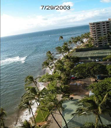
Global and Local Sea Level Trends
From a global perspective, the instrumental record of modern sea level change shows onset of
rising sea levels during the 19th century i. During the 20th century, global average sea level rose at a
rate of about 1.7 mm/yr (about 7 in/century). Since 1993, satellite observation data has shown
sea level to be rising at a rate of about 3 mm/yr (about 12 in/century). Coastal tide gage
measurements confirm this record, and also show that sea levels do not rise uniformly around the
world. Global sea level rise is projected to accelerate during the 21st century, with current
projections of 3-9 inches by 2030, 7-18 inches by 2050, and 19-55 inches by 2100 ii. Sea level rise is
now widely acknowledged by the U.S. Government with projected ranges of 8 inches to 6.6 feet by
the year 2100 iii,iv.

In the Hawaiian Islands, rates of local (relative) sea level rise vary with distance from Hawaii Island
because of differences in lithospheric flexure (island subsidence) from the weight of actively
growing volcanoes v. Measurements of
sea level rise over the past century from
NOAA tide gages show that Hawaii
Island’s localized rate of sea level rise is
3.27 ± 0.35 mm/yr vi (about 13
inches/century). The next closest island,
Maui Island, has a rate of sea level rise
at 2.32 ± 0.53 mm/yr (about 9
in/century). Sea level is rising roughly
65% slower around Kauai and Oahu, at Sea level rise varies with distance from the island of Hawaii. Source: Moore
                                              (1987) and NOAA tide gage network.
1.53 ± 0.59 mm/yr and 1.50 ± 0.25
mm/yr (about 6 inches/century), respectively. Unlike global records, accelerated sea level rise has
not yet been detected in the Hawaii tide gage records vii,viii.

Sea Level Rise and Coastal Erosion Trends
The Maui Shoreline Atlas provides maps of coastal erosion based on trends in the positions of
historical shorelines. The shoreline positions, and associated erosion rates, reflect rising sea levels
that have been measured at NOAA’s tide gage in Kahului Harbor. A recent update of the Atlas
data, as well as the 2012 National Assessment of Shoreline Change report for the Hawaiian
Islands ix, indicate that at least 85% of Maui beaches are exhibiting erosion with 11% of beaches
completely lost to erosion. Further, Maui’s erosion rates are highest compared to the islands of
Oahu and Kauai, probably in part due to higher rates of local sea level rise. Another study
indicates that sea level rise has been an important factor in historical shoreline change in Hawaii,
and that historical rates of shoreline change are about two orders of magnitude greater than sea
level rise x.
August 2013                                                                                         P a g e |1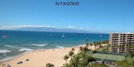
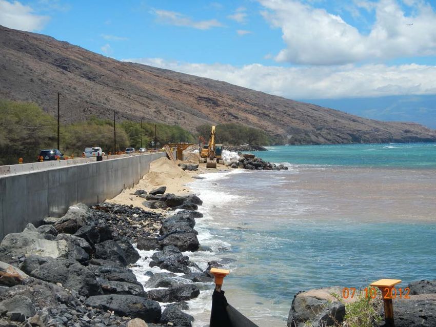
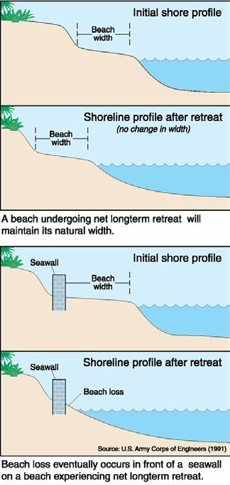
It is still unclear at exactly what scale and timeframe the Hawaiian Islands will experience
accelerated sea level rise. It is also difficult to predict exactly how shorelines will respond.
However, there are already analogs in Hawaii for the type of erosion impacts that can be
expected. On Maui, the erosion experienced in Kaanapali in the summer of 2003 is one example.
That summer, short-term increases in sea level were experienced as mesoscale eddies (large

 An analog on Maui for the impact of sea level rise on coastal erosion is the beach
 erosion that occurred at Kaanapali Beach during the summer of 2003 due to short-
 term elevated sea levels along with a sustained south swell. Photo credit: Hyatt
 Regency Maui Resort.

rotating water masses) propagated through the islands.
These eddies produced tides that were 0.5 ft higher than
normal. The elevated water levels, coupled with a minor south swell, resulted in enough wave
energy traveling alongshore to transport massive amounts of beach sediment to the opposite end
(north) of the beach system. The beach in the resort area disappeared entirely at some locations
and there was high anxiety about possible infrastructure damage. Fortunately, temporary
emergency protection measures were implemented and the beach recovered after a period of
weeks. However, the implication is that a small increase in water level, only 0.5 ft in this case, can
contribute to substantial shoreline retreat.

What’s in Store for the Waihee Refuge and Maui Beaches
The Waihee shoreline is comprised of cobble and sandy beach backed by coastal dunes. Historical
erosion has been light to moderate, up to around 1 ft/yr along some sections. With an additional
3 ft of sea level rise, which may be a conservative planning target, this shoreline and others around
Maui will be affected by higher tides, and erosion rates are likely to accelerate. The exact
response of the beach and dune area will depend on many influences including waves, sediment
supply, geomorphology, and human impacts.

Development pressures make the task of managing shoreline erosion extremely challenging. In
Hawaii, shoreline hardening (seawalls and revetments) has historically been used as a first line of
defense against coastal erosion. However, it is well documented that the practice of shoreline
hardening can result in Ioss of beach, shoreline access, and culturally sensitive lands. Maui has
August 2013                                                                               P a g e |2
discouraged the practice of shoreline hardening in the last two
decades, but shoreline planners are noting increased requests
for seawall repairs and new seawalls. In the face of sea level
rise, it will be important to find alternative management
strategies. Protecting and restoring coastal dunes is an
important strategy because sand dunes provide a variety of
critical ecosystem and cultural services, such as providing a
barrier for protection of development and infrastructure from
high waves and inland flooding; supplying beaches with sand;
filtering pollution from upland runoff; hosting habitat for plant
and animal species that are unique to Hawaii; and serving as
cultural heritage sites. The Waihee Coastal Dunes and Wetlands
Refuge offers land preservation as well a study site for the
impacts of sea level rise, and can serve as a model for response
and adaptation strategies.

A Summary of What We Know
1. Sea Level is rising globally and locally, and rates are expected
   to increase.
2. There is scientific consensus for 1 ft of global sea level rise by
   the year 2050, and 3 ft or more by the year 2100.
3. Increases in sea level will result in increases to local erosion rates and will add pressure to
   already eroding beaches and coasts throughout Hawaii.
4. It is important to implement alternative management strategies (“no regrets” approaches) to
   existing coastal management challenges that will be exacerbated by sea level rise.

i
 IPCC, 2007. Climate Change 2007: The Physical Science Basis. Contribution of Working Group I to the Fourth Assessment Report of
the Intergovernmental Panel on Climate Change [Solomon, S., D. Qin, M. Manning, Z. Chen, M. Marquis, K.B. Averyt, M.Tignor and
H.L. Miller (eds.)]. Cambridge University Press, Cambridge, United Kingdom and New York, NY, USA.

ii
 U.S. National Academy of Sciences, 2012. Sea-Level Rise for the Coasts of California, Oregon, and Washington: Past, Present, and
Future.

iii
      U.S. Army Corps of Engineers, 2011. Sea-level Change Considerations for Civil Works Programs. Circular No. 1165-2-212

iv
  Global Sea Level Rise Scenarios for the United States National Climate Assessment. Dec, 2012. NOAA Technical Report OAR CPO-
1. NOAA Climate Program Office. http://www.cpo.noaa.gov/sites/cpo/Reports/2012/NOAA_SLR_r3.pdf

v
 Moore, J.G., 1987. Subsidence of the Hawaiian Ridge. In: Decker, R.W.; Wright, T.L., and Stauffer, P.H. (eds.). Volcanism in Hawai’i.
Reston, Virginia: U.S. Geological Survey Professional Paper 1350, pp. 85–100.

August 2013                                                                                                            P a g e |3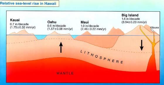
vi
 NOAA (National Oceanic and Atmospheric Administration), 2012. Center for Operational Oceanographic Products and Services.
http://tidesandcurrents.noaa.gov/index.shtml.
vii
       Church, J.A. and White, N.J., 2006. A 20th century acceleration in global sea level rise. Geophysical Research Letters, 33(L01602).
viii
   Merrifield, M.A.; Merrifield, S.T., and Mitchum, G.T., 2009. An anomalous recent acceleration of global sea level rise. Journal of
Climate, 22(21), pp. 5772–5781.
ix
 1 Fletcher, C.H., Romine, B.M., Genz, A.S., Barbee, M.M., Dyer, Matthew, Anderson, T.R., Lim, S.C., Vitousek, Sean,
Bochicchio, Christopher, and Richmond, B.M., 2011. National Assessment of Shoreline Change: Historical
Shoreline Change in the Hawaiian Islands. U.S. Geological Survey Open-file Report 2011-1051, pp. 55.

x
 Romine, B., Fletcher C.H., Barbee,M.M., Anderson, T.R., Frazer, L.N., 2013. Are beach erosion rates and sea-level rise related in
Hawaii? Global and Planetary Change 108, pp. 149-157.

August 2013                                                                                                                 P a g e |4
You can also read