Monitoring and Predicting Irelands Weather and Climate - Making Ireland Weather and Climate Prepared - CMG Events
←
→
Page content transcription
If your browser does not render page correctly, please read the page content below
Making Ireland Weather
          and Climate Prepared

    Monitoring and Predicting Irelands
    Weather and Climate

Evelyn Cusack
Head of Forecasting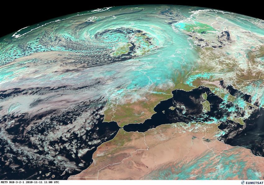
Met Éireann

    Making Ireland Weather and Climate Prepared
• ensure the protection and safety of life and property by issuing public
  weather forecasts and warnings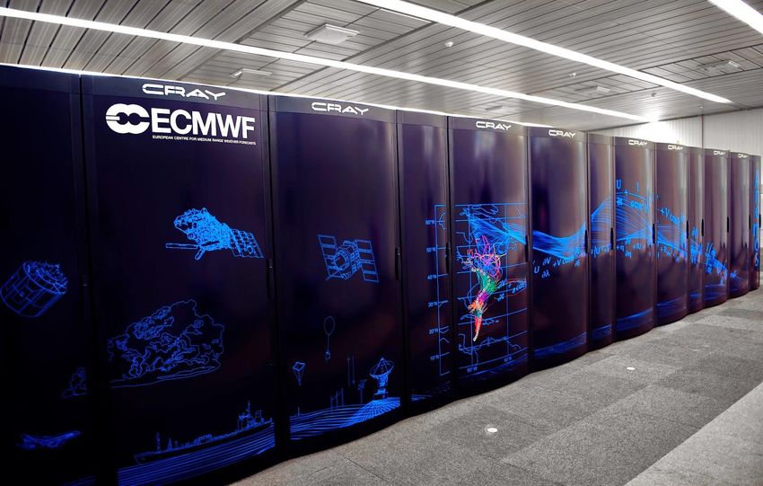
Met Éireann

    Making Ireland Weather and Climate Prepared
• ensure the protection and safety of life and property by issuing public
  weather forecasts and warnings
• Enhance support for impact-based decision making for weather events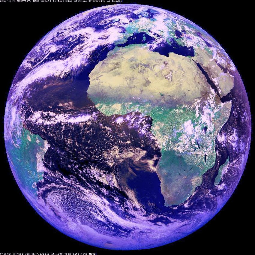
Met Éireann

    Making Ireland Weather and Climate Prepared
• ensure the protection and safety of life and property by issuing public
  weather forecasts and warnings
• Enhance support for impact-based decision making for weather events
• Deliver a high quality national flood forecasting service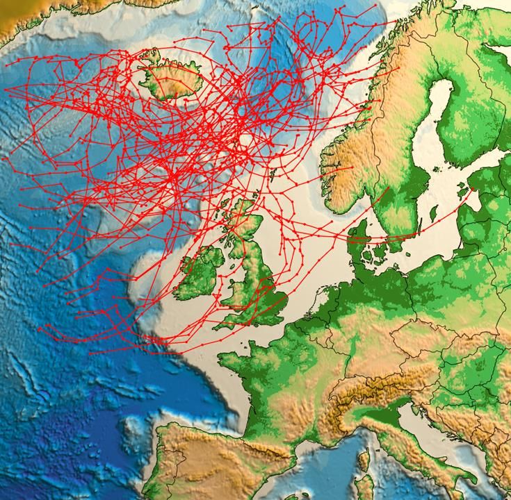
WMO Weather &
Climate Observational
Network
10,000 surface weather stations
1,000 upper-air stations
7,000 ships
100 moored and 1,000 drifting buoys
hundreds of weather radars
3,000 specially equipped commercial aircraft
16 meteorological and 50 research satellites.
Observation Platforms
The Equations of the Atmosphere
ECMWF Global model   MET Éireann HARMONIE model
  9km resolution            2.5km resolution
The ECMWF’s Cray XC30 supercomputer can
perform up to 2 quadrillion calculations a second.

                  https://www.youtube.com/watch?v=txlATLRgA9Q&
                  feature=player_embedded
Highest annual rainfall total: 3964.9mm at Ballaghbeama Gap, Co Kerry in 1960.
Meteosat
Cold air
Snow showers

 Front….rain

         Tropical air mass
         Fog/drizzle/sunny
Spring 2018 ‘The Beast from the East meets Storm Emma’
A Case of Mistaken Identity
    28th October 2013

             St Jude (Weather
               Channel)
             Christian (FU Berlin)
             Allan (DMI)
             Simone (SMHI)
             Carmen (European
               Windstorms Centre)
Storm Naming Rules
West group:UK;
Ireland; Netherlands
South West group:
France;
Spain;
Portugal.Storm Naming Rules • Storm depression (large) • Based on Warnings in the Meteoalarm framework (AMBER/ORANGE or RED ……impact-based and/or thresholds) • NMS which first issues the warning names the Storm in consultation with other partners. • Names picked by NMS’s (public suggestions etc) • It keeps its name given by NHC Miami preceded by ex.
Storm Naming Rules
• Storm depression (large)

• Based on Warnings in the Meteoalarm framework
  (AMBER/ORANGE or RED ……impact-based and/or
  thresholds)

• NMS which first issues the warning names the Storm in
  consultation with other partners.

• Names picked by NMS’s (public suggestions etc)

• It keeps its name given by NHC Miami preceded by ex.
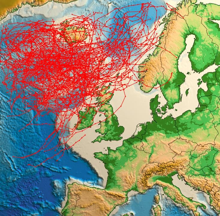
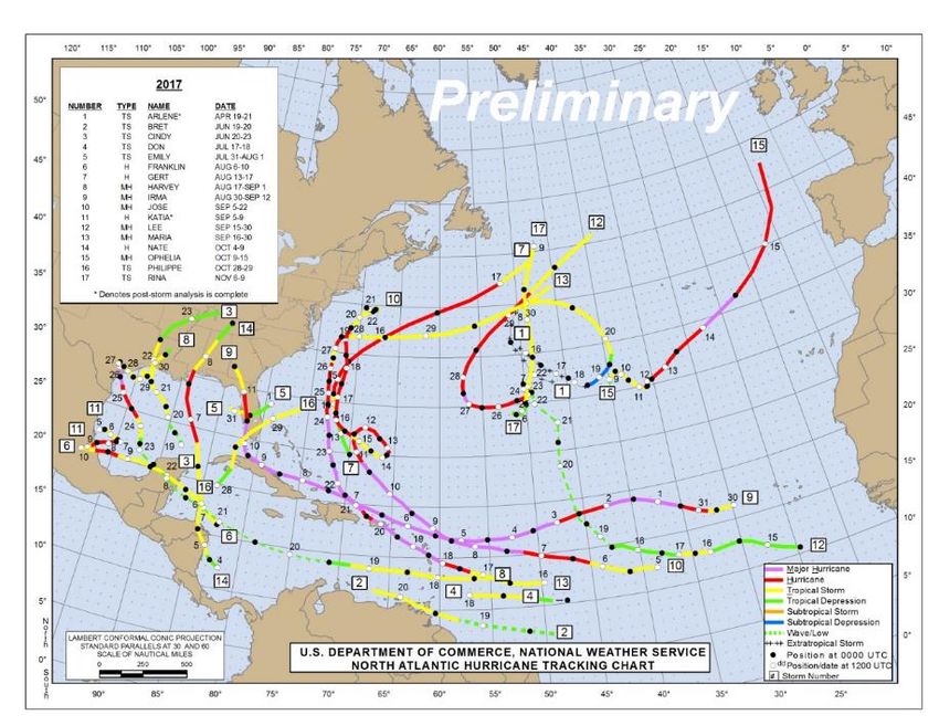
Forecast track of Ophelia:
                16th of October 2017

Deterministic Forecast                Ensemble Forecast
Storm Naming Reach, engagement and influence for warnings Authoritative Voice Single name Communication: ‘hashtag culture’ Collaboration with adjoining NMS’s Useful post-event for reference
Year 1: 2015-16
Task Team:
         European Cooperation
           on Storm Naming

          N: Norway/Sweden/Denmark

           W: Ireland/UK/Netherlands

      SW: France/Spain/Portugal/(Belgium?)

       SE: Cyprus/Greece/Israel …Tri-lateral
Italy/Croatia/Slovenia/Montenegro/North Macedonia

   Central: Germany/Austria/Switzerland……..
Making Ireland Weather
and Climate Prepared
MID-CENTURY (2041-2060) PROJECTIONS
EXTREME STORM TRACK
1976
to
2005
Mid-
century
RCP8.5
(No
lan, 33Meteoalarm
YELLOW: weather conditions that do not pose an immediate
threat to the general population, but only to those exposed to
risk by nature of their location and/or activity.

ORANGE: weather conditions which have the capacity to
impact significantly on people in the affected areas. All
recipients in the affected areas should prepare themselves in an
appropriate way for the anticipated conditions.

RED: recipients should take action to protect themselves
and/or their properties; this could be by moving their families
out of the danger zone temporarily; by staying indoors; or by
other specific actions aimed at mitigating the effects of the
weather conditions.
YELLOW: conditions that do not pose an immediate threat to
the general population, but only to those exposed to risk by
nature of their location and/or activity.

ORANGE: weather conditions which have the capacity to
impact significantly on people in the affected areas. All
recipients in the affected areas should prepare themselves in an
appropriate way for the anticipated conditions.

RED: recipients should take action to protect themselves
and/or their properties; this could be by moving their families
out of the danger zone temporarily; by staying indoors; or by
other specific actions aimed at mitigating the effects of the
weather conditions.
WIND (Gusts km/h):    >130    110    90
STATUS YELLOW :
Weather Alert –         RAIN (mm):            >70     60     30
Be Aware
                        SNOW / ICE:           > 8cm    3     30/20   >30   >27
Be Prepared
                        LOW TEMPS (C):
STATUS YELLOW :
Weather Alert –
Snow Warning
Be Aware Accumulations below 250m AMSL:
STATUS ORANGE: YELLOW: 3cm or greater in 24 hrs.
Weather Warning –
Be Prepared ORANGE: 3cm or greater in 6 hrs / 6cm or
greater in 12 hrs / 10cm or greater in 24 hrs.
STATUS RED: RED: 8cm or greater in 6 hrs / 12cm or greater
Severe Weather in 12 hrs / 20cm or greater in 24 hrs.
Warning - Take ActionSTATUS YELLOW : Low Temperature Warning
Weather Alert –
YELLOW: Minima of minus 3C or minus 4C
Be Aware expected over a wide area. Maxima of plus 1C
or plus 2C expected.
STATUS ORANGE:
Weather Warning – ORANGE: Minima of minus 5C to minus10C
Be Prepared (or lower) expected over a wide area. Maxima
of 0C or minus 1C expected.
STATUS RED: RED: Circa minus10C or lower for three or
Severe Weather more consecutive nights.
Warning - Take ActionSTATUS YELLOW : High Temperature Warning
Weather Alert –
YELLOW: Maxima in excess of 27C expected
Be Aware
and minima in excess of 16C over a wide area
for at least 36 hours (>27/16/>27).
STATUS ORANGE:
Weather Warning – ORANGE: Maxima in excess of 30C and
Be Prepared minima in excess of 18C expected over a wide
area for at least a 48hr period (>30/18/>30/18).
STATUS RED:
RED: As Orange criterion, but persisting for
Severe Weather several more consecutive nights.
Warning - Take ActionMet Éireann’s goal is to enhance support for impact-based decision making. 1)Is there anything we can do for you? 2)Conference calls with the Duty Forecaster are possible. 3)Our forecasts can be tailored for ‘Transport’s specific needs.
Met Éireann’s goal is to enhance support for impact-based decision making.

1) Are there any bespoke products we can provide for you?
Met Éireann’s goal is to enhance support for impact-based decision making.

1) Are there any bespoke products we can provide for you?

2) Our forecasts can be tailored for your specific needs…..
• Are the roads going to be icy?
• Will there be aquaplaning/hail?
• Will fog delay flights? Pile-ups on motorways?
• Will gales/rough seas cancel ferry crossings? Coastal damage?
• Will high temperatures ‘buckle’ train tracks? Snow/Leaves on tracks?
• Heat stress on flora/fauna/drought?
Met Éireann’s goal is to enhance support for impact-based decision making.

1) Are there any bespoke products we can provide for you?

2) Our forecasts can be tailored for your specific needs…..
• Are the roads going to be icy?
• Will there be aquaplaning/hail?
• Will fog delay flights? Pile-ups on motorways?
• Will gales/rough seas cancel ferry crossings? Coastal damage?
• Heavy rain/thunderstorms/flooding?
Making Ireland Weather
                           and Climate Prepared

IRELAND WINTER RAINFALL

                                                   48
Making Ireland Weather
and Climate Prepared
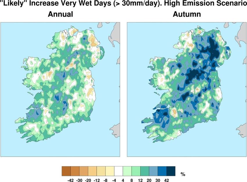
MID-CENTURY (2041-2060) PROJECTIONS
HEAVY RAINFALL EVENTS
Changes in rainfall patterns
will lead to an intensification
of the hydrological cycle
with increased instances of
high and low flow periods,
floods and droughts
(Murphy, Harrigan, Hall &
Wilby, 2013)
(Nolan, 2015)
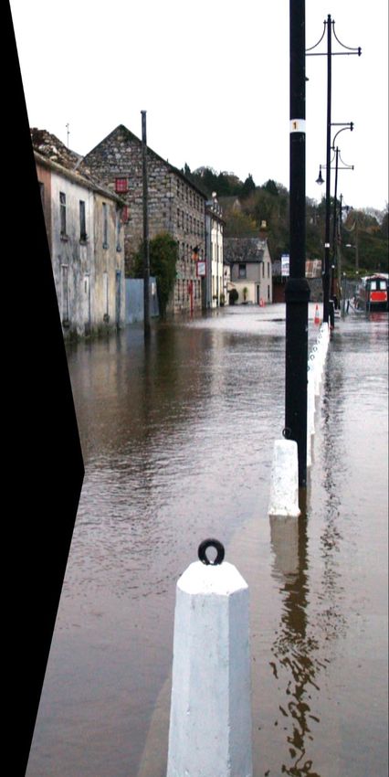
49Making Ireland Weather and Climate Prepared NATIONAL FLOOD FORECASTING AND WARNING SERVICE
Making Ireland Weather
                                               and Climate Prepared

         CHALLENGES FOR COMMUNITIES
         IN IRELAND

We must prepare for a changed climate.

▪   Extreme weather events will become
    more frequent and severe

▪   Infrastructure in coastal and low lying
    areas will become more vulnerable to
    erosion and storms.

▪   Increase occurrence and intensity of
    extreme precipitation events will
    bring increased risk of flooding.

▪   Changes in temperature will provide
    opportunities but also some risks.

                                                                       51
• NMS’s, as recognized in the Convention of the World Meteorological Organization (1947), are a fundamental part of national infrastructure and play an important role in supporting vital functions of governments. • The NMS (National Met Service) is clearly designated as the ‘official’ weather, climate and flood warning service and as the ‘National Authority’ in warning situations, to avoid public confusion. • Met Éireann is the NMS for Ireland and issues warnings for the 26 counties.
• NMS’s, as recognized in the Convention of the World Meteorological Organization
  (1947), are a fundamental part of national infrastructure and play an important role in
  supporting vital functions of governments.

• The NMS (National Met Service) is clearly designated as the ‘official’ weather, climate
  and flood warning service and as the ‘National Authority’ in warning situations, to
  avoid public confusion.

• Met Éireann is the NMS for Ireland and issues warnings for the 26 counties.
• The Met Office is the NMS for the UK and as such issues weather warnings for Northern Ireland, Scotland, Wales and England.
• NMS’s, as recognized in the Convention of the World Meteorological Organization
  (1947), are a fundamental part of national infrastructure and play an important role in
  supporting vital functions of governments.

• The NMS (National Met Service) is clearly designated as the ‘official’ weather, climate
  and flood warning service and as the ‘National Authority’ in warning situations, to
  avoid public confusion.

• Met Éireann is the NMS for Ireland and issues warnings for the 26 counties.

• The Met Office is the NMS for the UK and as such issues weather warnings for
  Northern Ireland, Scotland, Wales and England.
• The European MeteoAlarm system co-ordinates NMSs’ warnings across Europe. This Europe-wide system uses a common Red/Orange/Yellow colour-code. • Met Éireann is in the testing stage of a new warning display which will include all Irish Coastal Waters out to 30 Nautical Miles including around Northern Ireland as well as the Irish Sea. • As part of this development we are planning on using the MeteoAlarm system to deliver the UKMO warnings for Northern Ireland on the Ireland map on www.met.ie • This revised warning display is expected to be operational by summer 2019.
Greenhouse Effect
Greenhouse Effect
Making Ireland Weather
                                 and Climate Prepared

Could the warming be natural?

                                                         59
Making Ireland Weather
and Climate Prepared
SUMMARY OF GLOBAL CLIMATE
TRENDS AND PROJECTIONS
Temperatures have
increased by 1°C
from pre-industrial Increased CO2 levels are
levels and are desertification / continuing to rise.
projected to shifting rainfall Now above
increase by a patterns. 400ppm.
further 1.5-4.5°C
by 2100.
Sea level rising at
~3 mm/year,
Increasing glacial
projected rise of 0.5
retreat, decreasing
to 1 m by 2100
Arctic sea ice.
depending on
scenario.
60Expansion of Coastal Warning scheme to allow for Red wind warning in coastal regions only (i.e. up to 10km inland). In line with our co-operating NMS’s in France, Spain, Portugal and UKMO, Storms are only being named when the Orange wind criteria are forecast over a wide area (counties) and not coastal regions (defined as approximately 10km inland). Localized gusts > 130km/h can be forecast/observed without a Red warning but must be included in the Orange warnings.
Expansion of Coastal Warning
scheme to allow for Red wind
warning in coastal regions only (i.e.
up to 10km inland).

In line with our co-operating NMS’s
in France, Spain, Portugal and
UKMO, Storms are only being
named when the Orange wind
criteria are forecast over a wide area
(counties) and not coastal regions
(defined as approximately 10km
inland). Localized gusts > 130km/h
can be forecast/observed without a
Red warning but must be included
in the Orange warnings.
You can also read