Tropical Systems August-September 2021 - Northeast ...
←
→
Page content transcription
If your browser does not render page correctly, please read the page content below

Tropical Systems
August–September 2021
Fred
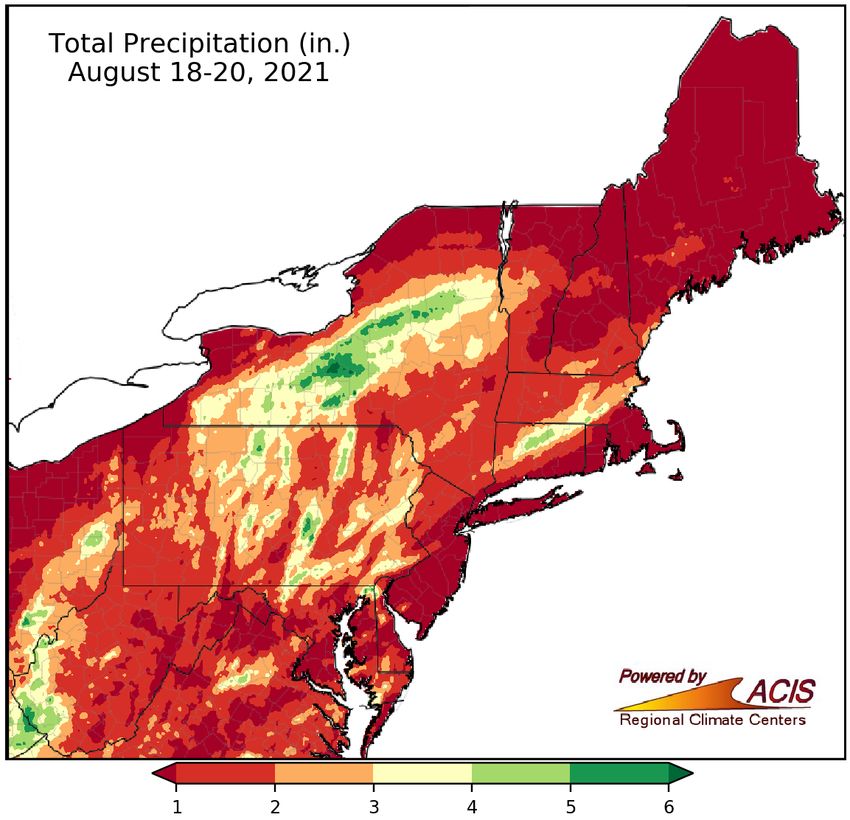
The remnants of Tropical Storm Fred moved through the Northeast from August 18 to 20.
• The storm spawned 10 weak (EF-0 or EF-1) tornadoes in the region, seven of which touched
down in Pennsylvania. Tornado damage included snapped and uprooted trees, some of which
fell on homes and cars, as well as siding and roof damage and flattened corn and wheat fields.
• Fred’s remnants, as well as a frontal system, produced heavy rain in several locations,
including parts of central/western New York, northern Connecticut, and central Pennsylvania
which saw between 4 and 8 inches of rain.
• Flash flooding led to impassable roads,
flooded basements, stranded vehicles, and
water rescues. In addition, a rare Flash
Flood Emergency was declared for part of
Steuben County, NY, where as many as 100
people were evacuated.
Fred's track. Credit: NWS Binghamton
A field flattened by a tornado
in Dauphin County, PA. Credit:
NWS State College
Rainfall totals from Fred and a frontal system.
Henri
Henri formed in the Atlantic on August 15 and strengthened into a hurricane off the
Mid-Atlantic Coast on August 21. Henri weakened into a tropical storm prior to making
landfall near Westerly, RI, on August 22. It was the first tropical storm or hurricane to
make landfall in the state since Hurricane Bob in August 1991.
• Henri dropped excessive rainfall amounts of 5 to 9 inches in portions of southeastern
New York, New Jersey, and eastern Pennsylvania. In fact, Central Park saw 1.94
inches in an hour and recorded its wettest two-day period on record for August,
picking up 7.12 inches of rain from August 21 to 22.
• Multiple locations from eastern Pennsylvania through New Jersey and southeastern
New York and into southern New England experienced flash flooding, with storm
reports noting flooded basements, closed roads, stranded vehicles, and water rescues.
Above: Henri's track. Credit: NWS Significant flash flooding occurred in Middlesex and Mercer counties and Newark in
Binghamton; Below: Rainfall totals from Henri. New Jersey, with at least 150 residents rescued or evacuated.
• Henri’s highest wind gusts reached 70 mph, bringing
down trees and power lines and resulting in numerous
power outages,
particularly in southern
New England.
• Henri’s remnants
spawned three short-
lived EF-0 tornadoes
in Massachusetts, with
damage consisting of a
few downed trees and
branches.
Contact: Northeast Regional Climate Center (nrcc@cornell.edu)
Ida
Rainfall
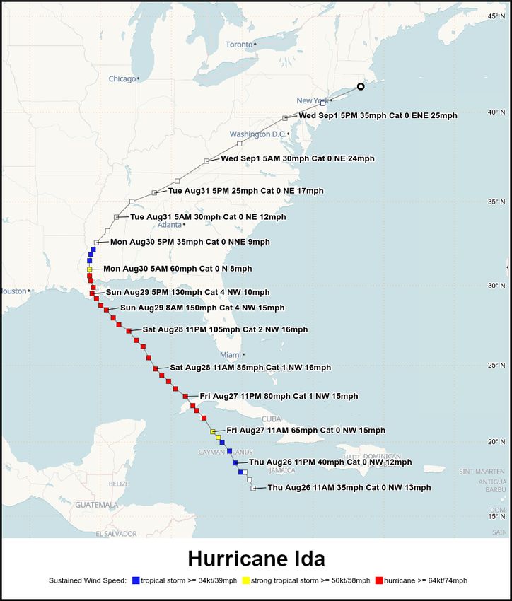
Ida formed on August 26 and rapidly intensified into a Category 4 hurricane as it passed
over extremely warm waters in the Gulf of Mexico. The major hurricane made landfall
in Louisianna on August 29. The storm weakened as it moved inland and was a tropical
depression as it trekked across the Northeast on September 1. The storm interacted with
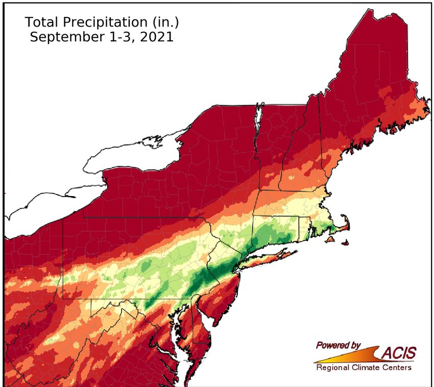
a stationary front, dropping catastrophic amounts of rain on parts of the region.
• A swath of the Northeast stretching from eastern Pennsylvania and northern/central
New Jersey through the New York City metro area and into southern New England saw
rainfall totals of more than 6 inches. In fact, a corridor of 8- to 11-inch rainfall totals
was found in southeastern Pennsylvania, northern/central New Jersey, and the New
York City area.
• Newark, NJ, saw 8.41 inches of rain, making it the site’s all-time wettest day on record
and on the first day of the month already making September 2021 the site’s fourth
wettest September on record. LaGuardia Airport, NY, also recorded its all-time wettest
day with 6.80 inches of rain. Meanwhile, Bridgeport, CT, which saw 5.77 inches of rain,
experienced its wettest September day. Rain fell at a rate of 3 to 5 inches per hour in
Ida's track. Credit: NWS Binghamton
some locations, with the bulk of the daily rainfall accumulating within a six-hour period
in most areas.
Rainfall totals from Ida.
Daily rainfall and rankings for select sites
in the Northeast.
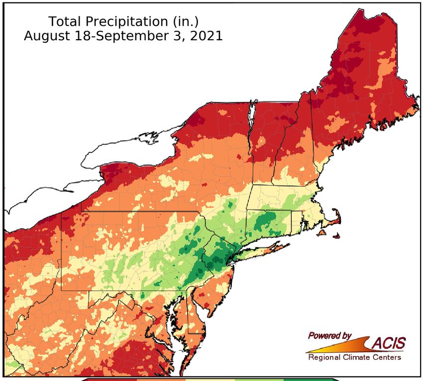
Rainfall from Fred, Henri, and Ida
• Rainfall totals from all three storms, Fred, Henri, and Ida, approached 18 inches. For sites such as Central Park, NY, and
Harrison, NJ, more than 3 months of rain fell during the 18-day period from August 18 to September 3. In fact, Central Park
recorded its all-time wettest two-week period of 16.19 inches of rain from August 19 to September 1, with records back to 1869.
The five wettest two-week periods on record at
Central Park, NY.
Combined rainfall totals from
Fred, Henri, and Ida.
Contact: Northeast Regional Climate Center (nrcc@cornell.edu)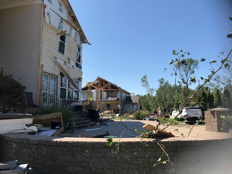
Ida
Rainfall and Climate Change
• An increase in the frequency of extreme rainfall is an expected consequence of global climate change. Warming
   temperatures enhance the evaporation of water from the oceans and also increase the capacity for the atmosphere to hold water
   vapor. When weather systems like hurricanes and fronts convert this vapor to liquid, more water is available to produce rainfall.
   The Northeast, in particular, has seen an increase in heavy rainfall. Rainfall extremes can be characterized by a specific amount of
   rainfall, for example 2 inches in a day, or in terms of the largest amount that can be expected to occur on average over some span
   of years, called a return period. An example of this is the 100-year-storm. Such an event is expected to occur on average once
   in 100 years or more specifically has a 1% chance of occurring in any given year. These rainfall amounts are also characterized
   by their duration, for instance the 100-year-storm based on the rainfall that occurs over an hour is different from that which occurs
   over a day. The rainfall that occurred with Ida exceeded the rainfall amounts that would be considered the 100-yr storm at many
   locations in Pennsylvania, New Jersey, New York, and Connecticut.
• Hourly rainfall totals were extreme. At Central Park, NY, the 3.15 inches of rain that fell between 9 and 10 pm on September 1 was
  the greatest hourly amount recorded in the 132-year history of the weather station. The 2-hour and 6-hour rainfall amounts of
  4.65 inches and 6.63 inches, respectively, were also record setting. The site had also seen an impressive 1.94 inches in an hour
  just a week earlier from Henri.
• Newark also received record rainfall over 1-, 2-, and 6-hour durations.The site's all-time wettest hour on record occurred between
  8 and 9 pm on September 1, with 3.24 inches of rain. The site’s record-setting two-hour rainfall total was 5.06 inches, while the
  record-setting six-hour total was 7.88 inches.
• The amount of rain that fell during 1-, 2-, and 6-hour periods was indeed rare. Both Central Park and Newark saw amounts that
  exceeded the 500-year storm. There is only a 0.2% chance, about the chance of being dealt 4-of-a-kind in a 5-card poker hand,
  that Newark would see 5.06 inches of rainfall in a 2-hour period during a given year.

                                                                                      Rainfall amounts in association with the remnants of
                                                                                      Hurricane Ida. Asterisks denote that the amount was the
                                                                                      greatest recorded in the indicated period of record.

                                                                Estimated return period of the rainfall associated
                                                                with the remnants of Hurricane Ida.

                                                                         • The bar chart to the left shows the rainfall associated with
                                                                           the 100-year storm at Newark based on different data
                                                                           records. If only data through the year 2000 is considered, the
                                                                           100-year daily rainfall event is estimated to be 7.85 inches.
                                                                           However, large rainfall events that occurred in 2005, 2006,
                                                                           and 2007 increased the 100-year storm to 8.08 inches when
                                                                           data through 2010 was considered. Two more daily rainfall
                                                                           extremes occurred from 2010–2020, 6.40 inches in 2011 and
                                                                           5.24 inches in 2014. These increased the 100-year storm to
                                                                           8.43 inches when the 1950–2020 data record is considered.
                                                                           Thus, the 8.41 inches that fell in Newark on September 1
                                                                           was very close to that associated with the 100-year storm.
• Climate models provide information on how extreme rainfall is expected to change in the future. Based on model-simulated rainfall,
  the 100-year storm at Newark is expected to continue to increase, reaching 8.64 inches during the 2020–2069 future period
  and growing to 9.50 inches in the 2050–2099 period. By the end of this century, rainfall totals like those associated with Ida can be
  expected to occur once about every 50 years as opposed to every 100 years at Newark.

Contact: Northeast Regional Climate Center (nrcc@cornell.edu)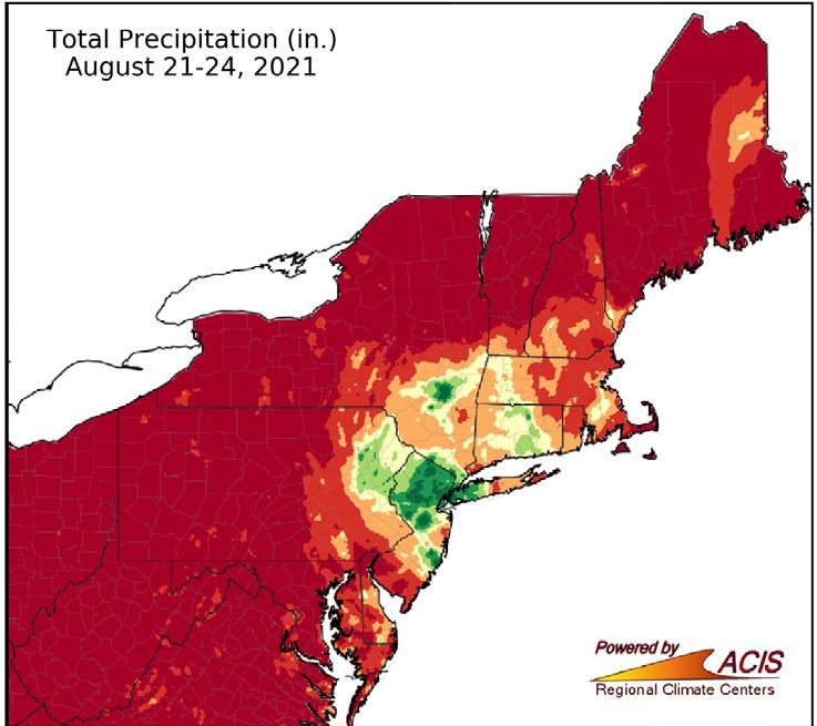
Ida
                                                   Water Levels
                                                 Many locations had just seen excessive rainfall from tropical systems Fred and Henri
                                                 within the past two weeks.
                                                 • With saturated soils, waterways already running high, and the deluge from Ida,
                                                   dozens of streamgages reached major flood stage, a water level high enough
                                                   for the possibility of “extensive inundation of structures and roads” and “significant
                                                   evacuations."
                                                 • Water levels reached historic levels at several long-term sites. For example,
                                                   Brandywine Creek at Chadds Ford, PA, which has records to the early 1900s,
                                                   reached 21.04 feet, approaching the operational limit of the gage and beating
                                                   the previous record of 17.15 feet from September 17, 1999. Similarly, the Raritan
                                                   River at Manville, NJ, which also has records back to the early 1900s, reached a
Record flooding along Brandywine Creek at Chadds
Ford, PA. Credit: NOAA
                                                   new   record high water level of 27.66 feet.
                                                 • Several other long-term sites reached near-record water levels. The Schuylkill
                                                   River at Philadelphia, PA, reached 16.35 feet, its second highest crest on record
                                                   and just below the all-time highest water level of 17.0 feet set on October 4, 1869.
Flash Flooding
Devastating flooding occurred in multiple locations.
• A rare Flash Flood Emergency, issued only
  when a significant threat to human life and
  property is happening or imminent, was declared
  in parts of southeastern Pennsylvania, northern/
  central New Jersey, and New York City. In fact, the
  New York National Weather Service office issued
  a Flash Flood Emergency for the first time ever, Neshaminy Creek at Langhorne, PA. Credit: Middle Atlantic River Forecast Center
  in northern New Jersey, then declared another for New York City, the first time the city has been under such a warning.
• Hundreds of roads were impassable, including portions of major highways such as the Vine Street Expressway through
  downtown Philadelphia and FDR Drive, a major thoroughfare along the east side of New York City. Countless vehicles were
  stranded and several people were swept away in rising waters across the region, including at least three instances of school
  buses getting stuck. Public transportation around the New York City metro area ground to a halt, stranding thousands. Floodwaters
  poured into New York City’s subway system, with more than 800 passengers rescued, buses and above-ground trains were
  stranded, and lower levels of Newark International Airport took on water.
• Some residents were advised to shelter in place. However, in a few areas, there were concerns that dams would be overtopped,
  resulting in thousands of people being evacuated. Numerous structures, including homes and apartments, were inundated by
  floodwaters. Between flooded roads and buildings, hundreds of water rescues were performed, with the Philadelphia National
  Weather Service office noting that “crews are running out of resources to rescue people stuck in flood waters.”
• There were at least 50 deaths due to Ida in the Northeast, including at least 13 in New York City and at least 30 in New Jersey,
  making it one of the state's deadliest weather events.
• Early estimates indicated the storm caused $117 million in damage in Pennsylvania and more than $50 million in damage in
  New York.
                                                   Tornadoes
                                                   Ida also produced at least 11 tornadoes, with the most in Pennsylvania.
                                                   • The strongest tornado, a rare EF-3 with winds of up to 150 mph, carved a 12.6-
                                                     mile path of destruction through southern New Jersey. The tornado tossed vehicles
                                                     and caused significant strutural damage to dozens of homes, leaving some
                                                     inhabitable. It also destroyed barns and toppled silos at the state's largest dairy
                                                     farm.
                                                   • Three EF-2 tornadoes, two in southeastern Pennsylvania and one in Annapolis,
                                                     MD, damaged buildings and homes, tearing off roofs, blowing out exterior walls,
                                                     and ripping off siding. They also caused considerable tree damage, with one
                                                     fatality when a tree fell on a house. All three tornadoes were on the ground for
Damage from an EF-3 tornado in Mullica Hill, NJ.     more than 6 miles.
Credit: NWS Philadelphia                           • In addition, straight-line winds of up to 80 mph caused damage in southeastern
                                                     Massachusetts.
Contact: Northeast Regional Climate Center (nrcc@cornell.edu)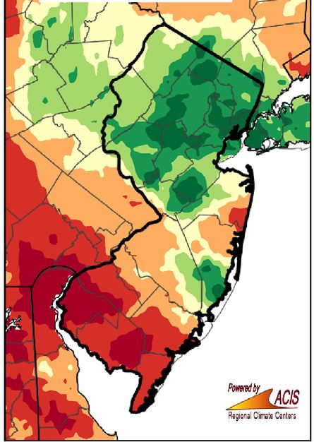

You can also read