NOAA NATIONAL HURRICANE CENTER - www.hurricanes.gov
←
→
Page content transcription
If your browser does not render page correctly, please read the page content below
NOAA NATIONAL HURRICANE CENTER

                               www.hurricanes.gov
                                 Facebook
                                 Twitter

Update on National Hurricane Center Products and Services for 2021
Changes include:

1) Issuance of Routine Atlantic Tropical Weather Outlooks on May 15

Although the Atlantic Hurricane season officially begins on June 1st, it is not uncommon
for tropical cyclones to form on or prior to that date. To provide more consistent
information on the potential for late May and early June systems, NHC will now begin the
routine issuance of the Atlantic Tropical Weather Outlook at 8 a.m. EDT on May 15, which
is when routine Tropical Weather Outlooks begin for the eastern Pacific basin. The
Tropical Weather Outlook is issued every six hours from May 15 through November 30
at 2 a.m., 8 a.m., 2 p.m., and 8 p.m. EDT. With the change to standard time on November
7, the issuance times are 1 a.m., 7 a.m., 1 p.m., and 7 p.m. EST. The Tropical Weather
Outlook describes significant areas of disturbed weather and their potential for tropical
cyclone formation during the next five days. An accompanying graphic that highlights
each disturbance and its potential formation area is available on the NHC website at
www.hurricanes.gov.

Special Tropical Weather Outlooks are issued to provide updates, as necessary, in
between the regularly scheduled issuance of the Tropical Weather Outlook or when
needed outside of the May 15 to November 30 issuance period. Special Tropical Weather
Outlooks are issued under the same WMO and AWIPS headers as the regular Tropical
Weather Outlooks.

2) Greek Alphabet replaced with alternate name list for tropical storms

On March 17, 2021, the World Meteorological Organization Hurricane Committee
members agreed to create a supplemental list of names A-Z (excluding Q, U, X, Y, Z on
the Atlantic list) that would be used in lieu of the Greek alphabet when the standard
tropical storm name list is exhausted in a given season in either the Atlantic basin or
eastern North Pacific basin. Names on this list could be retired and replaced, when
required. The supplemental list is at www.nhc.noaa.gov/aboutnames_history.shtml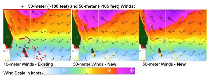
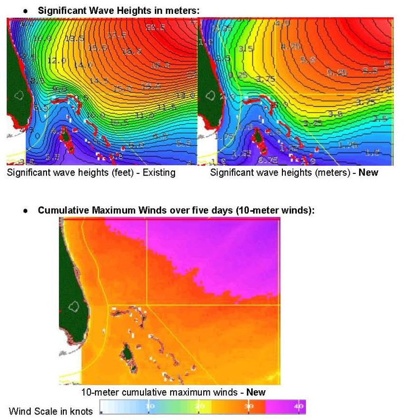
3) Graphical depiction of storm surge inundation values

NHC will continue to provide an experimental graphic in 2021 that will depict the expected
storm surge inundation values for the United States Gulf and Atlantic coasts, Puerto Rico,
and the U.S. Virgin Islands that are provided in the tropical cyclone public advisory
(TCP). These values represent the peak height the water could reach above normally
dry ground somewhere within the specified areas. This graphic will be made available on
the NHC webpage.

4) Upgrade of the operational probabilistic storm surge (P-Surge) forecasting
system
For the 2021 hurricane season, NHC and the Meteorological Development Lab (MDL) will
upgrade the operational probabilistic storm surge (P-Surge) forecasting system from
version 2.8 to 2.9. P-Surge is the primary modeling system and guidance information
which informs all NWS coastal inundation forecasts, warnings, and risk communication
during tropical cyclone landfall threats.
The upgrade includes improved tropical cyclone wind structure and storm size information
that will give better predictability & accuracy, run-to-run consistency, and statistical
reliability. Storm size and structure (or how far the winds extend from the center) are often
some of the most important factors in storm surge flooding.
The improvements stand out best between 36-60 hours prior to landfall, giving better
 overall predictability in the critical 48-60-hour lead window essential for an effective
 evacuation decision making and execution. Because of the improvement, NHC will extend
 the lead times of the availability of P-Surge guidance and the associated potential storm
 surge flooding graphic from 48 hours to 60 hours in situations where there is high
 confidence. However, the existing timing of storm surge watches (48 hours) and
 warnings (36 hours) will remain unchanged as will the existing P-Surge data formats,
 dissemination systems, file naming conventions, and WMO headers.

 In addition, NHC will update the potential storm surge flood graphic to more effectively
 mask intertidal areas and wetlands, including marshes and bayous. This will allow users
 to better focus on where flooding could occur over normally dry land or within populated
 areas.

 This P-Surge upgrade will provide accurate guidance to key partners for more precise
 placement of key instruments and sensors in advance of impending landfalling tropical
 cyclones in support of planned COASTAL Act implementation at NOAA.

5) New experimental weather forecast elements added for “Blue Water” Mariners

To improve services for the “Blue Water” mariner well away from land, the Tropical Analysis
 and Forecast Branch (TAFB) of NHC is introducing new experimental weather forecast
 elements via our Marine Graphical Composite Forecast map. While this is internet-based
 and not necessarily available to everyone offshore, it is designed to help any mariners in
 port who may have limited access to the internet, such as relatively low-bandwidth WiFi
 provided in many remote marinas and ports. The new weather elements have been added
 to the existing set to help keep mariners informed and safe. The new experimental weather
 forecast elements include the following:
These new experimental weather elements are available via the existing TAFB’s Marine
Graphical Composite Forecast maps:

Gulf of Mexico, Caribbean Sea and Tropical North Atlantic
https://www.nhc.noaa.gov/marine/forecast/enhanced_atlcfull.php
Tropical Eastern North Pacific:
https://www.nhc.noaa.gov/marine/forecast/enhanced_epacfull.php
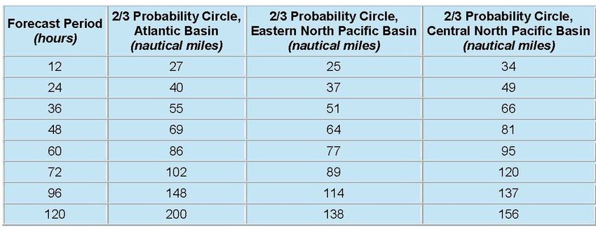
6) Annual update to the track forecast error cone

The size of the tropical cyclone track forecast error cone for the Atlantic and eastern North
Pacific basins will be very similar compared to 2020, with any changes less than 5 nautical
miles at all time periods. The cone represents the probable track of the center of a tropical
cyclone, and is formed by enclosing the area swept out by a set of imaginary circles placed
along the forecast track (at 12, 24, 36 hours, etc.). The size of each circle is set so that
two-thirds of historical official forecast errors over the previous five years (2016-2020) fall
within the circle. The circle radii defining the cones in 2021 for the Atlantic, and eastern
and central North Pacific basins are given in the table below:

 A video showing how to properly interpret and use the cone graphic can be found at:
 www.nhc.noaa.gov/cone_usage.php

 Pronunciation of storm names

 Pronunciation guides for storm names including the phonetic pronunciations of all Atlantic
 and eastern North Pacific storm names is found on the NHC website at:

 Atlantic: www.nhc.noaa.gov/pdf/aboutnames_pronounce_atlc.pdf
 Eastern North Pacific: www.nhc.noaa.gov/pdf/aboutnames_pronounce_epac.pdf

 Social Media

 1) The National Hurricane Center has a Facebook page. The “NOAA NWS National
 Hurricane Center” page provides updates about the NHC outreach and education
 campaign and other items that might be of interest to the public throughout the year.
 During the hurricane season, the site contains a daily tropical weather update for both the
 Atlantic and eastern North Pacific basins, as well as alerts regarding any tropical cyclone
 activity as needed. The NHC also conducts Facebook Live briefings during tropical
 cyclone events. The NHC Facebook page is found at: www.facebook.com/NWSNHC
2) The National Hurricane Center is on Twitter – and has five twitter accounts:

Interactive Outreach (@NWSNHC) - The broadest in scope of NHC's Twitter accounts,
@NWSNHC is our primary mechanism for engaging the public and our partners in two-
way conversations. This account will cover general topics such as education and
outreach, NWS products and policies concerning tropical cyclones, significant events, or
just fun facts – from across all the branches that comprise NHC.

There are two operational Twitter feeds, one for the Atlantic basin - @NHC_Atlantic
(which includes the Gulf of Mexico and Caribbean Sea) and one for the eastern North
Pacific basin - @NHC_Pacific. Automated tweets are sent via these accounts whenever
NHC issues:

•     A public advisory regarding a tropical cyclone (TCP)
•     A tropical cyclone update (TCU)

Each tweet contains a link to access the corresponding product on the NHC website.
These two operational accounts will also be used to supplement and augment the formal
tropical cyclone product suite, with occasional notices on such topics as reconnaissance
aircraft status, announcements on NHC’s intention to initiate advisories on a new tropical
cyclone, highlights of key messages during active cyclones, etc.

The NHC storm surge group can be followed on Twitter at @NHC_Surge
This account enhances storm surge forecasts by providing real-time reports and
observations during an event (resources permitting). The feed will enhance preparedness
and outreach efforts throughout the year, and provide news and announcements on
updates to the SLOSH modeling system and storm surge decision support tools.

The Tropical Analysis and Forecast Branch (TAFB) is on Twitter at @NHC_TAFB
TAFB, an operational arm of the NHC, is responsible for issuing more than 100 marine
products daily covering millions of square miles of the Atlantic and eastern Pacific Ocean.
This account highlights significant weather events over the marine area as well as its
outreach programs.

3) An audio podcast will be available when the media pool is activated.

The audio podcast RSS/XML feed for top-of-the-hour briefings will be operational when
the media pool is activated: www.nhc.noaa.gov/audio. The media pool is typically
activated when a hurricane watch is issued for any portion of the U.S. contiguous
coastline.
9) On the Web:

National Hurricane Center: www.hurricanes.gov

Graphical Tropical Weather Outlook:
www.nhc.noaa.gov/aboutnhcgraphics.shtml#GTWO

Definition of NHC Track Forecast Cone: www.nhc.noaa.gov/aboutcone.shtml
                                       www.nhc.noaa.gov/cone_usage.php

National Hurricane Preparedness Week: www.hurricanes.gov/prepare

National Hurricane Center Facebook page: www.facebook.com/NWSNHC

National Hurricane Center Twitter page: www.nhc.noaa.gov/twitter.shtml

Contact: NHC Public Affairs: nhc.public.affairs@noaa.gov

April 01, 2021
You can also read