IOWA MONTHLY WEATHER SUMMARY - JUNE 2020
←
→
Page content transcription
If your browser does not render page correctly, please read the page content below
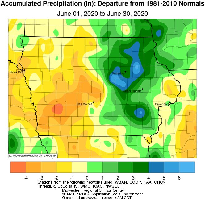
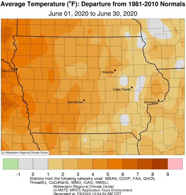
IOWA MONTHLY WEATHER SUMMARY – JUNE 2020
General Summary: Temperatures averaged 72.9 degrees or 3.2 degrees above normal while precipitation totaled
4.85 inches or 0.17 inch below normal. June 2020 ties 1954 and 2005 as the 18th warmest on record. The month also
tied 1957 as the 66th wettest/82nd driest June in 148 years of statewide records. A warmer and wetter June last
occurred in 2018 while a drier June occurred just last year.

Temperatures: Iowa experienced warmer than normal temperatures statewide during June. Positive departures
were reported across the state with locations in western Iowa observing up to five degrees above normal; isolated
pockets in eastern Iowa reported near-average conditions. June’s statewide average maximum temperature was
83.7 degrees, 3.1 degrees above normal while the average minimum temperature was 62.1 degrees, 3.3 degrees
above normal. Le Mars (Plymouth County), Sioux Center 2 SE (Sioux County) and Spencer Municipal Airport (Clay
County) reported the month’s high temperature of 100 degrees on the 2nd, on average 22 degrees above normal.
Sioux Center 2 SE also reported 100 degrees on the 7th. Fayette (Fayette County) reported the month’s low
temperature of 44 degrees on the 1st, eight degrees below normal.

A few notable dates in June include the 2nd as the warmest day of the month, with daytime highs in the mid to
upper 90s across a majority of Iowa. The hottest conditions were found in northwestern Iowa, where some stations
reported triple digit heat indices. Multiple stations broke their high temperatures for the date with the statewide
average high of 92 degrees, 15 degrees above normal. The 7th was windy, hot and sunny with highs reaching into
the mid to upper 90s across much of Iowa. Skies remained clear overnight into the 8th with morning lows ranging
from the upper 60s east to mid 70s west; the statewide average low was 69 degrees, 12 degrees above normal.

Cloudless conditions persisted overnight on the 14th and through the 15th as with gusty southerly winds across
northwestern Iowa. High temperatures were again warmer in western Iowa, generally in the upper 80s with some
90-degree readings; upper 70s and low 80s were observed in eastern Iowa. Morning lows on the 16th remained in
the upper 60s and low 70s across the western three-quarters of Iowa with positive departures of up to 15 degrees;
Rock Rapids (Lyon County) reported a low of 72 degrees. In stark contrast and on the opposite corner of Iowa,
Burlington Municipal Airport (Des Moines County) reported a low of 54 degrees, nine degrees below average.

Cooling Degree Days: Home air conditioning requirements, as estimated by cooling degree day totals, averaged 48%
more than last June and 39% more than normal. Cooling degree day totals since January are running 44% more than
last year at this time and 17% more than normal.

Precipitation: While the statewide average precipitation was near average, there couldn’t be a starker contrast
between eastern and western Iowa. Much of Iowa’s eastern half reported totals from 2.00 inches to 6.00 inches
above average. On the other hand, western Iowa reported precipitation deficits of up to 4.00”. Monthly
precipitation totals ranged from 0.46 inch at Atlantic Municipal Airport (Cass County) to 12.26 inches at Oelwein 1E
(Fayette County).

Clouds began to increase as a warm front lifted through the state into the morning of the 1st, bringing light to
moderate rain showers across portions of Iowa. Heavier rain fell in northern Iowa, especially from Worth through
Howard counties, where Elma reported 0.92 inches. Amounts quickly tapered off to a few tenths of inch in the two
immediate southwest counties. Showers and strong thunderstorms began to fire along a strong frontal boundary
along the Iowa-Minnesota border during the evening hours of the 2nd. A few isolated severe thunderstorms re-fired
in southwestern and central Iowa in the early morning hours of the 3rd. The system moved southeast through Iowa
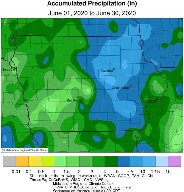
and cleared the state just before noon. Rain totals were highest in eastern Iowa where multiple stations reported
totals over an inch with lighter amounts farther west; Davenport Municipal Airport (Scott County) reported 1.91
inches.

June 4th was another active weather day as an initial line of thunderstorms popped up in the evening across eastern
Iowa. Many of the storms turned severe and produced multiple reports of hail and straight-line winds. Locally
heavy downpours were also observed. A second round of strong thunderstorms moved into north-central and
eastern Iowa overnight into the 5th. Some thunderstorms turned severe and produced over 40 reports of severe
straight-line winds as they sped through central Iowa. Wind gusts of up to 70 mph were observed in multiple
counties with widespread damage to trees. Measurable rain was reported across Iowa’s northeastern three-
quarters in the range of 0.25 inch to over 1.00 inch. Storm Lake (Buena Vista County) reported 1.82 inches with the
statewide average of 0.34 inch.

On the 8th, winds gradually shifted from the east across southeastern Iowa in advance of the remnants of Tropical
Storm Cristobal. Now a tropical depression, the system entered Iowa from northeastern Missouri in the early
morning hours of the 9th. Cristobal became only the second tropical system on record to move through Iowa with
the first occurrence happening on September 11th, 1900. While the depression was fast moving and cleared the
state just after 9:00 pm, very heavy rain was reported across eastern Iowa through the day. Behind Cristobal, a
strong low pressure system and attendant cold front pushed through western Iowa and brought additional rain to
much of the state. The mid-latitude system moved out of Iowa just after noon on the 10th. Two-day rain totals
showed over 200 NWS coop stations and CoCoRaHS rain gauges reporting at least an inch with all Iowa stations
observing measurable totals. Ten gauges across a narrow south-to-north swath in eastern Iowa observed over four
inches; Vinton (Benton County) reported 4.11 inches while Stanley (Buchannan County) observed 4.65 inches.
Storm totals in western Iowa were generally above 0.50 inch with the statewide average total at 1.53 inches. Windy
and cooler conditions built in behind the systems as cloud cover cleared into the afternoon hours.

Clouds began to increase across western Iowa on the 18th as a low pressure center pushed into the state.
Widespread rain was reported as showers and thunderstorms fired along a cold front during the afternoon hours.
Some storms were strong to severe with a brief spin-up tornado reported in Lakota (Kossuth County). Measurable
rain was reported over most of Iowa with more than 60 stations reporting over an inch. A rain gauge in Missouri
Valley (Harrison County) reported 3.62 inches with the statewide average of 0.52 inch. The system continued into
eastern Iowa on the 19th leaving behind rainfall in the state’s eastern quarter. The heaviest totals were found in
northeastern and southeastern Iowa. Lansing (Allamakee County) reported 3.46 inches while Keosauqua (Van
Buren County) observed 3.04 inches.

Thunderstorms began popping up across eastern Iowa during the afternoon on the 21st ahead of a strong
disturbance that produced some severe thunderstorms across northern Iowa over the evening hours. There were
several reports of one-inch hail and severe straight-line winds in excess of 60 mph; Sheldon (O’Brien County)
reported a 62 mph wind gust. Further development occurred in the early morning hours as the complex over
eastern Iowa consolidated, bringing locally heavy downpours and strong wind gusts. Additional storms, some
severe, formed in southern and central Iowa through the morning on the 22nd morning and moved east as another
round fired in west-central Iowa. The cold front finally cleared Iowa overnight into the 23rd with two-day rain totals
at 7:00 am showing the highest amounts in eastern Iowa, where flash flood warnings were in place. All Iowa
stations reported measurable rainfall with much of Iowa’s northeast quadrant observing totals above 1.50 inches.
Nearly 70 stations reported totals over 2.00 inches with a statewide average rainfall of 1.17 inches; Clutier (Tama
County) reported 5.17 inches.
Early on the 26th, waves of showers and thunderstorms propagated across the state ahead of a low pressure
center. Some severe storms moved through eastern Iowa through the evening hours, while overnight into the 27th
a sluggish boundary draped over southern Iowa re-fired slow moving storms. Higher rainfall was reported in the
southeast with totals generally between a few tenths of an inch to over two inches; Washington (Washington
County) observed 2.21 inches. Spotty thunderstorms popped up across east-central Iowa as an arc of
thunderstorms pushed into southwestern Iowa along with a trailing shield of showers. Totals reported at 7:00 am
on the 28th across Iowa’s southern half ranged from a few tenths of an inch in the southwest dropping off farther
east. Williamsburg (Iowa County) reported 0.93 inch after multiple storms passed over the station. Showers and
thunderstorms continued to push through Iowa during the afternoon with isolated thundershowers popping up
into the evening hours. Twenty-four hour totals showed widespread rainfall between 0.10 inch to 0.25 inch.
Heavier pockets of rain were reported in southeastern Iowa, where Keokuk Lock and Dam (Lee County) observed
0.81 inch. Cloud cover increased across eastern Iowa through the daytime hours; a small disturbance over
northeastern Missouri spun several lines of slow moving showers and thunderstorms over southeastern Iowa just
after midnight on the 30th. The system lingered for most of the day with totals ranging from 0.08 inch at Burlington
Municipal Airport (Des Moines County) to 1.26 inches at Fort Madison (Lee County).

Outlooks: July climatological outlooks indicate elevated chances of warmer than normal conditions across Iowa. In
terms of precipitation, there are Equal Chances (EC) of above, below or near-average conditions. Initial short-term
outlooks for the first two weeks of July show high probabilities of unseasonable warmth and chances of near-average
to drier conditions. The current July-August-September outlooks indicate elevated chances of warmer and wetter
conditions.

US Drought Monitor: With precipitation deficits accumulating across western Iowa, around 18% of the state was
classified as D0 or “Abnormally Dry” by the US Drought Monitor at the end of June. Moisture stress from abnormally
dry conditions manifests as rolled corn leaves and flipped soybean leaves. Lawns are also starting to go dormant.
With warm and dry conditions continuing across portions of Iowa, D0 conditions will expand as well as the possibility
of D1 or “Moderate Drought” conditions being introduced. Please send any impact reports that indicate agricultural
dryness to the US Drought Monitor or to the contact information below.

Justin Glisan, Ph.D.
State Climatologist of Iowa
Iowa Dept. of Agriculture & Land Stewardship
Wallace State Office Bldg.
Des Moines, IA 50319
Telephone: (515) 281-8981
E-mail: Justin.Glisan@IowaAgriculture.gov
IOWA PRELIMINARY MONTHLY WEATHER SUMMARY - JUNE 2020

                                                        June 2020
                                              WEATHER BY DISTRICTS
                TEMPERATURE (F)                   COOLING DEGREE DAYS                             PRECIPITATION (inches)

                     June 2020          June 2020      Since Jan., 1, 2020    June 2020      Since Jan.1, 2020
DISTRICT         Average Departure* Average Departure* Average Departure* Average Departure* Average Departure*

Northwest          73.4        +4.6         265        +104         294        +77         3.42       -1.31       11.99       -2.87
North Central      71.9        +3.6         226        +73          257        +52         5.15       -0.04       15.71       -1.18
Northeast          70.0        +1.5         178        +41          200        +21         8.45       +3.35       19.85       +2.58

West Central       74.7        +4.8         299        +118         332        +88         2.88       -2.03       11.36       -5.17
Central            72.8        +3.2         248        +71          282        +42         5.33       -0.03       16.18       -1.61
East Central       71.8        +1.6         219        +44          249        +11         5.60       +0.65       17.74       +0.29

Southwest          75.3        +4.3         316        +114         364        +86         2.35       -2.78       12.33       -5.56
South Central      73.6        +3.4         268        +75          315        +52         3.82       -1.12       15.88       -2.25
Southeast          73.0        +1.5         251        +47          298        +16         6.43       +1.61       19.22       +0.53

STATE             72.9       +3.2     241       +67                 274       +39        4.85       -0.17     15.52        -1.68
* Departures are computed from 1981-2010 normals.                      Monthly estimates are preliminary and are likely to change.
  The weather data in this report are based upon information collected by the U. S. Dept. of Commerce, NOAA National Weather Service.
You can also read