Multimodal Modeling and Design - Ford Site | St. Paul, MN November 2016 - City of Saint Paul
←
→
Page content transcription
If your browser does not render page correctly, please read the page content below
Ford Site | St. Paul, MN

Multimodal
Modeling and
Design

November 2016
Agenda

 ■ 6:30 p.m. Welcome

 ■ 6:35 p.m. Councilmember Tolbert

 ■ 6:40 p.m. Status of Ford Site Planning

 ■ 6:50 p.m. Study Overview and Results

 ■ 7:30 p.m. Questions and Answers

 ■ 7:45 p.m. Topic Boards - comments and questions

                                              NOVEMBER 2016   2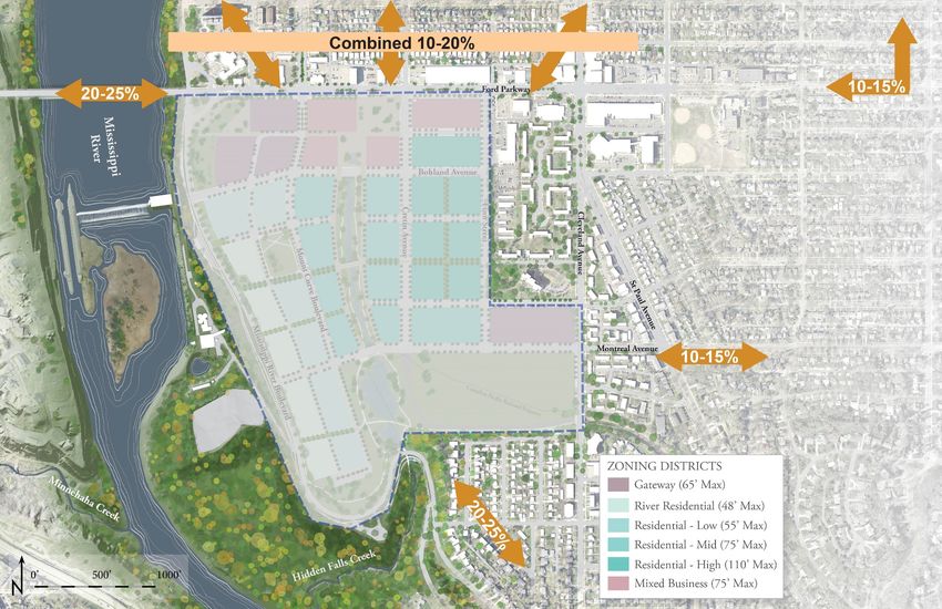
Project Timeline – Public Process

                                    NOVEMBER 2016   3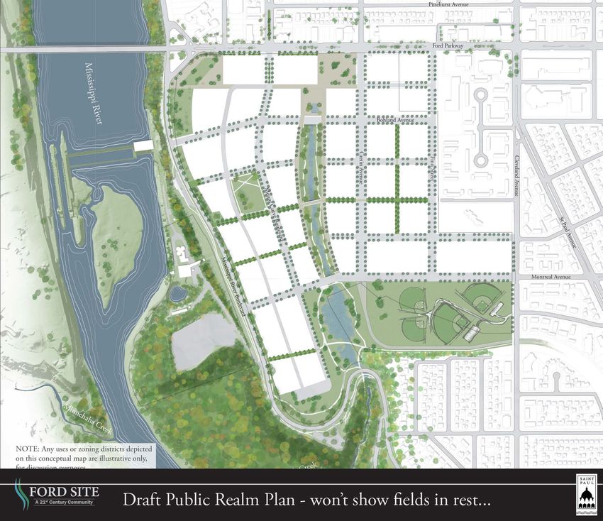
Councilmember Chris Tolbert

“Any business only exists to make peoples’ lives better. At a
certain point, shoving more vehicles into urban environments
doesn’t do that.”            - Bill Ford, September 2014

                                                       NOVEMBER 2016   4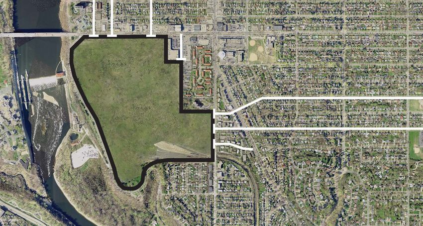
A 21st Century Community for Transportation
■ Connect the neighborhood to the Mississippi River
■ Expand live, work, and play opportunities for onsite,
  neighborhood, and regional users
■ Provide multiple connections to the surrounding
  transportation network
■ Ensure access for all people using all modes of transportation

                                                      NOVEMBER 2016   5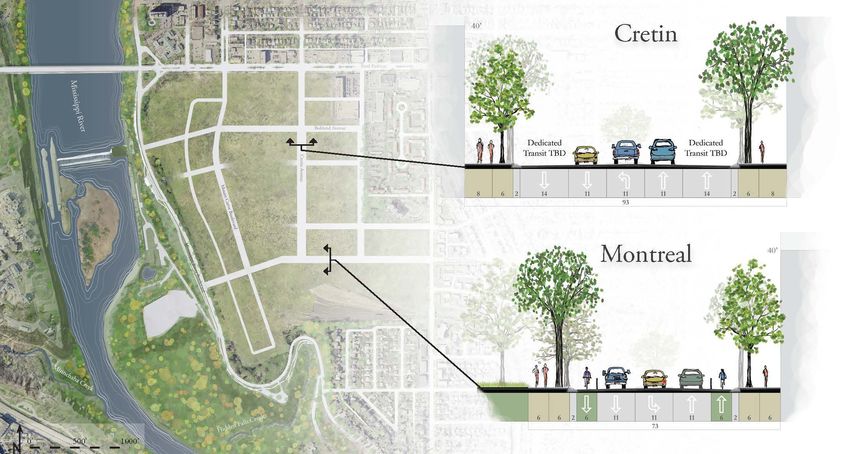
Traffic Impact Study

■ Future master developer       What
                                          Traffic Modeling         Traffic Impact
                                                Study                  Study
  will be required (under
                                When         2015/2016              2018/2019
  State law) to do a full
                                         To inform Ford site    To examine viability
  traffic impact study on the   Why       zoning and public         of proposed
  final proposed                             realm plan            development

  development plan                      High level analysis -    Detailed Analysis -
                                        based on POTENTIAL      based on PROPOSED
                                How        transportation          transportation
                                            network and             network and
                                            connections             connections

                                         Examines on-site,       Examines on-site,
                                Where   adjacent, and more      adjacent, and more
                                          distant impacts         distant impacts

                                             City pays            Developer pays
                                Who
                                             for study              for study

                                                                     NOVEMBER 2016     6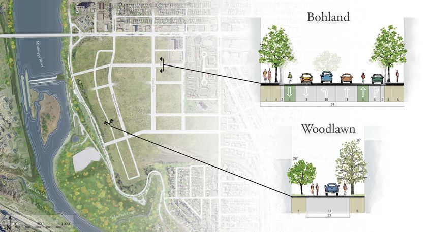
Existing Street Network

                          NOVEMBER 2016   7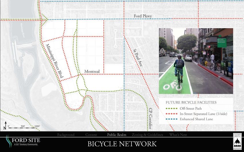
Ford Site as Barrier

                       NOVEMBER 2016   8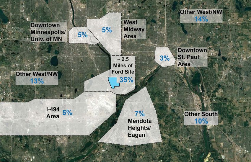
Concept Public Realm Plan

                            NOVEMBER 2016   9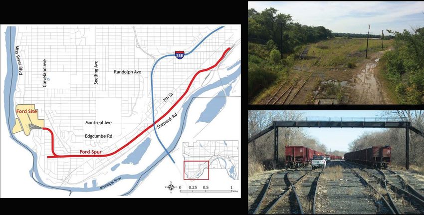
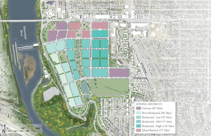
Concept Zoning Plan

                      NOVEMBER 2016   10
Ford Site Transportation Network
NOVEMBER 2016 11Primary Streets
NOVEMBER 2016 12Secondary Streets
NOVEMBER 2016 13Walking and Biking Network
NOVEMBER 2016 14Multimodal Modeling and Design
The purpose of this effort is to:
■ Develop an understanding of how travel will work to,
from, and within the Ford Site.
■ Review land use and transportation network designs
that maximize the value of, and minimize the negative
impacts of, Ford site development.
NOVEMBER 2016 5Transportation Trends and Principles
NOVEMBER 2016 16Transportation Trends and Principles
NOVEMBER 2016 17
39Transportation Trends and Principles
NOVEMBER 2016 18Transportation Trends and Principles
Social &
Recreational
Shopping &
Errands
School & At Work
Work Commute
SOURCE:
Metropolitan Council
Travel Behavior Inventory
NOVEMBER 2016 19Transportation Trends and Principles
In the United States*:
Public transportation use increased 37%
since 1995 and is at the highest rate since
1956
Bike commuting increased 60% since 2005
Walking increased 6% since 2005
■ Miles driven per person
in United States
decreased 9% since
2005
■ Increased density
reduces car trips
*Source: 11 Reasons Why Trains, Buses, Bikes and Walking Move Us Toward a Brighter Future, by Jay Walljasper
NOVEMBER 2016 20Finn St
Transportation Observations
Cleveland Ave
Cretin Ave
Highland Parkway
Reduce
Traffic
Ford Parkway
Montreal Ave
Principal Arterial
(Highway)
A Minor Arterial
Cleveland Ave
B Minor
Major Collector
Local RoadFinn St
Transportation Observations
Cleveland Ave
Cretin Ave
Highland Parkway
Access Reduce
management Traffic
on Ford
Ford Parkway
Access Access Intersection
? ? management
Evaluate capacity
Montreal Ave
Minimize vehicle
connectivity to Intersection
Miss. River Blvd. improvement
Access
?
Principal Arterial
(Highway)
A Minor Arterial
Cleveland Ave
B Minor
Major Collector
Local RoadTransportation Observations - Origins
NOVEMBER 2016 23Transit Network
NOVEMBER 2016 24Canadian Pacific Rail Spur
NOVEMBER 2016 25Public Input – Streets, Parking, Traffic
Public Priorities:
■ Accommodate cars, but don’t
encourage them
■ Design streets to calm traffic
and prevent speeding
■ Direct traffic to larger through
streets in area
■ Provide most parking in
structured ramps, with some on-
street and in alleys
NOVEMBER 2016
26Public Input – Bikes, Pedestrians & Transit
Public Priorities:
■ Design safe, designated space
for bicycles and pedestrians
■ Provide well-connected,
frequent transit and good
shelters
■ Balance needs of cars, bikes,
pedestrians, and transit in public
right-of-way
NOVEMBER 2016
27Performance Evaluation
Goals Targets Measures
• Pedestrian Access • Desired • Physical
• Minimized Vehicle • Acceptable • Operational
Travel • Unacceptable • Policy-oriented
• Parking Management • Use-based
NOVEMBER 2016 28Development Goals - Samples
1. The Ford site should provide multimodal access with
an express goal of minimizing vehicular impacts.
People traveling to/from the Ford site should have
choices of walking, biking, and taking transit.
2. Vehicular level of service on neighborhood streets
should continue to function within acceptable levels.
3. Parking should be shared and minimized as part of
overall site plan. The Site should accommodate cars,
but not encourage them.
NOVEMBER 2016 29Performance Targets
■ Desired
■ Acceptable
■ Unacceptable
NOVEMBER 2016 30Performance Measures
Physical Policy-Oriented Use-Based
• Street Design Elements • Transit Stop • Surveys
• Spatial Measurement Amenities • Peak Hour
• Internal Street Multimodal Traffic
• Parking Spaces per
1,000 SQFT Speeds • Mode Share
• Transit Stop Accessibility • Shared Parking • Peak Hour
• Roadways with Sidewalks Percentage Vehicular Traffic
• Sidewalk Width • EV Ownership • Trip Lengths
• Parking Price
• Bicycle Parking Distance
• Bicycle Lockers Operational
• Pedestrian Crossing • Bicycle Showers
Distance • Bus Frequency
NOVEMBER 2016 31Other Trip Generation Models
NOVEMBER 2016 32Multimodal thinking captures
the totality of how individuals
make transportation choices.
• A complementary mix of uses produces
shorter, more efficient trips.
• People, especially young people, are
driving less than ever.
• Connected street networks distribute
vehicular trips.
• Shared parking facilities minimize
overall parking need.
• A diversity of transportation options
minimizes car ownership.
• People are more willing to walk and
walk farther in safe, interesting
environments.
• Public transportation should be frequent,
reliable and, convenient.
• Bicycle facilities designed for casual
users attract greater use.
41Land Use Quantity
Civic 150,000 GFA
Employment (Office, etc.) 450,000 GFA
Retail 300,000 GFA
Residential 4,000 Units
Model Steps Trips Generated*
ITE vehicle trips 38,600
Person trips (1.08 AVO applied) 41,700
*Trips Generated figures are rounded to the nearest 100 trips
4243
X

    43
Internal
Capture
X
Complementary uses:
Have demand at different times of day to allow for shared parking
Support quality of life, such as food outlets near offices or grocery
stores near housing
Can absorb trips otherwise made on the external network
43Vehicle Trip Reduction Factors
Mix of Use Factors Walking Environment Bicycle Environment Other Factors
■ Jobs & Housing Factors Factors ■ Transit Service and
Balance ■ Intersection ■ Separated Bike Proximity
■ Local Serving Density Lanes ■ Parking Policy
Retail ■ Sidewalk ■ Bicycle Parking ■ Transportation
■ Below Market Rate Completeness ■ Winter Bike Path Demand Management
Housing ■ Block Size Maintenance Programs
NOVEMBER 2016 38Vehicle Trip Reduction Factors
Vehicle Trip
Basic Advanced
Reduction Factor
Scenario Scenario
Group
Mix of Uses 5.2% 5.2%
TOD & Transit
Services
7.5% 7.5%
Walking
Environment
6.6% 7.5%
Bicycle
Infrastructure
2.9% 7.4%
Parking
Management &TDM
0.0% 22.2%
Total 22.1% 49.8%
NOVEMBER 2016 39External Trip Generation
External Vehicular Trips
Model Daily* AM Peak* PM Peak*
Ford Model (Basic) 24,300 2,500 2,500
Ford Model (Advanced) 17,500 1,800 1,800
* Numbers are rounded to the nearest 10 trips
External Transit Trips
Model Daily* AM Peak* PM Peak*
Ford Model (Basic) 6,200 640 630
Ford Model (Advanced) 10,700 1,120 1,080
* Numbers are rounded to the nearest 10 trips
External Walk+Bike Trips
Model Daily* AM Peak* PM Peak*
Ford Model (Basic) 4,060 420 410
Ford Model (Advanced) 7,030 740 710
* Numbers are rounded to the nearest 10 trips
NOVEMBER 2016 40Where People Will Arrive From And Travel To
NOVEMBER 2016 41Trip Distribution
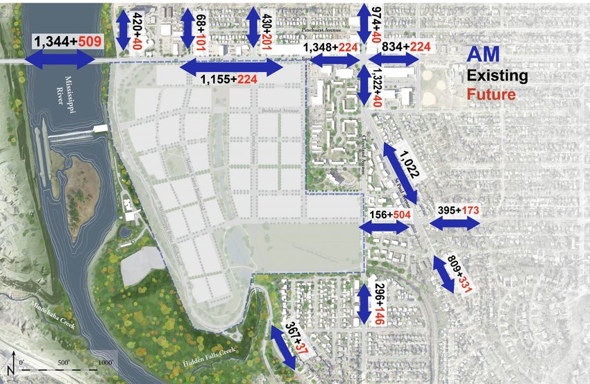
NOVEMBER 2016 42Vehicular Volumes at AM Peak Hour
NOVEMBER 2016 43Vehicular Volumes at PM Peak Hour
NOVEMBER 2016 44Existing Intersection Level of Service
A
A A A A A C
A
A
A A
NOVEMBER 2016 45After-Development Intersection Level of Service
A
A A B C A C
A
A
B B
A
NOVEMBER 2016 46Existing Intersection Level of Service
A
A A A B B D
A
A
A B
NOVEMBER 2016 47After-Development Intersection Level of Service
A
A A B C B D
A
A
B B
A
NOVEMBER 2016 48Planned Intersection Improvements
Intersection Improvements
Signalize intersection
Ford Parkway/
Provide NB/SB Left-turn lanes
Mount Curve Boulevard
Extend WB left-turn lane
Add NB left- and right-turn lanes*
Ford Parkway/ Extend WB left-turn lane
Cretin Avenue Remove part of the median
EB right-turn lane*
Cleveland Avenue/ Signalize intersection
Montreal Avenue Add west leg
Signalize intersection
Montreal Avenue/
Requires removal of part of the median
St. Paul Avenue
EB/WB left-turn lanes
Cleveland Avenue/
Optimize signal timing
St. Paul Avenue
* May Impact Pedestrian/Bicycle Environment. Future Discussion Required.
NOVEMBER 2016 49Planned Intersection Improvements
Intersection Improvements
Signalize intersection
Ford Parkway/
Provide NB/SB Left-turn lanes
Mount Curve Boulevard
Extend WB left-turn lane
Add NB left- and right-turn lanes*
Ford Parkway/ Extend WB left-turn lane
Cretin Avenue Remove part of the median
EB right-turn lane*
Cleveland Avenue/ Signalize intersection
Montreal Avenue Add west leg
Signalize intersection
Montreal Avenue/
Requires removal of part of the median
St. Paul Avenue
EB/WB left-turn lanes
Cleveland Avenue/
Optimize signal timing
St. Paul Avenue
* May Impact Pedestrian/Bicycle Environment. Future Discussion Required.
NOVEMBER 2016 50Planned Intersection Improvements
Intersection Improvements
Signalize intersection
Ford Parkway/
Provide NB/SB Left-turn lanes
Mount Curve Boulevard
Extend WB left-turn lane
NOVEMBER 2016 51Planned Intersection Improvements
Intersection Improvements
Add NB left- and right-turn lanes*
Ford Parkway/ Extend WB left-turn lane
Cretin Avenue Remove part of the median
EB right-turn lane*
* May Impact Pedestrian/Bicycle Environment. Future Discussion Required. NOVEMBER 2016 52Walking and Biking Network
NOVEMBER 2016 53Bike/Pedestrian Intersection Level of Service
Bicycle Level of Pedestrian Level of
Service Service
With With
Existing Existing
Intersection Recommended Recommended
Configuration Configuration
Improvements Improvements
Ford Parkway/ Mississippi River
Boulevard Access Ramps (North C (55) C (68) B (88) A (98)
and South ramps at Ford Pkwy)
Ford Parkway/ Woodlawn Avenue D (52) C (58) C (69) B (76)
Ford Parkway/Mount Curve Blvd D (52) B (75) C (69) B (78)
Ford Parkway/Cretin Avenue D (48) B (74) C (68) B (75)
Ford Parkway/ Finn Avenue E (30) C (60) C (68) B (81)
Ford Parkway/ Cleveland Avenue D (49) C (71) C (73) B (83)
Cleveland Avenue/ Saint Paul
D (50) C (67) C (68) B (79)
Avenue
Cleveland Avenue/Montreal Avenue C (55) B (75) B (90) A (94)
Saint Paul Avenue/Montreal Avenue D (49) B (79) C (70) B (87)
E. 46th Street/46th Avenue S.
D (40) C (60) C (72) B (75)
(Minneapolis)
Davern Street/Montreal Avenue D (53) B (75) B (80) B (89)
NOVEMBER 2016 54Questions and Answers
Topic Tables
1. Traffic Study – Overview
2. Traffic Study – Method
3. Traffic Study – Traffic Counts
   and Intersections
4. Traffic Study - Results
5. Corridor Sections                How to engage:
6. Transportation Network           • Circulate among the tables
7. Vehicular Network                • Consider the topic at each
8. Bike-Ped Network                 • Ask questions or chat with
9. Parking System                     the table facilitator and
                                      others at the table
                                    • Provide input, if desired

                                                              56
Future meetings Ford Zoning, Public Realm and Transportation Meeting Wednesday, November 30 6:30 – 8:00 p.m. Summit Brewing Ford Task Force Meetings Monday, December 5 Monday, December 12 6:30 – 8:30 p.m. St. Luke Lutheran 1807 Field Ave
Stay Connected

   stpaul.gov/21stCenturyCommunity
   ■ Provide input at Open St Paul - Ford
   ■ Sign up for E-newsletters & Notifications
   ■ Go to source for information on the project

   Facebook.com/cityofsaintpaul

   @cityofsaintpaul
Thank You!

           Ralph DeNisco

       617-279-0932
RDeNisco@nelsonnygaard.com

 NELSON\NYGAARD CONSULTING ASSOCIATES © 2016
You can also read