CHAPTER 9: INSIDE THE WORLD'S LARGEST DRONE ARCHAEOLOGY PROGRAM
←
→
Page content transcription
If your browser does not render page correctly, please read the page content below
CHAPTER 9: INSIDE THE WORLD’S LARGEST
DRONE ARCHAEOLOGY PROGRAM
FAINE GREENWOOD
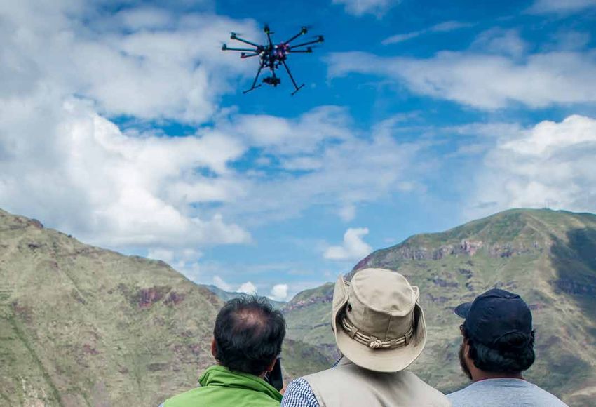
One overcast day in April 2015, Aldo Watanave took the train done with the mapping when the drone’s battery ran low;
to Machu Picchu.1 Watanave had with him an eight-rotored he landed it to swap in a fresh battery. As he launched the
drone, which he planned to use to photograph a stretch of drone again, a French tourist, disturbed by the aircraft,
the well-trafficked tourist road leading to Machu Picchu. started shouting at him. The shouting distracted Watanave,
From those photographs, Watanave would create a contour- who gasped as the drone came precariously close to a
line map. This map would help engineers determine the nearly invisible power line strung over the road. He tried
placement of a new museum, slated to be built away from to navigate away, but the drone took a sharp turn to the
the current road. right, neatly clipping a propeller on the power line. Now
impossible to control, the drone veered to the left at high
Watanave and his colleagues from Peru’s Ministry of
speed, plummeting into some bushes on a ledge above the
Culture arrived in Aguas Calientes, the rail terminus
river.
nearest Machu Picchu. From an open spot near a busy road
bridge over the Urubamba River, which rushed about 10 The road to Machu Picchu was just one of hundreds of sites
feet below, Watanave launched the team’s DJI Spreading that the Peruvian government archaeologists had mapped
Wings S1000 octocopter, a $1,999 commercial off-the-shelf since the drone program at the Ministry of Culture began in
drone. Watanave would pilot the drone while another team August 2013. The team mapped 180 sites in 2014, and had
member controlled the camera.* A third colleague followed managed to map 222 more by June 2015. As Peru is estimated
the drone on the ground with a surveying system,† which to harbor about 100,000 archaeological sites, according to
he used to gather GPS coordinate information that they government sources, the drone team has thus far focused
would later cross-reference with the photographs to create on smaller sites and on those at particular risk of being
a geographically accurate map. damaged in the wake of Peru’s current housing boom.
Watanave flew the drone over the bridge using a first-person The scale of the experiment, says program founder Dr. Luis
view system that allowed him to see real-time video footage Jaime Castillo Butters, proves that collecting useful data
from the drone on a small monitor. He was about halfway with a drone requires neither unique technical skill nor
a particularly huge budget. The team’s success, he says,
* A Sony NEX-7 24.3 MP camera mounted on a DJI Zenmuse Z15 gimbal stems from their determination to keep flying as often as
† Trimble R8 GNSS System they can, despite inevitable setbacks. “We’re not experts.
Observation huts on the outskirts of Machu Picchu, Peru’s most popular tourist attraction.
(All photographs in this chapter are by Faine Greenwood)
DRONES AND AERIAL OBSERVATION 79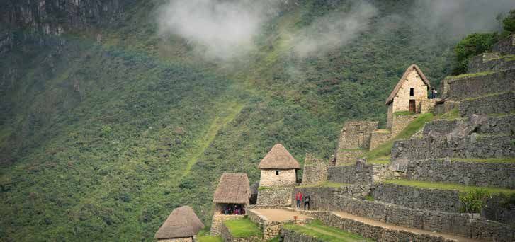
We don’t build drones, we don’t build engines, we don’t
build anything,” Castillo explains. “We simply use this
technology—but we use it a lot.”
The Ministry of Culture’s UAV mapping efforts haven’t gone
unnoticed by other branches of the Peruvian government.
The UAV team recently assisted Peru’s Superintendencia
Nacional de Bienes Estatales (SBN), which regulates state
assets, with mapping a nationally owned beach that was
being encroached upon by private development. The
SBN, says Watanave, was able to use the drone imagery
to document places where private homes had been built
illegally—information that can be used to more effectively
enforce the rules. The agency is now considering a drone
program of its own.
Castillo, an archaeologist who served as Peru’s vice minister
of cultural heritage from 2013 to May 2015, came up with
the project when he was a professor at Lima’s Pontificia
Universidad Católica.2 Castillo has been excavating on Peru’s
northern coast for 25 years. He’s long been a proponent of
using new technologies to study pre-Columbian cultures.
In his lab at the university, Castillo had been involved in
a project using X-ray fluorescence spectrometry to analyze
the chemical composition of ancient pottery.3 That analysis
could pinpoint where a particular pot came from, determine
what it was used for, and ferret out forgeries.
Castillo began contemplating the potential of UAV
technology for archaeology in 2011, when he began a
year-long stint as a fellow at Dumbarton Oaks, a Harvard
research institute in Washington, D.C. Steve Wernke, an
archaeologist at Vanderbilt University in Nashville, had
already been flying drones in the Colca Valley of southern      Aldo Watanave with an S-1000 drone at the Pisaq archaeological site
Peru, and Castillo became intrigued by Wernke’s efforts.        A local UAV specialist claimed he would teach them to fly
While still in Washington, Castillo purchased a Parrot AR       but seemed loath to give up the controls. Castillo eventually
drone for $300 from Radio Shack, familiarizing himself with     lost his patience. “I told the guy, ‘You know what, even if
the controls. He returned to Peru, and in April 2013 decided    I crash the damn thing, I’m going to fly it—because this is
to purchase a drone in a joint effort with Jeffrey Quilter, a   why I bought it,’“ he remembers. “That bring us to one point
Harvard archaeologist. Castillo bought two DJI drones:          I consider to be important: being independent, having the
a Spreading Wings DJI S800, designed for professional           capacity to do your own stuff.”
photography and video work, and a cheaper DJI Phantom
1. During the summer of 2013, Castillo and Watanave—who         Watanave and Castillo tweaked the DJI drones to suit Peru’s
had come to study under him in Lima—first learned to fly the    often difficult field conditions. They built their own sand-
two drones, then how to tinker with them to do archaeology.     resistant gimbal for the S800 and swapped out the GoPro
                                                                camera that came with the Phantom 1 for a lightweight
At El Tigre mountain, in the Amazonas region of northern        point-and-shoot Nikon camera, to remove the distortion
Peru, they used the Phantom 1 to photograph 23 previously       that the GoPro’s extreme wide-angle lens introduced.
undiscovered sarcophagi belonging to the pre-Incan
Chachapoyas culture,4 saving them the trouble (and              With these modifications in place and with increasing
potential danger) of climbing the high cliffs where the         confidence in their flying ability, Castillo and Watanave
artifacts had been placed. They also began to develop a         were able to begin their experiment in 3D drone mapping
method of using the larger DJI S800, equipped with a Sony       in earnest, heading to the north coast of Peru and flying
Alpha NEX-7 mirrorless camera, to create photographic           the devices on a daily basis. In August 2013, Castillo was
maps of some of the archaeological sites they worked on.        appointed Peru’s vice minister of cultural heritage, and he
                                                                brought the drone program with him, setting up his UAV
When they started, the small team of drone specialists          laboratory inside the Ministry of Culture building. By the
had plenty to learn. The team, Castillo relates, seriously      end of 2013, the team was making new drone maps weekly.
overpaid a local specialist to assemble the DJI S800, which
Castillo brought back from the U.S. in its component parts.     Peru places great stock in its archaeological heritage, and
                                                                some sites are particularly beloved by foreign visitors.
80   DRONES AND AERIAL OBSERVATION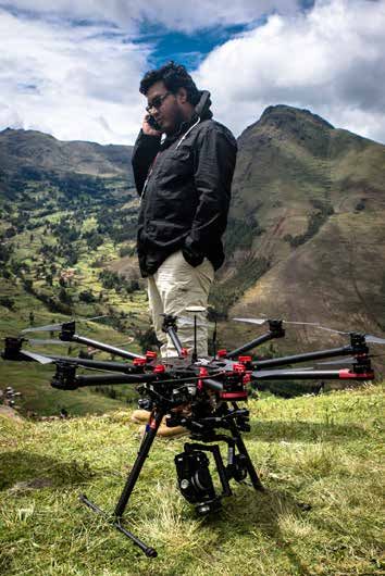
Peruvian officials estimate that over 3.8 million foreign        missions. With the assistance of GIS (geographic
tourists will arrive each year by 2016. The travel and tourism   information system) tools and Agisoft PhotoScan software,
sector makes up a significant part of Peru’s GDP: A 2013         the raw imagery is used for a variety of archaeological
World Economic Forum report found the direct contribution        applications—from simple documentation to damage and
                                                                 threat assessment. Besides doing science, the team hopes
of the sector to overall GDP came to 3.4 percent, and was
                                                                 to educate the public by using drone images. They add the
as large as 9 percent when indirect contributions were           imagery they collect to the ministry’s existing geographical
considered.5 These tourists will arrive in a country that        and georeferenced database of archaeological sites,
had just begun to experience an economic slowdown as of          known as SIGDA (Sistema de Información Geográfica de
2014, after a period of rapid growth averaging 6.4 percent       Arqueología). The group hopes that the resulting 3D maps
per year from 2003 to 2013.6 Peru’s poverty levels are also      and photographic data will be freely available to the public
dropping, to 22.7 percent in 2014 from 30.8 percent in 2010.7    sometime in 2015.
While the expanding economy has bolstered the spirits of
investors and consumers, it has also ushered in a boom           When working with the DJI S1000, Watanave says, it takes
in construction and development, as Peru’s increasingly          the team about 10 to 20 minutes to fly over and satisfactorily
prosperous population demands more and better housing.           photograph a hectare of land (2.47 acres), subject to
                                                                 variables including wind speed, weather, and altitude. In a
Archaeologists are well aware that increased demand for          good week, he reports, the team can map four sites a day. The
housing can have dire consequences for archaeological
                                                                 mapping UAVs have been equipped with Sony Alpha NEX-
sites in areas ripe for development. Sometimes the results
are particularly embarrassing. In June 2013, a 4,000-year-       7 mirrorless cameras, which have 24.3 megapixel sensors
old pyramid at the El Paraiso ruins near Lima was                and swappable lenses. The archaeologists typically set the
destroyed by two private construction companies, Alisol          cameras to an aperture of f/6.3, which gives them deep depth
and Provelanz. Police had to intervene to stop the company       of field, and use the camera’s automatic features to select
from destroying three more pyramids.8 The incident, which        a shutter speed between 1/200th and 1/600th of a second,
made international headlines, was a reminder to Peru’s           fast enough to minimize the blur induced by the drone’s
government that it lacked important information on the           motion. The camera is fired off every two to three seconds
boundaries and dimensions of its many archaeological
                                                                 by either an automatic timer or remote control in order to
sites. While thousands of sites were in the Ministry of
                                                                 shoot enough images to create orthomosaic (geometrically
Culture’s databases, the ministry lacked precise visual
information, making it difficult to determine which places       corrected) maps and three-dimensional models.*
were being threatened by development. There was also the         The team flies the UAV at a relatively low altitude during
problem of tracking damage that had already occurred, a          their mapping missions, usually between 70 and 100 meters
process that Castillo and Watanave say was difficult with
                                                                 (230 to 328 feet) above ground level, depending on the size
imagery captured only from the ground.
                                                                 of the site and the ground resolution they want to achieve.
Given the lack of accurate and legally useful data about the     With the focal length of the NEX-7 camera’s lens set at 16
exact boundaries of these archaeological sites, developers
                                                                 mm, Watanave says, they are able to achieve a ground
could easily claim ignorance if they built over a site,
                                                                 resolution of 1 to 1.5 centimeters per pixel at an altitude
insulating them from criminal consequences. Drones,
Castillo realized, might be able to help. Since Castillo
established his team in 2013, it has expanded to eight           * Most drone mappers prefer to take pictures at automatic intervals, but
                                                                 Watanave says he likes to use FPV (first-person view) video to align
staff members, including pilots, drivers, and computer           his pictures.
technicians. Castillo has also opened regional offices in
Cusco and in northern Peru, each with its own stock of
drones. The team now has seven DJI S1000 octocopters and
33 small DJI Phantom quadcopters, with an annual budget
of about $150,000, Castillo says.
Watanave travels the country and trains new drone pilots
and aerial imagery specialists within these regions, adding
to the pool of capable Peruvian UAV specialists. The
easy-to-fly Phantom 2s are particularly popular among
archaeologists new to UAV flight, who use them to shoot
video and general overviews of the sites they work on.
The drone team says they’ve mapped more than 500 sites in
the past two years, a considerable improvement over slower
ground surveying techniques. The UAVs have also spared
them the cost of hiring pilots to fly manned photography         Members of the Peruvian drone mapping team check battery levels before
                                                                 flying over the road leading to Machu Picchu.
                                                                                                      DRONES AND AERIAL OBSERVATION         81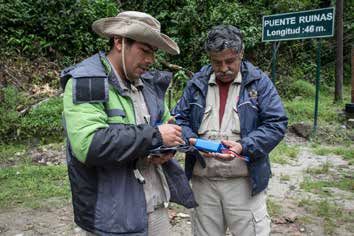
of 70 meters, which drops to 2.1 to 2.3 cm per pixel at an       (global navigation satellite system) ground surveying
altitude of 100 meters.                                          system, which can measure position to within 1 cm
                                                                 accuracy, the team collects multiple ground control points
Mapping is constrained primarily by the brief battery life of
                                                                 in the area they intend to fly over. After the flight is over, the
multi-rotor UAVs, which are less mechanically efficient than
                                                                 ground control points are entered into Agisoft PhotoScan
airplane-like fixed-wing drones. The DJI S1000 octocopter
                                                                 processing software, which uses them to accurately render
is able to fly for only about seven to 15 minutes, while the
                                                                 the map.
smaller DJI Phantom models can fly for a notional maximum
of 25 minutes. (Endurance for both models depends on the         IMAGE PROCESSING
weight of the payload, but the smaller quadcopter generally
can stay in the air longer.) Flight time is also dependent on    First, the researchers enter their images into Agisoft
altitude: At lofty sites in Peru’s mountains, it is harder for   PhotoScan, which will process them into a textured 3D
the UAV motors to function, cutting operational times by         model, which can then be converted into a georeferenced
about half.                                                      two-dimensional map, or orthophoto.
                                                                 The team enters these maps into the Ministry of Culture’s
The ministry’s interest in collecting 3D information about
                                                                 archaeological database. Researchers can use the database
structures is one reason why it currently uses only multi-
                                                                 to create other types of maps and models , such as contour
rotor UAVs, with their shorter battery lives, instead of
                                                                 maps, digital elevation models, and digital terrain models.
longer-flying fixed-wing UAVs. “The advantage of the
                                                                 The resulting data can be used to infer which portion of a
[multi-rotor] drone if you are going to record the buildings
                                                                 site might be likely to collapse soon, or where potentially
is that the drone hovers ... It doesn’t just take pictures
                                                                 damaging water tends to collect inside weakened walls.
from above, what we call ‘sentinel’ [vertical] pictures. It
also takes lateral pictures,” Castillo explains. “When you       The 3D data, with its added spatial information, can be an aid
can create a 3D model, you can show people where the             to exploration. Ministry of Culture researchers have already
excavation should be done,” says Watanave, explaining            used the 3D maps to identify new places to dig, including
the technique’s benefits over more traditional 2D mapping        a site in downtown Lima, Huaca Mateo Salado. The site
practices. To create a 3D map, the UAV is flown over the site    comprises five monumental and crumbling pyramids, some
with the camera set at a vertical or “sentinel” angle, while     parts of which date to 1100 B.C. The eroding, earth-colored
a second pass over the site is flown with the camera at a        stone of the site rubs shoulders with single-family homes
45 degree angle. The two perspectives are then combined          and a busy roadway.
in Agisoft PhotoScan processing software, which uses             Large sites can take hours to process, even with the relatively
GPS data to create a georeferenced and spatially accurate        powerful workstation computers in the Ministry of Culture’s
model. With 3D data, the archaeologists can create maps          laboratory. A model with 300 images takes three to four
that show multiple sides of a single building, carry out         hours to process in Agisoft PhotoScan with the laboratory’s
accurate measurements, and assess the volume of the site—        computer, which has 32 GB of RAM and a 4 GB graphics
permitting them, for example, to better anticipate where         card. The resulting files can be as large as a gigabyte, with
water might pool in a given ruin or determine where illegal      most averaging around 600 MBs. The team is working to
digging has taken place.                                         resolve this issue of size—to accomplish its goal of making
Though the cameras take high-resolution images of the            the files available to the public online.
scenery below, the resulting images don’t have a GPS             “From my stance and for my purposes, I think we should
frame of reference, which must be added to create a              have this as open-source, open public data,” says Castillo,
geographically accurate map. While some UAV mappers              who hopes the ministry can launch a publicly available
use GPS coordinates taken from cameras or onboard GPS            database of 3D-mapped archaeological sites sometime in
loggers to record the location where each photo was taken,       the summer of 2015. “They can download the raw data, and
the archaeologists need to create maps with centimeter-level     build their own models, and start working with the sites for
precision for the demands of their scientific research and       their own purposes.”
to properly record the boundaries of each archaeological
site. (The GPS information from the camera specifies, with       Preventing people from encroaching on archaeological
some margin of error, the position of the camera itself at       sites has become a major priority for the Ministry of
any given time, but does not unambiguously locate points         Culture’s UAV program. Although the program was initially
in the image.)With geographically accurate data, the maps        conceived of primarily as a recording project, the drone
make a better case for a given site’s exact location—another     team soon realized that the imagery was catching some
deterrent to illegal but hard-to-catch encroachment.             abusers of archaeological land in the act. “Always, when we
                                                                 fly the drone over an archaeological site, we catch people
To achieve this level of geographical accuracy, the Ministry     who live in the site, or throw garbage inside the site, or we
of Culture’s UAV mappers take ground control points,             see homeless people living inside the archaeological site.
which are accurately surveyed locations that can be used         It’s terrible,” Watanave says. As an example of the type
as a reference for the entire map. Using a Trimble R8 GNSS       of abuses the imagery can catch, Watanave cited a high-

82   DRONES AND AERIAL OBSERVATION
AUTONOMOUS VERSUS MANUAL FLIGHT
Many UAV mappers use autopilot software to fly drones semi-autonomously. But Castillo and Watanave prefer to fly their
aircraft themselves. Weather shifts quickly and software is unreliable, they say, and they often lack the large takeoff and
landing areas required by a fixed-wing UAV. They keep their UAVs in their sight at all times, allowing them to anticipate trouble
and react more quickly if there is a problem.
“We see the thing at every point, and we can control it,” says Castillo. “If anything goes wrong, we can actually try to do
something about it. When you fly a fully automatic mission, you are brainless. It comes down, and hopefully, you can recover
it. These things fail, they always fail. You have to be ready to take the punch.”
The team learned that lesson the hard way at the end of 2014, when a DJI S800 EVO mapping UAV was being flown autonomously
over the dusty Huaca Mateo Salado archaeological site in Lima’s leafy and heavily residential San Miguel district. While in the
middle of a flight, the drone lost communication with its GPS points, flying erratically and eventually crashing near the homes
and businesses that surround the pre-Hispanic pyramid. It was a nerve-wracking experience for the team, who take great
pains to avoid flying drones too close to other people or non-archaeological structures.
“It was strange because the GPS points inside the computer were excellent, but in one moment, the GPS was lost,” Watanave
says of the incident. He has never figured out the exact cause of the GPS failure, but ever since, the team hasn’t used
autonomous navigation for their mapping flights. They repaired the drone, but don’t use it much. However, Watanave says he
is open to experimenting with it again as the systems improve. -Faine Greenwood
resolution map of the Huacoy archaeological site, on the Many Peruvians were outraged, not least Castillo, who
Chillón River north of Lima, which is estimated to date arranged for one of the Ministry of Culture’s drones to fly
to 500 B.C. Newly built homes are encroaching upon the over the area to assess the damage. The aerial footage, which
crumbling and ghostly structures of the site—the exact kind showed damage from the banner and from Greenpeace
of development the Ministry of Culture hopes to prevent. members’ footprints in the soil around the geoglyph, was
broadcast on the PBS “NewsHour” television program in the
“People say to us, ‘We are poor, we don’t have land for our
United States.9 Greenpeace Executive Director Kumi Naidoo
house.’ But it’s not poor people doing this,” Watanave says
traveled to Lima to apologize. “I came to Peru in the wake
of the encroachment, pointing out that the aerial imagery
of the Nazca Lines activity to offer my full apologies to the
revealed swimming pools behind high walls. “People aren’t
people of Peru and all of those who have been shocked and
satisfied with having a piece of land that sits next to a site.
offended,” Naidoo said in a December 2014 press release on
They decide the site is also mine, and they start cutting and
the Greenpeace website.10 “This activity showed Greenpeace
building the stuff there,” Castillo says of the encroachment
in a terrible light. It is simply not what Greenpeace is,” he
the drone imagery has captured. Frustratingly for the
added.
archaeologists, simply documenting an encroachment
isn’t enough to stop it. Some people have lived at the site Castillo hopes that the drones will be able to serve as a
for years and can’t realistically be asked to leave. In other deterrent to businesses and individuals that in the past
cases, there’s simply little way to stop the damage. might have been able to get away with the illegal destruction
of archaeological sites, secure in the knowledge that there
It is clear that high-resolution drone imagery isn’t enough
was no effective way of documenting their activities. “If we
to protect archaeological sites. Enforcement of government
catch them, we can put them in such hot water that they
rules against encroaching on or damaging archaeological
start losing money by the bucket,” Castillo says.
sites has to accompany better data. That’s an uphill battle,
acknowledges Castillo, as both large businesses and The Ministry of Culture’s UAV project continues to expand
individual landowners come into conflict with cultural its scope, with plans to map larger areas using a long-range
patrimony, and as investors—both national and foreign— fixed-wing UAV. At the time of this writing, the ministry was
claim that an increasing amount of red tape is harming their considering acquiring a $25,000 SenseFly eBee mapping
investments in Peru. UAV, which could be used to more effectively map some
of Peru’s largest and most iconic sites, such as the ruins at
However, it’s not only illegal builders that are at risk of being
Machu Picchu and the extensive adobe remains of Chan
caught by aerial imagery. Greenpeace, the international
Chan in northwestern Peru, the largest pre-Columbian ruin
environmental group, found itself under scrutiny from
in South America.
the Ministry of Culture’s drones in December 2014, when
members of the organization unfurled a pro-sustainability As of June 2015, the Ministry of Culture’s drone program
banner near one of the massive and enigmatic Nazca Lines, seemed likely to continue into the future, with government
which are visible only from the air. Unfortunately, the backers recognizing its success and relatively unique nature.
Greenpeace members were unaware that the soil near the In May 2015, Castillo left government and returned to the
huge etchings in the earth is extremely delicate. university. Watanave, who has remained with the ministry,
DRONES AND AERIAL OBSERVATION 83is confident that the UAV program and the laboratory will tools for the public. receive funding to continue its research and field mapping efforts Castillo, for his part, is now advising the ministry Castillo is pursuing other experimental work using drones on the creation of a new technology center in Cusco, as well, including a recent project using synthetic aperture which will use new methods—including but not limited to radar and UAV technology to collect more detailed 3D drone mapping—for archaeological research. Castillo and images of the Nazca Lines. “The more we work, the more Watanave are contemplating how UAVs can be used beyond applications we find for UAV mapping, for things we hadn’t mapping work. It’s possible to use specialized UAVs to create even thought about,” he says. “Anybody can work with the indoor images and videos, a notion that inspired Castillo to drones,” Castillo notes. “We are simply doing it on a scale recently buy a DJI Inspire 1 drone, a high-end filming tool that is actually having a real impact on cultural patrimony.” with relatively sophisticated sense-and-avoid capabilities.11 After Watanave’s octocopter crashed on the road below Castillo thinks it would be possible to fly the drone inside Machu Picchu, he and several colleagues scrambled up the certain historic locations, such as Peru’s wealth of colonial slope to find it. A train sped by on a bluff above them as churches. Castillo and Watanave hope to eventually use the they located the crash site. To their considerable relief, the Inspire 1, or a drone like it, to create detailed photographs drone was quite salvageable: a broken arm, some snapped- and perhaps even three-dimensional maps12 of the interior off props, and some other minor damage. The drone could of these structures. These could be used for archival and be repaired in Lima without too much trouble. Watanave research purposes, and to create immersive educational and his drone would fly again. § Members of the Peruvian Ministry of Culture UAV mapping team looking at their drone as it maps Pisaq, an archaeological site in Peru’s Sacred Valley.
ENDNOTES

1    Much of this chapter is derived from author interviews with Aldo Watanave and
       Luis Jaime Castillo Butters in March and April 2015.
2    “Luis Jaime Castillo Butters,” Pontificia Universidad Católica del Peru, http://www.pucp.edu.pe/luis-castillo-butters/.
3    Nino Del Solar, Philipp Dollwetzel, Rémy Chapoulie, Luis Jaime Castillo, “Two pre-Columbian Pottery Productions of the Peruvian
        North Coast: An Archaeometrical Approach to Understand Technical Traditions of the Mochica and Cajamarca Cultures,” (paper
        presented at the 40th International Symposium of Archaeometry, Los Angeles, CA, March 16 2015), http://www.researchgate.
        net/publication/273633593_Two_pre-Columbian_Pottery_Productions_of_the_Peruvian_North_Coast_An_Archaeometrical_Ap-
        proach_to_Understand_Technical_Traditions_of_the_Mochica_and_Cajamarca_Cultures.
4    W. Alejandro Sanchez, “Peru Uses Drones for Archeological Projects,” Peru This Week, July 21, 2014, http://www.peruthisweek.
        com/news-peru-uses-drones-for-archeological-projects-103444.
5    Thea Chiesa, Roberto Crotti, Klaus Lengefeld, “The Peru Travel & Tourism Competitiveness Report 2013,” World Economic Forum,
       April 23 2013,http://www3.weforum.org/docs/WEF_TT_Peru_CompetitivenessReport_2013.pdf
6    “Peru’s Humala Brushes Aside Worries Over Economic Slowdown,” Reuters, March 2, 2015, http://www.reuters.com/arti-
       cle/2015/03/02/peru-economy-humala-idUSL1N0W42K420150302.
7    Teresa Cespedes, “Poverty Reduction Slows in Peru as Economic Growth Falters,” Reuters, April 23, 2015, http://www.reuters.com/
        article/2015/04/23/us-peru-economy-poverty-idUSKBN0NE2ES20150423.
8    Nuño Dominguez, “Researchers lament destruction of ancient Peruvian pyramid,” Nature, July 9 2013, http://www.nature.com/news/
       researchers-lament-destruction-of-ancient-peruvian-pyramid-1.13359
9    “Activist Stunt Disturbs Peru’s Treasured Archaeological Site,” YouTube video, 6:01, from a news segment by PBS NewsHour on De-
        cember 15, 2014, posted by “PBS NewsHour,” December 15, 2014, https://www.youtube.com/watch?v=lh1_q0P-EHk.
10    “Greenpeace Offers Apology for Nazca Lines Action,” Green Peace, http://www.greenpeace.org/international/en/news/features/
        Nazca-Timeline/.
11   Signe Brewster, “The DJI Inspire 1: Finally, a Drone that Flies Well Indoors,” Gigaom, December 20, 2014, https://gigaom.
       com/2014/12/20/the-dji-inspire-1-finally-a-drone-that-flies-well-indoors/.
12    William Morris, Ivan Dryanovski, and Jizhong Xiao, “3D Indoor Mapping for Micro-UAVs Using Hybrid Range Finders and
       Multi-Volume Occupancy Grids,” (paper presented at the RSS 2010 Workshop on RGB- D: Advanced Reasoning with Depth Cam-
       eras, Zaragoza, Spain, June 27, 2010), http://mobilerobotics.cs.washington.edu/rgbd-workshop-2010/papers/morris-RGBD10-3D-
       indoor.pdf.

                                                                                                           DRONES AND AERIAL OBSERVATION   85
You can also read