Chemical weathering indices applied to soils developed on old lake sediments in a semi-arid region of Turkey - DergiPark
←
→
Page content transcription
If your browser does not render page correctly, please read the page content below
T. Tuncay et al. / Eurasian J Soil Sci 2019, 8 (1) 60 - 72

Chemical weathering indices applied to soils developed on old
      lake sediments in a semi-arid region of Turkey
Tülay Tunçay a, Orhan Dengiz b,* , Ilhami Bayramin c, Seref Kilic d, Oguz Baskan a
                a Soil
                   Fertilizer and Water Resources Center Research Institute, Yenimahalle, Ankara, Turkey
    b Ondokuz Mayıs University, Faculty of Agriculture, Department of Soil Science and Plant Nutrition, Samsun, Turkey
       c Ankara University, Faculty of Agriculture, Department of Soil Science and Plant Nutrition, Ankara, Turkey
        d Ardahan University, Faculty of Engineerinf, Department of Environmental Engineering, Ardahan, Turkey

                               Abstract
                               Climate is a major influence on weathering processes affecting soil parent materials.
                               Important contributors to soil formation in arid and semi-arid climatic zones are the
                               diurnal cycles of solar heating and cooling that cause mechanical or physical
                               disintegration of rock or parent materials, and wind-blown sands that score and abrade
                               exposed rock surfaces. By using the Soil Taxonomy classification system, the initial aim of
                               this study was to carry out a pedological evaluation for four soil profiles, classified as Xeric
                               Haplocalcid and Xeric Haplocambid, formed on different parent materials (limestone, marl
                               and old alluvial deposits) under the same conditions, including topography and
                               vegetation, in a semiarid region. The second stage was the exploration of the similarities
                               and differences in the classifications resulting from either the pedogenic processes, or
                               from other factors, by determining the degree of soil weathering using geochemical data.
                               To achieve this, soil samples were collected from the horizons to investigate their
                               mineralogical, geochemical and physiochemical properties. The study also considered
                               other features, such as the pedogenic evolution of soils, through the use of weathering
                               indices, namely the Chemical Index of Alteration (CIA), Chemical Index of Weathering
                               (CIW), Base/R2O3 Ratio, Weathering Index of Parker (WIP) and Plagioclase Index of
                               Alteration (PIA). The results clearly showed that soil development at the Altınova State
Article Info                   Farm at Konya in the Central Anatolia region of Turkey is due to slow pr ogressive
                               weathering. For this case, the main indicators are secondary calcium carbonate illuviation
Received : 18.03.2018          and weak structural development with a weathering ratio of silicon to aluminium greater
Accepted : 11.12.2018          than two in all profiles.
                               Keywords: Alteration index, geochemical evolution, soil formation, dry region.
                                                             © 2019 Federation of Eurasian Soil Science Societies. All rights reserved

Introduction
To a pedologist or soil geographer, soil means a natural, three-dimensional body that has formed at the
Earth’s surface through the interactions of five soil-forming factors, namely climate, biota, relief, parent
materials and time (Schaetzl and Anderson, 2005), and a field mapper is often able to explain and predict soil
variation as a function of these five factors (Jenny, 1946; Johnson and Hole, 1994).
Soil formation is a dynamic rather than a static process, with soil developing where there is a dynamic
interaction between the air, water, parent material and organisms. Wherever one or more of these major
factors changes, the soil will be different. Significant differences in soil chemical, physical and morphological
properties, particularly in a small area, are known to be related to the dynamic interaction between

*Corresponding author.
Ondokuz Mayıs University, Faculty ofAgriculture, Department of Soil Science and Plant Nutrition, 55139 Samsun, Turkey
Tel.: +90 362 3121919                                                                          E-mail address: odengiz@omu.edu.tr
e-ISSN: 2147-4249                                                                                       DOI: 10.18393/ejss.499122
                                                                 60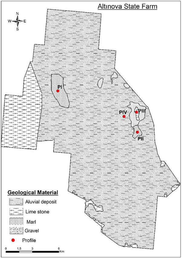
T. Tuncay et al. / Eurasian J Soil Sci 2019, 8 (1) 60 - 72
microclimate, topography and parent material (Lark, 1999; Dengiz et al., 2006), whereas the regional
processes, macroclimate and vegetation, are important at the continental scale (Lark, 1999).
Weathering can be described as the physical and chemical alteration of rocks and minerals on or near the
Earth’s surface (Pope et al., 2002). In physical weathering, also known as mechanical weathering or
disintegration, physical stresses combine to break rocks into smaller pieces. In contrast, water and oxygen are
important to many chemical weathering reactions. Chemical weathering indices estimate the intensity of soil
chemical weathering by comparing changes in major and trace metal concentrations as ratios of mobile to
immobile elements in soil and rock or parent material. (Duzgoren-Aydin et al., 2002; Price and Velbel, 2003).
These indices also provide a measure of the weathered state of the saprolite underlying the mobile soil
column. This weathered condition is likely to play a critical role in governing how physical processes disrupt
the saprolite, and is therefore an important parameter in determining resistance to alteration and erosion.
Weathering indices are conventionally calculated using the molecular proportions of the oxides of major
elements. Stoichiometrical changes during weathering are reflected in the index value. The molecular
proportion of each oxide is easily calculated from the percentage of the oxide based on weight. Vogt (1927)
proposed a geochemical method for assessing the maturity of residual sediments: the Vogt’s Residual Index.
The Chemical Index of Alteration (CIA) was proposed by Nesbitt and Young (1982) to quantitatively evaluate
the weathering history recorded in sediments and sedimentary rocks. The CIA has been used to evaluate
chemical weathering in specific drainage basins (McLennan, 1993; Yang et al., 2004). As the transformation of
feldspar to clay minerals and the coincident mobility of the main cations are belong to a major chemical
process, Parker (1970) proposed a more useful index known as the Weathering Index (WIP), which can
evaluate minor changes in Na+, K+, Ca2+ and Mg2+. The Chemical Index of Weathering (CIW) was initially
proposed by Harnois (1988). This index is similar to the CIA, except that it eliminates K 2O from the equation.
The Plagioclase Index of Alteration (PIA) was proposed by Fedo et al. (1995) as an alternative to the CIW.
Because plagioclase is abundant in silicate and dissolves quickly, the PIA may be used when plagioclase
weathering needs to be monitored.
The differences in soils are due to differences in variables such as parent material, topographical position,
slope steepness, distribution of moisture, vegetation, and age of the associated landscape (Birkeland, 1999;
Dengiz and Usul, 2018). Particularly, parent materials changes can affect many soil properties in local
condition due to their minerological and textural variation.
By considering weathering indices, geochemical and mineralogical data, the present study was a pedological
evaluation that aimed at identifying individual mineralogical and geochemical characteristics of aridisols with
different parent materials but located in a similar topographical position, with similar climatic conditions,
land use and vegetation. In addition, the second aim of the study was to determine how different parent
materials located on old lake sediments affect the morphology, minerology and physicochemical properties of
soils under similar conditions of topography and vegetation in a semi-arid region.
Material and Methods
The study site description
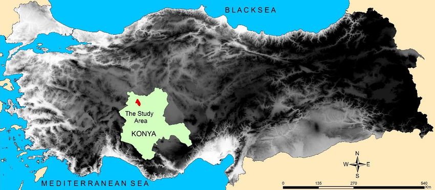
This study was carried out on an area of approximately 29608.6 ha in the Altınova State Farm, located
between eastern longitudes 421239–4535249 m and northern latitudes 488389–4272469 m (Universal
Transverse Mercator-UTM, WGS 84, 915 m) (Figure 1) in the middle of central Anatolia, Turkey. The farm is
located approximately 189 km from Ankara and about 126 km from Konya in the Great Konya Basin.
The pedological and geological properties of the soils and sediments, and the formation and diagenesis of
carbonates under the lacustrine environment in the Great Konya Basin, have been investigated (de Ridder,
1965; Driessen and de Meester, 1969; Driessen, 1970; Vergouwen, 1981). A geological map of the study area
is provided in Figure 2. The Great Konya Basin is predominantly occupied by Quaternary alluvial sediments
(de Meester, 1971). According to their reports, during some periods of the Late Pleistocene epoch, most of
the Great Konya Basin was covered by a shallow lake with a fairly constant water level of 12 to 20 m, which
left a number of sandy beach ridges and sand plains located roughly at the 1010 m contour. On top of the
soft-lime lake bottom, a large variety of other sediments were deposited, resulting in various physiographic
units, which divided the Great Konya Basin plain into uplands, colluvial slopes, piedmont plains, bajadas,
terraces, alluvial plains and lacustrine plains. The terraces of the flat Neogene limestone formation are
located along the fringes of the Great Konya Basin. The alluvial plains and fans comprise the sediments of
some rivers debouching into the southern part of the basin. In addition, Özaytekin et al. (2012a) reported
61
T. Tuncay et al. / Eurasian J Soil Sci 2019, 8 (1) 60 - 72

that the alluvial fans or inland deltas consist of sediments ranging from coarse sand to a heavy clay texture
while the lacustrine plains are flat and contain carbonates. Deposited under water, the lacustrine plains
cover vast areas in the centre of the Great Konya Basin. These ridges and shores were formed from the
continual washing of the former Pleistocene lake (Roberts et al., 1979).

                                               Figure 1. The study area
Over the long term (1999–2011), according to data from the State Farm’s meteorological station, the mean
annual precipitation is 302.3 mm, the total evapotranspiration is 1296.1 mm, and the mean annual
temperature is 12.8 °C. Soil temperature and soil moisture regimes at the study site were classified according
to the Soil Survey Staff as mesic and aridic (Soil Survey Staff, 1999), respectively. All farm land has been used
as dry farming.

                                     Figure 2. Geological map of the study area
                                                            62
T. Tuncay et al. / Eurasian J Soil Sci 2019, 8 (1) 60 - 72
Soil sampling
Soil samples were collected from four representative profiles in the State Farm. In geological terms, profiles I
and III were formed from hollow clay filler on Neogen old lake terraces and profiles II and IV were formed
from subcreek alluvion material on Neogen old lake terraces. The morphological properties of these four
profiles were described and sampled according to genetic horizons and then classified according to the Soil
Survey Manual (1993) and Soil Survey Staff (1999). A total of nineteen disturbed soil samples in total were
collected to investigate their physical, chemical and mineralogical properties in the laboratory. Soil samples
were air-dried and passed through a 2 mm sieve to prepare them for laboratory analysis.
Physical, chemical and mineralogical analysis
After the soil samples taken from four soil profiles were air-dried and passed through a 2 mm sieve. Particle
size distribution was determined with the hydrometer method (Bouyoucos, 1962). Organic matter was
removed with 30 per cent H2O2, sulphate was removed by leaching salts with distilled water, and carbonates
were removed with 1 M NaOAc at pH= 5 with dispersion, by agitating the sample in 10 ml of 40 per cent
sodium hexametaphosphate (Calgon) (Gee and Bauder, 1982). Bulk density was determined by using
undisturbed samples (Black, 1965). Soil organic matter was measured by Fe2SO4 titration of an acid-
dichromate digestion (Walkley and Black, 1934). The methods of the Soil Survey Laboratory (2004) were
used to determine the pH and EC (electrical conductivity) values of the saturated soil samples. CaCO3 content
was measured with a Scheibler calsimeter (Soil Survey Manual, 1993), and exchangeable cations and cation
exchange capacity (CEC) were measured with the 1 N NH4OAc (pH 7) method (Soil Survey Laboratory
Manuals, 2004).
The clay fraction (< 2 μm) was obtained from the soil after the organic matter was removed with dilute, Na-
acetate-buffered H2O2 (pH 5), followed by dispersal using calgon and sedimentation in water. Oriented
specimens on glass slides were analyzed with X-ray diffraction, using Cu Kα radiation from 2° to 15° 2θ, with
steps of 0.02° 2θ at two seconds per step. The following treatments were performed: Mg saturation, ethylene
glycol solvation (EG) and K saturation, followed by heating for two hours at 550°C. Minerals were identified
and their relative abundance was determined by their diagnostic X-ray diffraction (XRD) spacing and
evaluated by their XRD relative peak intensities in the XRD (Whittig and Allardice, 1986). Identification of
selected major, trace and rare earth elements was done with an Inductively Coupled Plasma Mass
Spectrometer (ICP-MS). Samples were taken into solution by alkaline fusion, using a mixture of 0.25 g soil or
powdered sediment and 0.75 g of flux (lithium tetra- and metaborate) in 0.2 N HNO3 solution diluted to
1:1000. An aliquot of the sample solution was analyzed for trace elements and the rare earth elements (REE)
on a combination simultaneous/sequential ICP-MS. Detection limits were 0.1 to 1.0 ppm for all major and
trace elements and 0.1 to 0.5 ppm for REE. The instrument was calibrated by using certified standard
reference materials (OREAS24P and G1). To better evaluate the nature of soils and sediments and the effect
of weathering and possible recycling of trace and rare earth elements in sediments under semi-arid
conditions, a reference sediment was used for comparison; a North American Shale Composite (NASC)
(Taylor and McLennan, 1985) was chosen for that purpose. All procedures were replicated three times for
each soil sample, and the mean values were reported (Chao and Sanzolone, 1992).
Calculation of weathering indices
Numerous indices, including those of Nesbitt and Young (1982) and Harnois (1988), have been developed to
characterize chemical weathering in soils. Those indices are similar in that they are based on the ratio of the
base cations (Ca, Mg, K and Na) to Al and Si. Weathering indices used to quantify chemical weathering
intensity in the current study included the Chemical Index of Alternation (CIA) (Nesbitt and Young, 1982),
Chemical Index of Weathering (CIW) (Harnois, 1988), Weathering Index of Parker (WIP), (Parker, 1970),
Bases/R2O3 Ratio (Birkeland, 1999), Plagioclase Index of Alteration (Fedo et al., 1995) and Product Index (P)
(Reiche, 1950). CaO* represents the CaO contained only in the silicate fraction and is corrected for carbonate
and apatite content. It is based on the assumption for CaO* that the molar CaO/Na 2O ratio of silicates is not
higher than one. As the molar CaO content (corrected for apatite) was less than the molar Na 2O content, the
value was taken as CaO*. On the other occasions, the CaO content of silicates was supposed to be equivalent
to the molar Na2O content (McLennan, 1993).
63T. Tuncay et al. / Eurasian J Soil Sci 2019, 8 (1) 60 - 72
Results and Discussion
Morphological properties and classification
A description of the study site and four representative soil profiles are provided in Table 1. All profiles were
from flat land, with profiles I and II formed on marl parent material, profile III formed on limestone, and
profile IV formed on an alluvial deposit (Figure 2).
Table 1. Selected site characteristics of pedons
Pedon Coordinates Parent Elevation Slope Slope Land cover
No East North Material (m) Position (%) Land Use
I 420723 4287966 Marl 989 Flat 0-0.5 Dryfarming
II 420025 4291459 Marl 988 Flat 0-1 Dryfarming
III 419884 4292524 Limestone 985 Flat 0-2 Dryfarming
IV 418202 4290775 Aluvial deposit 975 Flat 0-1 Dryfarming
Soils in the study area display variations in terms of particle size distribution, color and surface horizon
depth. Differences in the soils represent the effects of parent material because they developed under similar
climate, topographical position and land use-vegetation conditions. Profiles I and II developed on the marl,
while profile III developed on the limestone, as a result of decomposition and fragmentation of the
calcareous parent material. Secondary carbonate nodules were formed following the calcification process,
which provides evidence for carbonate leaching and accumulation in profiles I, III and IV, but not in profile II.
A cambic B horizon was initially found in each profile according to weak soil structure development and
light soil color. This result is consistent with previous research which found that a cambic horizon developed
along with a calcic horizon in soils of arid and semi-arid regions (Buringh, 1979; Boul et al., 1980; Dinc et al.,
1987). This effect and result was seen in profiles I, III and IV.
Soil color was closely related to the parent materials, namely marl and alluvial deposits, with a hue of 10YR
in profiles I, II and IV, and 7.5 YR in profile III. For all profiles, the soil had a weak or moderately developed A
horizon with a granular, angular, blocky structure; a weak or moderately developed B horizon with a
granular, sub-angular or angular blocky structure; and a C horizon with a massive structure (Table 2). Soil
Survey Staff (1999) classification system was used in this study. Profile I, formed on marl parent material on
the old Neogen lake terraces was classified as Xeric Haplocambid. The main diagnostic horizon in profile I
was the subsurface cambic horizon, resulting from structural development, observed especially at depths
between 21 and 72 cm. Common secondary carbonate nodules and micelles were observed at depths
between 72 to 107 cm. Profile II, on marl parent material on the old Neogen lake terraces, was classified as
Xeric Haplocambid. The main diagnostic horizon in profile II was the subsurface cambic horizon, resulting
from structural development, observed especially at depths between 41 and 75 cm. However, there was no
evidence of calcification and the calcic horizon evident in profile I. This finding indicates that profiles can
form different soil genetic horizons from similar parent materials. Profile III, which formed on limestone and
was classified as Xeric Haplocalcid, also showed a subsurface density diagnosic horizon, Ad, at depths
between 14 and 26 cm, due to intensive field traffic, and a subsurface cambic diagnostic horizon, Bw, at
depths between 75 and 96 cm. In addition, profile III showed the presence of secondary CaCO3 nodules and
mycelia at depths between 96 to 127 cm. Profile IV, which was formed on alluvial parent material, was
classified as Xeric Haplocambid. The main diagnostic horizons in profile IV were subsurface the cambic
horizons development observed at depths between 68 and 86 cm, and common carbonate nodules and
micelles at depths between 86 and 104 cm (Table 2). Therefore, the genetic order of profile IV is similar to
profiles I and III, although their parent materials were not the same.
Physical and chemical characteristics
The major physical and chemical properties of the soils in each profile in the study area are presented in
Table 3. Properties in the different profiles varied as a result of a dynamic interaction between climate and
parent material (Dengiz, 2010; Kibar et al., 2012). Solum depth ranged from 20 to 127 cm, depending upon
the degree of weathering and the stage of the soil formation process. All profiles had a moderately alkaline
soil (pH value range from 7.81 to 8.25) and a slightly soluble salt content, with no substantial differences
among them. The main reasons for particle size distribution differences between the soil profiles were the
differences in chemical and minerological composition in their parent materials, including rocks. The
dominant soil texture for profiles I, II and III was clay or clay loam, with the highest clay content in the Xeric
64T. Tuncay et al. / Eurasian J Soil Sci 2019, 8 (1) 60 - 72
Haplocalcid (profile III) developed on limestone parent material, and the highest sand content ranged from
60.16 to 66.39 % in profile IV which was formed on alluvial parent material.
Table 2. Morphological properties and classification (Soil Taxonomy) of pedons
Depth Color Color
Horizon Structure Boundry Special features
(cm) (dry) (moisture)
Pedon I (Xeric Haplocambid)
Ap 0-21 10 YR 5 /2 10 YR 4/2 1mgr as -
Bw1 21-45 10 YR 5/3 10 YR 4/3 1msbk gw structure development
Bw2 45-72 10 YR 5/6 10 YR 4/6 1msbk ga structure development
common carbonate nodules
Ck 72-107 10 YR 8/3 10 YR 7/3 mas ga
and micelles
C2 107-152 10 YR 8/4 10YR 7/4 mas - -
Pedon II (Xeric Haplocambid)
Ap 0-21 10 YR 5/3 10 YR 4/3 1fgr cs -
A2 21-41 10 YR 5/3 10 YR 4/3 1fgr cs -
Bw 41-75 7.5 YR 6/6 7.5 YR 5/6 1fgr cs structure development
C1 75-101 7.5 YR 7/6 7.5 YR 6/6 mas - -
C2 101-130 7.5 YR 7/6 7.5 YR 6/6 mas - -
Pedon III (Xeric Haplocalcid)
Ap 0-14 7.5 YR 4/3 7.5 YR 3/3 2fgr as -
Ad 14-26 7.5 YR 4/3 7.5 YR 3/3 mas gw -
A3 26-75 7.5 YR 5/3 7.5 YR 4/3 1cabk gw -
Bw 75-96 7.5 YR 5/6 7.5 YR 4/6 1mabk gw structure development
Bk 96-127 7.5 YR 6/6 7.5 YR 5/6 2mabk gw carbonate micelles
C 127-165 7.5 YR 6/6 7.5 YR 5/6 mas - -
Pedon IV (Xeric Haplocambid)
Ap 0-24 10 YR 4/2 10 YR 4/1 2mgr/ 1mabk gs -
A2 24-67 10 YR 4/3 10 YR 4/2 3mabk cw -
Bw 67-86 10 YR 5/4 10 YR 4/4 2mabk cw structure development
common carbonate nodules
Bk 86-104 10 YR 4/6 10 YR 4/4 1msbk ga
and micelles
C 104-150 10 YR 5/6 10 YR 4/6 mas - -
Abreviations: Boundary: a = abrupt; c = clear; g = gradual; d = diffuse; s = smooth; w = wavy; i = irregular. Structure: 1 =
weak; 2 = moderate; 3 = strong; sg = single grain; mas = massive; vf = very fine; f = fine; m = medium; c = coarse; gr =
granular; pr = prismatic; abk = angular blocky; sbk = subangular blocky
Soil Cation Exchange Capacity (CEC) varied from 14.3 to 56.8 cmolc kg−1, with the highest CEC in the Xeric
Haplocambid (profile II), in which smectite was the predominant clay type, indicating the presence of
stratified aluminosilicates with high load intensity. The lowest CEC value was found in soil classified as Xeric
Haplocambid (profile I). Ca and Mg were the dominant exchangeable cations in all profiles, with a base
saturation value of 100%. As there is little deposition and accumulation of organic litter in arid and semi-
arid zones, the organic matter content of the soils was low. When these soils are cultivated, the limited
organic matter content is quickly decomposed (Da Costa et al., 2015). For all profiles in the study area, the
organic matter content was highest (1.0 to 1.6 %) in the surface horizon and lowest in the subsurface
horizons (0.4 to 1.4 %), with an abrupt decrease in the subsurface horizon. The low levels of organic matter
in the subsoil can be attributed to the rapid decomposition and mineralization of organic matter.
Soil bulk density values ranged from 1.33 to 1.70 g cm–3, with values generally higher in the surface horizons,
especially Ap horizons, than in subsurface horizons, as a result of compaction by the relatively intensive field
traffic associated with agricultural activities. Profiles I and II were formed on the same parent material
(marl) but the CaCO3 content of these profiles was different; profile I had the highest CaCO3 content of
57.7%, and calcium carbonate accumulation in the calcic horizon. Profile IV developed on alluvial parent
material and had the lowest CaCO3 content of all profiles.
65T. Tuncay et al. / Eurasian J Soil Sci 2019, 8 (1) 60 - 72
Weathering indices and clay mineralogy
Chemical weathering indices are commonly used to quantitatively evaluate changes caused by chemical
weathering in different materials (Birkeland, 1999; Darmody et al., 2005; Vogt, 1927; Ruxton, 1968; Harnois,
1988). The indices are based on the principle that the ratio between concentrations of mobile (e.g. SiO2, CaO,
MgO and Na2O) and immobile (e.g. Al2O3, Fe2O3 and TiO2) elements will decrease over time as leaching
progresses. However, the weathering of heterogeneous metamorphic rocks confounds the understanding of
the relationship between the weathering index and depth (Dengiz et al., 2013).
Weathering indices calculated from elemental oxide concentrations in molecular proportions are also used
to evaluate the vertical changes in a weathering profile. In addition, generally, weathering indices change
systematically for soil profiles formed from homogeneous parent rocks with depth. In the current study, six
previously defined chemical weathering indices were used to evaluate four profiles under similar climatic
and topographic conditions. Major and minor element concentrations in the studied profiles, some
weathering rates obtained from the geochemical features of the soils, and some genetic rates, are provided
in Tables 4 and 5.
According to total element analyses showed that the SiO2 content in all profiles decreased with depth (range
of 52.32 to 25.40%) and that Al2O3 values varied from 4.99 to 13.11%. SiO2 strongly resists weathering
because it is mainly contained in quartz minerals. In contrast, Al2O3 is mainly is less resistant to weathering
because it is contained in the clay minerals; a high content of Al2O3 indicates a high content of clay minerals
(Shan et al., 2010). The highest amount of Fe2O3 (5.72%) was in profile II. These results are supported by
XRD analysis. In regions where the parent materials are mostly marl and limestone, elevated concentrations
of CaO and MgO are seen in the soils. Generally, the CaO content in these soils range from 1 to 11%, but in
some cases the CaO content increases to between 11 and 24%, or even higher (Alumaa et al., 2001).
The CIA index was proposed by Nesbitt and Young (1982) in the reconstruction of the paleoclimate from
Early Proterozoic sediments of the Huronian Supergroup, north of Huron Lake. The CIA is based on the
progressive removal of soluble cations (e.g. Ca, Na, and K) from minerals during chemical weathering, and it
reflects the proportion of primary and secondary minerals in the bulk sample (Nesbitt and Young, 1982).
Generally, rocks from the upper crust and unweathered igneous rocks have CIA values of ~ 50, whereas the
soils and sediments derived from intensely weathered rocks, and containing residual clay minerals such as
kaolinite and/or gibbsite, have CIA values approaching 100 (Fedo et al., 1995; Ao et al., 2010; Özaytekin et
al., 2012b). The value ranges from 70 to 75 for shale rock.
In the profiles examined in the current study, the CIA values varied from 6.60 to 66.88. The highest and
lowest CIA values were in the A and C horizons of the Xeric Haplocambid (profil IV and profile I),
66T. Tuncay et al. / Eurasian J Soil Sci 2019, 8 (1) 60 - 72
respectively. The CIA values decreased with depth in all profiles. In other words, the parent materials of all
profiles had the lowest CIA values of all layers. Nesbitt and Young (1982) classified the CIA values as very
slightly weathered (50 to 60), slightly weathered (60 to 70), moderately weathered (70 to 80), highly
weathered (80 to 90), and extremely weathered (90 to100).
When the CIA classification was applied in the current study, the surface horizons of all profiles, except for
profile IV, were classified as very slightly weathered. On the other hand, all subsurface horizons were in the
same class (very slightly weathered). In addition, there was no obvious trend towards progressively higher
alteration values for soils developed on different parent materials. Harnois (1988) proposed the Chemical
Index of Weathering (CIW) which modified CIA by excluding K2O from assessments. Because the CIW does
not account for the aluminium associated with K-feldspar, it may generate very high values for K-feldspar-
rich rocks, whether they are chemically weathered or not (Fedo et al.,1995).
67T. Tuncay et al. / Eurasian J Soil Sci 2019, 8 (1) 60 - 72
In the present study, the CIW values ranged between 6.68 and 78.37 and tended to decrease with depth in all
profiles. The value of CIW increased with weathering. If the classification for CIA is performed for CIW as
well, it is evident that all the profiles developed on different parent material are in similar classes in terms of
CIW values. This result indicates that the CIW and CIA indices display similar behaviour for the different
parent material.
The base/R2O3 values of all profiles ranged from 0.64 to 10.52. Parker’s Weathering Index (WIP) is used to
evaluate the intensity of the weathering of silicate rocks, based upon the proportion of alkali and alkaline
earth elements in the products of weathering. The WIP also takes into account some individual mobilities,
namely sodium, potassium, magnesium and calcium, on the basis of their bond strengths with oxygen
(Parker, 1970). According to the definition of WIP, smaller WIP values indicate stronger chemical
weathering, which is opposite to the manner in which CIA values are generated. This index has been
suggested to be most appropriate for application to weathering profiles on heterogeneous parent rocks and
is most likely not applicable to highly weathered mantles, because the assessment only includes highly
mobile alkali and alkaline elements (Hamdan and Burnham, 1996; Duzgoren-Aydin et al., 2002; Price and
Vebel, 2003). in In the present study, the WIP values of the soils formed on marl, limestone and alluvial-
deposit parent rocks were between 36.51 and 110.95, 45.26 and 66.25, 33.05 and 49.61, respectively, and
decreased with increasing weathering. The lowest WIP values were 33.05 in profile IV and 36.51 in profile II.
These profiles were determined to be Xeric Haplocambid, whereas the C horizon of profile I, which
developed on marl parent material, had the highest WIP value (110.95) and was deemed to be Xeric
Haplocalcid.
There are two explanations for this phenomenon. Firstly, it means that the weathering process is more
intense in Xeric Haplocambid profiles than in Xeric Haplocalcid profiles. Secondly, with time, the soil derived
from the parent material diverges progressively from that of the parent material under the influence of the
pedogenic process. In terms of parent material, the profile that developed on alluvial parent material
showed the highest weathering, with the P index varying between 81.67 and 84.94 and tending to fluctuate
slightly with depth in all profiles.
Fedo et al. (1995), proposed the Plagioclase Index of Alteration (PIA) as an alternative to the CIW. Because
plagioclase is abundant in silicate and dissolves relatively rapidly, the PIA may be used when plagioclase
weathering needs to be monitored (Fedo et al., 1995). In the present study, the PIA values tended to
decrease with the depth in all profiles, with the Vogt’s index value varying between 0.07 and 1.91. CIW
values also decreased with depth.
Another way to study the degree of chemical weathering of the soil profiles investigated was to calculate the
relative change in REE (Rare Earth Element) concentration. The abundance of trace elements and REEs in
sediments has been employed to provide clues as to both sources and changes in sediments from weathering and
sedimentary processes, as in Taylor and McLennan (1985). Some ratios of geochemical elements are used to
quantify the degree of weathering of studied profiles. The trace elements and REEs of the studied soils are
normalized to chondrite (Wood et al., 1979). Normalized REE patterns can indicate the degree of weathering of
materials and this also applies, to a lesser extent, to the light rare earth element fraction. In many studies of
weathering profiles, “immobile” elements such as Ti, Zr, Y and Nb, are used as internal references to evaluate the
mobility of other elements (Nesbitt, 1979; Moore, 1998; Hill et al., 2000). The geochemical methods include also
the determination of Th/U values. In the current study, the Th/U values ranged between 0.85 and 2.42 in all
profiles. The lowest value was seen in the genetic horizon Bw2 of the Xeric Haplocambid. In addition, the Ba/Nb
ratio ranged from 32.88 to 105.13. There was irregular change in profiles with depth, and the highest weathering
was in the Bk horizon of the Xeric Haplocalcid. There was a degree of substitution of Sr for Ca in CaCO3, and the
variation in (Rb+Zr)/Sr was between 0.15 and 0.65. There was a large variation of CaCO3 content in the profiles.
Ti and Zr are often considered to be almost immobile; immobile index elements such as Ti and Zr are often used
to identify enrichment or depletion of elements due to weathering and to calculate the mass balance relative
mobility of other elements and soil discontinuities. They supplement the elemental concentration ratios of
saprolite and parent bedrock to compensate for potential volume change during soil formation (Kabata-Pendias
and Pendias, 1992; White, 1995). In the profiles studied, some weathering rates were quantified by using Zr. The
values obtained when using Zr were homogenous, with Zr/Rb ranging between 2.69 and 4.01 in each profile.
X-ray diffractograms of selected samples are shown in Figure 3. According to these diffractograms, phyllosilicates
of varying amounts and degrees of crystallization, including kaolinite at 1:1 and various minerals at 2:1, were
formed in all four profiles. Peaks for most clay minerals were strong and indicated good crystallization. Mg-
saturated clay exhibited three intensity peaks, at 1.44 to 1.40 nm, 0.95 to 1.00 nm, and 0.71 to 0.72 nm. The
68T. Tuncay et al. / Eurasian J Soil Sci 2019, 8 (1) 60 - 72
reflection at 0.72 nm disappeared at 550°C. The 1.4 to 1.5 nm peak was partially expanded from 1.6 to 1.5 nm by
glycolation and it contracted to between 1.43 and 1.20 nm after K saturation at 20°C. An ill-defined diffraction
band was observed between 1.0 and 1.1 nm at 550°C, indicating the presence of smectite (Sm), illite (I) and
kaolinite (K). Illite was the most abundant clay mineral in profiles I, II and IV, whereas smectite was the most
abundant clay mineral in profile III. XRD findings showed that the distribution of clay mineral types in surface
horizons varied somewhat by profile, as follows: profile I, illite > smectite > kaolinite; profile II, illite > smectite >
kaolinite; profile III, smectite > illite > kaolinite; and profile IV, illite > kaolinite > smectite.
Figure 3. X-ray diffractograms of selected samples A: PI-Ap (0-21 cm), B: PII-Ap (0-21 cm), C: PIII- Ap (0-14 cm),
D: PIV- Ap (0-24 cm), Smectite (Sm); Kaolinite (K); Illite (I), Quartz (Q).
69T. Tuncay et al. / Eurasian J Soil Sci 2019, 8 (1) 60 - 72
Conclusion
This study tested the hypothesis that, over time and using four soil profiles, climate had a greater effect than
other soil-forming factors on the formation of aridisols developed on different parent materials experiencing
but under similar semi-arid climate conditions, topographical position, land use and vegetation. Jenny
(1946) stated that contrasting of mass and energy is useful when interpreting the relationship between
parent material and climate. Important aspects of soil formation in regions with arid and semi-arid climates
are the substantial diurnal changes in temperature which cause mechanical or physical disintegration of
rock, and wind-blown sands that score and abrade exposed rock surfaces. The soil depth of these regions, in
particular, governs the amount of soil moisture. Soil development in the Altınova State Farm at Konya in the
Central Anatolia region of Turkey is a result of slow weathering, secondary calcium carbonate illuviation,
structural development and a weathering ratio greater than 2 for silicon and aluminium. All profiles, except
for profile IV, were generally of fine texture due to the parent material and the intensity of the weathering
process. Weakly developed soils in the taxonomic classes Xeric Haplocambid and Xeric Haplocalcid were
encountered in the study area. All profiles, except for profile III, had similar pedogenetic horizons as a
consequence of soil formation processes (classification and development of structural B horizon), even
though they have different parent materials, such as marl, limestone and old alluvial deposits. This situation
can be explained by the modifications occurring as a result of the effects of environmental factors over time.
There was no significant difference found between profiles I and II which were formed on the same parent
material, except for the intensity of calcification symptoms (nodules, mycelium). In addition, it is widely
recognized that the chemical composition of the parent material is responsible for the origin of some soil
chemical properties such as the proportion of highly exchangeable basic cations and weathering ratio.
Profile III formed on limestone and displayed differences in some morphological and mineralogical
properties, such as having deep soil, a high clay content, and high smectite clay mineral content when
compared with the other profiles. However, the parent material cannot be said to be a major factor in soil
development. For most systems under local conditions, soil type is determined by a number of different
criteria related to pedogenesis. In particular, the nature and intensity of the pedogenesis is largely controlled
by combinations of other soil-forming factors, namely climate, land use, land cover and time.
This study clearly showed that climatic conditions strongly affect the soil physicochemical, mineralogical
and morphological properties, either directly or indirectly, in the local area. These results were supported by
the application of the chemical weathering indices, namely CIA, CIW, Base/R 2O3 (Al2O3 + Fe2O3 sesquioxide
or R2O3) and PIA, in this study. They are commonly used for characterizing weathering profiles by
incorporating bulk major element oxide chemistry into a single metric for each sample.
In this study, we evaluated previously defined chemical weathering indices for their suitability for the
characterization of weathering profiles developed on limestone-marl parent rocks and in different
topographical positions. The fact that the physical, chemical and mineralogical characteristics of the profiles
had limited variation, and that the weathering indices and anomalies determined with the use of
geochemical characteristics show a very limited variation along profiles, indicate that the profiles show
similar weathering levels, despite their different ages.
Acknowledgement
The authors thank TUBITAK in Ankara, Turkey for financial support for this project (TOVAG Project No:
110O729) and Gregory T. Sullivan of the University of Queensland in Brisbane, Australia for editing the
English in an earlier version of this manuscript.
References
Alumaa, P., Steinnes, E., Kirso, U., Petersell, V., 2001. Heavy metal sorption by different Estonian soil types at low
equilibrium solution concentration. Proceedings of the Estonian Academy of Sciences, Chemistry 50: 104-115
Ao, H., Deng, C., Dekkers, M.J., Sun, Y., Liu, Q., Zhu, R., 2010. Pleistocene environmental evoluation in the Nihewan Basin
and implication for early human colonization of North China. Quaternary International 223-224: 472-478.
Birkeland, P.W., 1999. Soils and Geomorphology, Third edition. New York, Oxford University Press. 430 pp.
Black, C.A., 1965. Methods of Soil Analysis, Part II - Chemical and Microbiological Properties. Agronomy Monograph 9.1,
American Society of Agronomy (ASA), Soil Science Society of America (SSSA), Madison, Wisconsin, USA.
Boul, S. W., Hole, F.D., McCracken, R.J., 1980. Soil Genesis Survey and Classification, Second edition. The Iowa University
Press, Iowa.
Bouyoucos, G.J., 1951. Hydrometer method ımproved for making particle size analyses of soils. Agronomy Journal 54
(5): 419-434.
70T. Tuncay et al. / Eurasian J Soil Sci 2019, 8 (1) 60 - 72
Buringh, P., 1979. Introduction to the study of soils in tropical and subtropical regions. 3rd edition. Centre for
agricultural publishing and documentation: Wageningen, the Netherlands.
Chao, T.T., Sanzolone, R.F., 1992. Decomposition techniques. Journal of Geochemical Exploration 44 (1-3): 65-106.
Da Costa, P.Y.D., Nguetnkam, J.P., Mvoubou, C.M., Togbé, K.A., Ettien, J.B., Kouame, A.Y., 2015. Old landscapes, pre-
weathered materials, and pedogenesis in tropical Africa: How can the time factor of soil formation be assessed in
these regions?. Quaternary International 376: 47-74.
Darmody, R.G., Thorn, C.E., Allen, C.E., 2005. Chemical weathering and boulder mantles, Kärkevagge, Swedish Lapland.
Geomorphology 67(1-2): 159–170.
de Meester, T., 1971. Highly Calcareous Lacustrine Soils in the Great Konya Basin, Turkey. Centre for Agricultural
Publishing and Documentation, Wageningen, The Netherlands. 169p.
de Ridder, N.A., 1965. Sediments of the Konya Basin, Central Anatolia, Turkey. Palaeogeography, Palaeoclimatology,
Palaeoecology 1: 225-227, 231-240, 243-254.
Dengiz, O. Sağlam, M., Özaytekin, H.H., Baskan, O., 2013. Weathering rates and some physico-chemical characteristics of
soils developed on a calcic toposequences. Carpathian Journal of Earth and Environmental Sciences 8(2); 13–24.
Dengiz, O., 2010. Morphology, physico-chemical properties and classification of soils on terraces of the tigris river in the
South-East Anatolia Region of Turkey. Journal of Agricultural Sciences 16 (3): 205-212.
Dengiz, O., Göl, C., Karaca, S., Yüksel, M., 2006. Effects of different landsdcape position and parent material on soil
variability and land use in both sides of Acicay river-Çankırı. In: Proceedings of the 5th International Soil
Meeting (ISM) on Soil Sustaining Life on Earth, Managing Soil and Technology: May 22- 26, Şanlıurfa, Turkey.
Dengiz, O., Usul, M., 2018. Multi-criteria approach with linear combination technique and analytical hierarchy process
in land evaluation studies. Eurasian Journal of Soil Science 7(1): 20-29.
Dinc, U., Özbek, H., Kapur, A.S., Senol, S., 1987. Toprak Genesisi ve Sınıflandırılması, Cukurova University Press, Adana,
Turkey, 379p. In Turkish.
Driessen, P.M., 1970. Soil salinity and alkalinity in the Great Konya Basin, Turkey. Centre for Agricultural Publishing and
Documentation, Wageningen, The Netherlands. 99p.
Driessen, P.M., de Meester, T., 1969. Soils of the Çumra Area, Turkey. Centre for Agricultural Publishing and
Documentation, Wageningen, The Netherlands. 105p.
Duzgoren-Aydın, N.S., Aydın, A., Malpas, J., 2002. Re-assessment of chemical weathering indices: case study on
pyroclastic rocks of Hong Kong. Engineering Geology 63(1-2): 99-119,
Fedo, C.M., Nesbitt, H.W., Young, G.M., 1995. Unraveling the effects of potassium metasomatism in sedimentary rocks
and paleosols with implications for paleoweathering conditions and provenance. Geology 23(10): 921–924.
Gee, G.W., Bauder, J.W., 1986. Particle-size Analysis. In: Methods of Soil Analysis, Part 2, Chemical and Microbiological
Properties, A.L. Page, R.H. Miller, D.R. Keeney (Eds.), 2nd Ed. Agronomy Monograph No. 9, ASA-SSSA, Madison,
Wisconsin, USA. pp. 383-411.
Hamdan, J., Burnham, C.P., 1996. The contribution of nutrients from parent material in three deeply weathered soils of
Peninsular Malaysia. Geoderma 74(3-4): 219–233.
Harnois, L., 1988. The CIW index: A new chemical index of weathering. Sedimentary Geology 55(3-4): 319-322.
Hill, I.G., Worden, R.H., Meighan, I.G., 2000. Yttrium: the immobility- mobility transition during basaltic weathering.
Geology 28(10): 923-926.
Jenny, H., 1946. Arrangement of soil series and types according to functions of soil-forming factors. Soil Science 61(5):
375-391.
Johnson, D.L., Hole, F.D., 1994. soil formation theory: a summary of its principal impacts on geography, geomorphology,
soil-geomorphology, quaternary geology and paleopedology, SSSA Special Publication 33. Factors of Soil
Formation: A Fiftieth Anniversary Retrospective. pp,111-126.
Kabata-Pendias, A., Pendias, H., 1992. Trace elements in soil and plants. 2 nd Edition. CRC Press, Boca Raton, FL. 365p.
Kibar, M., Deniz, K., Sarıoğlu, F., 2012. The morphology, mineralogy, geochemistry and physical implications of foid
bearing syenite and syenite-carbonate rocks contact zone soils: Kırşehir-Akpınar-Buzlukdağ, Turkey. Eurasian
Journal of Soil Science 1(2); 69 – 74.
Lark, R.M., 1999. Soil-landform relationships at within-field scales: an investigation using continuous classification.
Geoderma 92(3-4): 141-165.
McLennan, S.M., 1993. Weathering and global denudation. Journal of Geology 101(2): 295– 303.
Moore, C.L., 1998. Evaluation of regolith development and element mobility during weathering using isocon technique.
Geological Society of Australia Special Publication 20: 141-147.
Nesbitt, H.W., 1979. Mobility and fractionation of rare earth elements during weathering of a granodiorite. Nature 279:
206-210.
Nesbitt, Y.W., Young, G. M., 1982. Early Proterozoic climates and plate motions inferred from major element chemistry
of lutites. Nature 299: 715-717.
Özaytekin, H.H., Karakaplan, S.M., 2012a. Soil formation on the Karadağ volcano at a semi arid environment from the
Central Anatolia. African Journal of Agricultural Research 7(15): 2283-2296.
Özaytekin, H.H., Mutlu, H.H., Dedeoglu, M., 2012b. Soil formation on a calcic chronosequence of ancient Lake Konya in
Central Anatolia, Turkey. Journal of African Earth Science 76: 66-74.
71T. Tuncay et al. / Eurasian J Soil Sci 2019, 8 (1) 60 - 72
Parker, A., 1970. An index of weathering for silicate rocks. Geological Magazine 107(6): 501-504.
Pope, G.A., Meierding, T.C., Paradise, T.R., 2002. Geomorphology's role in the study of weathering of cultural stone.
Geomorphology 47(2-4): 211-225.
Price, J.R., Velbel, M.A., 2003. Chemical weathering indices applied to weathering profiles developed on heterogeneous
felsic metamorphic parent rocks. Chemical Geology 202(3-4): 397-416,
Reiche, P., 1950. A survey of weathering processes and products, University of New Mexico Publications in Geology, 3,
University of New Mexico Press. Albuquerque, 95p.
Roberts, N., Erol, O., de Meester, T., Uerpmann, H.P., 1979. Radiocarbon chronology of late Pleistocene Konya Lake,
Turkey. Nature 281: 662-664.
Ruxton, B.P., 1968. Measures of the degree of chemical weathering of rocks. Journal of Geology 76(5): 518–527.
Schaetzl, R.J., Anderson, S., 2005. Soil Genesis and Geomorphology, Cambridge University Press, UK. 656p.
Shan, H.M., Liang, H.C., Peng, S.X., Longe, A.A., Zhou, A.G., 2010. Effects of water-saturation and water-loss processes on
composition and structure variations of landslide, Three Gorges reservoir, China. In: Water- Rock Interaction.
Birkle, P., Torres- Alvarado, I. S. (Eds.). CRC Press, New York, USA. pp. 921-924,
Soil Survey Laboratory, 2004. Soil Survey Laboratory Methods Manual. USDA Natural Resources Conservation Service.
Soil Survey Investigations Report No 42. Washington D.C., USA.
Soil Survey Manual, 1993. Soil Survey Manual. USDA Agriculture Handbook No 18. Washington D.C., USA.
Soil Survey Staff., 1999. Soil taxonomy. A basic system of soil classification for making and interpreting soil survey.
USDA Agriculture Handbook No 436. Washington D.C., USA.
Taylor, S.R., McLennan, S.M., 1985. The Continental Crust: its Composition and Evolution. Blackwell, Oxford, UK. 312p.
Vergouwen, L., 1981. Salt minerals and waters from soils in Konya and Kenya. PhD Thesis. Wageningen, The
Netherland. 140p.
Vogt, T., 1927. Sulitjelmafeltets geologiog petrografi. Norges Geologiske Undersokelse 121: 1-560 in Norwegian.
Walkley, A., Black, I.A., 1934. An examination of Degtjareff method for determining soil organic matter and a proposed
modification of the chromic acid titration method. Soil Science 37(1):29-37.
White, A.F., 1995. Chemical weathering rates of silicate minerals in soils. In: Chemical weathering rates of silicate
minerals, White, A.F., Brantley, S.L., (Eds.). Mineralogical Society of America Special Publication, 31, Mineralogical
Society of America, Washington D.C.,USA. pp. 407–461.
Whittig, L.D., Allardice, W.R., 1986. X-ray diffraction techniques. In: Methods of Soil Analysis Part 1 Physical and
Mineralogical Methods. 2nd Edition, Klute, A., (Ed). American Society of Agronomy, Soil Science Society of
America. Madison, Wisconsin, USA. pp. 55-86.
Wood, D.A., Joron, J.L., Treuil, M., 1979. A re-appraisal of the use of trace elements to classify and discriminate between
magma series erupted in different tectonic settings. Earth and Planetary Science Letters 45(2): 326-336.
Yang, S.Y., Jung, H.S., Li, C.X., 2004. Two unique weathering regimes in the Changjiang and Huanghe drainage basins:
geochemical evidence from river sediments. Sedimentary Geology 164(1-2): 19-34.
72You can also read